Home 2026

Yearly Archives: 2026

Understanding the Subsurface in India’s Infrastructure Planning

Understanding the Subsurface in India’s Infrastructure Planning

Dr. Sanjay Rana, Managing Director, PARSAN Overseas Pvt. Ltd., and Chairman, Aqua Foundation, explains why subsurface investigation receives less attention and investment than the infrastructure it supports. He discusses how awareness can grow across the sector, what geophysics offers policymakers and developers, and how urbanisation, climate change and energy demand are reshaping India’s underground priorities.

First Principles First: Need to Calibrate Data Access for Disaster Resilience

Every year on October 13, the United Nations marks the International Day for Disaster Risk Reduction, a date the General Assembly fixed in 2009 after first setting aside a day for natural disaster reduction in 1989. The aim remains the same:  to communicate the urgency of disaster resilience at all levels, from farmers and fisherman to first-responders, to policymakers.

Since the Sendai Framework 2015, the day has also stressed local capacity development, community participation, and the developing climate and disaster resilience.

That second concern puts infrastructure at the center of the conversation, because roads, power lines, water systems and homes are what disasters damage first and what communities spend years rebuilding.

As per the latest UNDDR (United Nations Office for Disaster Risk Reduction) report, direct asset damage by disasters costs $202 billion annually, while cascading damages including ecosphere destruction, supply chain breakdowns, and insurance surpass $2 trillion each year. 

Over a 50-year period (1970–2021), weather, climate, and water hazards generated a staggering $4.3 trillion in economic losses globally. The toll in India has been colossal too.

Cyclone Amphan, which struck West Bengal and Odisha in 2020, killed 98 people and caused $13.5 billion in damage. Satellites tracked the storm across the Bay of Bengal, yet the damage was decided on land, where its winds tore roofs off houses. Geospatial is a non-negotiable for disaster-resilient infra anywhere across the globe.

This year’s UN theme, “Resilience Starts at Home,” carries the same argument down to the household, and UNDRR puts it plainly by saying that no one should have to choose between an affordable home and a safe one. It was also the question before the National Colloquium on Disaster Risk Reduction, held on 13 October at Suhora Technologies and organised by the IEEE Local Group – Data Science for Climate Risk Management, which Geospatial World attended. One speaker was direct about where plans succeed or fail.

“No DRR&R plan, policy, guideline, strategy or framework can be fully successful if it does not involve communities and households for grassroot level acceptance, adaptation, action and practice into regular life style and lives, livelihood in living places of people,” said Prof. Surya Parkash Gupta, Founder Chairperson, Community Based Disaster Risk Management Society, India.

Where the Risk Is Mapped

Prof. Gupta’s presentation went on to show why households matter so much in India, noting that 85% of the country’s land area is vulnerable to natural hazards, that 65% is prone to earthquakes, 12% to floods and 8% to cyclones, and that 70% of cultivable land is prone to drought. He reiterated that the first 24 to 72 hours after a major disaster depend almost entirely on the people nearby, since formal responders have not yet arrived.

Figures like these rest on maps of hazard and exposure, and satellites keep those maps current by showing where land is steep, where rivers spread and where homes are crowding into both.

ISRO’s Landslide Atlas of India, published in 2023, shows how this works, using remote sensing data to map and monitor landslides. The same view matters for housing, because the Midterm Review of the Sendai Framework, cited in the presentation, found that many countries still struggle to enforce land-use and building rules in hazard-prone areas and to bring households into decisions about risk.

Informal settlements are often left out of planning altogether, and the effects of a disaster fall hardest on women, children, older people, people with disabilities and low-income families. Fine-scale imagery that shows where such neighbourhoods have grown gives planners a way to bring them back into view.

A Collective Duty

The presentation described the responsibility as shared, with governments enforcing planning rules and building codes, developers and insurers telling buyers about known hazards, and households learning their local risks and keeping a plan and 72 hours of water and food. Early warning is where these duties meet.

The UN’s Early Warnings for All initiative, launched in 2022, aims to protect everyone on Earth from hazardous weather, water or climate events by the end of 2027, and two of its four pillars, risk knowledge led by UNDRR and observation and forecasting led by the World Meteorological Organization, draw directly on satellite and ground observations.

The pressure on all of this is rising. The Centre for Science and Environment recorded extreme weather events in India on 331 of the first 334 days of 2025, up from 295 days in 2024, with at least 4,419 deaths, 181,459 houses destroyed and 17.4 million hectares of cropped area affected, and it noted that gaps in reporting mean the true figures are higher. Against numbers like these, one speaker at the colloquium argued that the answer has to start with habit.

“With climate change impact, frequency of disasters will increase manifold in coming years. To mitigate the impact of any disaster, culture of preparedness should be ‘Mantra’ at national, state, district, family and individual level. Culture starts from home. Resilience is not only safe building but individual actions. Let us work together with national and state government to meet the goals of Sendai Framework,” emphasised Prof. VK Sharma, Vice Chairman, Sikkim State Disaster Management Authority.

The Water Risk

Water adds another layer, and it begins with the events everyone can see. River floods, flash floods and dam-related emergencies threaten lives, infrastructure, farms and ecosystems, and Dr. Dipankar Saha, Chair Professor, MRIIRS, and Board President, Water For People India, noted that human choices are making such events more frequent.

Unplanned building and widening of roads in fragile hills such as the Himalayas, he said, triggers landslides, and he stressed that every disaster other than earthquakes and volcanic activity is linked, directly or indirectly, to human-induced climate change.

The quieter danger sits underground, where depletion, contamination and the movement of seawater into coastal aquifers unfold slowly and with no single event to mark them.

Satellites have already shown the scale in the north of India, where NASA’s GRACE mission found that more than 109 cubic kilometres of groundwater disappeared from aquifers between 2002 and 2008. Dr. Saha stated that the country’s dependence on groundwater turns any damage to it into a problem for millions, and he put that dependence in numbers.

“People are less aware of groundwater-related disasters as they invade in a slow process and silently, like depletion of resources, contamination of sources, seawater intrusion invading freshwater coastal aquifers, and land subsidence”, noted Dr. Saha.

“Any impact on groundwater puts millions in trouble, as 85% of rural drinking water needs and 62% of irrigation requirements in India are catered to by groundwater, besides supplying more than 50% of urban water needs,” he added.

What Space and Geospatial Adds

The clearest contribution comes during a disaster, when the first need is to see what has happened across a large area while cloud, rain and damaged roads block the view from the ground. Radar satellites solve part of this, since they see through cloud and work day or night.

During the 2022 monsoon, ISRO’s National Remote Sensing Centre(NRSC) combined radar data from Sentinel-1A, RISAT-1A, Radarsat-2 and ALOS-2 PALSAR with optical imagery to follow floods in Uttar Pradesh, producing 36 flood inundation maps between 9 August and 26 October that together showed 639,061 hectares under water, and it published the results on the National Database for Emergency Management and the Bhuvan geoportal.

The same logic works across borders through the International Charter Space and Major Disasters, in which 17 space agencies share imagery with emergency responders at no charge. By January 2025 the Charter had imaged 943 disasters in 136 countries, and in 90% of its 2023 activations the first image of the affected area arrived within two hours.

The larger gain comes before the event, because risk is cheaper to reduce than to repair. Elevation models, land-use layers and building footprints let planners see which slopes, riverbanks and coastal strips are unsafe to build on, and images taken year after year show where construction has crept into those zones in spite of the rules. That gives the land-use and building regulations that the Sendai review found so hard to enforce something to be checked against, and it gives insurers and buyers a factual basis for the risk disclosure the presentation asked of developers.

The same layers feed the risk knowledge and forecasting that early warning depends on, and they make it possible to send a warning to a particular valley or village or city.

None of this builds resilience until it is used by the people who live with the risk. A flood layer on a public portal protects a family only when someone turns it into an alert in the local language, a marked evacuation route or a repair plan that the household can follow.

That is why capacity building matters as much as the technology, and why the presentation counted GIS exercises and training delivered through satellite communication among the efforts needed to prepare officials and communities.

Where local knowledge and satellite data inform each other, a society can plan its housing, protect its water and respond faster, which is the practical meaning of resilience starting at home.

Closing the Gap Between Data and the Household

Taken together, these arguments point to the same gap, which is the distance between information and the household. Radar, or SAR, satellites can see through cloud to show how far floodwater has spread and can detect the slow sinking of land, optical imagery shows where homes have moved onto floodplains and slopes, and elevation models guide where building should stop.

Dr. Saha called for scientific monitoring, floodplain zoning, rainwater harvesting and sustainable groundwater management, and each depends on data that is collected, shared and kept current. The UNDRR message for 2026 sets the test by saying that a warning that does not reach the household, is not understood or is not acted on has failed.

With the Sendai Framework due to end in 2030,the task ahead for geospatial and space tech is to make hazard and exposure data useful at the micro level of a single home, which is where, as this year’s theme says, resilience starts.


Geospatial World Becomes EuroGeographics’ First Observer Member

0

New Delhi, 28th September 2026 — Geospatial World has become the first Observer Member of EuroGeographics, marking an important step in strengthening international collaboration between Europe’s National Mapping, Cadastral and Land Registry Authorities and the wider global geospatial community.

EuroGeographics introduced its Observer Member category to create a formal framework for knowledge exchange, cooperation and joint initiatives with organisations beyond its core membership. As the first organisation to join under this category, Geospatial World brings its longstanding experience in connecting governments, industry, policymakers, researchers and technology innovators across the global geospatial ecosystem.

The association brings together complementary strengths. EuroGeographics represents Europe’s National Mapping, Cadastral and Land Registry Authorities, bringing together authoritative geospatial expertise and institutional knowledge. Geospatial World works globally across government, industry, policy, research and technology to advance geospatial knowledge, strategic collaboration, market intelligence and innovation.

Sallie Payne Snell, Secretary General and Executive Director of EuroGeographics, said:

“As our first Observer Member, Geospatial World brings 25 years’ experience connecting stakeholders to advance the geospatial sector through knowledge sharing, strategic collaborations, market intelligence and policy advocacy. This long-standing role complements our core strength of bringing together expertise to unlock the full potential of geospatial information for the public good.”

For Geospatial World, the association is particularly significant in the context of its work on Geospatial Knowledge Infrastructure (GKI), which focuses on advancing the transition from authoritative geospatial data to actionable knowledge. By bringing EuroGeographics’ institutional expertise together with Geospatial World’s global engagement across government, industry, research and policy, the relationship creates opportunities to strengthen national geospatial capabilities and support the application of geospatial knowledge in areas such as policymaking, infrastructure planning, resilience, public-service delivery and sustainable economic development.

Sanjay Kumar, CEO, Geospatial World, said:

“We are delighted to take up this historic position as EuroGeographics’ first Observer Member, recognising our focus on connecting industry leaders, policymakers, researchers and innovators to create opportunities for strategic partnerships and collaboration.” 

Geospatial World’s approach is centred on the Geospatial Way — the integration of people, organisations, information and technology to better understand and address complex challenges. Sustainability is a key part of this vision, and we look forward to working alongside EuroGeographics and its members to support the development of more sustainable societies, economies and environments.

The relationship also creates opportunities for deeper exchange between Europe’s national geospatial authorities and the wider global ecosystem around institutional practices, emerging technologies, interoperability, industry developments and evolving national geospatial capabilities.

As technologies such as GeoAI, interoperable geospatial systems and emerging digital technologies continue to influence the geospatial landscape, stronger engagement between national authorities, technology providers, research institutions and the wider innovation ecosystem can help translate technological advancement into practical value for governments and society.

The association also provides a platform to deepen cross-regional knowledge exchange, share institutional best practices and connect European geospatial expertise with global industry, policy and innovation perspectives.

As EuroGeographics’ first Observer Member, Geospatial World will contribute perspectives from its global network while engaging with the collective knowledge and experience of Europe’s National Mapping, Cadastral and Land Registry Authorities.

The association reflects a shared recognition that the value of geospatial information extends beyond data itself — and that stronger connections between institutions, knowledge, technology and industry can help translate authoritative information into greater economic and societal value.

From Data Deluge to Decision: Dr Abhay Swarup Mittal on Building Sovereign Intelligence at Aetosky

From Data Deluge to Decision: Dr Abhay Swarup Mittal on Building Sovereign Intelligence at Aetosky

In conversation with Dr Abhay Swarup Mittal, Founder and CEO of Aetosky group of companies on the founding story of Aetosky, building sovereign intelligence capabilities, using AI in the era of data deluge for actionable insights and more.

Infrastructure Isn’t Just Built Anymore. It Thinks

Infrastructure Isn’t Just Built Anymore. It Thinks
The Future of Infrastructure Is Intelligent — AEC Summit, GWF 2026

Infrastructure was once defined by scale. How high we could build, how quickly we could deliver, and how far we could connect.

Today, the focus has shifted from what we build to how intelligently it performs. Can infrastructure anticipate disruption? Adapt to change? Connect people, data, and decisions in real time?

The AEC Summit during Geospatial World Forum (GWF) 2026 saw leaders from government, industry, technology, and academia coming together to explore these questions. A clear message emerged: 𝘵𝘩𝘦 𝘧𝘶𝘵𝘶𝘳𝘦 𝘰𝘧 𝘪𝘯𝘧𝘳𝘢𝘴𝘵𝘳𝘶𝘤𝘵𝘶𝘳𝘦 𝘸𝘪𝘭𝘭 𝘣𝘦 𝘴𝘩𝘢𝘱𝘦𝘥 𝘯𝘰𝘵 𝘰𝘯𝘭𝘺 𝘣𝘺 𝘦𝘯𝘨𝘪𝘯𝘦𝘦𝘳𝘪𝘯𝘨 𝘦𝘹𝘤𝘦𝘭𝘭𝘦𝘯𝘤𝘦, 𝘣𝘶𝘵 𝘢𝘭𝘴𝘰 𝘣𝘺 𝘪𝘯𝘵𝘦𝘭𝘭𝘪𝘨𝘦𝘯𝘤𝘦, 𝘤𝘰𝘭𝘭𝘢𝘣𝘰𝘳𝘢𝘵𝘪𝘰𝘯, 𝘢𝘯𝘥 𝘱𝘶𝘳𝘱𝘰𝘴𝘦.

Six key takeaways stood out:

  • 𝐈𝐧𝐭𝐞𝐥𝐥𝐢𝐠𝐞𝐧𝐭 𝐢𝐧𝐟𝐫𝐚𝐬𝐭𝐫𝐮𝐜𝐭𝐮𝐫𝐞 𝐢𝐬 𝐭𝐡𝐞 𝐧𝐞𝐱𝐭 𝐟𝐫𝐨𝐧𝐭𝐢𝐞𝐫. Infrastructure is evolving into connected, responsive systems that strengthen resilience and improve operational efficiency.
  • 𝐃𝐢𝐠𝐢𝐭𝐚𝐥 𝐓𝐰𝐢𝐧𝐬 𝐚𝐫𝐞 𝐦𝐨𝐯𝐢𝐧𝐠 𝐛𝐞𝐲𝐨𝐧𝐝 𝐯𝐢𝐬𝐮𝐚𝐥𝐢𝐳𝐚𝐭𝐢𝐨𝐧. They are becoming decision-support tools across the entire infrastructure lifecycle.
  • 𝐀𝐈 𝐢𝐬 𝐞𝐧𝐚𝐛𝐥𝐢𝐧𝐠 𝐩𝐫𝐞𝐝𝐢𝐜𝐭𝐢𝐯𝐞 𝐝𝐞𝐜𝐢𝐬𝐢𝐨𝐧-𝐦𝐚𝐤𝐢𝐧𝐠. The emphasis is shifting from reacting to challenges to anticipating and addressing them before they escalate.
  • 𝐈𝐧𝐭𝐞𝐫𝐨𝐩𝐞𝐫𝐚𝐛𝐢𝐥𝐢𝐭𝐲 𝐢𝐬 𝐞𝐬𝐬𝐞𝐧𝐭𝐢𝐚𝐥. Open, connected ecosystems support seamless collaboration, stronger data sharing, and scalable innovation.
  • 𝐂𝐨𝐥𝐥𝐚𝐛𝐨𝐫𝐚𝐭𝐢𝐨𝐧 𝐟𝐮𝐞𝐥𝐬 𝐭𝐫𝐚𝐧𝐬𝐟𝐨𝐫𝐦𝐚𝐭𝐢𝐨𝐧. Real progress depends on partnerships across government, industry, academia, and technology providers.
  • 𝐏𝐞𝐨𝐩𝐥𝐞 𝐫𝐞𝐦𝐚𝐢𝐧 𝐚𝐭 𝐭𝐡𝐞 𝐜𝐞𝐧𝐭𝐫𝐞. Technology delivers its greatest value when it helps create safer, more sustainable, and more liveable communities.

Together, these conversations are helping shape the next chapter of the built environment, and the journey has only just begun.

Join us at Geospatial World Forum (GWF) 2027 as we continue exploring the technologies, partnerships, and ideas driving the 5th Industrial Revolution and Sentient Economy.

20–22 April 2027 | Amsterdam, The Netherlands

Strengthening Sovereignty, Economy, and Society

Strengthening Sovereignty, Economy, and Society

How should nations redefine geospatial and space sovereignty in an era of increasing dependence on global platforms, foreign satellite constellations, and international data infrastructures?

Nations must shift their definition of sovereignty from “exclusive ownership of hardware” to “assured access to data and analytical autonomy.” True geospatial sovereignty means having the capacity to generate reliable ground-truth insights independently, continuously, and verifiably, regardless of geopolitical disruptions or weather conditions. This distinction is especially vital for middle-power nations.

At the same time, attempting to achieve this capability entirely within one’s own borders is not realistic for most countries. Except for a handful of great powers with overwhelming economic, technological, and military strength, it is no longer financially or technically feasible to achieve full self-sufficiency across the entire geospatial technology supply chain — from satellite constellations and AI infrastructure to semiconductor manufacturing and energy supply. Setting “complete technological independence” as the goal of a sovereignty strategy risks strategic isolation and vulnerability.

What most nations — particularly middle powers — should pursue is not self-sufficiency, but the deliberate design of strategic interdependence. A key example is the shared utilisation of SAR satellite constellations and analytical capabilities. 

By enabling multiple nations and actors to share tasking rights and scheduling access to SAR constellations capable of continuous all-weather, day-and-night observation, and by building structures for mutual provision of data processing and analytical capabilities, each country can acquire geospatial capabilities beyond what it could achieve alone. This is the true nature of an ecosystem built on mutual interdependence — and a realistic form of sovereign strategy.


What role should national mapping agencies (NMAs) and public geospatial institutions play as anchors of sovereign geospatial knowledge infrastructure, and how must their mandates, capabilities, and governance models evolve?

NMAs must evolve from static map-makers into dynamic “data orchestrators.” As anchors of sovereign geospatial knowledge, their mandate should shift toward the continuous maintenance and stewardship of a National Digital Twin — a living, high-fidelity computational model of national territory updated in near real-time. This is not an incremental upgrade to existing practice; it represents a fundamental reconceptualisation of what a national mapping agency is for.

To achieve this, NMAs must expand their capabilities to ingest and fuse high-frequency, multi-modal commercial data — including SAR, optical, and IoT sensor streams — with traditional public datasets. Governance models must become correspondingly more agile, moving away from the long procurement cycles that characterise conventional public-sector contracting toward rapid Data-as-a-Service (DaaS) and Analytics-as-a-Service (AaaS) models. Only by embracing these instruments can the state’s knowledge infrastructure operate at the tempo that modern governance demands: near real-time, continuous, and evidence-driven.


Economy: Market Scaling, Industrial Competitiveness, and Impact

How is the convergence of AI, cloud computing, Earth observation, and geospatial analytics reshaping the economic value chain, and where are the most significant monetisation opportunities emerging?

The business model of Earth observation has fundamentally shifted — driven by the convergence of technologies — from selling raw satellite imagery (pixels) to providing automated, predictive solutions (insights). In the SAR business, for example, the combination of cloud-native SAR data, specialised analytical models, and machine learning now makes it possible to monitor millimetre-level changes in ground deformation and report on them continuously, or to assess flood damage within hours rather than weeks. The most significant monetisation opportunities lie in translating these geospatial anomalies into direct, quantifiable financial risk mitigation.

In sectors such as insurance (parametric and index-based payouts triggered by verified spatial events), energy (continuous pipeline and facility integrity monitoring), and construction (infrastructure lifecycle management informed by deformation data) — areas where quantitative, data-driven approaches were previously technically and financially difficult — the integration of geospatial analytics directly into daily operational and financial workflows is now advancing rapidly. These sectors will adopt such capabilities progressively, driven by market technology readiness, intensity of need, and economic rationale.


How can national geospatial strategies be designed to catalyse domestic industry growth while simultaneously strengthening global competitiveness and export potential?

In science, technology, and innovation policy, emphasis is often placed on R&D subsidies and supply-side capability building. However, from the perspective of medium-to-long-term industrial development, a demand-led model is more fundamentally important. Governments must therefore act not merely as regulators or subsidisers, but as anchor customers. By strategically procuring commercial geospatial solutions to address domestic challenges — disaster response, ageing infrastructure, land subsidence — governments enable companies to drive the cycle of field validation and commercialisation locally and agilely.

This is also critical from the perspective of ecosystem building described above. Each country has its own unique geographical and social needs, and industrial development rooted in those needs generates distinctive competitiveness through the iterative cycle of local validation and commercialisation. That competitiveness becomes the foundation for securing an important position within the global ecosystem.

However, where along the value chain — from observation satellites to data processing and analytics — a country should build its strengths, and what kinds of industrial development, workforce cultivation, and job creation will result, will follow different paths depending on each country’s conditions. Applying a global uniform strategic model risks undermining each nation’s inherent strengths. What matters is identifying one’s own position and strategically designing one’s role within the broader industrial ecosystem. Above all, presenting these definitions early as a service roadmap will be what drives industrial development.


Society: Public Value, Development Outcomes, and Societal Transformation

How is geospatial infrastructure reshaping public service delivery, national development planning, and citizen engagement, particularly in sectors such as urban governance, disaster resilience, agriculture, and climate adaptation?

Geospatial infrastructure is enabling a structural transition in public service delivery: from reactive to proactive governance. Earth observation data is making it possible to construct wide-area — or even global-scale — digital twins, enabling simulations that combine various physical models and the aggregation of direct citizen needs and requests through smartphones and similar devices. Geospatial infrastructure is no longer merely a tool for specialists; it is becoming embedded in everyday civic life as the very foundation of public services.

In urban governance, continuous monitoring of land subsidence and structural integrity means that development planning is grounded in dynamic, empirical data rather than periodic survey snapshots. This enables the proactive visualisation and management of risks from infrastructure failures and climate-related hazards, actively safeguarding citizens.

In disaster resilience, all-weather SAR capabilities allow governments to assess flood extents and earthquake damage immediately — through heavy cloud cover and at night. Combined with digital twins, this enables not only post-disaster damage assessment but also pre-disaster scenario simulation and the optimisation of evacuation planning. The result is a significant acceleration of emergency response and improvement in the transparency of resource allocation.


How can national investments in geospatial capabilities be structured to maximise long-term societal returns rather than short-term project outcomes?

The key to linking national investment in geospatial capabilities to long-term societal returns lies in the design of procurement itself. As noted above, governments should act as anchor customers — but as long as that procurement remains limited to short-term, one-off projects, social value will remain limited. What is critical is the formulation and publication of a concrete service procurement roadmap grounded in the actual needs of public services: urban planning, disaster response, and infrastructure management.

By providing industry with medium-to-long-term demand signals through this roadmap, companies are able to make sustained service development and investment decisions rather than simply responding to individual contracts. The foundation for this is a continuous monitoring architecture. Persistent data pipelines — such as nationwide, high-frequency land displacement monitoring or flood risk surveillance — are designed on a “build once, use many” basis, simultaneously delivering value across multiple policy domains including urban planning, transportation, disaster prevention, and agriculture. The combination of a procurement roadmap and a persistent data pipeline constitutes the structural condition for maximising the societal return on national investment.


Intersection of Sovereignty, Economy, and Society

How can nations design integrated geospatial strategies that simultaneously strengthen sovereignty, accelerate economic growth, and deliver inclusive societal outcomes, rather than treating these as competing objectives?

The premise that sovereignty, economic growth, and inclusive societal outcomes represent competing claims on geospatial investment is a false trilemma. The architecture of modern Earth observation dissolves this tension: a single persistent data infrastructure can serve all three objectives simultaneously, with each application reinforcing rather than crowding out the others.

However, the challenge lies not in the technology, but in the structure of investment and governance. Sovereignty, economy, and society are, in the short term, in a trade-off relationship. When geopolitical risk is elevated, budget allocation to defence and security takes priority, and investment in civilian solutions and long-term sustainability tends to be deferred. This is a fiscal reality that must be accepted as a given.

The real question is not how to fix this allocation institutionally, but how to create a structure capable of dynamically optimising it in proportion to demand. The ideal is a three-pillar structure in which space assets are built in response to the scale of demand from public needs (defence, disaster prevention, etc.) and private demand (commercial, industrial), while a consistent, proportional budget is always secured for initiatives related to sustainability and inclusivity — regardless of scale. The fact that the resulting infrastructure can be shared across all three pillars should be understood not as the goal of institutional design, but as the natural consequence of economically rational investment. In the longer term, as mechanisms that internalise sustainability contributions into corporate financial performance — such as carbon credit markets and the monetisation of ecosystem services — are developed, this structure will function more autonomously.

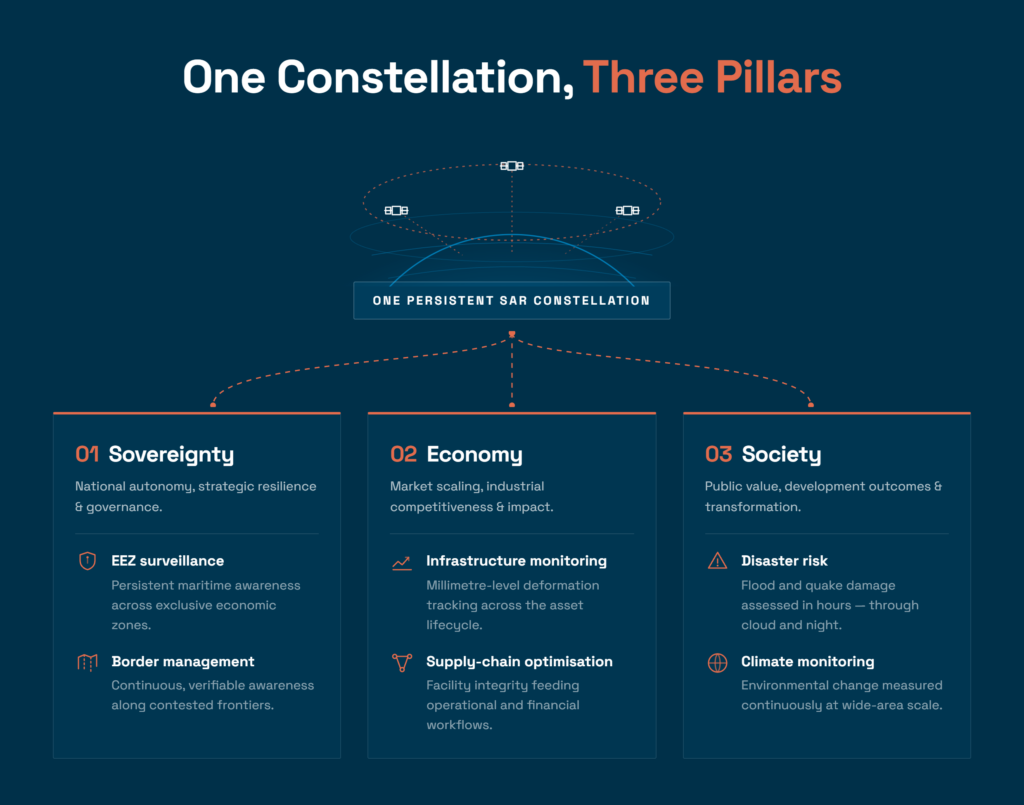
A concrete example of this logic in action is the shared utilisation of SAR satellite constellations and their analytical capabilities, as described above. EEZ surveillance and border management (sovereignty), infrastructure monitoring and supply chain optimisation (economy), and disaster risk and climate change monitoring (society) — all of these are realised through the same constellation responding to different demands. The priority of those demands will shift with time and circumstances, but the value of the infrastructure itself compounds across all three pillars. Governments are required to design this pathway as a dynamic geospatial strategy, without losing sight of the medium-to-long-term perspective. To bring consistency to that strategy, the formulation of a service roadmap — addressing how each nation will tackle its own distinctive challenges — is what ultimately matters.


Post-2030 Outlook

Looking beyond 2030, how do you expect the role of geospatial and space infrastructure to fundamentally reshape national power, economic competitiveness, and societal functioning, and what strategic decisions must governments and industry take today to prepare for this transition?

Beyond 2030, geospatial and space infrastructure will become as foundational and universal as the electrical grid or the internet. As satellite constellations and analytics continue to evolve, it will become possible to continuously and quantitatively monitor global environmental change, the distribution of resources, and the dynamics of economic activity. This is a capability humanity has never possessed before: the ability to diagnose the Earth’s “current state” in real time and make decisions grounded in long-term simulation.

This capability becomes truly meaningful not merely when used by individual nations or corporations, but when it functions as a shared knowledge base for all of humanity. Challenges such as climate change, ecosystem degradation, and resource depletion cannot be resolved without continuous global-scale monitoring and coordinated decision-making that transcends national and sectoral boundaries. What will be needed beyond 2030 is not only the development of technical infrastructure, but the joint formulation of cross-national and cross-sectoral roadmaps for sharing that infrastructure. This is precisely the structural condition for realising — as a post-SDGs framework — the role that the SDGs themselves failed to fulfil: a cycle grounded in scientific evidence, measuring progress quantitatively, and continuously updating action.

In this future, advanced AI — and ultimately, Super Intelligence — will become a partner that interprets vast volumes of Earth observation data, simulates complex interactions between systems, and supports human decision-making. The integration of geospatial infrastructure and Super Intelligence represents the condition under which humanity will, for the first time, be able to design and implement economic activities that genuinely account for the Earth’s carrying capacity.

We do not know what strategic decisions governments and industry must make. But we believe that individuals can begin to move, and that as those movements integrate, they can form a momentum. Synspective sees this future not as a distant ideal, but as a direct extension of today’s business activities. The construction of a SAR satellite constellation and the continuous accumulation and analysis of Earth observation data through it are the very first step in laying the foundation for this social infrastructure. Toward the realization of our mission — to create a new infrastructure that enables the next generation to understand our Earth and achieve a resilient future — we will steadily advance our business.

Mapping Urban Heat Islands in Ahemedabad

Mapping Urban Heat Islands in Ahemedabad
How Ahmedabad is Mapping Urban Heat Islands to Fight Climate Change

Even though the conversations on climate change have muted due to the geopolitical situation, trade disruptions, greater defence and intelligence spending, and shift in key policies, the negative effects of climate change are being faced all over the world. This however, does not signal that we have stopped working towards a positive climate action.

To highlight and discuss an important aspect of urban heat mapping, we have with us Mr. Urmil Bakhai who is a business leader with over 22 years of experience turning early-stage ideas into market-leading organizations.

HD Mapping and VPS: NextGen Geospatial Platforms for Business Enterprises and Location Intelligence | GWF 2026

HD Mapping and VPS: NextGen Geospatial Platforms for Business Enterprises and Location Intelligence | GWF 2026
HD Mapping and VPS: NextGen Geospatial Platforms for Business Enterprises and Location Intelligence

Plenary Session 5: High-Definition Mapping and Visual Positioning Systems: NextGen Geospatial Platforms for Business Enterprises and Location Intelligence | GWF 2026

This plenary session from Geospatial World Forum 2026 brings together leaders from Ordnance Survey, Google Maps, TomTom, Carto, Tech Mahindra, and Overture Maps Foundation to explore how high-definition mapping and visual positioning systems are reshaping geospatial infrastructure for enterprises, autonomous systems, and location intelligence at scale.

Moderator: Archita Shaktawat, Director – Consulting, Geospatial World

Speakers:

Space Infrastructure as a Service: Enriching Geospatial Platforms and Spatial Intelligence | GWF 2026

Space Infrastructure as a Service: Enriching Geospatial Platforms and Spatial Intelligence | GWF 2026
Space Infrastructure as a Service: Enriching Geospatial Platforms and Spatial Intelligence | GWF2026

Plenary Session 4 | Geospatial World Forum 2026 | Amsterdam, April 28 – May 1

This plenary session Moderate by Vaishali Dixit, VP – Americas, Geospatial World, brings together leaders from the space and geospatial sector to explore how satellite infrastructure is evolving into an on-demand, service-based model, and what that means for sovereignty, AI integration, and decision-making at a national and global scale.

Motoyuki Arai, CEO, Synspective, opens by outlining his company’s SAR satellite constellation and lays out a framework for understanding space infrastructure through three lenses: continuity, interoperability, and verifiability. He argues that as agentic AI becomes a new “end user” of satellite data, providers need open systems that keep humans in the decision-making loop while building toward sovereign, shared infrastructure among allied nations.

Anupam Anand, Joint Secretary, Department of Space, Government of India, IN-SPACe, details how IN-SPACe has opened India’s space sector to private enterprise since 2020, including liberalized FDI policy, public-private partnerships in earth observation, and the country’s ambitions to grow its space economy roughly fivefold over the next decade while expanding geospatial intelligence applications in agriculture, smart cities, and disaster resilience.

Milena Lerario, CEO, e-GEOS, discusses the shift from selling raw satellite data to delivering on-demand, decision-ready solutions, drawing on the company’s work with Copernicus, COSMO-SkyMed, and emergency response mapping, and previews the upcoming Leonardo constellation, which will process data onboard satellites via inter-satellite links.

Nicholas James Brown, Head of Office, UN Global Geodetic Centre of Excellence, delivers a sobering look at the “global geodetic supply chain”, the largely uncoordinated international system of ground observatories and analysis centers that keeps GPS, GNSS, and Earth observation satellites accurate. He warns that without better governance, awareness, and investment, satellite-dependent infrastructure across telecommunications, finance, and emergency services is at risk.

Vishal Thiruvedula, Vice President – Product, SatSure, closes the session by explaining how the company combines upstream satellite data, a geospatial AI foundation model, and downstream analytics to power agricultural lending, forestry compliance, and critical infrastructure monitoring across India and Southeast Asia.

Optimizing GeoAI and Digital Twins Towards Utilities and Network Management | GWF 2026

Optimizing GeoAI and Digital Twins Towards Utilities and Network Management | GWF 2026
GWF 2026 panel discussion on GeoAI and digital twins for network management

Plenary Session 3 | Geospatial World Forum 2026 | Amsterdam, April 28 – May 1

This plenary panel from Geospatial World Forum 2026 brings together leaders from telecom, geospatial, and enterprise technology to explore how GeoAI and digital twins are reshaping utilities and network management.

The session opens with a keynote from the CEO of network digital twin specialist Marcatur, who argues that telecom infrastructure built decades ago still relies on engineering data that’s often lost before it ever reaches a system of record. He makes the case for shifting from static “systems of record” to dynamic “systems of action,” and stresses that combining physical and logical network inventory is key to building reliable, real-time digital twins.

Moderator: Akanksha Tyagi, Senior Director – EMEA, Geospatial World

Panelist:

Spatial Computing and Digital Twins: Augmenting Space and Geospatial Value Chain | GWF 2026

Spatial Computing and Digital Twins: Augmenting Space and Geospatial Value Chain | GWF 2026
Spatial Computing and Digital Twins: Augmenting the Space and Geospatial Value Chain | GWF 2026

Plenary Session 2 | Geospatial World Forum 2026 | Amsterdam, April 28 – May 1

Moderated by Ananyaa Narain, VP – Consulting, Geospatial World, this plenary session brings together a keynote and panel of leaders from across the geospatial, AI, and infrastructure ecosystem to explore how spatial computing and digital twins are reshaping economies, governments, and societies.

Keynote by Jeroen Zanen, CEO, AI InfraSolutions, makes the case for sovereign-by-design geospatial infrastructure, democratized nationwide datasets, and a global movement of local pioneers — arguing that geospatial must become a source of competitiveness, not just cost.

Panelists include:

The discussion covers why governance — not technology — remains the biggest blocker to adoption, what separates static models from truly dynamic living digital twins, how spatial data can shift from cost center to economic driver, and why long-term public-private partnerships matter more than short-term project wins.

IPGF 2026: Inaugural Session Reiterates the Importance of Strategic Sovereignty Through Informational Sovereignty

0
IPGF 2026: Inaugural Session Reiterates the Importance of Strategic Sovereignty Through Informational Sovereignty

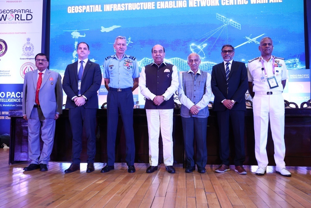
The inaugural session of the Indo Pacific GeoIntelligence Forum 2026 commenced with a welcome address by Lt Gen AKS Chandele, PVSM, AVSM, PhD (Retd) President – Defence Geospatial World, who highlighted the growing significance of networking, data centricity, and geospatial intelligence in modern military operations.

Reflecting on the relevance of this year’s theme, Lt. Gen. Chandele noted that the focus on connected systems and data-driven decision-making is becoming increasingly central to defence preparedness and operational effectiveness.

He set the stage by stating, “The Indian Army has declared the current year as the Year Sof Networking and Data Centricity.”

Vice Admiral AN Pramod, AVSM, YSM Director General Naval Operations (DGNO)
Indian Navy
,examined the rapidly evolving geopolitical landscape and its implications for regional security, military preparedness, and strategic partnerships.

Drawing attention to the increasing complexity of global security challenges, he highlighted how geopolitical uncertainty, ongoing conflicts, and the growing importance of strategic chokepoints are reshaping defence priorities worldwide. He also underscored the strategic significance of the Indo-Pacific as a region that connects major centres of commerce, innovation, and military power.

“We are more connected, yet more vulnerable; more technologically sophisticated, yet more exposed to misuse; more deeply interdependent, yet increasingly susceptible to pressure and coercion.”

Taking a bigger picture and focusing on the entire region, he said, “The Indo-Pacific connects the east coast of Africa to the western Pacific, linking major centres of commerce, production, innovation, and military power. In many ways, it is the world’s most consequential strategic theatre.”


Christopher Fowler, National Government Team Lead Asia Pacific, Esri
Singapore,
highlighted how Geographic Information Systems (GIS) provide the framework to bring together disparate datasets, support the intelligence cycle, and enable a common geospatial operating picture across the defence and intelligence enterprise.

“A GIS provides the framework to see and to understand what is occurring in the environment you are operating in and by bringing together and integrating multiple disparate datasets. This allows you to make informed decisions, take actions, and communicating this across all users,” he noted.

“The challenge isn’t just detecting individual events, it’s connecting them,” Christopher reiterated.

Air Marshal Praveen Keshav Vohra, UYSM, AVSM, VM DCIDS (PP & FD), HQ IDS, underscored the growing importance of geospatial infrastructure as a critical enabler of decision superiority in modern warfare. He highlighted how advances in AI, real-time ISR, cloud-based data fusion, and secure communications are transforming the way military forces perceive, understand, and act across the battlespace.

He also addressed the challenges associated with data interoperability, bandwidth, security classifications, and data quality that continue to shape the development of robust geospatial infrastructure.
Emphasizing the foundational role of geospatial infrastructure in modern warfare, he stated, “The geospatial infrastructure is the foundation of any modern battlefield. It gives the wisdom to understand and the precision to act.”
Highlighting the importance of geospatial advantage in future conflicts, he observed, “As we look forward to the future of multi-domain operations, the side with the best spatial map to the digital and physical world will be the side that will eventually prevail.”

Shri AS Kiran Kumar, Member, Space Commission and Former Chairperson
ISRO
,reflected on the transformative impact of space technology on society, security, and the way information shapes human behaviour. He noted how advancements in space-based observation, communications, and information dissemination have fundamentally changed the way humanity lives, interacts, and responds to global challenges.

Looking beyond technology alone, he emphasized the growing influence of narratives, information ecosystems, and emerging technologies on societies and nations. Calling for greater foresight and preparedness by urging stakeholders to look beyond immediate challenges and anticipate future disruptions that could reshape security, governance, and human progress, Shri Kumar brought forward the urgent need for deliberations.


“We need to look beyond what is happening today and start looking at how we can change the whole narrative and come up with solutions which will ensure that humanity not only survives on this planet but also lives peacefully.”

Underscoring the importance of human judgment in the age of AI, he noted, “Human intelligence needs to anticipate while world is trying to create artificial intelligence mimicking the human intelligence. Human intelligence itself, many times, is playing second fiddle.”

Lt Gen Syed Ata Hasnain, PVSM, UYSM, AVSM, SM, VSM*, Hon’ble Governor of Bihar, the Chief Guest for the inaugural session, shared his perspectives on the rapidly evolving character of warfare and the growing importance of geospatial intelligence, information dominance, and strategic sovereignty in modern security environments.

“The battlefield is now continuously observed, continuously analyzed, and continuously interpreted. Geography itself is no longer static terrain. It has become a dynamic data environment.”

On the Strategic Importance of the Indo-Pacific, he said, “The Indo-Pacific cannot be secured merely through naval presence or military posture. It must first be understood through persistent geospatial awareness.”

“Strategic sovereignty in the 21st century will increasingly depend not merely upon territorial control, but upon informational sovereignty,” he emphasized.

His address provided a powerful perspective on how nations must build resilience, strengthen geospatial capabilities, and embrace emerging technologies to navigate an increasingly complex security landscape.

Concluding the inaugural session, Sanjay Kumar, Chief Executive Officer, Geospatial World, reflected on one of the central themes that emerged throughout the discussions, the need to build sovereign geospatial and space infrastructure that strengthens national security while ensuring technological independence.

Drawing from the deliberations of the Executive Roundtable and the day’s discussions, he emphasized that sovereignty is not limited to ownership alone. Rather, it is about having command and control over critical technological assets, whether developed indigenously or strategically acquired, customized, and integrated to meet national requirements.
Reflecting on the meaning of sovereignty in today’s technology-driven world, he noted, “Sovereignty means that we need the control and command on the technological assets which we have.”

Highlighting the need for a balanced approach towards capability development, he emphasized, “We build our own. We procure, leverage, customize, and actually develop whatever is available in the best of the markets so that we don’t lose time.”


Underscoring the role of defence in technological advancement, he observed, “Defense around the world has been the incubator of technology.”

Geospatial Sovereignty, Spatial Justice & Africa’s Future | Mzwanele Nyhontso | GWF 2026

Geospatial Sovereignty, Spatial Justice & Africa’s Future | Mzwanele Nyhontso | GWF 2026
Mzwanele Nyhontso speaking at Geospatial World Forum 2026 about geospatial sovereignty and spatial justice.

At Geospatial World Forum 2026, Mzwanele Nyhontso, Minister of Land Reforms & Rural Development, Republic of South Africa, delivers a keynote on geospatial sovereignty, spatial justice, governance, and sustainable development in an increasingly uncertain world.

Addressing global conflict, economic instability, climate vulnerability, and historical inequality, he explains why geospatial capability is no longer just a technical requirement, but a fundamental pillar of governance, resilience, and socio-economic transformation. Speaking from the perspective of South Africa and the broader Global South, he highlights how geospatial intelligence can support land reform, climate resilience, food security, public investment, and equitable access to opportunity.

He emphasizes that geospatial information is not simply about maps or data platforms, but about enabling governments to govern with evidence, precision, and accountability. The keynote also explores the importance of spatial justice, sovereign data governance, indigenous land protection, sustainable development, and international cooperation through global geospatial frameworks.

He further discusses how geospatial intelligence and AI-powered systems can help nations build capable states, strengthen economies, and create more connected and inclusive societies.

The Future of Geospatial AI, Digital Twins & Sovereign GIS | Damian Spangrud | GWF 2026

The Future of Geospatial AI, Digital Twins & Sovereign GIS | Damian Spangrud | GWF 2026
Damian Spangrud speaking at Geospatial World Forum 2026 about geospatial AI, digital twins, and sovereign GIS.

At Geospatial World Forum 2026, Damian Spangrud, Managing Director of Esri, explores how geography, GIS, digital twins, and AI are reshaping the future of governments, industries, and society.

In this thought-provoking keynote, he explains why geography remains one of humanity’s most powerful tools for understanding the world — and why spatial computing is becoming the foundation of the machine-driven era. From sovereign GIS and hybrid cloud infrastructure to digital twins, GeoAI, and autonomous systems, he outlines how geospatial technologies are evolving from static mapping systems into intelligent, living infrastructures powering both humans and machines.

He discusses the growing importance of geospatial intelligence for sovereignty and governance, the evolution of GIS into enterprise-scale spatial infrastructure, and the rise of hybrid geospatial ecosystems. He also explores how digital twins, AI, and autonomous systems are transforming cities, infrastructure, and decision-making, while emphasizing the long-term value of trusted, living digital twins.

Highlighting decades of transformation across the geospatial industry, Damian Spangrud emphasizes that spatial thinking is no longer niche — it is becoming essential infrastructure for the future of economies, organizations, and society itself.

Space for All: Why Geospatial Sovereignty is Every Nation’s Right | GWF 2026

Space for All: Why Geospatial Sovereignty is Every Nation’s Right | GWF 2026
Aarti Holla Maini speaking at Geospatial World Forum 2026 plenary session in Amsterdam

In this powerful opening address at Geospatial World Forum 2026, Aarti Holla Maini, Director of UNOOSA (United Nations Office for Outer Space Affairs), makes the case that geospatial capability is no longer a technical luxury — it is a foundation of modern sovereignty.

From flood mapping to food security, satellite data is already shaping how nations govern, grow, and protect their people. Yet the benefits remain deeply unequal. Some countries build sovereign space capabilities at speed. Others depend entirely on external data, platforms, and expertise.

Aarti calls for three urgent priorities: trusted data, inclusive capability, and international cooperation — and invites the global geospatial community to ensure that no country is left without the tools it needs to shape its own future.

Indo Pacific GeoIntelligence Forum 2026 to Advance Strategic Dialogue on Network-Centric Warfare and Defence Geospatial Capabilities

0
Indo Pacific GeoIntelligence Forum 2026 to Advance Strategic Dialogue on Network-Centric Warfare and Defence Geospatial Capabilities

Amid rapidly evolving geopolitical dynamics and emerging security challenges across the Indo-Pacific, the Indo-Pacific GeoIntelligence Forum 2026 (IPGF 2026) will convene senior defence leadership, strategic policymakers, intelligence agencies, and technology innovators on June 2–3, 2026 at the Manekshaw Centre, New Delhi.

Organized by Geospatial World, the 16th edition of the forum will deliberate on the theme: “Geospatial Infrastructure Enabling Network Centric Warfare.” The forum will examine how geospatial intelligence, space-based assets, AI-enabled systems, and secure digital infrastructure are strengthening operational preparedness, decision superiority, and integrated multi-domain operations.

As defence forces across the globe accelerate the transition toward data-centric and technology-enabled warfare, IPGF 2026 will serve as a strategic platform to address emerging operational requirements across land, maritime, air, cyber, and space domains.

Highlighting the significance of geospatial systems in modern military operations, the Directorate General of Information Systems (DGIS) has consistently emphasized the role of geospatial technologies in enhancing situational awareness, operational agility, and mission effectiveness for the Armed Forces.

“We are excited to be a Knowledge Partner with Geospatial World at IPGF 26. This is a unique and invaluable opportunity to collaborate with technology experts, industry and academia to help formulate a security strategy for the Indo Pacific”– Lt Gen Harsh Chhibber, AVSM, VSM, PhD, Director General Information Systems (DGIS), Indian Army

Speaking on the strategic relevance of the forum, Lt Gen AKS Chandele, PVSM, AVSM, PhD (Retd), President – Defence, Geospatial World, stated:
“Future conflicts will increasingly be defined by information dominance, integrated intelligence, and real-time operational awareness. Geospatial infrastructure has become a force multiplier in enabling network-centric operations and strategic decision-making.”

IPGF 2026 is expected to witness participation from:

  • Senior leadership from the Armed Forces and defence establishments
  • Government ministries and strategic agencies
  • Global defence and aerospace organizations
  • Space agencies and GEOINT experts
  • Industry leaders, startups, and academia
  • Armed Forces from Indo-Pacific nations

The forum agenda will feature strategic plenaries, operational case studies, capability demonstrations, and leadership dialogues focused on:

  • Multi-domain command and control
  • Geospatial intelligence for operational planning
  • Space-enabled defence capabilities
  • Maritime domain awareness and Indo-Pacific security
  • AI-driven ISR and decision support systems
  • GNSS resilience, electronic warfare, and cyber defence
  • Secure communications and sovereign geospatial infrastructure
  • Autonomous systems and next-generation battlefield technologies

A major highlight of IPGF 2026 will be the Defence Geospatial & Technology Exhibition, bringing together leading organizations working at the intersection of defence, geospatial intelligence, AI, autonomous systems, and space technologies. Confirmed exhibitors and technology participants include Esri India, Planet, Roter, Vantor, Suhora Technologies, Auric AI Labs, VyomIC, Aetosky, MicroGenesis TechSoft, Skipper Tech, and SPRY, among others. These organizations will showcase advanced capabilities in GEOINT, Earth observation, ISR platforms, AI/ML, secure communications, digital twins, drone technologies, and mission-critical geospatial solutions.

The exhibition will provide a high-level engagement platform between technology providers, military stakeholders, procurement authorities, and strategic decision-makers, fostering collaboration on future-ready defence capabilities and indigenous innovation.

At a time when nations are prioritizing defence modernization and sovereign capability development, IPGF 2026 aims to strengthen strategic collaboration, enhance interoperability, and accelerate the adoption of geospatial and space technologies for mission-critical operations.

The forum will reinforce the growing recognition that future-ready defence forces will be shaped by resilient geospatial infrastructure, real-time intelligence integration, and the ability to operate seamlessly across interconnected operational domains.

For more information, agenda, speakers, and participation details, visit:
Indo-Pacific GeoIntelligence Forum 2026

Geospatial Intelligence is no Longer Optional: Dr Khalifa Al Romaithi | GWF 2026

Geospatial Intelligence is no Longer Optional: Dr Khalifa Al Romaithi | GWF 2026
Dr Khalifa Al Romaithi at GWF 2026

In this keynote address at the Geospatial World Forum 2026 in Amsterdam, Dr Khalifa Al Romaithi Chairman of UAE’s Federal Geographic Information Center (FGIC) delivers a compelling case for sovereign geospatial infrastructure as a strategic national asset.

He emphasizes that geospatial intelligence has undergone a fundamental transformation — stressing that it is no longer optional, but a strategic enabler of sovereignty, prosperity, and societal stability. He argues that governments which recognize and invest in sovereign geospatial infrastructure gain a significant advantage in security, innovation, crisis response, and governance, ultimately shaping their future autonomy and resilience.

He highlights the UAE’s national approach through the Federal Geographic Information Center, underlining how the country has built an integrated geospatial ecosystem built on uniform standards, official reference datasets, national platforms, and a robust governance framework. He points out that this foundation has enabled the effective use of geospatial intelligence across critical sectors including digital government, infrastructure development, environmental sustainability, public safety, and national security.

Above all, he stresses that geospatial knowledge today must be recognized as a key enabler of sound policy, economic growth, and long-term national resilience. He underscores that achieving this depends on trusted data, shared innovation, and close collaboration between government, industry, and academia.

Data, Sovereignty & Cooperation: Welcome Address by Cora Smelik | GWF 2026

Data, Sovereignty & Cooperation: Welcome Address by Cora Smelik | GWF 2026
Cora Smelik delivering the opening keynote at Geospatial World Forum 2026 in Amsterdam

In this opening keynote at the Geospatial World Forum 2026 in Amsterdam, Cora Smelik — Member of the Executive Board of Kadaster — delivers a thought-provoking opening address on digital sovereignty, open strategic autonomy, and the role of geospatial data in modern society.

Speaking on King’s Day, she draws a powerful parallel between Dutch civic values and the forum’s central theme: that sovereignty is not about isolation or protectionism, but about maintaining control, accountability, and the freedom to cooperate on your own terms.

She argues that in a world shaped by geopolitical shifts and growing dependency on large technology providers, public institutions must pursue open strategic autonomy — retaining the ability to make independent choices while avoiding unwanted dependencies. For organizations like the Kadaster, digital sovereignty is not an abstract concept but a practical necessity, underpinning legal certainty, public trust, and the functioning of the wider economy.

Rather than a retreat behind borders, she presents sovereignty as an invitation to cooperate — built on shared standards, reliable partnerships, and interoperability across European and international networks. True resilience, she argues, is only achieved when strengths are combined. And behind every dataset, algorithm, and system, there are human choices and human values that shape the society we live in.

Welcome & Opening Address by Sanjay Kumar | GWF 2026

Welcome & Opening Address by Sanjay Kumar | GWF 2026
Sanjay Kumar delivering the Welcome & Opening Address at Geospatial World Forum 2026.

At Geospatial World Forum 2026, Sanjay Kumar, CEO of Geospatial World, highlighted how the geospatial industry is entering a defining decade of transformation, driven by sovereign infrastructure, AI, autonomy, and real-time digital ecosystems.

He noted that the industry, currently valued at USD 670 billion, is projected to reach nearly USD 1.3 trillion by 2030, as the world moves from creating maps for humans to building intelligent mapping systems for machines and autonomous operations. He emphasized that technologies such as digital twins, automation, and spatial intelligence are fundamentally reshaping how governments, industries, and societies function.

Speaking about the broader global landscape, he stated that sovereign geospatial capabilities are no longer optional, but essential for economic resilience, governance, and national security. He also acknowledged the growing role of governments as active facilitators in building future-ready geospatial ecosystems.

Bringing together 40+ sponsors, 20+ institutional partners, and 15+ government organizations, GWF 2026 aims to foster global collaboration and accelerate innovation across the geospatial sector.

Geospatial World Unveils 50 Rising Stars at Geospatial World Forum in Amsterdam

0
Geospatial World Unveils 50 Rising Stars at Geospatial World Forum in Amsterdam

Amsterdam, Netherlands | April–May 2026 — Geospatial World honored the 50 Rising Stars 2026 contributing in the geospatial and space industry — one of the industry’s most coveted recognitions for young geospatial professionals, during a dedicated ceremony at the Geospatial World Forum (GWF) 2026, held at the RAI Amsterdam, the Netherlands.

Now in its sixth year, the Rising Stars initiative celebrates extraordinary individuals under the age of 40 who are reshaping the geospatial landscape through innovation, leadership, research, and community impact. The 2026 cohort, drawn from more than 300 global nominations, represents a generation that is not simply applying geospatial tools but actively redefining what those tools can do for economies, societies, and the planet.


A Generation Defining the Next Era of Spatial Intelligence

The 2026 cohort reflects the defining currents of the modern geospatial moment: the fusion of artificial intelligence with location data, democratization of Earth observation, growing role of geospatial science in climate resilience and public health, and an urgent push for inclusivity across an industry historically dominated by a narrow demographic.

Selected by an independent, internationally constituted jury panel from over 300 nominations, the 2026 cohort spans more than 30 countries across six continents. Honorees represent the full breadth of the geospatial and space ecosystem, from GIS analysts and remote sensing scientists to geospatial AI researchers, surveyors, space researchers, cartographers, entrepreneurs, and policy advocates.

Sectors represented in the 2026 class include public health and epidemiology, climate and disaster risk management, urban planning and smart cities, precision agriculture, defense and intelligence, infrastructure and utilities, and Earth observation.

Several honorees work at the intersection of geospatial science and the United Nations Sustainable Development Goals, embedding spatial thinking into the fight against food insecurity, vector-borne disease, and environmental degradation.

The initiative’s sustained commitment to gender equity and geographic diversity is reflected in this year’s list, with a significant proportion of honorees from the Global South and a strong representation of women in technical, research, and leadership roles.

“What drives us at Geospatial World is a simple belief that recognition, at the right moment, can change the trajectory of a career and, through that career, impact entire communities. The 50 Rising Stars are not just exceptional young professionals; they are connectors, collaborators, and changemakers who are redefining how we understand and shape our world through geospatial thinking. As a jury member, it is truly inspiring to witness the passion, diversity of ideas, and sense of purpose these emerging leaders bring to the industry. At Geospatial World, we are committed to championing their journey, creating opportunities, and opening every door we possibly can for the next generation of geospatial leaders,” explained Annu Negi, COO, Geospatial World.


Presented at the World’s Premier Geospatial Gathering

The Rising Stars awards ceremony was held as part of the Geospatial World Forum 2026, which convened from 27 April to 1 May at the RAI Congress Centre, Amsterdam. GWF 2026 — themed Sovereignty, Economy & Society, brought together heads of national mapping agencies, ministers, CEOs, academics, technologists, and policy makers to address the most pressing questions at the intersection of geospatial infrastructure, digital sovereignty, and global resilience.

The Rising Stars award ceremony formed one of the Forum’s signature moments, celebrating the individuals who will carry the industry’s ambitions forward into the next decade.

About the Geospatial World 50 Rising Stars Initiative

Launched in 2021, the Geospatial World 50 Rising Stars is an annual initiative recognizing the outstanding accomplishments of individuals under the age of 40 who are proactively demonstrating the transformative value of geospatial technology to society, the environment, and the global economy. Honorees are selected through a rigorous, independent jury process from nominations submitted across the global geospatial community. The initiative is firmly committed to diversity, equity, and inclusion, with global representation as a core criterion.

The full 2026 Rising Stars list and individual honoree profiles are available at: geospatialworld.net/rising-stars/2026

About Geospatial World Forum

Geospatial World Forum (GWF) is the world’s foremost annual gathering of the geospatial community — a transformative platform convening global leaders, policy makers, technology innovators, and sectoral champions to build a shared vision for a geospatially empowered world. From data sovereignty to digital infrastructure, and from climate action to AI-driven location intelligence, GWF has helped shape how societies perceive, value, and utilize spatial knowledge for over a decade.

Prof. Dr. Paul Becker Receives Lifetime Achievement Award | Geospatial World Leadership Awards 2026

Prof. Dr. Paul Becker Receives Lifetime Achievement Award | Geospatial World Leadership Awards 2026
Prof. Dr. Paul Becker Wins Lifetime Achievement Award | Geospatial World Leadership Awards 2026

Prof. Dr. Paul Becker is honored with the Lifetime Achievement Award at the Geospatial World Leadership Awards 2026, held on 29th April 2026 at the Geospatial World Forum in Amsterdam.

Over four decades, Prof. Becker has built the geodetic foundations the entire geospatial world depends on — from leading the Federal Agency for Cartography and Geodesy (BKG) to establishing the United Nations Global Geodetic Centre of Excellence in Bonn in 2023, extending foundational infrastructure to nations worldwide.

Geospatial Ambassador of the Year — Ingrid Vanden Berghe | Geospatial World Leadership Awards 2026

Geospatial Ambassador of the Year — Ingrid Vanden Berghe | Geospatial World Leadership Awards 2026
Ingrid Vanden Berghe Wins Geospatial Ambassador of the Year | Geospatial World Leadership Awards 2026

Ingrid Vanden Berghe is honored as the Geospatial Ambassador of the Year at the Geospatial World Leadership Awards 2026, held on 29th April 2026 at the Geospatial World Forum in Amsterdam.

Administrator General of Belgium’s National Geographic Institute and Co-Chair of UN-GGIM since 2025, Ingrid has been the driving force behind the UN-GGIM Strategic Framework 2025–2030 — championing geospatial governance, European cooperation, and diversity in the geospatial field.

GW Bulletin