In this insightful panel at GeoBuiz Summit 2026, industry leaders explore how location intelligence is powering next-generation retail strategies — from digital twins and site selection to last-mile delivery, real-time customer insights, and enterprise decision-making. The discussion highlights how trusted location data, AI-driven analytics, and platform integration are reshaping logistics, fulfillment, and customer experience in an increasingly dynamic retail environment.
The conversation covers how retailers are using geospatial intelligence to optimize store networks, improve logistics performance, maintain customer trust in data usage, and gain competitive advantage through predictive insights.
Watch the full panel to understand how geospatial technology is becoming the foundation of next-generation retail and e-commerce innovation.
Moderator: Vaishali Dixit, Vice President – Americas, Geospatial World
Speakers:
Bryan Chandler, Managing Director & Senior Vice President Technology and Innovation, The Shopping Center Group
Geospatial data platforms transforming decision making panel at GeoBuiz Summit 2026
In this insightful panel discussion at GeoBuiz Summit 2026, industry and public sector leaders explore how geospatial platforms are enabling real-time decision-making, AI integration, data interoperability, and enterprise-scale operations.
The conversation dives into challenges around data governance, privacy, continuous updates, and the growing role of human oversight in AI-driven workflows.
Watch the full panel to understand how geospatial data platforms are becoming the backbone of modern digital decision-making.
Moderator: Brittany Donald, Director Program Management, Geospatial World LLC
The discussion examines emerging solutions including LEO satellite constellations, quantum timing technologies, secure signal architectures, and multi-layered PNT frameworks designed to reduce reliance on single navigation systems. Experts share real-world examples of aviation disruptions, infrastructure risks, and the growing demand for precision across autonomous systems, telecom networks, finance, and critical infrastructure.
The panel also explores how governments and commercial providers are building diversified PNT ecosystems — integrating space-based, terrestrial, and network-based timing sources to ensure reliability, sovereignty, and operational continuity.
Watch the full discussion to understand why resilient PNT is becoming foundational to modern infrastructure, autonomy, and global digital systems.
Moderator: Mark Reichardt, Senior Consultant, Geospatial World
Space Infrastructure as a Service for Enterprise Geospatial Applications | GeoBuiz Summit 2026
In this panel fromGeoBuiz Summit 2026, global leaders from government agencies, satellite companies, and geospatial technology providers explore how space-based sensing is evolving into foundational infrastructure for enterprises and governments.
The discussion examines how Earth observation is shifting from isolated projects to continuously available services — enabling real-time insights, operational intelligence, and data-driven decision-making at scale. Panelists share perspectives on democratizing access to satellite data, integrating space-based and terrestrial information, and building collaborative “system-of-systems” architectures for the future.
They also address key industry challenges including data interoperability, accuracy, latency, trust, and governance — while exploring how AI, data fusion, and service-based delivery models are reshaping the next generation of geospatial applications.
Watch the full panel to understand how space infrastructure is becoming as essential as digital networks — powering smarter decisions across defense, environment, infrastructure, and enterprise operations.
Patrick Cozzi keynote on AI digital twins transforming infrastructure engineering at GeoBuiz Summit 2026
In this keynote at GeoBuiz Summit 2026, Patrick Cozzi, Chief Platform Officer of Bentley Systems, shares strategic insights on how artificial intelligence, digital twins, and open geospatial platforms are transforming the future of infrastructure engineering.
Drawing from his work with Cesium and Bentley’s infrastructure ecosystem, Patrick explores how software, automation, and data interoperability are helping address global challenges such as aging infrastructure, workforce shortages, and increasing project complexity. He explains how AI-assisted design, reality capture, and full-lifecycle digital twins are improving efficiency across planning, design, construction, and operations.
The keynote also highlights the importance of open standards, platform-based innovation, and collaborative ecosystems — demonstrating how technologies from NVIDIA, Google, and Autodesk are enabling scalable, interoperable 3D geospatial environments.
Watch the full keynote to understand how AI-driven digital twins, developer innovation, and integrated geospatial infrastructure are reshaping engineering workflows and accelerating the next era of digital transformation.
Enterprise spatial intelligence discussion at GeoBuiz Summit 2026 featuring geospatial industry leadership insights
In this insightful conversation at GeoBuiz Summit 2026, Sanjay Kumar, the CEO of Geospatial World speaks with Dan Smoot, CEO of Vantorabout the evolving future of geospatial intelligence and Earth observation.
The discussion explores how the industry is shifting from imagery and analytics to spatial intelligence and actionable insights, powered by AI, high-definition 3D mapping, and integrated space-to-ground data. Dan shares how application-driven platforms, subscription models, and real-time change detection are transforming how governments, enterprises, and consumers use geospatial data.
Key topics covered include GPS-denied navigation, autonomous systems, digital twins of the Earth, and the growing importance of sovereign geospatial capabilities. The conversation also highlights strategic partnerships shaping the ecosystem, including collaborations with Satellogic, Palantir Technologies, Anduril Industries, and Niantic Spatial.
Watch the full conversation to understand how spatial intelligence is redefining mapping, national infrastructure, and the future of the global geospatial economy.
Drone photographs at sunset, golden hour of the harvest of a vineyard in Barmera, South Australia
Drone photographs at sunset, golden hour of the harvest of a vineyard in Barmera, South Australia
The Australasian Space Innovation Institute (ASII), an independent, not-for-profit organisation translating world-class research into space-enabled solutions, has launched a $15 million National Digital Twin for Australian Agriculture to establish a capability for coordinated decision-making and innovation across the agriculture, forestry, and fisheries system at a national scale.
This flagship initiative will deliver a sovereign, AI-enabled geospatial digital twin that integrates satellite Earth Observation, IoT and sensor data, climate data and agronomic models into a shared digital environment to create a dynamic, virtual replica of Australia’s agricultural landscapes, designed as a whole-of-agriculture capability.
Supported by Elders, Meat & Livestock Australia and Charles Sturt University (CSU), the digital twin will serve as a living R&D engine for faster, lower-risk innovation, empowering industry stakeholders to lift productivity, strengthen resilience and accelerate growth across the entire sector.
Its AI-enabled capabilities support predictive scenario modelling across climate resilience, biosecurity, water management and productivity, enabling decision-makers to test options, anticipate risks and optimise actions before implementation.
Professor Andy Koronios, founding CEO and Managing Director of ASII, said: “Australia has world-class agricultural, forestry and fisheries capability, but we lack a shared national capability to turn that strength into decision-ready insight at scale.
“The National Digital Twin provides that missing layer: a sovereign, AI-enabled environment where Australia can model scenarios, test outcomes, and make better decisions across productivity, resilience and policy. It is a national infrastructure for public good, best stewarded by an independent, not-for-profit institute like the ASII, for the benefit of the nation.”
Mick Crowley, Managing Director, Meat & Livestock Australia, said: “The Digital Twin creates the foundation for a new virtual R&D capability: scenario modelling and hypothesis testing inside a replica of agricultural environments. That means we can test livestock management options and research questions faster, refine trials before we invest in large scale field trials, adoption or commercialisation. Done well, this approach can save millions of dollars and years of research time compared with traditional methods, while lifting confidence in what we deploy at scale.”
Professor Renée Leon, Vice Chancellor, CSU, said, “The National Digital Twin for Australian Agriculture initiative is an important step forward for the whole sector. The Australian Agricultural Data Exchange at Charles Sturt University is already proving essential in bringing together relevant agricultural data. Now working with the National Digital Twin, they will jointly operate to transform Australia’s fragmented datasets into scalable, trusted outcomes for research, industry, and policy. This will equip our experts with the necessary information and linked data they need to carry out more effective experimentation, test hypotheses, and refine trials.”
Mark Allison, Managing Director and CEO of Elders and board member of the ASII, said, “Elders’ strength has always been our people and our relationships with farmers. The National Digital Twin builds on that by giving agronomists, advisors and agtech providers access to trusted, nationally consistent intelligence and a powerful environment to test and refine ideas before they reach the paddock. It aims to strengthen the advice that can be provided, while keeping relationships and judgement firmly with the advisor.”
The Future of Open Maps & Geospatial Collaboration | Conversation with Will Mortenson
This insightful conversation from the GeoBuiz Summit 2026 features Sanjay Kumar, CEO, Geospatial World in discussion with Will Mortenson, Executive Director of the Overture Maps Foundation, exploring how open, standardized geospatial data is transforming the mapping ecosystem.
The discussion explores why competing organizations are working together to build a shared global basemap, how the Global Entity Reference System (GERS) enables consistent data integration, and how layered data frameworks enrich geospatial intelligence. The conversation also highlights the growing importance of open data collaboration between governments and industry, the critical role of standardized location data in enabling AI and digital twins, opportunities to expand mapping in underrepresented regions, and the long-term vision for geospatial innovation across Asia and beyond.
Expert panel discussing SaaS, PaaS, and AI-as-a-Service business model evolution in the geospatial industry.
In this insightful panel discussion moderated by Ananyaa Narain, Vice President – Consulting, Geospatial World, industry leaders explore how cloud platforms, data services, governance, interoperability, and trust are shaping the future of AI-driven business models.
The conversation covers governance and interoperability challenges, subscription and consumption models, enterprise data strategies, trust in AI systems, and how organizations can successfully transition toward AI-as-a-Service. Watch to gain expert perspectives on the future of digital platforms, data monetization, and AI-enabled transformation — and why productivity, cost efficiency, and trust will define the next wave of innovation.
In this exclusive interview, Simon Navin, Head of Geospatial Services atOrdnance Survey, shares how advanced location data is transforming decision-making across climate resilience, energy efficiency, and infrastructure planning.
The discussion explores Ordnance Survey’s groundbreaking analysis of 23.6 million homes, revealing how housing characteristics influence heat retention and fuel poverty risk. Using insights from the National Geospatial Database (NGD), the organization developed a heat index to identify vulnerable properties and support evidence-based policy planning.
Simon explains how structured geospatial data enables large-scale spatial analysis — supporting urban planning, infrastructure development, smart cities, digital twins, and climate risk modelling. He also discusses how satellite-derived Earth observation data helps map global heat patterns and guide environmental interventions such as tree planting, urban design, and resilience planning.
Looking ahead, the conversation dives into the role of AI, machine learning, and Positioning, Navigation and Timing (PNT) in shaping the future of national mapping. From automation and predictive analytics to secure and trusted geospatial systems, emerging technologies are redefining how governments and industries use location intelligence.
Exploring the future of spatial intelligence and AI-driven geospatial understanding.
In this GeoBuiz Summit 2026 keynote, Erik Jorgensen, Chairman & CEO of Vexcel Imaging, unveils an early preview of Real-World AI as a Service and explores how geospatial data, foundation models, and inference engines are coming together to make the physical world truly queryable.
Moving beyond traditional machine learning and rule-based feature extraction, this session demonstrates how multimodal geospatial embeddings enable AI systems to understand context, intent, and real-world semantics. From identifying safe pedestrian crossings and distressed properties in luxury neighborhoods to locating 5G-ready communication towers and high-risk infrastructure assets, the keynote showcases how inference-driven spatial queries could redefine decision-making across industries.
Experts discuss the future of spatial computing and digital twins at GeoBuiz Summit 2026.
In this insightful panel from GeoBuiz Summit 2026, industry leaders explore how digital twins, satellite connectivity, and spatial computing are reshaping infrastructure, asset management, and enterprise decision-making.
Experts from Autodesk, Woolpert, and Skylo Technologies discuss how digital twins are evolving from static models to dynamic, live representations powered by real-time data, AI, and ubiquitous connectivity. The conversation highlights how federated digital twins, platform ecosystems, and integrated data workflows are enabling smarter planning, construction monitoring, and operational optimization across industries.
The panel also examines where organizations are seeing the highest ROI from digital twins — particularly in early planning, construction monitoring, and real-time operations — along with the critical role of satellite networks, advanced mapping, and high-precision data capture in powering spatial computing environments.
From nationwide digital twin initiatives to high-precision infrastructure modeling, this session offers valuable insights into the technologies and strategies driving the next phase of digital transformation in the geospatial ecosystem.
Moderator: Vaishali Dixit, Vice President – Americas, Geospatial World
Speakers:
Theo Agelopoulos — Vice President, AEC Design Strategy, Autodesk
Amar Nayegandhi — Global Head of Technology & Geospatial Sector Leader, Woolpert
Vijay Krishnan — Vice President of Strategic Partnerships, Skylo Technologies
The global AEC (Architecture, Engineering & Construction) industry enters 2026 with renewed confidence and structural transformation. After a period of volatility, the sector is stabilizing—projected to reach a market size of USD 14.19 trillion in 2026 and grow to USD 17.24 trillion by 2030, driven by infrastructure investment, digital mandates, and sustainability goals. This video breaks down the five defining technology trends shaping the AEC industry in 2026, as technology shifts from a supporting tool to the backbone of infrastructure delivery.
Scaling Seaweed Production across India through Combining Satellite and Oceonographic Data
In a conversation with Devleena Bhattacharjee, Founder & COO, ClimaCrew about securing a strategic investment, scaling the seaweed across India, and using satellite and oceonographic datasets for social adoption for seaweed farming.
At GeoBuiz Summit 2026, Brian McClendon, CTO at Niantic Spatial, joins Sanjay Kumar, CEO, Geospatial World, for an in-depth conversation on the future of spatial computing and world-scale geospatial intelligence.
Brian explores how geospatial data is evolving from traditional maps into world models that enable machines, robots, and autonomous systems to understand the physical environment. He explains why digital twins must move beyond visualization to become semantic, predictive representations of reality, and how advances in AI, 3D data, and visual positioning are reshaping enterprise and industrial applications.
Drawing on decades of experience in mapping and spatial platforms, the conversation highlights a fundamental shift—from drawing the world to understanding it—and what this means for the next generation of digital twins, enterprise GIS, and the global geospatial ecosystem.
GeoBuiz Summit 2026 Keynote | Spatial Computing, Digital Twins & the Future of Enterprise GIS
In this Keynote Address at GeoBuiz Summit 2026, Damian Spangrud, Director – Solutions at Esri, explores how spatial computing, digital twins, and AI are reshaping enterprises and transforming the role of geospatial technology.
He explains how location is becoming the common language that unifies legacy systems, new platforms, field operations, and enterprise data—turning GIS into a system of record for organizations. As spatial computing matures, it is enabling deeper collaboration, smarter decision-making, and new ways to understand assets, facilities, communities, and the planet.
A central focus of the keynote is the evolution of digital twins—from descriptive models to informative and predictive systems that deliver real business value. Damian emphasizes that digital twins are not just visual models, but trusted sources of reality that support operational efficiency, compliance, risk management, and enterprise-wide insight.
The keynote also examines how geospatial AI and intelligent agents are changing how organizations interact with spatial data—moving beyond tools and tasks toward answers, automation, and workflows at scale. As geospatial becomes a tier-one enterprise system, the keynote highlights the importance of aligning spatial intelligence with business outcomes to drive adoption and impact.
This keynote reinforces the conference theme of mainstreaming geospatial, calling for collective leadership across industry, technology, and policy to build spatially enabled enterprises and a stronger global geospatial ecosystem.
Industry leaders discuss AI, spatial computing, and geospatial intelligence at GeoBuiz Summit 2026, held in Denver, USA.
At GeoBuiz Summit 2026, global technology leaders, geospatial experts, and investors came together to examine how deep tech is transforming spatial analytics and geospatial intelligence. This panel discussion focuses on the convergence of artificial intelligence (AI), machine learning, spatial computing, and advanced geospatial analytics, and how these technologies are reshaping decision-making across industries.
Speakers from Google, Wherobots, NeoGeoInfo Technologies , and Stout Street Capital share real-world perspectives on the evolution of spatial intelligence—from traditional mapping systems to AI-powered, context-aware, and real-time geospatial platforms.
Key Themes Discussed:
What deep tech means in the geospatial ecosystem
AI and LLMs in spatial analytics and GIS workflows
Spatial computing, digital twins, and physical AI
Integrating imagery, video, LiDAR, and real-time data pipelines
Trust, accuracy, explainability, and data readiness for AI
Investor outlook on near-term and scalable deep tech innovations
The future of geospatial intelligence for infrastructure, mobility, and national security
Why This Session Matters
The discussion highlights a major shift in the geospatial industry: moving from static maps to evidence-based, actionable, and AI-driven spatial intelligence. As enterprises and governments increasingly rely on real-time spatial insights, the ability to combine deep tech with geospatial data will define competitive advantage over the next decade.
This session is especially relevant for GIS professionals, AI practitioners, urban planners, infrastructure leaders, policymakers, startups, and investors.
GeoBuiz Summit 2026 | Welcome and Opening Address by Sanjay Kumar
In this Opening Address at GeoBuiz Summit 2026, Sanjay Kumar, CEO of Geospatial World, sets the strategic context for the global geospatial industry and its evolution from buzz to business.
He explains how innovations once viewed as emerging trends have matured into real economic impact, with the global geospatial market now valued at $677 billion. While geospatial has grown into a larger direct market than space, space continues to play a critical enabling role through Earth observation, GNSS, and satellite connectivity.
The address highlights the growing convergence of geospatial and space technologies as foundational pillars of digital infrastructure, driving the transition toward the autonomous age. As Sanjay Kumar emphasizes, maps are no longer created and consumed only by humans—machines are now active participants, enabled by spatial computing and digital twins.
He also underscores how governments worldwide are increasingly recognizing geospatial as critical national infrastructure, essential for development, resilience, security, and enterprise growth.
Fuel Poverty in the UK has become a significant issue as households struggle to afford adequate warmth and energy services, primarily due to a combination of low incomes, high energy costs, and poor home energy efficiency.
To address the issue, the UK government recently announced the £15 billion Warm Homes Plan, aimed at helping millions of families with energy-efficient improvements by 2030.
Turning up the heaters is only a preliminary solution to this problem, with heat retention inside the homes being of significant value, which is often overlooked.
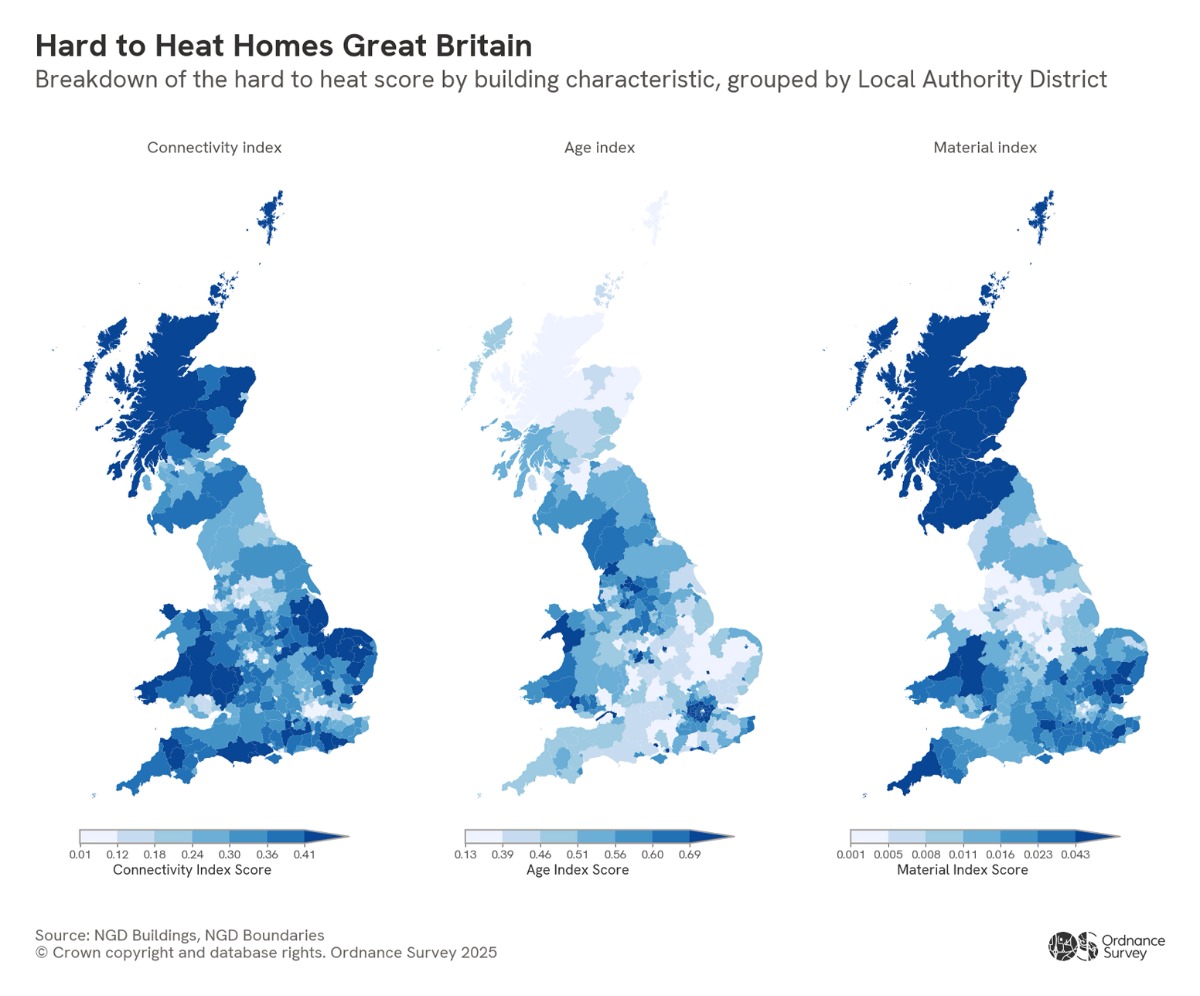
Working to identify the causes, Ordnance Survey, Great Britain’s national mapping agency, analysed 23.6 million homes using the OS National Geographic Database (NGD). Through this, OS NGD identified over 600 million features affecting the heating conditions – from identifying trends to comparing the physical characteristics of homes using a heat index to assess how easy they are to heat.
The Pros of Urban Living
According to Ordnance Survey’s data patterns, urban areas are generally warmer and have low heat-loss risk. This is influenced by a range of factors, including the urban heat island effect, higher ambient temperatures, and denser, often newer housing stock.
In London, boroughs such as Tower Hamlets rank among the easiest to heat, likely due to the high proportion of flats (21%) with shared walls, modern construction standards, and the lowest percentage of pre-1960 buildings (37%).
Glasgow has a higher proportion of flats and high-rise buildings, assuming that with shared walls, they might retain heat better. New towns such as Milton Keynes are also easier to heat, as the majority of homes (around 85%) were built after 1960, giving it the second-lowest heat index of all Local Authorities.
Changing Point
The 1960s in the UK were critical, as many earlier homes had insulation standards that were not suitable for the current weather behaviours, such as stone or timber.
Building regulations introduced in the mid-1960s began requiring insulation, and standards have tightened significantly since then. Homes built after this period tend to feel warmer and less damp, meaning they require less energy to heat. Homes built post-1960 generally have better insulation, cavity walls, and double glazing, reducing heating bills and preventing damp and condensation.
Region-wise, hilly and mountainous regions such as the Scottish Highlands, Peak District, and Lake District, and three national parks in Wales are more exposed to harsh weather and tend to have older stone farmhouses and traditional buildings. Wales also has the oldest housing stock in the UK, largely due to industrial-era terraced housing built during the 19th century.
Working towards a Solution
Using OS data, it’s possible to identify south-facing rooftops suitable for solar panels, which could help households reduce energy costs. In South Cambridgeshire, 14% of residential properties already have solar panels installed. These solar panels work throughout winter, because they rely on daylight rather than temperature, although shorter daylight hours do reduce output.
Additionally, reconstructing old houses into new ones with better insulation can also work to keep localities and areas warmer. For example, Cambridgeshire has a lower heat index likely due to a high proportion of energy-efficient new-builds from 2011 onwards.
However, not all old infrastructure is colder, as suggested by York, which is surprisingly easier to heat than Winchester and St Albans, sitting as an outlier.
“Understanding which homes are hardest to heat is critical for improving energy efficiency. Ordnance Survey data provides detailed insights into building age, construction materials, and location, enabling us to model heat-loss risk at scale,” Isabelle Chatel de Brancion,Land and Property Lead at Ordnance Survey, said.
The Methodology
By applying OS NGD building attributes to create a heat index, we can visualise areas where homes are most at risk of heat loss. These insights can help identify locations that would benefit from retrofitting, insulation upgrades, and other energy-efficiency improvements, helping to ensure warmer homes.
According to OS, the analysis considered:
Connectivity – standalone properties are less likely to retain heat compared to properties that share walls with adjacent buildings.
Building Age Period – the time period of building construction. Older properties are less likely to have good insulation compared to newer properties, making them harder to heat.
Construction Material – properties built with more insulating material will likely retain heat more effectivity.
A score was given for each of the three building characteristics, based on their attribute values. If a property had a building attribute that was considered harder to heat, a score of 1 was given; a score of 0 was assigned.
Once assigned, the scores across the three attributes were totalled for each property, resulting in an overall score. The lower the score, the easier it is to heat. The scores were then grouped and averaged by each Local Authority District.
Attribute
Attribute Value
Score
Building Connectivity
Standalone (not including block of flats)
1
Block of Flats with more than 4 floors
0
All other buildings
0
Building Age Period
Before 1960
1
After 1960
0
Construction Material
Mixed (Plaster And Timber), Static Caravan Or Mobile Home, Timber Or Wood
The Ministry of Transport, Communications and Information Technology of the Sultanate of Oman (MTCIT) and Novaspace announce the second Edition of the Middle East Space Conference(MESC), taking place from January 26 to 28, 2026, in Muscat, Oman, under the patronage of His Highness The Deputy Prime Minister for Relations and International Affairs and the Special Representative of His Majesty the Sultan, HRH A’Sayyed Asa’d Bin Tariq Al Said.
Building on the strong momentum of its inaugural edition, MESC 2026 will convene more than 450 senior-ranking decision-makers representing over 190 organizations from more than 20 countries.
With Geospatial World onboard as a Knowledge Partner, the conference will bring together government leaders, space agencies, industry executives, investors, innovators, and academic institutions to shape the next phase of growth of the Middle East space ecosystem.
As a high-level platform for dialogue and deal-making, MESC reinforces Oman’s position as a strategic gateway for space applications, infrastructure development, and investment across the region.
A Region on the Move, Oman at the Forefront
Across the Gulf Cooperation Council, space is emerging as a core investment priority, anchored in national economic diversification strategies and supported by expanding satellite programs and international partnerships. Among the region’s most dynamic markets, the Sultanate of Oman is distinguishing itself through rapid execution following the launch of its national space policy in 2023.
Aligned with Oman Vision 2040, the space sector overseen by MTCIT is fostering a stable, investor-friendly environment that supports infrastructure development, commercial applications, and public-private collaboration.
As MESC returns in January 2026, Muscat will serve as a focal point for investors, industry leaders, and policymakers seeking to engage in the next phase of growth of the Middle East space economy.
A Three-Day Program Shaping the Future of the Middle East Space Ecosystem
Curated in close partnership with MTCIT, the three-day program of MESC 2026 addresses the strategic, operational, and enabling dimensions of space development in the Middle East.
Discussions will cover national space policies, agency strategies, satellite program development, ground-segment ecosystems, financing mechanisms, and international cooperation, while highlighting Oman’s evolving space landscape.
The program will also focus on the real-world impact of space applications, including satellite communications and Earth Observation across connectivity, urban development, energy, climate resilience, environmental sustainability, and critical infrastructure.
The conference will conclude with a dedicated focus on enablers, bringing together regulators, investors, startups, incubators, accelerators, and academic institutions to examine regulatory frameworks, innovation ecosystems, venture financing, and talent development.
Strengthening Regional and Global Collaboration
By convening senior stakeholders from across the public and private sectors, MESC 2026 aims to accelerate collaboration, mobilize investment, and support the development of sustainable space capabilities aligned with regional priorities and global market dynamics.
The conference reflects Oman’s ambition to play a constructive and distinctive role in the Middle East space economy, while reinforcing its position as a neutral and forward-looking platform for international cooperation.