Home 2023 July

Monthly Archives: July 2023

Hexagon introduces HxGN Smart Sites for managing complex sites

0
Hexagon introduces HxGN Smart Sites for managing complex sites

Hexagon’s Safety, Infrastructure & Geospatial division announced HxGN Smart Sites, a real-time data visualization and location intelligence solution for complex site operations, such as industrial facilities, airports, hospitals and entertainment venues.

HxGN Smart Sites combines real-time, dynamic and static data into a 3D common operational picture – a digital twin of facilities and their operations. It turns disparate data into usable information and brings shared situational awareness to all stakeholders in any closed environment with critical infrastructure.

BASF is a pilot customer for HxGN Smart Sites, which grew from a solution Hexagon originally built for BASF using Hexagon’s Luciad technology for data integration, visualization and analysis. The BASF site in Antwerp is the largest chemical production site in Belgium and the second-largest BASF site in the world. The site has 360 miles of underground pipelines, 3,500 employees and 50 production installations.

“BASF and Hexagon look back on a successful cooperation of more than 20 years,” said Albrecht Helmer, BASF’s manager of digital engineering.

HxGN Smart Sites provides a holistic view of any complex site by connecting with other data sources and systems, such as computer-aided design (CAD), building information modelling (BIM), enterprise resource planning (ERP) and workforce systems. By easily integrating and converging data from existing operational systems, HxGN Smart Sites helps streamline workflows, maximizing the safety and resilience of operations and enabling better and faster decisions.

High-performance interactive maps and visualizations of large volumes of data are also key features. Users can zoom in and out, pan around, select specific features and query underlying data to easily find information and put it in context.

“The value of HxGN Smart Sites is in its name – it transforms complex facilities and operations into smart sites with connected and integrated environments,” said Dirk Wagemans, vice president, commercial, Hexagon’s Safety, Infrastructure & Geospatial division. “As BASF can attest from its successful use of this technology, having full situational awareness is key to keeping a site running smoothly and efficiently, no matter how large or complex.”

Hexagon, MinRes Sign Agreement for Fully Autonomous Road Trains

0
Hexagon, MinRes Sign Agreement for Fully Autonomous Road Trains

Hexagon, MinRes Sign Agreement for Fully Autonomous Road Trains

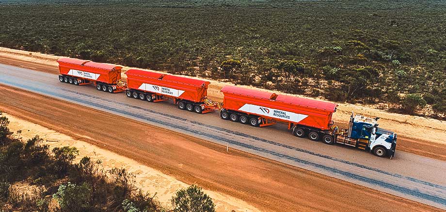
Hexagon AB, a provider of digital reality solutions, combining sensor, software and autonomous technologies, has announced an agreement with diversified mining company Mineral Resources (MinRes) to provide an autonomous haulage solution for a fleet of 120 fully autonomous road trains in Australia, which will transform safety, productivity and sustainability in the region.

The fully autonomous road trains are a full-site, truck-agnostic solution. The addition of unmanned and autonomous systems will form an essential part of the supply chain for the MinRes Onslow Iron project in Western Australia’s Pilbara region.

The centre of the autonomous platooning system is Hexagon’s autonomous solutions stack integrating drive-by-wire technology with an autonomous management system to orchestrate vehicle movement in road train haulage.

Mike Grey, Chief Executive, MinRes said, “Automation will remove the risk of driver fatigue, lower operating costs and reduce fuel use and emissions. There’s enormous potential for these vehicles to transform mining across the world.”

SkyWatch Announces EarthCache Enterprise

0
SkyWatch Announces EarthCache Enterprise

SkyWatch is known for launching the first API for commercial space data, allowing users to access an aggregate source of remote sensing data from the world’s leading providers. Now, SkyWatch’s EarthCache Enterprise solution allows organizations to unify all data assets, including new data sourced through EarthCache, existing data assets, and provider-direct data, into a consolidated user interface for company-wide access and analysis.

EarthCache Enterprise offers a robust feature set to help organizations manage and optimize the procurement and management of remote sensing data through the full data lifecycle, including:

  • Enterprise Archive which provides a fully-indexed, repository of all remote sensing data across the organization
  • DirectView, which provides one-click image sharing
  • Enterprise Analytics and Business Intelligence (BI)
  • User & Policy Management which allows administrators to enforce data policies and track project-level spending
  • Enterprise Analytics and Business Intelligence (BI)
  • Multi-source Data Access and Management
  • Professional Services
  • System Monitoring & Support

Forthcoming capabilities include SkyWatch’s upcoming semantic search and image classification product, which classifies and tags data in the Enterprise Archive using AI, and enables users to easily search with plain language terms.

“SkyWatch’s core mission is to make remote sensing data accessible, affordable, and standardized. Since we launched the market’s first API for commercial satellite data over five years ago, we’ve served millions of square kilometres of imagery to thousands of organizations worldwide,” says James Slifierz, SkyWatch’s CEO and Co-Founder.

“However, in solving one problem, we discovered another: in order for large organizations to efficiently use Earth observation data at scale, they need a solution that allows them to procure, manage, analyze, and share this data across thousands of employees. Our Enterprise offering results from an extreme dedication to solving our customers’ most pressing problems, and I couldn’t be more excited to announce it today.”

Teledyne Technologies appoints iMAGE S as Italian distributor

0
Teledyne Technologies appoints iMAGE S as Italian distributor

Teledyne e2v Space Imaging, part of Teledyne Technologies, has formally appointed iMAGE S as its Italian distributor with the objective of increasing its market share in Italy.

Headquartered in the region of Lombardia, Italy, iMAGE S was founded in 1994 as a point of reference for the industry of vision systems for applications in machine vision, artificial intelligence, industry 4.0 and the geospatial sector, offering to its customers the best skills and the most innovative technologies in the field.

Together, Teledyne e2v Space Imaging and iMAGE S will be working on joint Earth Observation programmes and scientific and exploration missions with the European Space Agency (ESA), Agenzia Spaziale Italiana (ASI), and privately operated commercial space programmes (new space).

Mark Bown, Head of Business Development for Europe, said:

“Working with iMAGE S we will grow our footprint throughout Italy and work together on upcoming Italian missions. The iMAGE S team will become an extension of the Teledyne e2v Space Imaging team.”

The partnership has recently marked an important milestone with the signature of a supply contract of high-performance CCD-on-CMOS image sensors for an important Earth Observation mission in Italy.

Teledyne e2v Space Imaging continues to grow its European team to provide space imaging solutions for European government and institutional collective projects.

Marco Diani, CEO, iMAGE S, added:

“We are proud of this new partnership with another company in the Teledyne group. We have been working with Teledyne DALSA since 1995 and together we have grown from strength to strength, delivering successfully to our strong portfolio of customers. With Teledyne e2v Space Imaging, we are sure that we will rise to the new challenges of the space economy.”

Timeline of India’s Satellite Launchers

Timeline of India’s Satellite Launchers

With new innovations, strategic planning, and the entry of private players in the fray, India’s spacing journey just seems to have entered a new transitory phase, as ISRO’s role evolves with time.

ALSO WATCH: All About ISRO’s Heaviest Workhorse that Lifted to the Moon

Stellantis, Samsung SDI to Build Gigafactory in the US

0
Stellantis, Samsung SDI to Build Gigafactory in the US

Stellantis, Samsung SDI Announce Plans to Build Gigafactory in the US

Stellantis N.V. and Samsung SDI announced that they have signed a memorandum of understanding to establish a second battery manufacturing facility in the United States, under the existing StarPlus Energy joint venture. Targeted to start production in 2027, the plant aims to have an initial annual production capacity of 34 gigawatt hours (GWh).

In May 2022, Stellantis and Samsung SDI announced their commitment to build a battery manufacturing facility in Kokomo, Indiana, U.S. Targeted to launch in the first quarter of 2025, the plant will have an annual production of 33 GWh, up from the initial target of 23 GWh.

“This new facility will contribute to offer at least 25 new battery electric vehicles for the North American market by the end of the decade,” said Stellantis CEO Carlos Tavares.

“By establishing the joint venture with Stellantis last year, we laid a solid groundwork for marking our presence in North America,” remarked Samsung SDI President and CEO Yoon-ho Choi. “The second plant will accelerate our market penetration into the U.S. and help Stellantis push forward the U.S. transition to an era of electric vehicles by supplying the products featuring the highest levels of safety and quality.”

As part of the Dare Forward 2030 strategic plan, Stellantis announced plans of reaching a 100% passenger car battery electric vehicle (BEV) sales mix in Europe and 50% passenger car and light-duty truck BEV sales mix in the United States by 2030. To achieve these sales targets, the Company is securing approximately 400 GWh of battery capacity. Stellantis is on track to become a carbon net zero corporation by 2038, all scopes included, with single-digit percentage compensation of remaining emissions.

Beyond Gravity to Provide Constellation On Board Computer to Quantum Space

0
Beyond Gravity to Provide Constellation On Board Computer to Quantum Space

Beyond Gravity to Provide Constellation On Board Computer to Quantum Space

Beyond Gravity, a supplier to the space industry, announced it will provide its constellation On Board Computer (cOBC) to Quantum Space’s inaugural flight of its Ranger multi-purpose vehicle, which will take payloads to geostationary and cislunar orbits.

The cOBC provides a host of functions including on-board processing, Global Navigation Satellite System (GNSS) receiver, ground communication as well as both platform and payload interfaces. In-space computing through the cOBC allows Ranger to process data and imagery more efficiently and comprehensively. The computer is fully redundant and offers flight-proven fault detection, isolation, and recovery (FDIR) as well as radiation mitigation to provide a highly reliable solution.

Thomas Badinand, sales manager, Beyond Gravity said, “We are seeing high demand in the market for the cOBC from both large primes and newer players. The computer is entirely based on commercial components, which results in much lower cost, shorter lead times, and higher performance.”

The cOBC is the central command and data handling unit designed for small to large satellites and available for very small to very large quantities. The cOBC for Ranger includes the MAX software suite from Rocket Lab, which is a comprehensive toolset including flight software, ground segment, and simulation. The cOBC is now being offered with the MAX flight software suite in collaboration with Rocket Lab as a standard offering.

“As Quantum Space continues to develop missions for GEO (geostationary Earth orbit) and cislunar space where independence from ground communications becomes more challenging, the need for robust and dependable avionics is paramount,” said Ben Reed, chief technology officer, Quantum Space. “Beyond Gravity has risen to this challenge with the development of its competitive, radiation-hardened, and reliable on-board computing technology.”

Precisely Selected as Exclusive Location Data Partner for Horizon Media’s Platform, blu.

0
Precisely Selected as Exclusive Location Data Partner for Horizon Media’s Platform, blu.

Precisely, a global company in data integrity, announced that it has been selected by Horizon Media, the largest U.S. media agency according to Ad Age Data Center 2023, as its exclusive movement and location data provider.

The partnership means that Precisely PlaceIQ data will be available directly from within blu., Horizon Media’s connected marketing platform.

blu. empowers brands to build deeper customer relationships by providing marketing practitioners access to real-world data and timely trends. By integrating Precisely PlaceIQ movement and location data directly within the blu. marketing platform, Horizon clients can connect online and offline activity for a new level of detail on what is driving consumers in the physical world.

The partnership means that Horizon’s clients across industries will have the data and analytics to unleash the power of location in their marketing strategies. For example, consumer packaged goods (CPG) clients can intersect purchase data with visitation data to understand shifting consumer channel preferences. Automotive clients can optimize “in-market” audiences based on where consumer footfall and location data show dealership visitation trends are strongest.

“This integration enables our agency teams and our brand clients to leverage location data in ways that would otherwise be impossible,” said Jean-Marc Papin, SVP Media Technology at Horizon Media. “The granularity of the Precisely PlaceIQ data, coupled with Precisely’s expertise in data integrity, allows our clients to build complex and innovative marketing campaigns with confidence.”

After an extensive evaluation, Precisely was chosen by Horizon Media to be its only location data partner.

“We’ve worked with Horizon Media for years developing location-based strategies to connect brands with consumers,” said Matthew Doherty, VP of Sales – PlaceIQ at Precisely. “What’s exciting about this partnership is that in making our data available in blu., we realize a new level of access and usability to enrich not just consumer touchpoints, but consumer-driven business decisions.”

Overture Maps Foundation Releases First World-Wide Open Map Dataset

0
Overture Maps Foundation Releases First World-Wide Open Map Dataset


The Overture Maps Foundation (OMF), a collaborative effort to enable current and next-generation interoperable open map products, announced the release of its first open map dataset.

The release includes four unique data layers: Places of Interest (POIs), Buildings, Transportation Network, and Administrative Boundaries.

These layers, which combine various sources of open map data, have been validated and conflated through a series of quality checks, and are released in the Overture Maps data schema which was released publicly in June 2023.

The Places dataset includes data on over 59 million places worldwide and will be a foundational element of navigation, local search and many other location-based applications.

Founded in December 2022 by Amazon Web Services (AWS), Meta, Microsoft, and TomTom, Overture today includes more than a dozen mapping, geospatial and technology companies, including new members ESRI, Cyient, InfraMappa, Nomoko, Precisely, PTV Group, SafeGraph, Sanborn, and Sparkgeo. The collaboration is based on the premise that map data needs to be a shared asset to support future applications. As the requirements for accuracy, recency and attribution in maps have grown to meet user needs, the costs and complexities of collecting and maintaining global map data have grown beyond the capability of any single organization.

“The Overture 2023-07-26-alpha.0 release is a significant step in establishing a comprehensive, market-grade open map dataset for our constantly changing world. The Places dataset, in particular, represents a major, previously unavailable open dataset, with the potential to map everything from new businesses big and small to pop-up street markets located anywhere in the world,” said Marc Prioleau, executive director of Overture Maps Foundation. “Anyone who works in mapping knows that the initial data is just the beginning; the ongoing challenge lies in maintaining the data amidst constant changes to meet user expectations. Overture plans to build a broad collaboration that can build and maintain an up-to-date, comprehensive database of POIs.”

In the new dataset, there are four unique data layers.

  • Places of Interest: OMF’s Places data layer includes over 59 million POI records that have not previously been released as open data. This dataset, derived from data contributed to OMF by founding members Meta and Microsoft, provides a significant baseline of worldwide places data. The Overture community will combine the best data from all available resources, including open government data, crowdsourced local mapping data, AI/ML techniques and more to improve, update and extend the data on an ongoing basis.  The Places dataset is licensed under CDLA Permissive v2.0, a permissive open data license and can be freely used by any map builders or location service providers.
  • Buildings: The OMF’s Buildings layer includes over 780M unique buildings footprints worldwide. This layer has been developed by combining various open data projects including OpenStreetMap, Microsoft AI-Generated building footprints and Esri.
  • Transportation: The OMF’s Transportation layer represents a worldwide road network derived from data in the OpenStreetMap project. This community-built data has been recast into the Overture data format which provides consistent segmentation of the data and a linear reference system to support additions of data such as speed limits or real-time traffic.
  • Administrative Boundaries: A global open dataset of national and regional administrative boundaries, this boundary data includes regional names which have been translated into over 40 different languages to support international use.

All data layers have been formatted in the OMF’s recently launched data schema, which is designed to allow map services developers to ingest and use map data in a standard, documented way and will be interoperable.

In Photos: Satellite Images Capture Wildfire in Greece

In Photos: Satellite Images Capture Wildfire in Greece
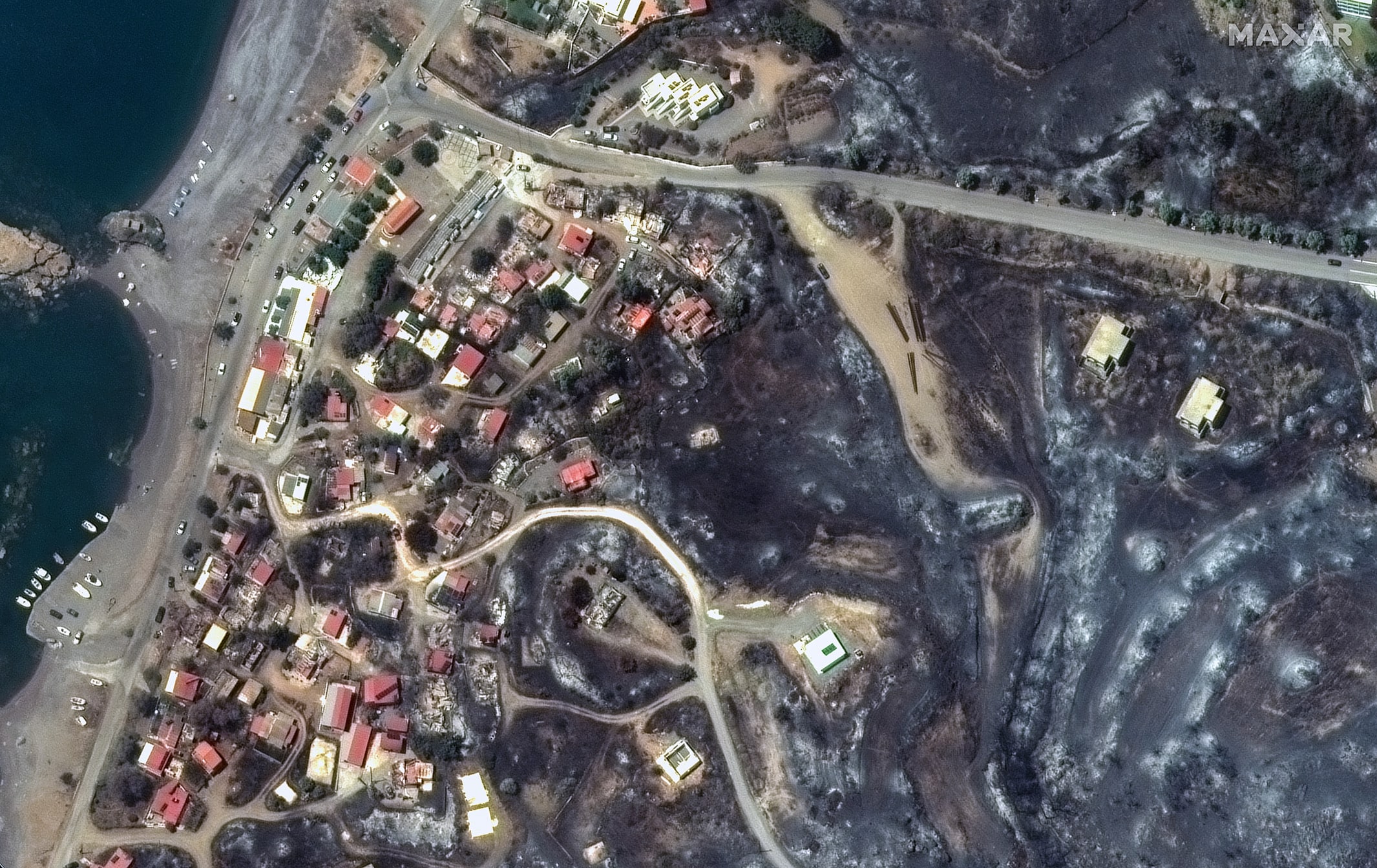
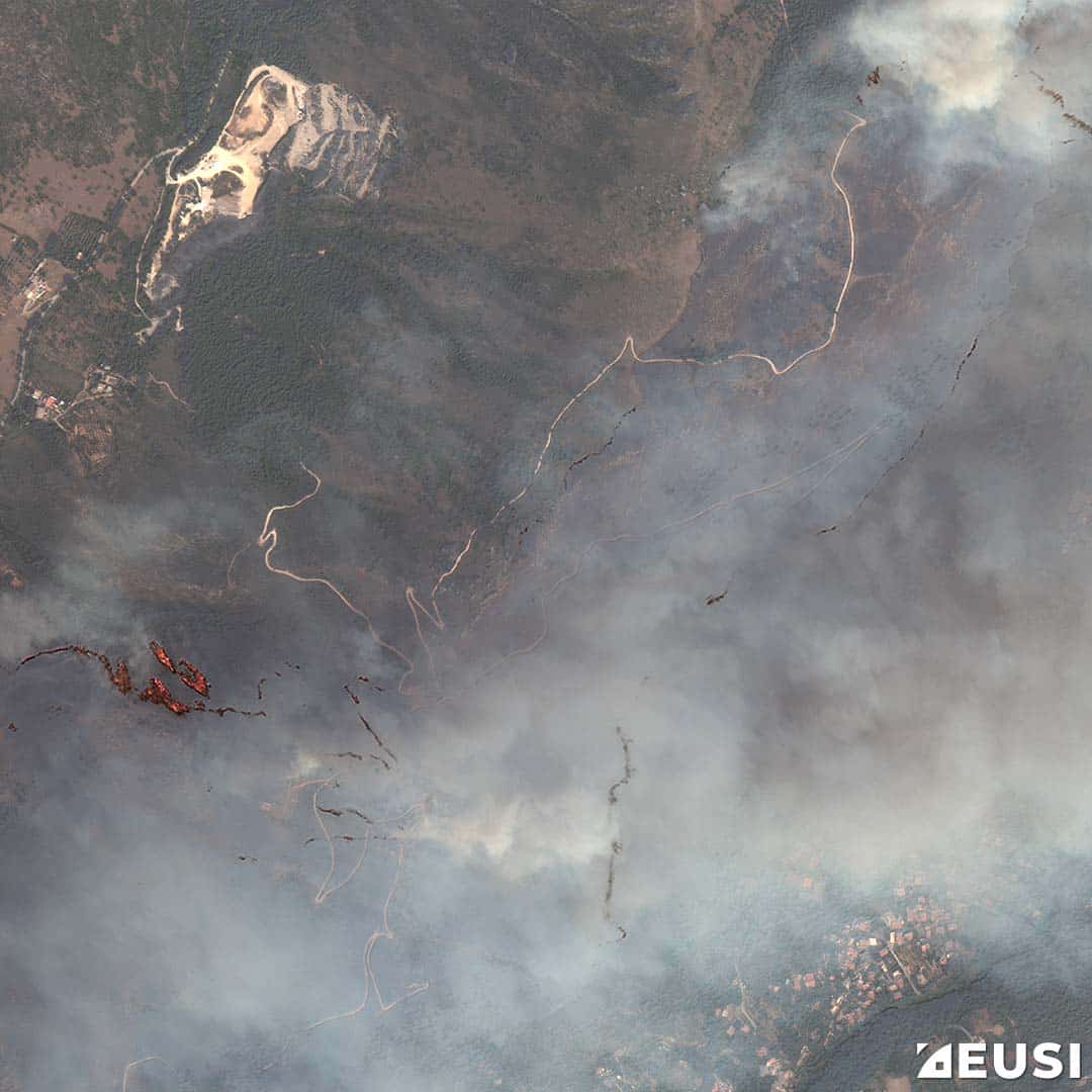
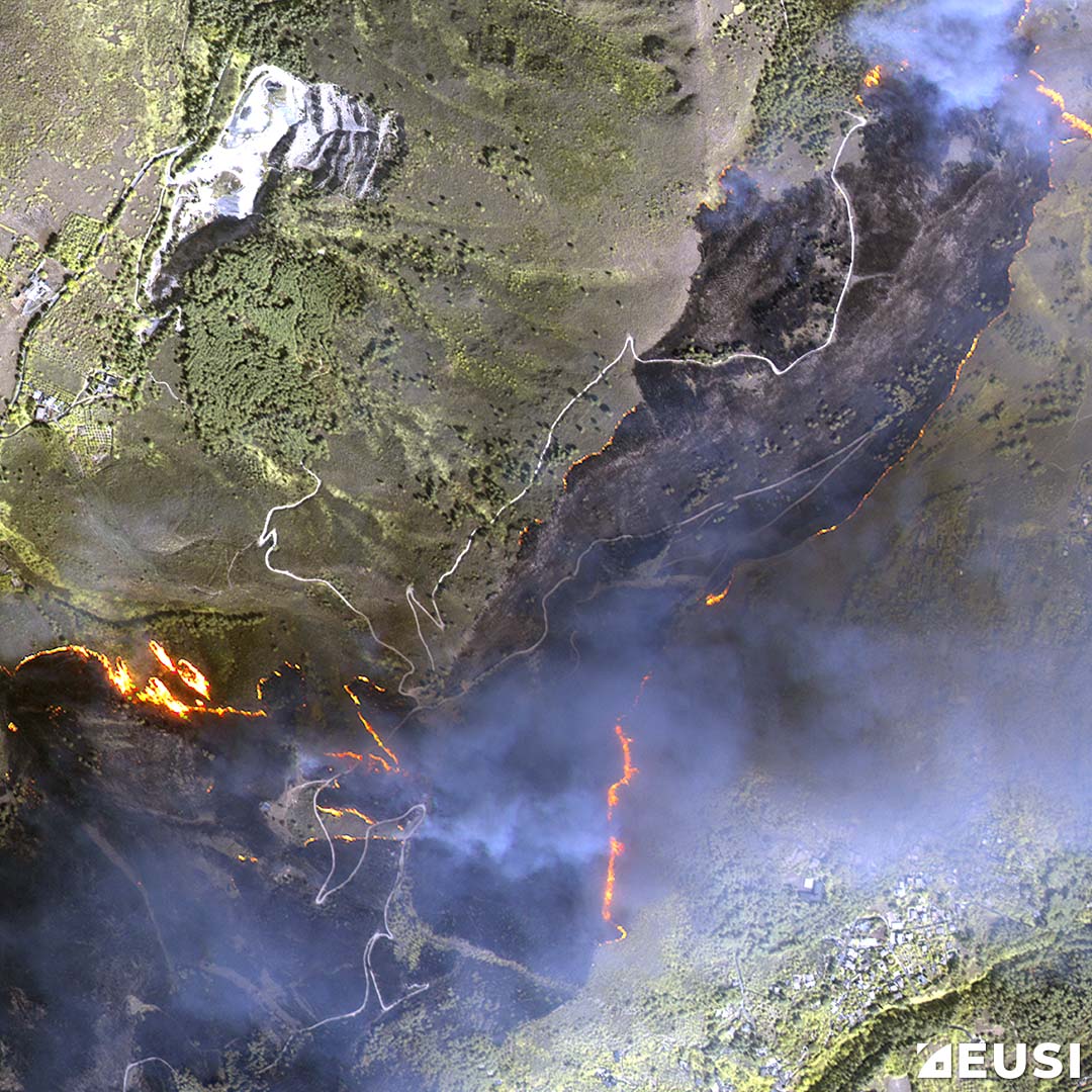
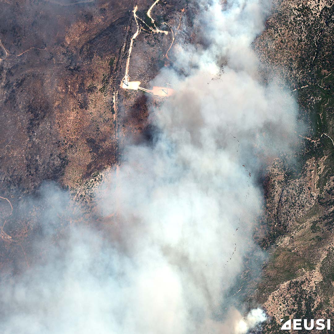
Sicily; Copyright: Satellite Imagery © Maxar Technologies Collected by European Space Imaging

Greece is burning for more than 48 hours. The wildfire has resulted in the loss of lives, which includes a plane crash that was fighting wildfires on the island of Evia. A fire brigade official informed that the fire affected around 10% of hotels in the southeast and central parts of the island. The evacuation process of tourists and residents by the sea is ongoing.

Rhodes has been the worst affected island of Greece, along with Evia, Athens, Aigio, and the island of Corfu (the most famous tourist destination in Greece), where emergency service providers are continuously engaged in fighting fire and providing rescue to people.

Prime Minister Kyriakos Mitsotakis said “We are at war” as the wildfire and intense heatwaves are burning the country. He warned of difficult days ahead and forced tourist evacuations, as Reuters reports.

The Civil Protection Ministry said Attica, the Peloponnese region, central Greece, western Greece, Thessaly, and some areas of central Macedonia are most at risk of fresh wildfires.

Greece has experienced the hottest July weekend in the past 50 years. In many parts, the temperature has exceeded up to 45 degrees Celsius.

Videos of terrible fires and black smoke are circulating online from many parts of Greece.

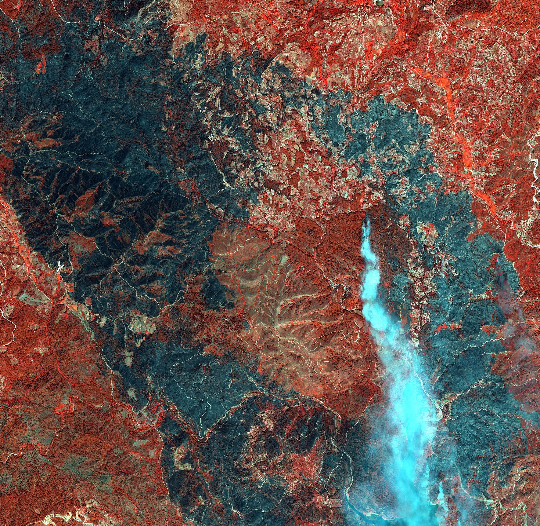
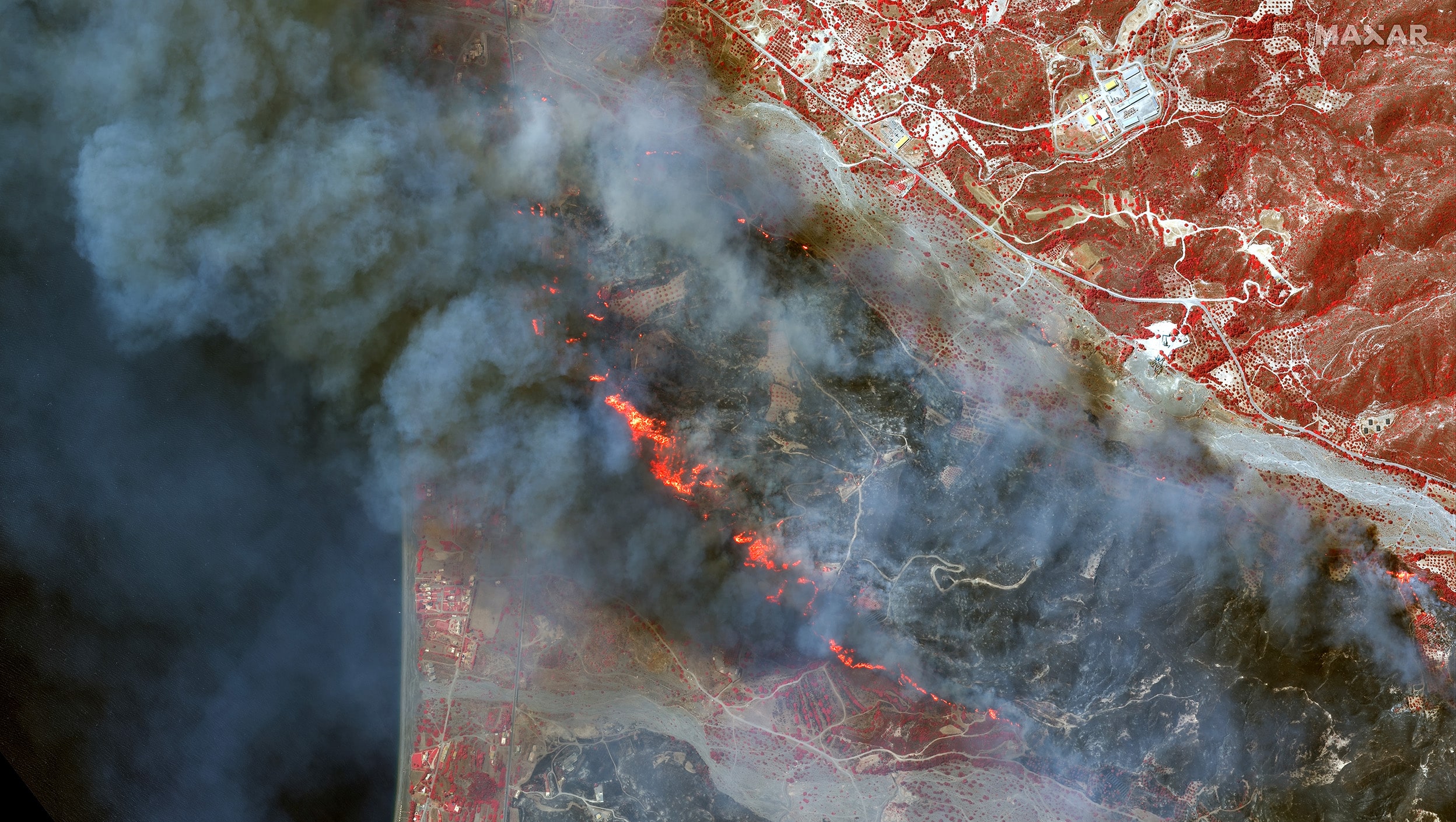
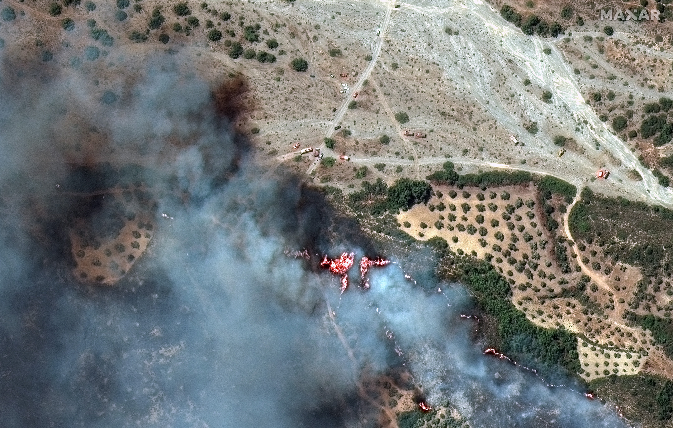
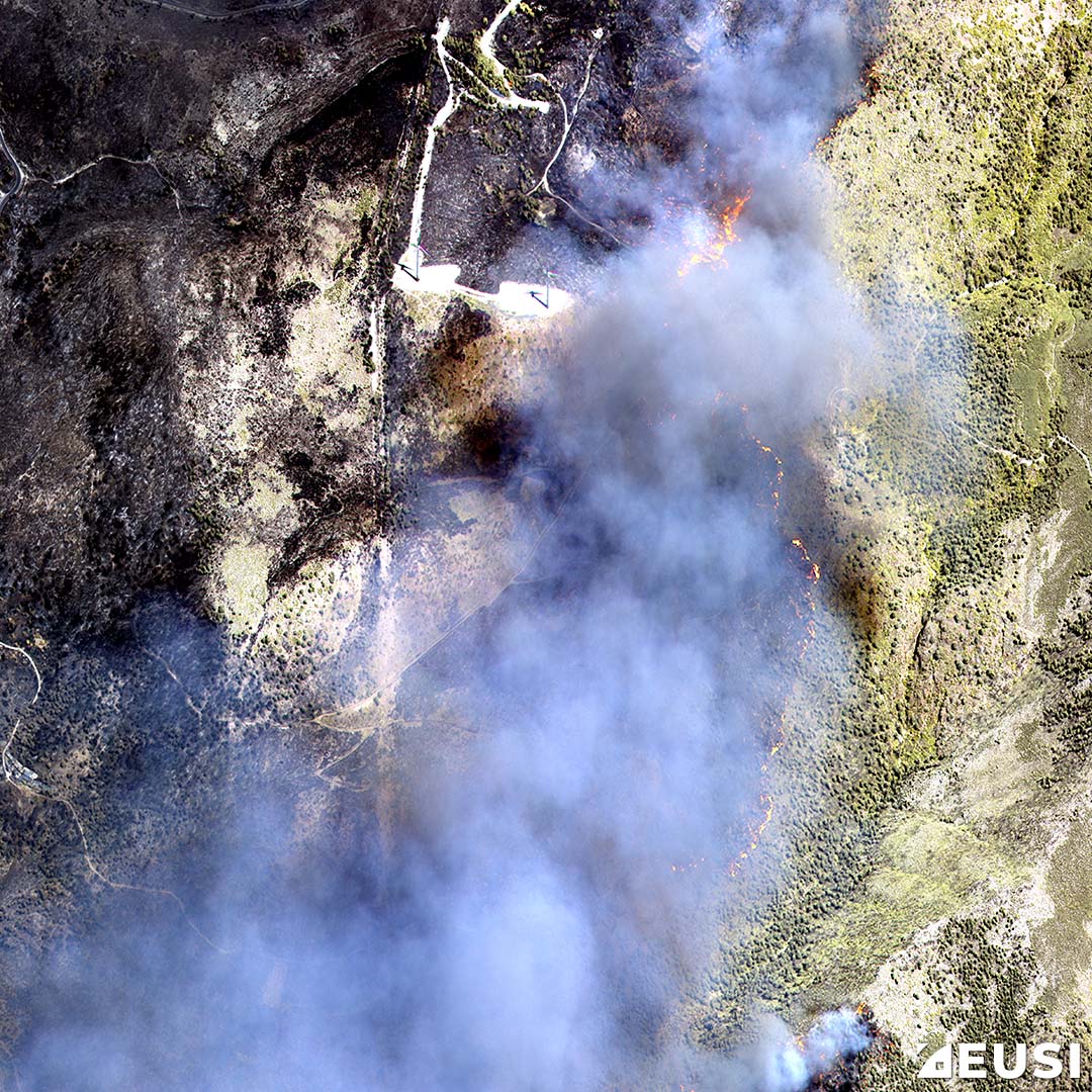
Maxar Technologies has shared satellite images of the wildfires burning across the island of Rhodes, Greece. These satellite images reveal that the most active fires are located along the southeastern coast of the island, near the town of Gennadi.

Satellite Imagery of 5 Mediterranean Fires

Here are the images (Healthy vegetation are shown in shades of red and burned areas in black/grey):

ALSO READ: July 3 World’s Hottest Day; El Niño Risks Climate Emergency

Betterview to Integrate EagleView’s Aerial Imagery into its Platform

0
Betterview to Integrate EagleView’s Aerial Imagery into its Platform

Betterview, the insurtech company Property & Casualty insurers rely on to identify and manage real property risk, and EagleView, a provider of aerial imagery and accurate property measurements, announced a strategic alliance. EagleView’s imagery will be integrated into Betterview’s property intelligence platform to help insurers better understand a customer’s total property risk by providing broader, data-driven intelligence for both underwriters and claims professionals. Additional benefits of the alliance will include the ability for EagleView customers to gain direct access to Betterview’s property insights, scores, and data.

Piers Dormeyer, CEO of EagleView said, “We’re launching an alliance that leverages the expertise of both companies to scale our innovative solutions and deliver unparalleled property intelligence to our customers.”

Customers across both product platforms will benefit from these advanced capabilities:

  • Greatly Expanded Imagery Coverage: Imagery coverage now encompasses 94% of the US population with over 1 billion ultra-high resolution property images.
  • AI Detections: Access to property condition attributes, including Roof Age, from the most advanced computer vision and machine learning in the industry.
  • Predictive Risk Scores: From roof conditions to weather-related perils and vulnerability, insurers will get the most accurate predictors of loss — pre-filled in many states.
  • Historical Image Library: Access to nearly 20 years of historical imagery will deliver expanded intelligence on property changes over time. A significant beneficiary will be Betterview’s new Roof Age product.
  • Rapid Post-CAT Event Imagery: When a storm strikes, EagleView mobilizes its fleet to capture imagery of the impacted areas, quickly producing before and after views of the event. This imagery will power Betterview’s CAT response solution, further supporting fast decisions and early assistance for homeowners.
  • Predictive CAT Response Capabilities: Customers will access solutions to remotely identify vulnerability, predict impact, quantify damage, and help homeowners recover faster from severe weather events.

The combined strength of EagleView and Betterview represents a major leap forward for insurance companies in their transition from repair and replace to predict and prevent.

Dave Tobias, COO and co-founder of Betterview said, “EagleView’s ultra-high-resolution imagery allows us to continue to develop the most accurate AI models, risk scores, and overall property insights. Ultimately, we can build the most innovative tools to solve tough problems for insurance.”

UK based Locana Supports OpenStreetMap Project

0
UK based Locana Supports OpenStreetMap Project

Locana, an international leader in spatial technology, is now a member of OpenStreetMap US, a nonprofit organization that helps support and grow the OpenStreetMap (OSM) project.

Conceived in 2004, OpenStreetMap is a free, open geographic database updated and maintained by a community of volunteers via collaboration. OSM broadens access to high-quality data, lowers the cost of harnessing location intelligence, and makes it possible for more organizations to take advantage of insights from location data. To date, OSM has been widely used by NGOs, humanitarian groups, and the scientific research community as a data provider for turn-by-turn navigation, disaster and pandemic response, education, and more. Many private organizations are starting to use OSM as well.

“Hundreds of millions of consumers today use services leveraging OpenStreetMap’s data, and organizational interest in deploying OSM data for business purposes continues to grow,” said Todd Slind, Locana Vice President of Technology. “We look forward to seeing OSM’s growing impact on consumers, and helping businesses take advantage of this open resource alongside other proprietary data sources to offer better products and services.”

For more than a decade, Locana’s team of experts has been actively involved in building OpenStreetMap by enriching data sets, making map information more detailed and accurate, testing new methodologies for generating location intelligence from OSM data, and contributing in other ways to the OSM community. Locana has also been a pioneer in demonstrating the value of OSM data by using it in innovative applications related to environmental protection, humanitarian aid, disaster response, education and much more.

In addition, Locana has successfully worked with companies to employ Esri software and open technology using OSM data. Locana has deep experience and technical expertise working with the data to understand how OSM can be programmatically manipulated, how OSM can be programmatically improved, and how OSM can be adapted to an organization’s requirements.

Pixxel wins Space grant to develop Miniaturized Multi-Payload Satellites

0
Pixxel wins Space grant to develop Miniaturized Multi-Payload Satellites
Pixxel plans to have its satellite constellation up in sky by 2022.

Pixxel, a hyperspectral earth-imaging technology has won a multi-crore grant from iDEX (Innovations for Defence Excellence under the Ministry of Defence) for the Mission DefSpace Challenge under iDEX Prime (Space), to manufacture miniaturized multi-payload satellites for the Indian Air Force.

Received as a part of the SPARK grants by iDEX, this grant will equip Pixxel to develop small satellites of up to 150 kgs for Electro-Optical, Infrared, Synthetic Aperture Radar and Hyper Spectral purposes; marking a significant milestone in Pixxel’s mission to revolutionize the space industry.

Pixxel has already solidified its position as a leading innovator in the space tech sector, building and launching made in India and the world’s highest-resolution commercial hyperspectral imaging satellites. Leveraging this indigenous technology and expertise that can enable ease of manufacture, low cost and ease of launch, Pixxel will now manufacture small satellites for the Indian Defense sector.

Commenting on this, Awais Ahmed, CEO, of Pixxel, said, “We are delighted to receive iDEX’s grant and utilize our expertise in building microsatellites in-house to manufacture satellites externally for the first time. This recognition highlights Pixxel’s dedication to pushing the boundaries of space exploration and innovation. We are grateful for the trust placed in us and excited to embark on this next phase of collaboration with the Indian government.”

Shri Vivek Virmani, Planning Officer, DDP/MoD & Chief Operating Officer, iDEX-DIO said: “We are delighted to witness the remarkable evolution of startups in the Indian space industry, and Pixxel is a testament to the progress of private entities in this sector in such a short time. The grant is aimed at developing technologies addressing every stage of a space mission, right from mission planning and manufacturing to satellite data analytics and more. Our confidence in Pixxel’s satellite manufacturing capabilities showcases the power of partnerships in advancing the use of satellite technology for the country. We congratulate Pixxel and look forward to working with them.”

The SPARK grants – offered to startups selected through the iDEX (Prime) & DISC initiatives are aimed at catalyzing innovation enabling Indian innovators and entrepreneurs to deliver technologically advanced solutions as well as propel deep-tech innovations in India.

Pixxel emerged as the winner of the grant from amongst a host of companies, owing to its pioneering technology in the area of hyperspectral satellite manufacturing.

As Pixxel sets out on its ambitious goal, the company remains steadfast in its commitment to advancing satellite technology, exploring new frontiers, and empowering industries across the globe.

Maxar to Begin Production of New Satellite Bus

0
Maxar to Begin Production of New Satellite Bus

Maxar Technologies, a provider of space solutions and secure, precise, geospatial intelligence, completed the first Critical Design Review (CDR) of the Maxar 300™ series bus for L3Harris Technologies in support of the Space Development Agency’s Tranche 1 Tracking Layer (T1TRK) program. The T1TRK program is designed to provide global warning and tracking of conventional and advanced missile threats, including hypersonic missile systems.

Maxar’s inaugural Maxar 300 series bus is designed for eight or more space vehicles per launch while delivering the demanding low jitter and high power required for the missile defense mission.

Chris Johnson, Senior Vice President and General Manager for Space at Maxar said, “We are on schedule to begin production of our platforms later this year with initial deliveries in early 2024. Our customers need speed and agility while ensuring a superior technical product, and that’s what Maxar’s commercial experience can deliver.”

The comprehensive review examined all the principal elements of the new system, including structural design, power, attitude control and command and data handling. Maxar will build 16 platforms for the T1TRK program, each about the width of a conventional oven. Those dimensions help the SDA achieve its goals to significantly reduce size, weight, power and cost compared to traditional missile detection satellites. The SDA mission will also adapt and extend Maxar’s deep commercial communications satellite experience for new uses.

Designed, engineered and built in-house in California, the Maxar 300 buses are modular platforms that benefit from the company’s decades of experience building more than 90 spacecraft for low Earth orbit. Both the platform and Maxar’s production capacity are scalable, with the ability to address multiple missions with flexible production rates that meet delivery timelines.

SoftBank Group & Symbotic Establish Warehouse-as-a-Service Joint Venture

0
SoftBank Group & Symbotic Establish Warehouse-as-a-Service Joint Venture

SoftBank Group and Symbotic, an A.I.-powered automation technology for the supply chain, announced the establishment of GreenBox Systems LLC, a new joint venture to address the more than $500 billion annual warehouse-as-a-service market opportunity.

Concurrently, Symbotic also announced an approximately $7.5 billion new customer contract with GreenBox, which will be the exclusive provider of Symbotic systems in the warehouse-as-a-service market and will make supply chain services available to customers.

GreenBox will automate supply chain networks globally by operating and making accessible Symbotic’s advanced A.I. and automation technology for the warehouse.

Symbotic’s A.I.-powered robotics and software technology will be the cornerstone of GreenBox, installed in single and multi-tenant facilities. The efficiency, SKU agility, scalability, and density of the Symbotic system allow GreenBox to effectively manage single and multi-tenant facilities across the supply chain and thus fundamentally reshape the economics of automated supply chain services.

Enabled by these technologies, GreenBox customers will be able to reduce inventory and costs while boosting SKU count and agility, all without associated capital expenditures and operational complexity.

“We are pleased to partner with SoftBank in this venture that accelerates our shared vision to transform the supply chain,” said Rick Cohen, Symbotic’s Chairman and CEO. “GreenBox enables Symbotic to bring the benefits of our technology to a broader customer universe, expanding our market opportunity.”

“GreenBox taps into the powerful potential of A.I. and other enabling technologies in supply chains, while also making the benefits of automation accessible to more businesses through an ‘as-a-service’ offering. In partnership with Symbotic, GreenBox will equip customers with more intelligent, streamlined, and scalable warehousing solutions while eliminating the burden of major capital expenditures,” said Vikas J. Parekh, Managing Partner at SoftBank Investment Advisers.

GreenBox will order Symbotic’s systems over a six-year period commencing in fiscal year 2024, to be implemented across its warehouse network in larger-scale deployments than Symbotic’s current installed base systems.

Optimizing Navigation in Southeast Asia with Localized Mapping

Optimizing Navigation in Southeast Asia with Localized Mapping

Grab, a prominent technology company in Southeast Asia, has developed its in-house mapping system called GrabMaps to provide efficient and accurate navigation for its services.

Challenges

This case study explores how GrabMaps overcomes the challenges of Southeast Asia’s unique local nuances that makes navigation difficult by collecting region-specific data, leveraging machine learning, and prioritizing user preferences.

The challenges faced are:

  • The lack of available suppliers for maps that could meet their specific requirements.
  • Third-party map providers often provided or offered generic data that did not account for the Southeast Asia region’s local nuances.

Solutions

Building Localized Mapping Data

In 2017, Grab’s Geo team made the strategic decision to develop its own maps for Southeast Asia by collecting and classifying mapping data in a local context. This included

  • Identifying and mapping small and narrow roads commonly used as shortcuts,
  • Capturing colloquial place names, and
  • Recognizing priority places such as prayer rooms that are essential for specific Southeast Asian countries.

Machine Learning for Continuous Improvement

Grab has developed country-specific machine learning models that are continually optimized to reduce inaccuracies and gaps in mapping data.

  • The system collects real-time feedback from driver-partners on the road, both manually and passively.
  • It monitors road closures based on driver feedback and recognizes patterns where multiple driver-partners avoid certain roads, indicating potential roadblocks.

Customized Routing and Point of Interest (POI) Identification

GrabMaps considers factors such as specific vehicle types and user preferences, to optimize routing and identify points of interest. For e.g., GrabMaps differentiates drop-off points for passengers and food orders from restaurants.

By capturing POI data directly, Grab ensures that its delivery driver-partners are routed to the correct locations, avoiding unnecessary detours.

The system also guides driver-partners to the appropriate parking spaces based on their vehicle type and provides visual cues, such as photos, to help them navigate to the closest entry point or pick-up desk.

Benefits

  • GrabMaps can adapt and update its data in realtime, providing reliable navigation information.
  • Maximize food and mart delivery opportunities and minimize wasted time for driver-partners.

ALSO READ: Streamlining Shopping Experiences with Indoor Navigation

Amazon invests $120 Million in Internet Satellite Facility in Florida

0
Amazon invests $120 Million in Internet Satellite Facility in Florida

Amazon has announced that it is investing $120 million in building a processing facility at NASA’s Kennedy Space Center in Florida for its thousands of planned Kuiper internet satellites, reported by Reuters.

The project Kuiper is designed to provide fast and affordable broadband globally, with a planned network of 3,200 low Earth-orbiting satellites.

The Kuiper internet network is expected to complement Amazon’s web services powerhouse. Amazon’s Kuiper satellites will launch from the Florida facility into space after being manufactured at the Kuiper project’s primary plant in Redmond, Washington.

The construction of the site began in January and plans to complete it by the end of 2024, said Steve Metayer, Amazon’s vice president of Kuiper Production Operations. The aim is to ship the first batch of satellites to the facility for processing in the first half of 2025, he added.

Impulse Space Secures $45M in Series A Funding Round

0
Impulse Space Secures $45M in Series A Funding Round

Impulse Space announced it has secured $45 million in its Series A funding round. The round is led by RTX Ventures, the venture capital arm of RTX.

“With the support from RTX Ventures, Impulse Space continues on the path toward its mission to provide agile, economic logistics services in any orbit,” says Impulse Space Founder and CEO Tom Mueller. “It speaks volumes that a leading investment firm is confident in the future of Impulse Space and its trailblazing technology.”

With an oversubscribed funding round, Impulse Space will be continuing its progress with its work in upcoming missions, such as LEO Express-1, a GEO refuelling mission and the upcoming mission to Mars.

Specifically, this funding will support the development of Impulse’s largest vehicle yet, called Helios. The Helios kick stage enables direct to Geostationary Equatorial Orbit missions, thus bypassing the need for a Geostationary Transfer Orbit.

“RTX Ventures invests in companies that we believe provide breakthrough technologies that disrupt aerospace, defence and commercial aviation sectors,” says President and Managing Director Daniel Ateya at RTX Ventures. “Our investment will help Impulse Space accelerate its growth and fuel innovation within the space economy.”

The Series A funding round also included other participant investors, such as Founders Fund, Lux Capital, Airbus Ventures and Space Capital.

INTERGEO 2023 – BIM in construction

0
INTERGEO 2023 – BIM in construction


Geodata is a fundamental part of the building information modelling (BIM) process and ensures planning and construction work is efficient, digital and sustainable. The importance of digital construction is highlighted by INTERGEO’s collaboration with the BIM Days Germany event, which is being held in parallel at the exhibition grounds in Berlin.

Building information modelling (BIM) remains a hot topic at this year’s INTERGEO EXPO and CONFERENCE. As in previous years, INTERGEO is addressing this topic in its role as the world’s leading platform for geodesy, geoinformation and land management. This year is the first time it is doing so in collaboration with the country’s largest hybrid event for digital construction – BIM Days Germany – which will have a dedicated exhibition area integrated into INTERGEO.

INTERGEO 2023 is the international platform for experts and decision-makers from the worlds of public administration, science, politics and business who use data, information and solutions from geo-IT sectors to carry out their work digitally, efficiently and sustainably. At the EXPO and CONFERENCE, INTERGEO will be revealing current trends and the latest developments from the geospatial industry, making the event this sector’s number one networking format for exhibitors and visitors from all over the world.

Staying competitive in times of crisis

The BIM Days Germany collaboration focuses additional attention on the hot topic of BIM. The programme of the 4th BIM Days Germany event includes innovations and solutions that companies throughout the construction industry’s digital value chain – including both new and existing buildings, infrastructure and smart cities – can use to boost their competitiveness, especially in times of crisis. The organisers are paying particular attention to implementation of the EU taxonomy for sustainable investments and to compliance with ESG (environmental, social and governance) criteria. How do BIM, IT, artificial intelligence and digital tools help with productivity and material cycles, where do the government and politicians need to support processes, and how can associations and institutions get small and medium-sized enterprises (SMEs) on board? These are the questions that are being addressed.

“Geoinformation is needed for BIM,” says Christiane Salbach, Managing Director of the German Association for Geodesy, Geoinformation and Land Management (DVW), which is hosting INTERGEO. “When it comes to developing cities and regions, the big picture is vital for designing these spaces. Digital twins of a smart city and BIM are the basic methods in this regard,” she continues.

“Our motto for this year – ‘Let’s build together’ – emphasises the fact that, even in Germany’s traditional and extremely heterogeneous construction industry, the only way to solve the acute challenges that exist is for us to work together,” says Dr. Josef Kauer, President of the BIM Days Germany organisation. “This collaboration with INTERGEO adds the vital dimension of geoinformation to BIM. That means we’re finally integrating geodesy as a key starting point for the digital construction value chain – especially when it comes to sustainable construction work on existing buildings,” he adds.

Geodata as the basis for BIM

Geoinformation is both the basis for, and a key component of, the building information modelling (BIM) process. To compile accurate information about the relevant site, building or infrastructure, the surrounding area needs to be surveyed and the details recorded before a construction project starts. In the case of construction projects involving existing buildings, the survey of the buildings themselves is vitally important (Scan2BIM). This data is then integrated into a BIM model to enable accurate 3D modelling of the planned project.

INTERGEO 2023 will offer visitors the opportunity to find out about the latest BIM trends and innovations and talk to industry experts. The EXPO is showcasing a wide range of solutions and products covering the entire BIM process – from planning, design and construction all the way through to maintenance, building operation and infrastructure projects.

Further focal points of INTERGEO

Besides the focal point of BIM, INTERGEO 2023 is also offering a wide range of topics relating to geodesy, geoinformation and land management. The EXPO will include stages, areas for start-ups, a Flight Zone for drones, and presentations by experts and industry leaders on topics such as geodata infrastructure, satellite and aerial photography technology, surveying, mapping and geoinformation systems. Given the global changes to our environment and climate, a considerable amount of space is being devoted to global monitoring of the Earth using satellites and ground, air and water-based sensors.

The CONFERENCE is the platform for first-class information and discussions involving international speakers and experts. Topics will include smart cities, digital twins, high-precision positioning, smart mapping, property valuation and much more besides. At the CONFERENCE, too, BIM and Earth observation will enjoy extensive coverage.

INTERGEO 2023 will also offer numerous networking opportunities – for start-ups, students, managers and decision-makers from the user industries.

Berlin is waiting for you!

Discover the latest technologies and applications at first hand and let yourself be inspired by the diverse exhibitors.

This year’s INTERGEO EXPO and CONFERENCE is taking place in Berlin from 10 to 12 October. The BIM Days Germany will offer additional exhibitions and events on the BIM stages on 11 and 12 October and will conclude on 12 October with the BIM Capital Congress, including an evening reception at the AXICA event location next to the Brandenburg Gate.

Cloudeo, Spire Global partner to bring Weather Data to Geospatial Experts

0
Cloudeo, Spire Global partner to bring Weather Data to Geospatial Experts

Cloudeo, Spire Global partner to bring Weather Data to Geospatial Experts

Cloudeo, geospatial data and solutions platform, has partnered with Spire Global, a provider of space-based data, analytics, and space services, to bring weather data to over 34,000 GIS and Earth Observation experts from around the world.

Spire Global builds, owns, and operates a fully deployed satellite constellation that observes the Earth in real time using radio frequency technology. Spire’s radio occultation (RO) technology processes over 20,000 atmospheric readings daily and has been trusted by weather service providers such as ECMWF, NOAA, and NCAR.

Spire Global will be the exclusive weather data provider on Cloudeo’s platform, bringing AIready historical, current and 15-day weather forecast data sets. Satellite-powered weather data enables GIS experts to perform spatial analysis, emergency management, environmental studies, urban planning, natural resource management, among other decision-support utilities. Spire’s listing on Cloudeo’s marketplace will encompass a wide range of weather datasets, including maritime, soil moisture, historical weather and more.

Mike Eilts, General Manager of Weather and Earth Intelligence at Spire Global said, “By combining our weather and satellite expertise, resources, and networks, we can offer integrated solutions that address specific industry needs, reaching new markets and customers.”

The partnership between Spire Global and Cloudeo creates numerous opportunities for growth and continued innovation in the industry by allowing:

  • Expanded Data Access: The partnership will lead to expanded access to satellite-powered weather data.
  • Enhanced Data Analytics: Collaborations between Spire Global and cloudeo’s partners specializing in data analytics and Earth Observation can result in more advanced and refined analytical tools.
  • Improved Data Processing and Delivery: Partnerships such as this can streamline data processing and delivery workflows. This allows for quicker access to up-to-date information, benefiting various industries and applications.

This announcement comes in light of the growing demand from scientists, policymakers, and researchers for more accurate and reliable data to make better-informed decisions. This partnership will pave the way for researchers and commercial entities to build better decision-support products, particularly when integrated with other Earth Observation data.

Evolving Supply Chain Management in Retail

Evolving Supply Chain Management in Retail

Supply chain management is a crucial aspect of the ever-evolving retail industry. Due to the massive disruptions caused by the recent pandemic, there has been a noticeable shift in supply chain management – from traditional, centralized models to more decentralized and agile networks.

To meet customer demand and to stay ahead of the competition, retailers need to have complete visibility of their supply chain network. This can be achieved by leveraging technologies such as Artificial Intelligence (AI), Machine Learning (ML), Internet of Things (IoT), and Blockchain.

“Retailers are leveraging data to improve operations and offer a more personalized experience for customers,” Alan Boehme, CTO, H&M Group, Sweden said in a podcast.

“For example, if a shopper picks up a garment in the front of the store and takes it to a fitting room in the back of the store, we actually can see that garment moving and we can create brand new customer experiences or predict based on their purchase history or predict based on what they’ve picked up.”

By adopting these innovative technologies, retailers can achieve a higher level of efficiency and responsiveness in their supply chains. They can effectively monitor the location and condition of goods, optimize inventory levels, and ensure seamless transportation. Furthermore, these advancements enable retailers to forecast demand more accurately and make informed decisions, empowering them to meet customer expectations and maintain a competitive edge.

Here’s how geospatial and location play a role in supply chain management:

Warehouse & Inventory Management

With the growth of e-commerce, lack of clarity on stock levels and incorrect data on availability could lead to bottlenecks and delays in delivery. Geographic Information System (GIS) enables retailers to visualize all parts of their supply chain, from warehouse to transportation assets, and down to store inventory, all in one platform.

Indoor mapping of an entire warehouse can significantly improve stock visibility and the order picking process. With the help of AI, orders can be clustered logically, which helps optimize picking routes by warehouse employees. Such integrated, intelligent task planning also optimizes workload distribution for employees and helps prioritize more time-critical shipments. Similarly in a superstore, restocking shelves, finding and returning misplaced products, and tracking inventory levels are challenging tasks for store employees.

An integrated system of indoor positioning, IoT sensors, robotic scanners, and AI can be trained to detect items on the shelves, recognize the specific product types, and compare the quantities on the shelves to the predicted sales demand. The system then automatically triggers out-of-stock notifications to internal apps that alert store employees to re-stock particular items.

In the future, the current 2D capability will be further refined and replaced with 3D. “The advent of Augmented Reality (AR) will drive a nascent need for 3D data to map complex building structures, from the warehouse to the mall and down, one day, to the aisle and the shelf, in the store,” says Nick Zabikow, Senior Director of Sales, Logistics and Technology, HERE Technologies, USA.

Demand Prediction

Demand prediction helps retailers minimize stockouts, reduce excess inventory, and most importantly, ensure customer satisfaction. “Location data was not commercially available before 2015. So one of the most powerful recent capabilities is the creation of a historical database, i.e. the ability to monitor the change in consumer behavior over time,” says Yiannis Tsiounis, Ph.D., Executive Chairman, Advan Research, USA.

On top of historical sales data, customer behavior analysis, and market trends; special events such as holiday seasons and weather patterns also affect demands. Analyzing such data in a GIS can ensure accurate demand prediction by store location.

Another parameter that can be used to understand demand patterns, especially for supermarket chains, is the number of cars in the parking lots. Using archived high-resolution satellite data, automobile counts can be collected accurately and at the same time on specific days. When combined with other data, it can provide valuable snapshots of monthly sales activity at individual stores or trends among retail locations.

Shipment Tracking

Order fulfillment and shipping are the most critical components for retailers as they impact customer retention and profitability. Real-time shipment tracking utilizes GNSS-enabled telematics devices or Radio-frequency identification (RFID) tags, combined with logistics databases, to determine the position of any package at any moment in time.

Whenever a parcel is scanned, it gets assigned to a vehicle or a dispatcher, which position is constantly monitored via mobile devices. Such real-time location updates allow retailers to gain immediate visibility into the location, condition, and availability of products throughout the supply chain. Consequently, offers a more transparent delivery information to consumers.

“With better precision in tracking, routing algorithms will evolve; also using more and more complex datasets, the technology trends of routing, ETA calculations will move towards predictive analytics, helping a retailer and its operations centers be more proactive,” adds Zabikow.

Last-Mile & Hyperlocal Delivery

Last-mile delivery is a critical component of the entire retail supply chain. The goal of last-mile delivery is to deliver orders to consumers as quickly as possible.

Location Intelligence can help retailers reorganize information into its route planning algorithms or by reconfiguring distribution services for specified consumers’ locations. An efficient last-mile delivery will not only increase productivity but improve customer satisfaction and loyalty.

“Previously, people needed to travel to retail locations, whereas with the new trend, businesses now can rely on dark stores, logistics-wise optimized locations for effective shipments. Therefore address handling, geocoding, routing and optimization for deliveries are now more critical,” says Alim Küçükpehlivan, CEO, Basarsoft, Turkey.

Having a route optimization software powered by geospatial technology will help delivery drivers/riders determine the best routes to take based on real-time updates on traffic conditions, roadblocks and other incidents on the road. This capability will enable faster deliveries, save fuels and more profit as more deliveries can be made within a day.

The system can also be used to analyze late deliveries. By correlating delivery times and delays with variables such as building type, access type, and parking facilities, a new layer of delivery intelligence can be created on top of location data.

“In India, increasingly retail delivery and deliver-to-consumer location are becoming popular. All segments of retail are witnessing huge appetite for location intelligence. In addition to aggregators like Zepto, Swiggy, Instamart, Dunzo, BlinkIt, and Big Basket, big consumer brands and retail companies are also directly delivering to the customers through delivery/courier partners,” shares Aswani Akella, Founder, LatGeo Consulting, India.

“From urban areas, the services are now migrating to tier-2, tier-3 towns and rural areas. Interestingly, hyper-localized services and solutions are manifesting a behavioral shift in consumption patterns triggering demand for predictive and prescriptive analytics,” he adds.

In addition, many businesses across various industries use geocoding, which is converting street addresses into geographic coordinates. There has been a transition from range interpolation geocoding, which assumes locations for certain establishments, to Rooftop Geocoding, which indicates the exact location of the structure.

“This shift has resulted in greater location accuracy, leading to significant benefits for businesses,” says Jan Kestle, President and CEO, Environics Analytics, Canada.

In recent years, retailers such as Walmart, Amazon, and Domino’s Pizza have tested the use of automation for last-mile delivery. This includes drones, autonomous vehicles, and robots. Such unmanned and contactless deliveries require accurate geospatial and location capabilities to ensure delivery safety and efficiency.

ALSO READ: Location Intel for Marketing

Remote Sensing and Its Evolution

Remote Sensing and Its Evolution
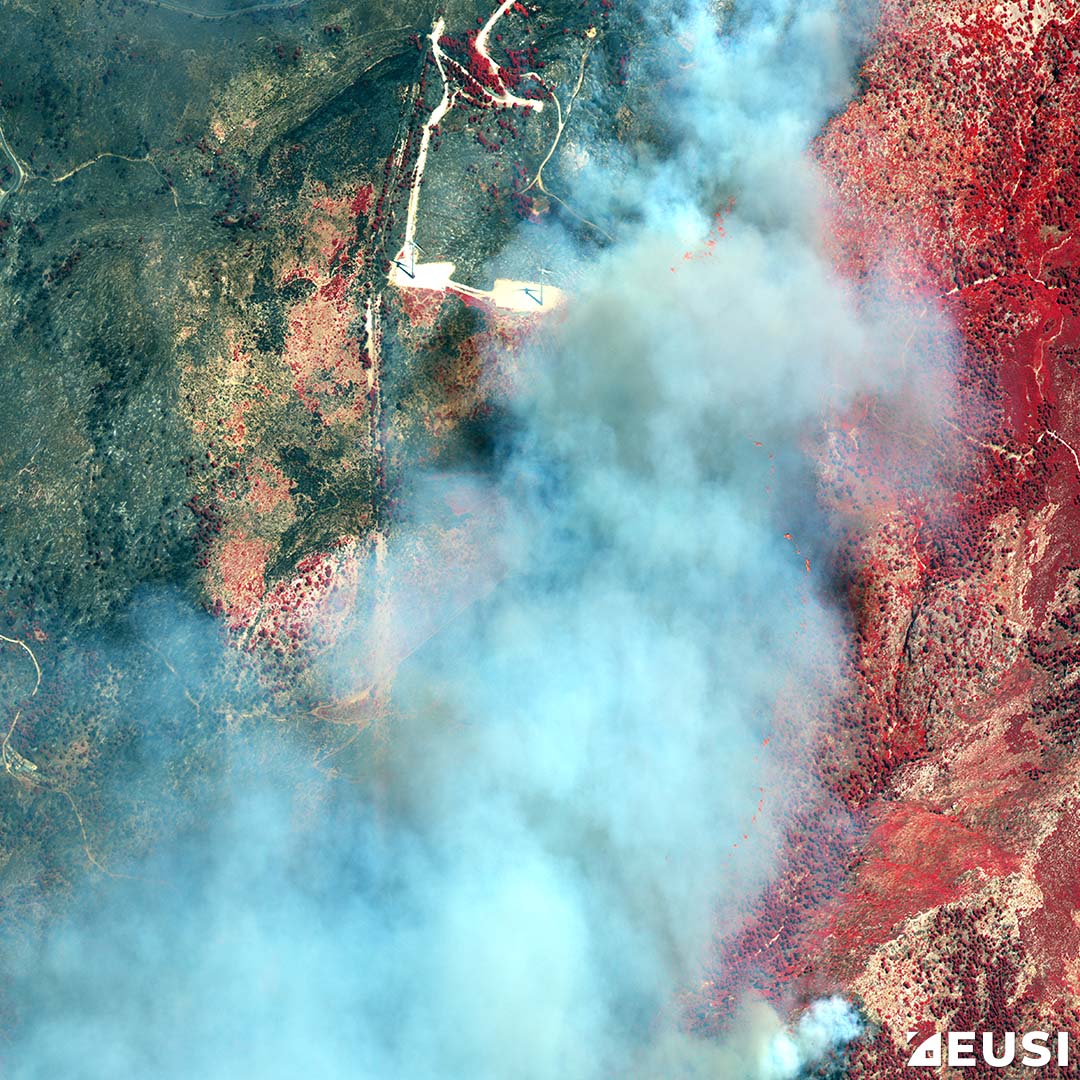
Remote sensing is one of the types of geospatial technologies used for data collection in the form of imagery from space or UAVs and sensor platforms. It supports the collection of detailed multispectral data that has led to a better understanding of minerals, soils, urban development, agriculture, and other geographic features.

What is remote sensing and how does it work? 

Remote sensing can be defined as the process of acquiring information about an object from a distance. These sensors detect and monitor electromagnetic radiation, being reflected from Earth in the form of visible wavelengths radiated, reflected or scattered, ultraviolet, microwave, and infrared wavelengths. Here are some examples:

  • Remote sensing helps to track the growth in urban areas.
  • Changes in forests or farmland over several years can be monitored.
  • Forest fires can be mapped through satellite cameras by using remote sensing technology.
  • Helps to predict the weather or monitor volcanic eruptions

What are the types of remote sensing? 

Remote sensing is classified into two types:

Active Remote Sensing

Active sensors use their own emission source or light to illuminate the object and measure the distance. An example of this is the camera that we use to take pictures. When the flash is used, cameras act as active sensors. They illuminate their target and measure the reflected energy back to the camera. Active sensors are needed to capture the images under the shade.

There are different types of active sensors such as:

  • Radar
  • LiDAR
  • Sounder
  • Scatterometer
  • Laser altimeter
  • Ranging instruments

Passive Remote Sensing

Passive sensors do not emit energy; they rely on solar light to illuminate the object. That is why these sensors only be used with proper sunlight; otherwise, there is nothing to reflect. These passive sensors cannot operate in bad weather conditions. It is impossible for passive sensors to quantify plant structure under a canopy, as sunlight is typically reflected from the top of a forest.

The following are the common types of passive sensors:

  • Spectrometer
  • Radiometer
  • Spectroradiometer
  • Accelerometer
  • Hyperspectral radiometer
  • Imaging radiometer 

Why is remote sensing important?

Remote sensing is one of the most advanced technologies for planning and management. It provides the latest information about any object located at a great distance. Applications of remote sensing are used in the development processes such as soil, forestry, geology, and agriculture. It is used for sustainable development, disaster management, environmental degradation, and natural resource management.

How is remote sensing evolving with the advancements in technology? 

With advances in drone and robotic technologies, remote sensing is also evolving. The use of these platforms complements traditional platforms and provides more accurate insights.

These technologies have opened up a new class of use cases that were not possible with traditional aerial survey methods. They provide new opportunities for monitoring remote areas, and their form factor and cost enable a higher frequency of data collection.

Drone and robotic technology platforms can be used for remote sensing in various fields such as energy, forestry, oil and gas, transportation, aviation, emergency management, and natural resource restoration and conservation. The frequency of data from these platforms is combined with analytics and cloud infrastructure, to acquire, analyze and act upon in more effective ways.