Home 2023 July

Monthly Archives: July 2023

AutoFlight Makes World’s First Flight of Three Autonomous eVTOL Aircraft

0
AutoFlight Makes World’s First Flight of Three Autonomous eVTOL Aircraft

AutoFlight, an autonomous electric vertical takeoff and landing (eVTOL) technology, successfully executed a world-first formation flight of three autonomous eVTOL aircraft in Shanghai, China.

Three of AutoFlight’s industry-leading “Prosperity I” models were involved in the groundbreaking flight, demonstrating the company’s capability in rapid prototype design, manufacturing, and its ambition to shape the future of aerial transportation.

“We aim to complement urban and regional means of transport for all people by building very safe, quiet, and affordable air taxis,” says Tian Yu, Founder of AutoFlight, who has decades of experience developing and delivering remotely piloted aircraft at an immense scale.

Lukasz Gadowski, technology entrepreneur, investor, and backer of AutoFlight, adds, “It is a delight to be part of a venture that’s reshaping the frontiers of technology and innovation. With this successful flight, we have set a new standard for the eVTOL industry.”

The company, with dual headquarters in Augsburg, Germany, and Shanghai, China, previously achieved a world record flight in February 2023 where one of their prototypes covered 250 km on a single battery charge, demonstrating the potential for sustainability in the sector.

The historic formation flight saw three generations of the “Prosperity I” aircraft, indicating the rapid evolution of the aircraft’s development. The company plans to make the prototypes into products, with a cargo version set to be released for safe cargo transport in Asia next year, and a passenger version gradually developed in the coming years, meeting the highest safety standards for aviation.

“The formation flight is a testament to our commitment towards making aerial transport safe, sustainable, and accessible,” says Mark Henning, former Airbus Helicopter Engineering Chief and head of the AutoFlight Europe team. “We have much more to come.”

Wisk Aero Completes Public Demo of Fully Autonomous eVTOL Taxi

0
Wisk Aero Completes Public Demo of Fully Autonomous eVTOL Taxi

Wisk Aero Completes Public Demonstration Flight at EAA AirVenture

Wisk Aero, a leading Advanced Air Mobility company, has successfully completed the world’s first public demonstration flight of a fully autonomous, electric vertical takeoff and landing (eVTOL), fixed-wing air taxi. The milestone flight, which took place at EAA AirVenture, also marked the company’s first public demonstration of its 5th Generation autonomous, eVTOL technology demonstrator (Cora).

Wisk completed a multi-transition flight, during which the air taxi transitioned from hover to wing borne flight four times. The flight also included multiple maneuvers that demonstrated the unique capabilities of the aircraft, such as hover, 360-degree turns in place, and more. Video footage of the flight can be found on Wisk’s YouTube channel.

Brian Yutko, CEO of Wisk said, “This demonstration showcases the state of readiness for autonomous technology and electric propulsion. Combined with the progress we’re making on Type Certification for our 6th Generation air taxi, we’re proving that autonomy is possible and it’s happening today. We look forward to launching the first passenger service on an all-electric, autonomous air taxi within this decade.”

Wisk’s public demonstration flight adds to the company’s history of aviation firsts, including the world’s first full transition of an eVTOL aircraft (1st Generation air taxi), the world’s first piloted flight of a fly-by-wire, all-electric, human-rated aircraft (2nd Generation air taxi, 2015), the world’s first piloted full transition flight of a human-rated eVTOL aircraft (3rd Generation air taxi, 2017).

Geospatial intelligence startup Kleos Space files for bankruptcy

0
Geospatial intelligence startup Kleos Space files for bankruptcy

Kleos Space, a Luxembourg-based startup that operates signals-intelligence satellites, has run out of cash and will file for bankruptcy.

The company’s financier on July 25 informed Kleos Space that it will no longer extend additional credit, a spokesman for Kleos Space, Lou Weis, said on July 26 in a statement to SpaceNews.

Kleos Space’s financing has been run by Pure Asset Management, an Australian investment firm. Kleos Space today notified the Australian Securities Exchange it plans to file for bankruptcy after failing to raise more money.

The company earlier revealed it had problems with a couple of the satellites it had launched and had to write them off.

The company suffered a series of setbacks due to space launch delays, and satellite development issues, and faced challenges accessing capital.

L3harris completes Acquisition of Aerojet Rocketdyne

0
L3harris completes Acquisition of Aerojet Rocketdyne

L3harris completes Acquisition of Aerojet Rocketdyne

L3Harris Technologies, specializing in surveillance solutions, microwave weaponry, and electronic warfare, has completed its acquisition of Aerojet Rocketdyne, a world-recognized aerospace and defense leader, forming a fourth business segment at the company.

L3Harris signed a definitive agreement to purchase Aerojet Rocketdyne in December 2022, emphasizing its ability to strengthen the defense industrial base, enhance competition and accelerate innovation for a critical merchant supplier of propulsion systems.

Christopher E. Kubasik, Chair and CEO, L3Harris said, “With national security at the forefront, we’re combining our resources and expertise with Aerojet Rocketdyne’s propulsion and energetics capabilities to ensure that the Department of Defense and civil space customers can address critical mission needs globally.”

The company also announced Ross Niebergall will serve as President of the Aerojet Rocketdyne segment at L3Harris.

“Our customers demand a competitive environment that produces innovative, agile solutions,” Niebergall said. “We will expand on the strong Aerojet Rocketdyne heritage to enhance production and deliver on those expectations.”

The acquisition diversifies the L3Harris portfolio, adding considerable long-cycle backlog and broad expertise that enables opportunities in missile defense systems, hypersonics and advanced rocket engines, among other areas.

SpaceX Falcon Heavy launches heaviest commercial communications satellite

0
SpaceX Falcon Heavy launches heaviest commercial communications satellite

SpaceX Falcon Heavy rocket launched EchoStar, a powerful new communications satellite that will deliver broadband service across nearly 80% of North and South America.

The Falcon Heavy’s first stage, made up of three strapped-together Falcon 9 boosters, roared to life with a sky-lighting burst of flaming exhaust at 11:04 p.m. Eastern time.

The Jupiter 3 satellite’s onboard thrusters will circularize the orbit at an altitude of 22,300 miles above the equator at 95 degrees west longitude.

Jupiter 3, a.k.a as EchoStar 24, is the heaviest commercial communications satellite ever launched. With solar panels stretching 127 feet from tip to tip, the satellite will provide broadband service through EchoStar’s subsidiary, Hughes Network Systems. Xplorenet Communications, a long-time Hughes partner, will provide service across Canada.

EchoStar’s satellites represent an alternative approach to space-based internet, using a few, very powerful high-altitude data relay stations.

The low-altitude systems provide high speeds and low latency, passing off a user’s internet activity from one satellite to another as they streak overhead. Geosynchronous satellites are much farther away and signals take longer to traverse the distance. But no handoffs are required and multiple beams deliver relatively fast service to high-demand areas.

Semtech Integrates UnaBiz’s Sigfox 0G Technology to its Platforms

0
Semtech Integrates UnaBiz’s Sigfox 0G Technology to its Platforms

Semtech Integrates UnaBiz's Sigfox 0G Technology to its Platforms

Semtech Corporation, a high-performance semiconductor, IoT systems and cloud connectivity service provider, announced it is collaborating with Massive IoT service provider and integrator UnaBiz, to enable Sigfox 0G technology on Semtech’s LoRa Edge™ and the next-generation LoRa Connect™ platforms.

This collaboration will enable customers to develop solutions that combine LoRaWAN® and Sigfox 0G technologies, providing global coverage for more IoT use cases such as asset management through ultra-low power geolocation in industries including supply chain and logistics.

Semtech’s LoRa technology, with its long range, low power and secure communication capabilities, has emerged as the de facto IoT platform for private LPWAN IoT applications. LoRa Edge and the LoRa Connect transceivers offer radio performance with highly desirable features such as multi-band connectivity, ultra-low power Wi-Fi and GNSS scanning capabilities in a single monolithic silicon, making them highly cost-effective platforms for IoT and geolocation applications in the global unlicensed LPWAN market, ensuring wide coverage. This collaboration paves the road for LoRa Cloud™ geolocation on the Sigfox global 0G network, currently present in over 70 countries. Simplifying IoT deployments and enhancing global availability based on the combined network’s coverage will enhance the options and opportunities for developers to create world-class solutions.

UnaBiz joined the LoRa Alliance® as a Contributor member recently following a series of partnership announcements with several LoRaWAN ecosystem members. In April 2023, UnaBiz opened up the Sigfox device library to the public and IoT community to build bridges with all IoT communication technologies and power sustainable business growth. The open device library facilitated the validation of the Sigfox 0G technology with the LoRa Edge platform.

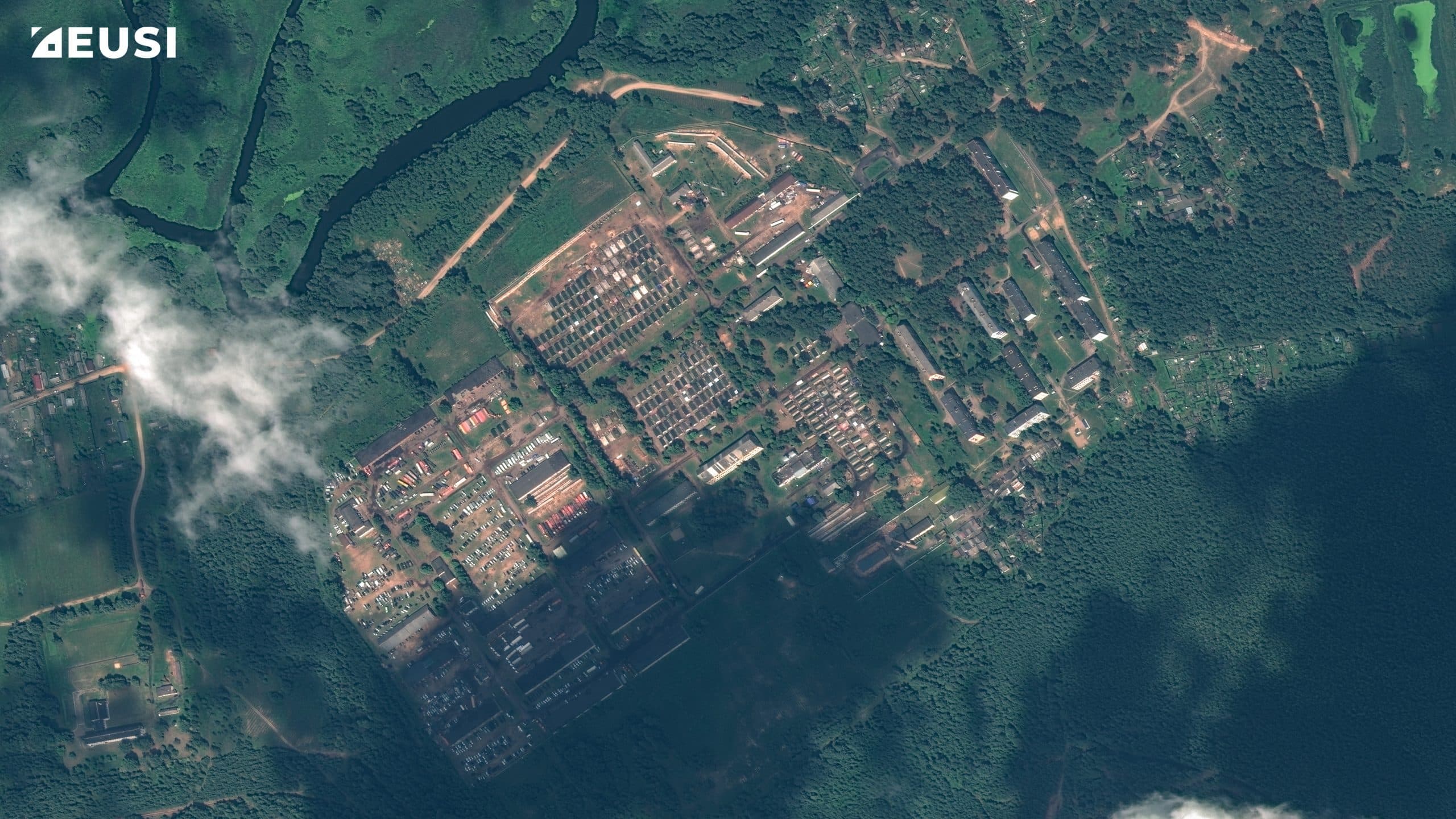
Satellite Imagery shows Wagner Group Base in Belarus

Satellite Imagery shows Wagner Group Base in Belarus
A satellite image appears to show new facilities set up recently, at a military base in Tsel, Mogilev Region, Belarus June 30, 2023. Planet Labs PBC/Handout via REUTERS THIS IMAGE HAS BEEN SUPPLIED BY A THIRD PARTY. NO RESALES. NO ARCHIVES. MANDATORY CREDIT. DO NOT OBSCURE LOGO.

Recently, European Space Imaging (EUSI) has released satellite images of Wagner Group Base in Belarus. The images show increasing activity at the military camp in Tsel, a former military base in Asipovichy District of Mogilev Region in Belarus. A dozen of vehicles, including vans and cars, large civilian trucks, seem to arrive at the new Wagner Camp.

The Tsel camp first appeared in late June 2023, after a supposed agreement between Wagner Group leader, Yevgeny Prigozhin and the Belarusian leader Alexander Lukashenko to end mutiny against Russian forces.

According to reports, Wagner, a Russian private military organization, agreed to relocate its troops to Belarus. The images taken on 19th June show the field of military camp was largely empty. The growth of the base signals shows the private army is relocating large numbers of personnel and equipment under the deal with Belarus.

On 17th July, 31 large vehicles were counted that arrived at Tsel, confirmed by BBC Verify. About 44 miles southeast of Tsel, the BBC has geolocated the footage of M5’s northband carriageway.

The above images clearly shown the increasing development at the location. Credit: Planet Labs PBC
No large vehicles visible near the garages of the military site in this satellite image captured on July 4. Satellite imagery from July 14 confirmed that there was still little activity. Credit: Maxar
More than a dozen vehicles were present at the military camp. Credit: Maxar
Vehicles and what appears to be troops are seen at the field camp. Credit: Maxar
Satellite imagery obtained by the BBC shows that a number of trucks, military vehicles and supplies appeared at the camp on 18 July. Credit: Planet Labs PBC
The image shows a convoy arriving at the camp. Credit: Planet Lab PBC
The images collected by EUSI on 28 July 2023 of the Belarussian military camp. Copyright: Satellite Imagery © Maxar Technologies Collected by European Space Imaging

ALSO READ: In Photos: Satellite Images Capture Wildfire in Greece

The Era of Global Boiling

0
The Era of Global Boiling

July has been declared the hottest month in some say more than 100,000 years. With infernal wildfires ravaging the Mediterranean coastline, from Greek resorts popular with holidaymakers to sylvan Algerian landscape, and Antarctic ice being at its lowest levels, there isn’t any corner of the globe that is unscathed from global warming.

It rarely happens when an expression of foreboding surpasses itself, lending a more imminent sense of urgency and peril. UN chief, Antonio Gueterres’ statement about the dawn of the ‘Era of Global Boiling’ will go down as one such epoch-defining phrase.

By now, it’s become a self-reinforcing truism that global warming is a dire existential menace that needs to be timely tackled if we want to save the planet. Yet somehow, either the message doesn’t resonate hard enough, or there is some sort of complacency or wishful, abstractive thinking, or a gloom-laced fatalism.

Unlike any other juncture in history, we have technology tools and scientific solutions that enable us to monitor, observe, record, model, analyze, and then make optimum plans for better decision-making.

Surfeit of geospatial datasets and the rapidly increasing analytics capabilities due to the power of Machine Learning and AI, puts all the much-needed resources at our disposal.

Thomas Friedman’s ‘World is Flat’ chronicled the early euphoria about 21st-century globalization and the miraculous power of markets hitting its crescendo. Since then, widening disparity, the 2008 financial crash, the pandemic, the Ukraine conflict, and the rise of protectionist tendencies, have dampened the fervor.

However, the ‘flattening’ of the world courtesy Internet, GPS, Digital Maps, and Satellites thrive, even in the face of pushbacks and clamors against trade regimes or political outlooks.

High-resolution satellite imagery, 3D heat maps, change detection patterns, and the vast repository of global Earth Observation Data is the arsenal that we have to muster to mitigate climate change. Customized spatial solutions are being already used in a wide range of applications, from detecting methane emissions to making agriculture more productive.

Countries envision making National Digital Twins and tracking progress on net zero and sustainable smart transition. Certainly, there’s no shortfall where ambitious planning is concerned. But the gulf between vision and action, and the glaring disconnect between ground reality and mega blueprints, needs to be bridged.

This can’t be done without a participative, stakeholder approach that prioritizes grassroots communities, and aims to dispel skepticism and misgivings through concrete visualizations.

Climate messaging that alienates a section of the people cannot work. Preaching to the choir from August pulpits, and the evangelical zeal to institute transition without understanding the interlocking complexities, regional divergences, and the skewed symmetry in power, opportunity, and access, is a recipe for disaster.

Taking a cue from Antonio Gramsci’s famous maxim ‘Optimism of the Will, Pessimism of the Intellect’, Rebecca Solnit writes that the world cannot afford to be climate doomers.

We certainly cannot wallow in the knowledge of an inevitable wracking of Mothership Earth. But seeing that ‘things are hopeless and yet being determined to make them otherwise’, is not something easily attributable to those dwelling on the most vulnerable climate frontiers, where a host of externalities and factors collide.

The multiplicity of approaches, getting rid of reductionist frameworks, and a localized, de-centralized approach through incremental solutions, is the only way to escape this logjam.

ISRO Successfully Deploys Seven Singaporean Satellites into Orbit

0
ISRO Successfully Deploys Seven Singaporean Satellites into Orbit
ISRO’s PSLV rocket lifts off from Satish Dhawan Space Centre, July 29, carrying seven Singaporean satellites. Credit: ISRO/Youtube

India achieved yet another successful space launch on July 29, deploying seven Singaporean satellites into low Earth orbit using its reliable PSLV rocket. This marked India’s sixth orbital launch of the year, all of which were successful.

At 10:01 p.m. Eastern time, the four-stage PSLV rocket took off flawlessly from the Satish Dhawan Space Centre as planned. The launch proceeded according to schedule, with the first stage booster separating about two minutes after liftoff. The payload fairing separation occurred 73 seconds later, followed by the second stage at 77 seconds, and the third stage at 320 seconds.

The upper stage then successfully placed the satellites into their intended orbit at approximately 536 kilometres above the Earth. About 20 minutes after liftoff, the satellites were deployed.

ISRO Director Sreedhara Panicker Somanath congratulated the successful mission, stating, “Congratulations, PSLV-C56 carrying seven satellites, including the primary satellite DS-SAR and 6 co-passenger satellites, have been successfully placed in the right orbit.” He further extended his congratulations to the customers sponsored by the government of Singapore for their involvement in the mission.

Regarding the upper stage, the director mentioned that it would be manoeuvred to a lower orbit of 300 kilometres in the following hours as part of efforts to reduce its lifespan in orbit. While he confirmed another PSLV launch scheduled for early September, specific details were not disclosed.

ISRO conducted the launch under a contract with New Space India Limited (NSIL), a commercial arm of the space agency.

The six co-passengers on this mission included VELOX-AM, a technology demonstration microsatellite; ARCADE, an experimental satellite for atmospheric coupling and dynamics exploration; SCOOB-II, a nanosatellite carrying a technology demonstrator payload; NuLIoN by NuSpace, an advanced nanosatellite facilitating seamless IoT connectivity in urban and remote areas; Galassia-2, a nanosatellite orbiting at low earth orbit; and ORB-12 STRIDER, a satellite developed through international collaboration.

DARPA selects Lockheed Martin to Develop Nuclear-Powered Spacecraft

0
DARPA selects Lockheed Martin to Develop Nuclear-Powered Spacecraft

DARPA selects Lockheed Martin to Develop Nuclear-Powered Spacecraft

Lockheed Martin has won a contract from the Defense Advanced Research Projects Agency (DARPA) to develop and demonstrate a nuclear-powered spacecraft under a project called Demonstration Rocket for Agile Cislunar Operations (DRACO). The project will represent a rapid advancement in propulsion technology to benefit exploration and national defense.

DARPA partnered with NASA’s Space Technology Mission Directorate on the DRACO project, as both agencies will benefit from this technology. The in-space flight demonstration of a nuclear thermal rocket engine vehicle will take place no later than 2027.

Nuclear thermal propulsion (NTP) engines offer thrust as high as conventional chemical propulsion with two-to-five times higher efficiency, which means the spacecraft can travel faster and farther and can significantly reduce propellant needs. They also enable abort scenarios on journeys to Mars that are not possible with chemical propulsion systems.

Kirk Shireman, vice president of Lunar Exploration Campaigns at Lockheed Martin Space said, “This is a prime technology that can be used to transport humans and materials to the Moon. A safe, reusable nuclear tug spacecraft would revolutionize cislunar operations. With more speed, agility and maneuverability, nuclear thermal propulsion also has many national security applications for cislunar space.”

An NTP system uses a nuclear reactor to quickly heat hydrogen propellant to very high temperatures and then funnels that gas through the engine nozzle to create powerful thrust. The fission-based reactor will use a special high-assay low-enriched uranium, or HALEU, to convert the cryogenic hydrogen into an extremely hot pressurized gas. The reactor will not be turned on until the spacecraft has reached a nuclear safe orbit, making the NTP system very safe.

Lockheed Martin has partnered with BWX Technologies to develop the nuclear reactor and produce the HALEU fuel.

While nuclear systems are an emerging field, Lockheed Martin has a long history and expertise in nuclear controls and has built many of NASA’s radioisotope thermoelectric generators for NASA’s planetary missions. Lockheed Martin has also invested heavily in cryogenic hydrogen storage and transfer. This key technology will be needed in deep space exploration not only for NTP, but for conventional propulsion systems.

New Supply Chain Data Partership For A Sustainable Future

New Supply Chain Data Partership For A Sustainable Future
Global logistics network Flat isometric illustration Icons set of air cargo trucking rail transportation maritime shipping

Ordnance Survey (OS), Esri UK, Deloitte, Planet Labs PBC, and Trase, through their collaborative efforts, come together to establish the Supply Chain Data Partnership (SCDP). This ground-breaking initiative aims to provide a location dataset for various global supply chains, fostering resilience against climate change and promoting sustainability.

Tackling Supply Chain Challenges with the SCDP

The SCDP’s primary objective is to instil confidence in the certification and monitoring of assets within supply chains. By offering a reliable location dataset, buyers and investors can ensure transparency and responsible practices. The collected data and certificates will be stored on an international registry that adheres to global standards. The SCDP also targets greenwashing by enabling efficient and trustworthy sustainability reporting, allowing investors to identify both risks and opportunities for green and sustainable investments.

Addressing Sustainability in the Food Industry

The food industry is a major player in global supply chains, with challenges ranging from deforestation to a lack of transparency and traceability. For instance, soy oil, a crucial ingredient in products consumed worldwide, has been linked to extensive deforestation and biodiversity loss. The SCDP aims to assist the industry in transforming its supply chains by engaging with responsible suppliers, reducing emissions, and promoting sustainable practices.

Millions of people consume mayonnaise in the UK every year with Soy Oil being another crucial ingredient that is a worldwide consumable. The cultivation of soybeans has grown tenfold in the last 50 years and the UN’s Food and Agriculture Organisation (FAO) predicts the consumption doubling by 2050. This results in a negative impact on natural habitats and biodiversity.

Palm oil, widely used in cooking and manufacturing, has been a significant driver of deforestation in tropical forests accounting to almost 5% of the total deforestation in the world. The SCDP recognizes the urgency of tackling this issue and seeks to build trust and transparency in palm oil supply chains by verifying the location of assets and encouraging responsible sourcing.

Sustainable Fashion and Textile Industry

The textile and fashion industry’s environmental impact has been a growing concern, contributing significantly to global carbon emissions (10% of the annual emissions).

The SCDP endeavours to support retailers and manufacturers in creating shorter supply chains, responsible sourcing practices, and enhanced transparency throughout the entire supply chain.

To lay the foundation for this ambitious endeavour, the SCDP is conducting a pilot program in Brazil and Iowa, USA, leveraging Earth observation and geospatial data. This testing phase aims to identify and verify various assets within the supply chain with a high degree of confidence, ultimately facilitating effective monitoring by companies and investors.

Testing is being carried out to establish how many assets like mills, and refineries can automatically be identified and verified and whether secondary ground verification is required. This work draws on the expertise of the supply chain transparency initiative Trase. The desired outcome would be to successfully identify the assets with a high degree of confidence and to give a certificate and a unique identifier for effective monitoring by companies and investors.

The Importance of Location Data for Sustainability

Accurate and trusted location data plays a pivotal role in offering transparency and driving change within supply chains. From certification audits to monitoring biodiversity strategies, this data empowers stakeholders to make informed decisions and track environmental impacts.

Elaborating more on it, Donna Lyndsay, Strategic Market Lead at Ordnance Survey said: “We want to demonstrate how location data and technology helps sustainability initiatives succeed by providing accuracy when it comes to monitoring, analysing, and modelling solutions that will help get us one step closer to a sustainable and prosperous future. The current methods of visibility of the supply chain are no longer enough to meet regulatory requirements and customer expectations. Our aim is that the Supply Chain Data Partnership will shine a light on the darker areas of the supply chain and better support due diligence in certification and sustainability claims.”

The SCDP’s vision is to transform global supply chains through collaboration, helping improve economic, social, and environmental conditions. By promoting transparency and monitoring, the partnership aims to reduce environmental risks and build trust in supply chains.

Tara O’Shea, Senior Director of Forests & Land Use, Planet Labs PBC commented: “Earth observation and analytics technologies have a critical role to play in accelerating the global transition to sustainable and resilient supply chains and economies. Planet is proud to partner with the Sustainable Supply Chain Data Partnership, which is leveraging our unique global dataset of satellite imagery and artificial intelligence to build the spatial asset registries regulators, companies, and investors alike need to decouple economic activities from climate and sustainability risks.”

With global supply chains impacting various aspects of the environment and society, the Supply Chain Data Partnership emerges as a beacon of hope for a sustainable future. By providing accurate location data and promoting responsible practices, this collaborative effort holds the promise of building greener and more resilient supply chains.

What are the Top Applications of Remote Sensing?

What are the Top Applications of Remote Sensing?

In geospatial technologies, remote sensing is used to collect information of Earth’s surface by assessing the reflected and radiated energy from a distance. The technology has transformed the way scientists study the planet.

Remote sensing is widely used in various fields including agriculture, land use mapping and monitoring, disaster management, climate monitoring, urban planning, weather forecasting, forest mapping, water management, mining, and so on.

Some of these applications include:

Land Use Mapping and Monitoring

Land use data represents how the landscape is being used for conservation, development, and agriculture. Remote sensing is used to map the land use pattern of large areas and monitor changes that occur over a particular period of time.

Side-by-side panels to show land use change in Charles County, MD from 2014-2018. Source: Dynamic LULC Change, Chesapeake Conservancy taken 25-October-2022

The satellite images provide a clear view of the land and help to determine the area which can be used for what purposes. This information is then used by regional planners and administrators to make policies for regional development.

Agriculture

One of the prime applications of remote sensing can be seen in agriculture. It is used in crop identification, production forecasting, damage and progress assessment, soil mapping and moisture estimation, and agriculture water resource mapping. With satellite images, researchers can identify which area is damaged or where actions need to be taken.

Farming soil observed using remote sensing | Source: https://ars.els-cdn.com/content/image/1-s2.0-S0303243415001142-gr2.jpg

Weather Forecasting

Remote sensing is extensively used to study weather patterns, precipitation, and changes in temperature. It helps to determine the draught and rain patterns in a particular area.

Top: Image showing the location of clouds as measured by geosynchronous satellites. Bottom: Radar image showing the location of rain as measured by Doppler radar stations. (Credit: NOAA, NWS, NSSL)

The extensive amount of data collected through remote sensing allows experts to calculate and estimate future weather patterns. With this information, policymakers can make policies to mitigate the impact of climate change and ensure the sustainability of natural resources.

Urban Planning

Urban planning involves both the development of lands and innovations happening on a site. In urban planning, remote sensing is crucially important for the collection and analysis of data. It is used in exploring regional planning, policies, and strategies.

Pleiades-1A Satellite Image – 2M DEM Urban Area in Dubai (2016); Copyright © AIRBUS Defence & Space. Processed by Satellite Imaging Corporation. All rights reserved.

Experts use remote sensing data to identify urban population growth patterns, analyze overcrowded areas, and make plans for infrastructure development such as public facilities, buildings, and roads.

Forest Mapping

Remote sensing is widely used in supporting forestry management and conservation. With remote sensing technology, the forest area could be easily identified and mapped. It helps to present a clear view of most minute areas where the sun cannot reach, and provide detailed spectral mapping. It is also used to map large forest areas where environmental issues are more severe, such as wildfires.

WorldView-3 SWIR (3.7m) Satellite Image of Wildfires in California’s Klamath National Forest, USA; Copyright © MAXAR. All rights reserved.

ALSO READ: Remote Sensing and Its Evolution

Weekly News Update: July 24 to July 29

0
Weekly News Update: July 24 to July 29

In this week’s bulletin, Overture Maps Foundation launches a global open map dataset. Apple enters Generative AI race with “Ajax”. UN Security Council holds its first meeting on AI risks at UN Headquarters in New York and Rwanda Space Agency signs a MoU with Esri at 2023 Esri User Conference.

Deloitte Study Finds Cities Embracing Digitization, Trust-building, and Talent Development

Deloitte Study Finds Cities Embracing Digitization, Trust-building, and Talent Development

Cities worldwide are undergoing a transformative phase as they recover from the challenges posed by the pandemic and aim to fortify themselves against future uncertainties.

For example, Almaty City in Kazakhstan has taken rapid strides in making itself an attractive destination for students and workers post-pandemic. The city has created a thriving local economy and focused on improving livability parameters, including smart infrastructure, digital services, and building a cosmopolitan atmosphere.

In December 2022, Deloitte and ThoughtLab joined forces to conduct a survey involving 200 city leaders and 2,000 citizens globally. The study sought to gain valuable insights into how cities are proactively building their capacity for change to effectively adapt to forthcoming opportunities and challenges.

The study pinpoints that city leaders must prioritize the development of their capacity for change across various domains in order to realize their vision of becoming the cities of the future.

Addressing the Global and Regional Challenges

Cities are confronted with several pressing global challenges, including climate change, pollution, and public health concerns, encompassing mental health issues. As city leaders grapple with these multifaceted challenges, they recognize the potential strain on social care services in the years ahead.

This is shown in the below figure:

In addition to global issues, cities continue to tackle region-specific challenges. Developing economies contend with traffic congestion and public safety concerns, while developed economies primarily confront housing insecurity.

This is shown in the below figure:

The survey revealed a discernible shift towards rapid digitization and enhanced digital accessibility within cities. This digital transformation is geared towards better service delivery and streamlined governance. Additionally, cities are resolute in their efforts to restore public trust, bolster resilience against climate change, and cultivate a talent ecosystem to thrive in the future.

Bridging the gap by building on key areas of progress

City leaders must also navigate the expectations of their citizens, a task that necessitates bridging the divide between what citizens anticipate from their local governments and what cities can feasibly deliver. Acknowledging such disparities, the surveyed city leaders reported the formulation of plans to bolster their capacity for change. The objective is to adapt to the evolving needs and expectations of constituents effectively.

The survey highlighted several key areas where city leaders have made significant progress in building their capacity for change:

Rebuilding Public Trust: Efforts to enhance transparency, accountability, and inclusivity have been pivotal in restoring public trust in city governance.

Driving Digital Transformation and Innovation: Cities are embracing digital advancements to revolutionize their services and improve the quality of life for their residents.

Building Future-Ready Infrastructure: Investments in resilient and sustainable infrastructure are imperative to prepare for future challenges.

Addressing the Talent Gap: Cities are proactively nurturing a skilled workforce to meet the demands of the future economy.

By actively building the capacity for change, cities can thrive in the face of uncertainty, becoming resilient hubs that lead the way in innovation, sustainability, and citizen well-being.

Necessary Future Steps

According to the Study, City leaders need to deploy a mix of strategies to tackle big challenges and build resiliency for future shocks. Close relationships by building partnerships with different stakeholders will be key to achieving collective outcomes for the city:

Leading with trust: Building public trust is key. City leaders should have a deeper focus on social inclusion and building trust in communities and local networks.

Building cross-border partnerships: Building partnerships with a broader ecosystem should be the focus in the private sector to drive a collective impact.

Strengthening new tech and data governance: City leaders should focus on improving the governance of new emerging technologies, enabling data-sharing, and ensuring data privacy and security.

Driving green transition: City leaders should use artificial intelligence and data analytics to drive decision-making. This can be done by retrofitting older buildings and structures with green technologies to improve energy efficiency.

Zeroing in Sites with Right Insights

0
Zeroing in Sites with Right Insights

With diverse economic and market situations, today’s clients are seeking not only property tenant or transaction information but also comprehensive insights into the surrounding environment and climate-related risks and metrics before zeroing in their site for either business expansion or just starting out afresh.

They are increasingly interested in understanding factors such as sociodemographic data, nearby amenities, transportation networks, and environmental factors like flood zones or wildfire risks.

Besides, in pursuit of their sustainability goals, many companies are prioritizing energy efficiency and addressing climate risks. These areas receive substantial focus as organizations aim to reduce their environmental impact and promote long-term sustainability.

LI’s Role

In light of these contexts, Location Intelligence plays a crucial role in enriching property information and providing insights into market trends and sustainability metrics based on location. By integrating geospatial data, it enables a deeper understanding of properties and their surroundings, empowering professionals to make informed decisions aligned with market trends and sustainability objectives.

Solution

With geospatial technology, JLL delivers real-time applications that provide various geospatial-related information for any given location, to enable property categorization and risk highlighting.

Besides the real time metrics, with a multi-map system, users can seamlessly explore and analyze this information without switching platforms.

In addition to vector data, JLL leverages raster data from remote sensing, such as solar radiation or wind speed information, to enhance their analysis.

Data

These information sources serve a dual purpose: not only for risk metrics and visualization but also for enriching their features to train machine learning models. Additionally, when combined with AR/VR technologies, they can provide a more immersive and interactive experience for users. Language models can be employed to extract relevant information from text data or even generate text automatically, enhancing the overall capabilities of the system. This integration of diverse technologies empowers us to leverage data, enhance user experiences, and leverage the power of language models for more effective analysis and communication.

ALSO READ: Optimizing Navigation in Southeast Asia with Localized Mapping

Namuga Selects Lumotive to Build Next-Gen 3D Sensing Solutions

0
Namuga Selects Lumotive to Build Next-Gen 3D Sensing Solutions

Namuga Selects Lumotive to Build Next-Gen 3D Sensing Solutions

Optical semiconductor pioneer Lumotive announced that it has entered a commercial agreement with camera module specialist Namuga, which will leverage Lumotive’s Light Control Metasurface (LCM™) chipsets to develop solid-state lidar module solutions for a range of 3D sensing applications in the industrial, consumer and automotive markets.

Publicly-traded in South Korea, Namuga specializes in the development and production of cameras and 3D sensing modules. These components are integral to a variety of widespread consumer electronics products such as notebooks, smartphones, and smart home automation. As a crucial supplier for Samsung Electronics’ flagship smartphones, including the Galaxy S23, Namuga also provides diverse capabilities for a range of smart devices such as drones, Head-Mounted Displays (HMDs), and Head-Up Displays (HUDs).

Namuga engaged Lumotive for this supplier agreement to realize the enormous market potential and significant advantages offered by pure solid-state lidar, which is uniquely enabled by Lumotive’s LCM digital beam steering technology. Using the transformative power of metamaterials to steer the laser beam without any moving parts, Lumotive’s LCM overcomes the size, scalability and reliability limitations of traditional mechanical beam steering systems. Namuga’s deep expertise in the miniaturization of sensing modules, combined with the intrinsic advantages of LCM-based beam steering, will enable lidar to expand into new domains of 3D sensing, particularly applications where compactness and weight are crucial.

Through this partnership, Namuga will leverage Lumotive’s LCM products to create a variety of next-generation solid state lidar modules that go beyond robotic automation solutions, extending into additional sectors like services, homecare, and logistics. Lumotive’s technology broadens Namuga’s capabilities in perceiving surrounding information, enhancing performance and opening avenues into future ventures such as autonomous driving vehicles.

Berlin-based Startup to Bridge Climate Finance Gap for Developing Countries

0
Berlin-based Startup to Bridge Climate Finance Gap for Developing Countries

Berlin-based startup KAYA announced its recent launch with an ambitious mission: to break down barriers that developing countries face in scaling up the development of ecosystem conservation projects.

The company aims to mobilize green financial investments, particularly in Africa, one of the world’s most climate-vulnerable regions receiving only 3% of sustainable investment flows.

KAYA’s action-oriented approach intends to help the private sector meet its climate action targets.

In light of the recent Summit for a New Global Financing Pact in Paris, KAYA is already making waves with plans to mobilize financial investments into large-scale nature restoration and conservation projects. Its focus is bridging the accountability and climate justice gap between private sector emitters and developing regions.

“This is a fascinating time for ecosystem conservation and restoration work,” said Chaitanya Sure, Co-Founder & Chief Climate Officer. “The participation of the private sector in environmental markets is tremendously valuable for organizations implementing climate solutions at scale, but the latter is still too small a group to serve the urgent needs of the planet and the growing market demand. That is the void KAYA is set out to fill.”

KAYA is currently conversing with the Governments of Angola and Tanzania about undertaking multi-year reforestation and fire management activities that would restore and protect natural ecosystems in an area of up to 1 million hectares. It aims to finalize an agreement with Angola by year-end.

The company plans to leverage multiple revenue streams including emerging biodiversity credits as well carbon credits. Sure explains, “Delivering positive societal and ecological impacts through carbon markets is often slowed by small carbon assets and high transaction costs, ultimately making it hard for investors to engage. This is what we are trying to solve.”

Working closely with the public sector and local communities, KAYA set out to not only develop but implement these projects through their entire lifecycle, from conception to execution, while managing them on the ground.

One of the few project developers to take this holistic, long-term approach, KAYA’s projects aim to reduce land-based emissions, preserve biodiversity, and create positive social impacts, such as local job creation and infrastructure for life-improving services.

The Berlin-based startup, with a regional presence in Sub-Saharan Africa, takes a science-based approach to aid governments and businesses in mitigating climate change while boosting regional economic growth.

KAYA offers opportunities for companies to meet their climate action targets by restoring nature, thereby contributing to much-needed global carbon reductions.

Mobilicom Expands into New Geographic Markets for Drones & Robotics Solutions

0
Mobilicom Expands into New Geographic Markets for Drones & Robotics Solutions

Mobilicom Expands into New Geographic Markets for Drones & Robotics Solutions

Mobilicom Limited, a provider of cybersecurity and robust solutions for drones and robotics, announced design win sales into three new geographic markets including:

  • A Korean drone manufacturer has ordered Mobilicom’s newly designed and released MCU Maxi Controller PRO, a mobile, handheld Ground Control Station to be integrated and used with its drones.
  • A Brazilian manufacturer of robotics and unmanned ground vehicles ordered Mobilicom’s SkyHopper Datalinks for its small-sized robotics solutions.
  • A Canadian drone services provider in the oil, gas and mining industries also ordered Mobilicom’s SkyHopper Datalinks to distribute real time sensor feed from drones to on the ground users.

These orders bring Mobilicom’s design wins to a total of 48 as of June 30, 2023. Each design represents initial sales of Mobilicom’s systems and components to be integrated into new autonomous systems designed by manufacturers of drones and robotics, many of which are Tier-1 companies. These design wins are expected to lead to commercial-scale orders as manufacturers go to market with their uncrewed and autonomous vehicles.

Leaf Space Completes Capital Increase and Secures Funding for Expansion

0
Leaf Space Completes Capital Increase and Secures Funding for Expansion

Leaf Space, a global provider of ground segment services for satellite operators, announced that it has successfully completed a capital increase for a total of €20 million ($22 million) on top of the availability by the European Investment Bank of a loan for a further €15 million through Venture Debt.

Launched in 2014, the Italian-headquartered company based in Lomazzo (Como) currently supports around 80 satellites and achieved for the first time this March more than 10,000 successful satellite passes during a single month. Since 2020, it has seen a three-fold year-over-year increase in core business revenue and significant growth in capacity demand.

The round was subscribed by lead investors CDP Venture Capital Sgr (through Fondo Evoluzione) and Neva Sgr, alongside SIMEST and Digital Transition Fund – part of the CDP S.p.A. group. SIMEST has also carried out its first operation through the Single Venture Capital Fund, the new direct investment tool dedicated to the internationalization of Italian start-ups and SMEs.

The existing shareholders RedSeed Ventures, Primo Space, and Whysol Investments, all subscribed to the capital increase and contributed to the new funding round, which builds on the success of a previous initiative three years ago. Furthermore, the European Investment Bank (EIB) has committed an additional €15 million in Venture Debt to the Company, and the transaction is in its finalization stage.

“The €20 million of secured funding from new and existing equity investors add up to the €15 million venture debt provided by the European Investment Bank, although to be fully finalized, and underscore the confidence in Leaf Space’s capabilities and the company’s potential for continued growth,” said Jonata Puglia, Leaf Space CEO and co-founder. “It further validates our success and market position as the second largest Ground Segment-as-a-Service (GSaaS) operator in the world”.

“This funding will enable us to further expand our global network of ground stations as well as add several new locations worldwide. We also plan to support new frequencies for remote sensing satellites, continue simplifying the user experience of our services, hire new talent to scale up our activities, and proactively work on new segments of the market and special projects with customers and partners”.

Giovanni Pandolfi Bortoletto, CSO & co-founder, said: “Within the next 10 years, we want to empower a future where spacecraft – regardless of their mission, application, orbit or deep space destination – are seamlessly serviceable and integrated to a plug-and-play (PnP) connectivity service”.

“We are progressing towards efficient, fully automated, and ubiquitous communications with satellites, which will facilitate the ongoing and sustainable expansion of the space ecosystem.

In this context, Leaf Space facilitates such communications with space infrastructures through its automatic scheduler – the proprietary algorithm on which Network Cloud Engine and a distributed antenna network are based and lays the foundation for new ones not possible yet today”.

Leaf Space’s ground segment services are essential for managing satellite communications, data downlink and uplink operations for satellite operators globally. The company’s advanced software solutions, combined with its network of ground stations and expert team, have made it a trusted partner in the satellite industry.

South Korean Startup to revolutionize satellite orbit prediction

0
South Korean Startup to revolutionize satellite orbit prediction

Spacemap, a startup based in South Korea, aims to revolutionize space missions by enhancing safety through its advanced platform technology. The company’s platform can predict satellite orbits and space debris movements, effectively preventing potential collisions, as reported by the Korea Herald.

Kim Deok-soo, CEO and founder of Spacemap explained during an interview with The Korea Herald that their software is designed to address all decision-making challenges related to space safety and efficiency. The primary focus is on predicting and avoiding collisions with space debris to ensure safety. Additionally, they strive to optimize fuel usage during missions to reduce costs and achieve objectives more efficiently.

The European Space Agency has noted a steady increase in the number of space debris objects in orbit. Presently, there are approximately 36,500 space debris objects larger than 10 centimetres in diameter, along with over 1 million objects sized between 1 cm to 10 cm.

The CEO emphasized that as more satellites are launched into low-Earth orbit, around 550 kilometres above the Earth’s surface, the congestion in space will intensify, leading to a higher probability of collisions. For instance, SpaceX currently has around 4,500 satellites in space, and the number of evasive manoeuvres performed by these satellites, as of 2021, averaged around 80 times. This number is expected to have increased significantly since then.

Spacemap’s orbit-predicting platform software is built upon Voronoi diagrams, a tessellation pattern that subdivides a plane based on several points scattered across it. By utilizing Voronoi diagrams, the software can easily determine the number of points surrounding a specific location and calculate the distances between them. This technology forms the foundation of Spacemap’s effective and innovative solution for space mission safety and efficiency.

Site Selection Analysis in Retail

Site Selection Analysis in Retail

The location of a store can determine its success, therefore, rich data analysis and modeling techniques involving demography, environment, accessibility, market spectrum and trade area analysis need to be taken into consideration. Geospatial data analytics helps in making such strategic decisions.

“Location Intelligence enriches property information by providing valuable geospatial context. It integrates sociodemographic data, real estate market trends, environmental risk assessments, surrounding infrastructure, and POI information. This enables professionals to target specific buyer segments, forecast property values, assess environmental risks, and evaluate the desirability of a location,” says Yanqing Zeng, Lead Data Scientist, JLL, France.

On top of the static geospatial data, dynamic mobile data are now being used for retailers to gain a rich, detailed view of the consumers’ profile who visit a particular location, the frequency and timing of their visits, and how long they stay. With this complementary data, retailers can forecast seasonal trends, analyze variations in daily or weekly foot traffic, and observe human migration patterns in the surrounding area. Accordingly, the most ideal site selling the most suitable product lines can be selected based on the catchment characteristics and preferences.

“We see a trend where retailers are looking at a combination of Floating Car Data, to understand Site Selection Analysis traffic patterns in the area around their store, and spending behavior data to understand the business potential,” says Pierre Maere, CTO, Geo Mobility, Belgium.

“Retailers are also looking for innovative ways to attract customers and improve conversions by e.g. being easier found or improving the check-out experience with address validation.”

Here’s how optimal site selection and merchandising help in better retail practices:

Catchment Area Identification

By creating a buffer area on a map, measured in walking/driving time from the nearest residential area, retailers can identify where their target shoppers will come from.

With geospatial data, retailers will be able to visualize how many people lived within a location, distance to potential retail sites, the time of day people were typically near the area and how close the sites are to existing franchises and local competitors. The analytics will enhance predictions as to which potential sites could drive the most volume.

A proposed retail site location also needs to support various amenities such as parking spaces, drive-through window, signage visibility to the main street, and many others. High-resolution satellite data, complemented by geospatial and location analytics can provide the detailed context for retailers.

“When choosing new store locations, we rely on Location Intelligence to analyze population density, traffic patterns, and competitor presence. This data-driven approach helps us identify high-growth potential areas and ensure optimal store placement,” shares Mayank Singh, Chief Digital Officer and VP – Marketing, Digital Business & IT, Domino’s Indonesia.

“Compute time capability is changing the application of technology. It used to be that only a limited amount of locations could be scored with a simple forecasting model. Today we can score thousands of locations at any given time with changing parameters as we select new sites for market prioritization,” says Jan Kestle, President and CEO, Environics Analytics, Canada.

“We used to be confined to the office and a desktop to do spatial analysis. Now, we can run a sales forecasting model to trade area analysis from the field using a phone, tablet or laptop and by entering specific proposed site characteristics that we observe standing at the location of a new store.”

Store Merchandising

By understanding the demographics of the retail area, such as population, age, professions, etc.; commercial indicators such as household incomes and spending patterns; and nearby establishments such as hospitals, restaurants, parks, etc.; retailers can decide which product lines are most profitable for a specific retail site. A goods retailer might use human mobility data, anonymized, aggregated information about how people move based on their mobile network locations, to determine what types of products to stock and store locations to focus on. “In the past, sales data was helpful making these decisions, but it couldn’t reveal anything else, such as how many people walk by your store and their demographic profile,” underscores Bas Jansen Venneboer, Managing Partner, Local Eyes, The Netherlands.

“The other key themes we see in retail are promotions and consumer savviness. More and more we are seeing consumers take advantage of promotions and patiently wait for the right deals. This creates interesting incentives retailers to be extremely strategic about how and when to promote and offer discounts on merchandise,” says Marc Carolus, SVP, Insights & Analytics, Location Products, Mastercard, Germany.

Footfall & In-Store Analytics

Indoor positioning technologies, such as beacons, Wi-Fi, RFID, and geomagnetic, complemented by various cameras, sensors and mobile technologies; have provided retailers with great analytical capabilities.

“Retailers increasingly rely on data analytics and Business Intelligence tools to gain insights into customer behavior, optimize pricing strategies and improve operational efficiency. Advanced analytics techniques, including predictive analytics and real-time data analysis, help retailers make data-driven decisions and identify trends to stay ahead of market demands,” says Morten Brøgger, CEO, MapsPeople, Denmark.

In-store analytics collect and analyze data about customer behavior and interactions within a physical retail space. The analytics capability makes physical stores just as measurable as e-commerce – helping brick-and-mortar stores compete and remain relevant in the digital-first world.

The data collected from such infrastructure can generate insights on foot traffic and movement patterns, popular in-store product areas, the busiest time of the day, and typical dwell times. This information helps retailers optimize store layouts, improve product placements, organize employee schedules, create in-store marketing strategies, and enhance the overall shopping experience.

Carl Barker, VP, Global Omni Programs at Lululemon, a global athletic apparel retailer said “With online RFID solution, we can leverage real-time, accurate data to enable our in-store educators to spend even more time engaging and connecting with our guests. RFID continues to elevate our digital experience, offering accurate real-time store inventory visibility and powering key fulfillment experiences such as BOPIS.”

Footfall Monitoring & Measurement

Infrared/thermal sensors placed at the entrance of a store and geolocation hits from mobile devices are used to monitor and measure footfalls, i.e. the number of visitors entering a store at a particular time. The analytics are done hourly, daily, weekly and monthly, to generate patterns. By understanding footfall patterns, retailers can ensure more employees are working on the sales floor during busy hours, schedule flash sales or other special promotions for specific times. The footfall data can also be used to calculate retailers’ conversion ratio, i.e. how many visitors entering their stores turn into paying customers.

Store Layout & Product Placement

Using a combination of indoor positioning systems, high-precision tracking devices on shopping carts and baskets, and wall-mounted infrared/thermal sensors, retailers will be able to map the full customer journey, from the moment the customer enters a store to the moment they exit.

The system generates heat maps to analyze customers’ behavior and engagement time within the store. Understanding this pattern can help retailers design a better store layout for effective traffic flow, and validate its product placements. New arrivals and high-demand products can be placed in eye-catching and prominent areas where shoppers spend the most time at.

It’s all about automation, integration, and interoperability

Just as diverse ecosystems thrive when interconnected, businesses will flourish when location insights seamlessly merge with other data sources, empowering retailers with a holistic view of their operations.

On top of geospatial and location data, advanced analytics, AI and Cloud native tools will become the backbone of decision-making systems that will help retailers stay agile in the industry.

ALSO READ: Evolving Supply Chain Management in Retail

NextNav Successfully Tests PNT Solution with 5G and LTE Signals

0
NextNav Successfully Tests PNT Solution with 5G and LTE Signals

NextNav Successfully Tests PNT Solution with 5G and LTE Signals

NextNav, a global leader in next-generation GPS, has announced that it has successfully tested its positioning and timing solution that combines the company’s assured PNT (position, navigation and timing) TerraPoiNT system with existing LTE and 5G network signals. The test, which took place in and around San Jose, California, demonstrates how TerraPoiNT signals can be integrated with existing cellular signals to deliver accurate 3D positioning and timing information that is not reliant on conventional satellite-based GPS and GNSS signals.

Using dedicated terrestrial transmitters and LTE/5G signals, NextNav’s system delivers accurate and reliable 3D positioning and timing information and can augment or complement GPS  in places where GPS signals may not be available. This includes indoors, urban areas, or situations where GPS signals may experience interference. Integrating TerraPoiNT with LTE and 5G signals provides a rapid and cost-effective approach to scaling resilient PNT solutions in GPS-denied environments.

“Whether its utilities, banks, data centers, transportation, or emergency services, critical infrastructure today is reliant on GPS for position, navigation and timing services, making it highly vulnerable to GPS as a single point of failure” said Ganesh Pattabiraman, Co-Founder and CEO of NextNav. “With this integration we have demonstrated a highly scalable and lower cost alternative – a 3D PNT solution which overcomes the vulnerabilities of GPS with a complementary ground-based resilient PNT layer that extends PNT capabilities in urban and indoor environments .”

The announcement of the successful Bay Area test follows a recent European Joint Research Centre (JRC) report, which highlighted NextNav’s TerraPoiNT as a mature technology that met or exceeded relevant benchmarks to serve as a resilient layer for existing GPS and GNSS technologies. Previously, in a 2021 report, tests by the US Department of Transportation (DOT) found TerraPoiNT to be the only commercial alternative PNT solution to meet identified needs in “all applicable use case scenarios.”