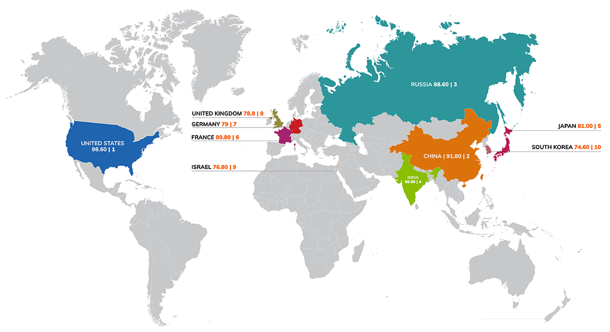
The GKI Tactical Readiness Index (GKI-TRI) offers a comprehensive framework for assessing a nation’s ability to deploy and operationalize geospatial and space capabilities for Defense and strategic autonomy. Unlike broader readiness indices that focus on civilian or commercial use cases, the GKI-TRI evaluates core elements of tactical readiness: sovereign data infrastructure, secured cloud environments, geodetic integrity, real-time GEOINT capabilities, GNSS independence, and rapid reconstitution of satellite assets after disruption. It also considers legal and institutional readiness—especially in navigating data-sharing rules, spectrum management, and international norms. As modern conflict increasingly depends on who controls data, timing, and location across both terrestrial and orbital layers, the GKI-TRI provides a timely and necessary lens for measuring geospatial and space readiness in an era of contested strategic advantage.
The GKI-TRI assesses these capabilities not only through the lens of available infrastructure, but through operational readiness: can these systems function independently, at speed and scale, and under conditions of disruption, whether technical, geopolitical, or environmental? It considers the robustness of cloud infrastructure, resilience of satellite constellations, autonomy of data processing, and integrity of positioning frameworks under real-world tactical conditions. With modern conflicts evolving into multi-domain, data-centric, and electronically contested battlespaces, tactical geospatial readiness becomes a core pillar of national security and a key determinant of strategic advantage.

Collect and process high-frequency satellite imagery to support real-time battlefield awareness and mission planning

Navigate and target accurately in GNSS- denied or spoofed environments, ensuring operational continuity even under electronic warfare conditions

Integrate real-time geospatial intelligence (GEOINT) into command- and-control (C2) systems, enhancing decision-making and force

Maintain geodetic accuracy for precision- guided weapons and long-range strike systems, especially in GPS- contested theatres

Secure continuity of Intelligence, Survell- lance, and Reconnais- sance (ISR) operations in degraded, cyber compro- mised, or space-denied environments

| Indicator Name | Definition | Relevance and Priority | Impact Level |
| Space Sovereignty |
The extent to which a country can design, launch, manage, and control its own satellites and orbital assets without foreign reliance. |
Enables strategic autonomy in spacebased lSR, communications, and PNT functions; critical du ring geopolitical isolation or denied access scenarios. |
Very High |
| Tactical GEOINT Infrastructure |
Availability and integration of EO (Electro-Optical), SAR (Synthetic Aperture Radar), and real-time data fusion systems for defense missions. |
Drives situational awareness, precision targeting, and command-and-control superiority in active combat or contested zones. |
Very High |
| Geodetic Precision Infrastructure |
National geospatial reference systems, GNSS augmentation (e.g., SBAS, RTK), and secure, resilient geodetic networks. |
Supports precision-guided systems, force navigation, and terrain modeling; foundational for reliable and accurate military operations. |
Very High |
| Operational Resilience |
The capability to maintain geospatial operations in GPSdenied, spoofed, or cyberdisrupted environments through redundancy and agility. |
Essential for combat effectiveness under electronic warfare or anti-satellite (ASAT) attacks; underpins mission continuity and survivability. |
High |
| Industrial Innovation & Sovereign Capacity |
The strength of domestic R&D, advanced manufacturing, and supply chains to build and sustain Defense-grade geospatial and space systems. |
Reduces exposure to foreign export controls, tariffs, or supply bottlenecks; enables rapid innovation cycles and technology sovereignty. |
High |