GKI Readiness Index Architecture provides a structured framework to assess a nation's maturity in leveraging geospatial knowledge for digital transformation. It is built around five core pillars—Infrastructure, Policy Landscape, User Adoption, Industry Ecosystem, and Institutional Capacity—each with defined indicators. The index guides policy makers in identifying strategic priorities and closing readiness gaps to enhance geospatial enablement across governance, economy and society.
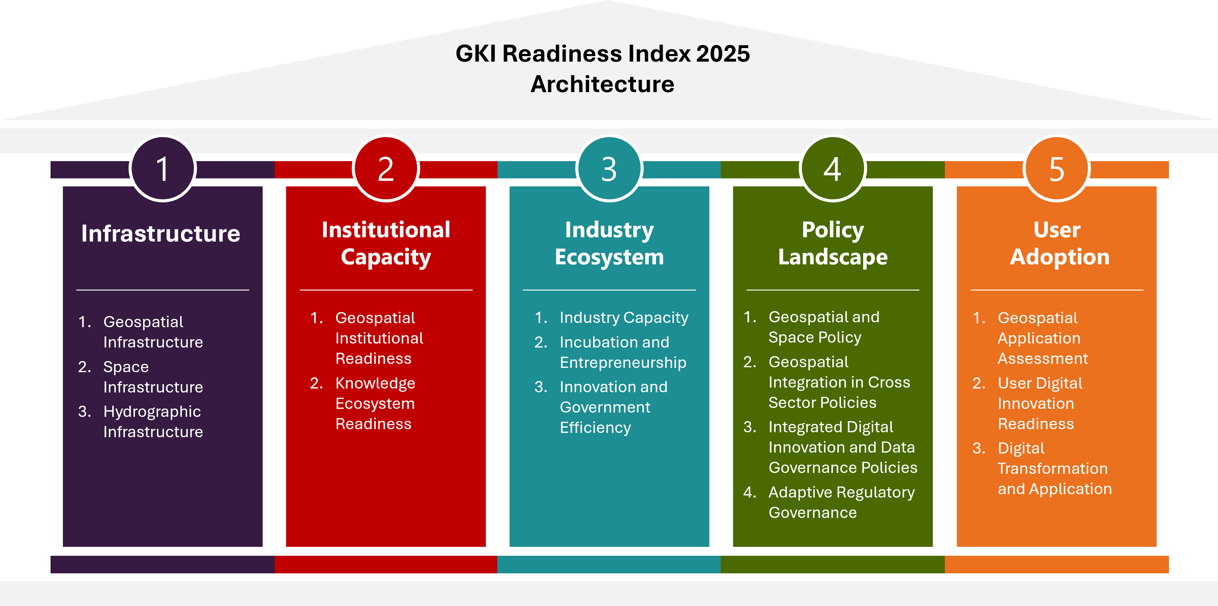
The Infrastructure pillar assesses a nation’s ability to develop, manage, and sustain a reliable and integrated geospatial framework that supports various sectors, including governance, economy, security, and public services. It evaluates the availability, accuracy, and accessibility of spatial data, covering land, marine, and space-based information. This includes technological readiness, data management capabilities, and the use of advanced tools to enhance data accuracy and usability. The pillar also considers the ability to collect and utilize satellite-based and hydrographic data, ensuring reliable navigation, mapping, and decision-making. Additionally, it examines how effectively data systems are maintained, updated, and aligned with international standards, as well as the collaboration between different stakeholders to promote innovation and long-term sustainability.
The Policy Landscape Pillar assesses the extent to which geospatial technologies are embedded within national policies and regulatory frameworks. It evaluates cross-sectoral integration in key domains such as agriculture, transport, urban development, logistics, land management, and energy to determine how geospatial capabilities contribute to national development priorities. Additionally, this pillar examines the coherence and maturity of broader digital policies—including those related to AI, ICT, open data, and digital privacy—that support geospatial innovation. It considers data governance, telecom infrastructure (such as 5G), and AI strategies to ensure a strong policy foundation for geospatial adoption. Furthermore, the pillar measures the presence and effectiveness of specific legal and regulatory frameworks governing geospatial activities, including remote sensing, GNSS, UAVs, and space technologies. It assesses the clarity of institutional mandates, licensing procedures, and compliance mechanisms, ensuring a structured environment that fosters investment, interoperability, and risk mitigation in the geospatial sector.
The User Adoption Pillar assesses the extent to which geospatial technologies are integrated across user sector value chain, public service delivery, and industry sectors, and doing so the role of national geospatial agencies. It evaluates the number, diversity, and maturity of geospatial applications, their impact on operational efficiency, and their role in strategic decision-making. Additionally, it examines how institutionalized geospatial use is across government agencies and levels. This pillar also leverages global indices to measure digital maturity, cybersecurity, and AI readiness in the public sector, using benchmarks such as the E-Government Development Index, AI Readiness Index and others to assess the overall preparedness for adopting geospatial tools within digital governance and public services.
The Industry Ecosystem Pillar evaluates the strength and diversity of the geospatial industry, including technology providers, service firms, and system integrators. It assesses the sophistication and innovation of geospatial solutions, particularly the integration of advanced technologies like AI, machine learning, and big data analytics within commercial solutions, platforms, and service delivery models across the geospatial ecosystem. Additionally, this pillar examines the broader business environment for geospatial firms, considering factors such as investment incentives, firm creation, regulatory clarity, and overall competitiveness. It also analyzes support structures for startups, including incubators, accelerators, innovation hubs, and funding availability, to determine how well the ecosystem fosters entrepreneurship and transforms research into commercially viable geospatial solutions.
The Institutional Capacity Pillar evaluates the readiness and effectiveness of institutions in advancing geospatial research, innovation, and workforce development. It assesses foundational research efforts in geodesy, GNSS, GeoAI, and remote sensing, considering factors such as funding mechanisms, research mandates, staff expertise, and laboratory infrastructure. Additionally, this pillar examines the strength of knowledge creation, diffusion, and innovation linkages by measuring collaboration between universities, research centers, industries, and government agencies. The focus is on how well institutions support geospatial knowledge creation, align research with national priorities, and transfer expertise to address real-world challenges across various sectors.