

Dr Roger F Tomlinson
Tomlinson Associates Ltd.
Email: [email protected]
Geographers have as their task the description and explanation of the living space of humans and of the resulting spatial structure of society. The development of formal views of these concerns forms the basis for the modern science of geography. The extent and complexity of the world we live in makes this task hard. The volumes of data that result from even cursory global investigation are a serious impediment to our understanding. Fifty years ago, it was not possible to handle any large set of the hardcopy maps and data that were being gathered, much less analyse them in any efficient way. The resulting inability, indeed the failure, to ask questions, let alone consider in depth the role of various interacting influences shaping the individual and societal factors left us with a deep and generally unrecognised ignorance of space and time behaviour.
The advent of computers as information processing tools and the development of geographic information systems (GIS) have measurably assisted geographers in their work. The quality of questions asked is rising and the scope and use of spatial analysis is becoming more sophisticated. We are digging deeper into the spatial variables in considering factors that otherwise would not be explored. The trade-off between effort and enquiry is shifting in favour of enquiry. Workers are able to exchange their reasoning (decision models) very easily. This is contributing to the awareness of geography and the growing number of people becoming involved in the field. There is an increasing exchange of ideas and methods. As a result, the study of geography is changing significantly and beneficially, and in particular expanding outside of the academic confines. Geography, as a discipline, is no longer encompassed by academic geography. It is not principally reductionist, curiosity-driven, with a goal to produce general laws (although that is a long established scientific method with great virtue). There is an urgent demand for the use of geographic science in governments, relative to society and to address the pressing issues facing the world. Geographers have major contributions to make to these issues.
There is, for example, broad agreement in the scientific community that the earth’s climate is changing and that it is part human induced. Very little is known, however, about the societal impacts of climate change, and there are very important geographical questions that need to be answered about the changes in bio-geo-chemical cycles, ecosystems, water resources, resource utilisation, continued atmospheric pollution, and the overall economic, political and social implications. Geographers can contribute to the body of knowledge about climate change by synthesising, analysing and modelling possible impacts. Globalisation is about interaction and integration among people, companies and governments of different nations, a process driven by international trade and investment, and aided by information technology. It has effects on the environment, culture, political systems, economic development and prosperity and human physical well-being in societies around the world. Again, the analysis of these conditions has a strong spatial component.
Underpinning social diversity means understanding and generalising the processes of spatial heterogeneity: that of defining characteristics of patterns and processes on the surface of the earth. Understanding these processes, which account for social diversity, difference and inequality, is key to good governance.
The following are illustrations of some of the ways in which GIS is being used to examine spatial situations.
Climate
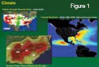 Figure 1 shows the magnitude of occurrence per unit area of all East Pacific and North Atlantic Basin tropical cyclones. Data extends back to 1851 in the North Atlantic and to 1949 in the East Pacific. The Palmer Drought Severity Index is the basis for agricultural relief for farmers in major distress in the USA. Of particular interest is the analysis of drought on nuclear power plants. They require large volumes of water for cooling purposes and sustained drought means that they have to be closed down, removing their supply of electricity in the states concerned.
 Human impact
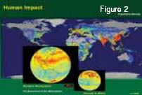
Figure 2 shows the human impact map due to the global population density, inset with two hemispheres showing the CO2 emissions in the atmosphere using real time Jet Propulsion Laboratory satellite sensor information.
Human footprint
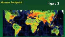 The human footprint aims to measure the extent of human interference on the earth’s surface, using updated data on human population density, land transformation, human access, electrical power infrastructure and settlements (Figure 3) (Slide3). This latest version was produced in 2008. The work was produced by the Humanitarian Information Unit of the Office of the Geographer and Global Issues ( Director Dr Lee Schwartz) of the Bureau of Intelligence and Research in the United States Department of State.
 Avian flu
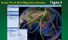
Avian flu and bird migration routes illustrate the correlation between known outbreaks of avian flu and bird migration corridors to assist in the process of identifying the source and the diffusion of the disease (Figure 4). The same GIS application allows users to identify quarantine stations, flu shot clinics and local public health departments.
AIDS
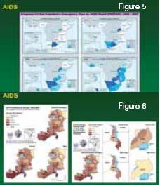 Figures 5 and 6 show the progress on the President’s emergency plan for AIDS relief (PEPFAR) in sub- Saharan Africa as a basis for policy change. Also included are results in Vietnam and Guyana. Further analysis and understanding of the AIDS epidemic in Africa, particularly Kenya, Uganda, Tanzania and Zambia and Malawi are examined by gender showing the percent HIV positive in four categories (2-5%, 5-10%, 10- 15% and more than 15% of the population). Similarly, the HIV prevalence among youth by first order administrative divisions in the countries concerned, again as a percent of the general population and by gender. These studies underpin the effective delivery of AIDS relief in sub-Saharan Africa and the monitoring and analysis of programme effectiveness.
Afghanistan opium cultivation
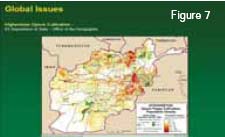 Now supplying 80% of the world’s heroin, this is a global issue. Map in Figure 7 compares the population density in Afghanistan with the areas of poppy cultivation. The Taliban are operating extensively in the southern area of the country and have recently started operations in the northeast.
Plant hardiness zone migration
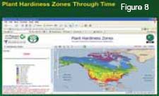 The Nature Conservancy at the University of Washington has calculated the plant hardiness zones in 1960 and 2008 and 2099. The movement north of the boreal forest and the ameliorating temperatures in the Arctic islands are particularly noticeable. Implications for habitat can be measured and better appreciated.
Commercial applications
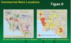 Commercial store locations give the illustration of increasing use of geography in the business community, analysing how specific retail outlets are located with respect to the drive distance in mile from their nearest competitors and the subsequent analysis of areas with access to more than one store to ensure that new store locations do not compete in the trade area of existing stores (Figure 9).
It is not surprising that GIS and geographical analysis are being widely used. But the diffusion of geographical analysis methodology throughout the real world is quite remarkable. Based on GIS licensing records, there are few countries or government departments in the world that area not using GIS. At least five million people in over 300,000 institutions in over 155 countries are doing geography using geographical methods in their work daily.
The largest campuses investigating geographical analysis are not in academia but are in the private sector. Using the assumption that every $1 million of investment of data and GIS systems requires at least one trained person to for the investment to be used effectively, then there is a shortfall of at least 3,000 trained people per year in North America alone, compared to the output from all universities and technical colleges in North America. Students are realising that geography offers career opportunities and interesting jobs throughout the working world.
Interest in the discipline is growing. Academic geography may be splintering into quasi-named departments and sub-specialties, but students who are trained in geographical analysis and can use the modern tools of GIS are in high demand.
The growth of this interest is exemplified in the growth of the Association of American Geographers which has increased by 50% in the past decade alone. Similarly indicative is the reintroduction of Geography at Harvard after an absence of 60 years in the new Center for Geographical Analysis.The extensive development of quantitative geography in the 1960s and 1970s addressing the problems of analysing and modelling space need to be integrated with the GIS capabilities of today and brought together to develop wider and more generally applicable models of geographic space and time focussing on interactions and dynamics.
We still have no adequate models for major cities, much less for the world itself. There are many research questions that remain to be investigated on the way to creating Al Gore’s ‘digital earth’. There are questions that touch on many aspects of geography, including representation, efficiency of information management, appropriate scientific visualisation of issues, applications, and policy implications. GIS will be at the core of this progress and the future will be rich and productive.


