
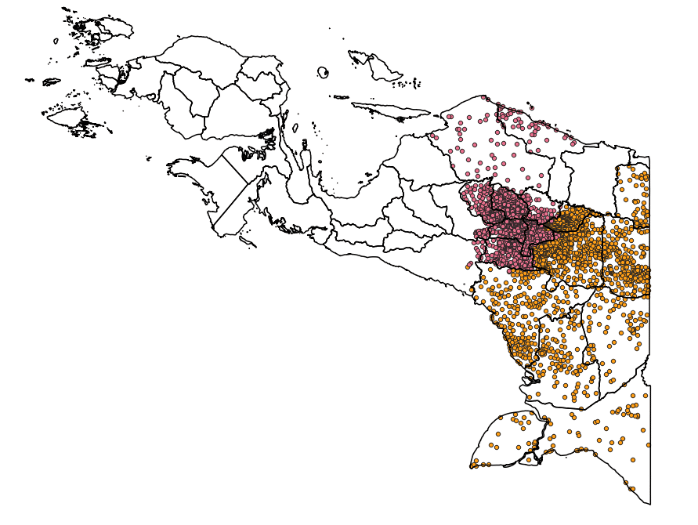
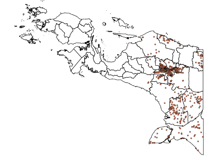
By using AI with PlanetScope satellite imagery data, EOfactory.ai suggested an entire network of telecommunications infrastructure for province scale within two months.
The COVID-19 pandemic has demonstrated the critical importance of telecommunications infrastructure in keeping economies and societies connected and running. The telecommunications services industry consists of digital infrastructure (fiber, telecommunications towers, active networks, and data centers), operators (mobile and fixed broadband, data centers, and cloud computing), and applications (broadband connections, telephony, video, e-commerce, and others). Because of the disruption caused by the pandemic, the world has been relying on technology for information, social distancing, working from home, and many more things.
The telecommunications sector has seen tremendous technological advances in the last few decades. However, despite progress in access to mobile and Internet services, many people and businesses remain disconnected. Globally, 3.7 billion people, which is almost half of the world’s population, remain unconnected.
The rural divide
A large portion of this unconnected population lives in rural areas. As per the GSMA report, rural people are still 37% less likely than urban populations to use mobile Internet. One of the most significant issues for mobile network operators (MNOs) is extending connectivity in rural areas, where the initial investment and daily operating costs are higher than in urban areas.
Indonesia, which is the world’s fourth-largest island country, is also facing the challenge of the digital divide. In 2020, 43.36% of the population in Indonesia were residing in rural areas. Today, around 3.5 billion Indonesians lack Internet access, impacting their ability to work or find new work opportunities, participate in educational activities or connect with near ones. It’s also limiting them from getting timely information regarding their health and safety from organizations like the World Health Organization.
Mobile towers located in remote areas of the country require frequent site visits to see the updated conditions. Due to inaccessible conditions and lack of basic infrastructure, it sometimes takes three months to conduct the survey manually. The MNOs need real-time and frequent updates that are not possible in the case of the manual survey.
The project
In March 2021, a province-scale project in Indonesia was initiated by an EOfactory.ai’s client who provides telecommunications infrastructure in remote areas. Under this project, spatial analysis on the satellite imagery was done. The satellite data supplied by PlanetScope constellation (operated by Planet) gave the location of communication towers in the province. EOfactory.ai, an Artificial Intelligence (AI) and Machine Learning (ML) platform, analyzed the availability of village populations and their access to roads.
AI solution for telecom
The use of modern technologies like AI can help in overcoming the challenges faced by telecom infrastructure providers. AI can automate traditional land surveying practices, allowing MNOs to detect, extract and analyze multiple development-ready villages within a couple of months. AI-enabled automatic extraction helps get faster results of the object or features in remote areas such as roads, built-up areas, and water extraction.
The EOfactory.ai platform can extract objects or features within a short time using automatic extraction. It can also integrate with the latest PlanetScope imagery data. For this province-scale project, EOfactory.ai first analyzed the satellite data using an AI model and extracted crucial information of built-up area and access (road). After this, the spatial analysis was conducted to get the information on the availability of the built-up regions and access inside the buffer that the client defined.
Procedure followed

The workflow (Figure 1) utilizes the U-Net AI model to detect roads and urbanization. EOfactory.ai tweaked and engineered this model—the larger the training set, the more precise the urbanization detection model would be. Therefore, it is possible for both small and large infrastructure enterprises to achieve maximum accuracy within a short timeframe.
At first, EOfactory.ai created the training dataset that included training images and labels. The number of training samples used at the learning stage has a significant impact on the performance of any classifier—as they learn the characteristics of the data from the sample values and do not use ensemble derivatives, such as the mean, standard deviation, or variance/covariance matrix. The use of fewer training samples in neural networks means that characteristics of the classes cannot be derived, while the use of a large number of training samples requires more time for learning. The accuracy was most influenced by the training set size, with higher accuracy obtained using large training sets.
The second step was splitting the training dataset into two groups, i.e., training and validation. The training set is used to train the model, and the validation set keeps validating the model. Before the training processing, the dataset needs to be pre-processed, for example, eliminating the noises or no data. If the model is validated and not suitable, then the training process readjusts the hyper-parameters until the model reaches the right standard. After that, the model is exported to do the next step, which is prediction.

After prediction, post-processing is applied—this step is crucial because usually, the results will lose information on the edge. This drawback can be overcome for a large area by overlapping each other when cropping images to put on the network model. The classification output is a matrix whose size is equal to the size of the input image. The value of the elements in the matrix in the range [0, 1] represents the probability of belonging to the line class of the network, corresponding pixels on the image.
Pixels with values greater than 0.5 are considered to be the border and are labeled 1. The other pixel will have label 0. After that, quality control is applied to check if the results are precise or not. Then the results are converted to shapefile using the Rasterio library; regions are represented as polygons, the polygons are then simplified by algorithms such as RDP (Ramer-Douglas-Peucker).
Result and analysis
EOfactory.ai then does the analysis by running the detection using the pre-existing model.
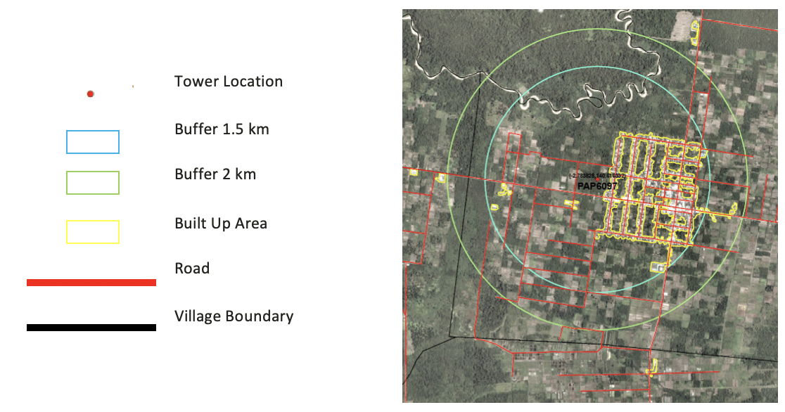
After considering road quality and level of urbanization, along with spatial analysis with a particular buffer from the tower point, the EOfactory’s AI model suggested that the tower point in this location was an ideal location to expand telecommunications infrastructure. This also ensured commercial sustainability as good roads allow network upgrades. An urbanized area entails an opportunity to enhance demand for mobile services, therefore unlocking revenue opportunities that can improve the profitability and attractiveness of investments.
With PlanetScope satellite imagery data, EOfactory.ai suggested an entire network of telecommunications infrastructure for province scale within two months. The telecom infrastructure company (EOfactory.ai’s client) only had to calibrate the scale of their operations according to their timeline and budget.
Advantages of EOfactory
EOfactory.ai built the architecture to support and run their AI/ML algorithms and processing at the data source to avoid unnecessary transfer of huge data volumes. The platform also protected the movement of data within the network. AI extraction and spatial analysis reduced the cost of transportation and increased time efficiency. EOfactory.ai’s telecommunications client got on-time and real-time information that helped them in faster decision-making leading to closing the project on time.
Satisfied customer
“The goal of this project was to use remote sensing as part of communication development and infrastructure in the remote area. Planet’s satellite imagery coverage in a very cloudy area was difficult, but with EOfactory.ai’s solution, we got the accessibility to a remote location, which helped us make decisions faster. This solution made it possible for us to survey the land of more than 1000 square km in less than two months, including generating map and imagery output.”
Dr. Robert, Head of IBS Tower for Telecom Project, Indonesia


