
 Along the border between extreme northern Maine and western New Brunswick, Canada, two surveyors, one Canadian and one American, faced numerous problems while surveying the region – fewer control monuments, many lying beneath a cover of snow much of the year; limited cell-phone coverage; rugged terrain and UHF transmission limitations. In such a situation, they found Ashtech Pro- Mark™ 500 RTK solution to be a better way to survey in the region’s challenging conditions. Michael Cyr, owner of Northern Maine Surveyors in Madawaska, Maine, works across the St. John River border from Gaetan Soucy, proprietor of Arpentages Gaetan Soucy. Both are essentially in the same business: property boundary, topographic and construction surveys for residential and commercial development. Because each understands the value of staying at the technological forefront of his business, each benefits from a rover and static base system with communications and algorithms that integrate GPS, GLONASS and SBAS signals to complete surveys faster and more easily, providing savings to their clients.
Trying out an Ashtech demo
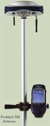
In 2009, Cyr, whose business is based about 50 miles from the nearest CORS station, had a chance to demo an Ashtech ProMark 500 dual-frequency GPS / GLONASS GNSS system, with an embedded U-Link UHF radio, from The Sidwell Company.
“There is a learning curve for any new hardware/software system,” Cyr says, “but operating this new system was easy.” However, he adds, “it does require an understanding of various coordinate systems, scale factors, grid, true and magnetic reference systems as well as the ability to localise.” Just as any surveyor would not stake out a corner without a good zero reference and distance check on his backsite, I quickly learned that localisation is the most critical step in performing a stakeout or adding information to an existing system.”
Fast and easy localisation
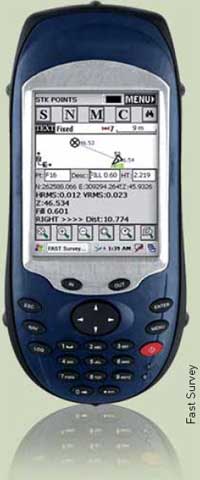
 The Ashtech FAST Survey field software that is loaded on the ProMark 500 makes file manipulation with localisation easy and certain. With the base and rover at two existing control points, FAST survey can rotate, translate or scale to the ground system. “A check on a third control quickly verifies that you are ‘in’ your coordinate system and you can now navigate to set any point number in your file,” Cyr said. “With 16 satellites, radio link and Bluetooth icons glowing and ‘fixed’ sign indicated, one can simply walk the rod to zero,” he says “Always confirm that the RMS and radio latency are good. For a quick check, press the ‘Reset RTK’ on screen and within 20 seconds or so, the display shows ‘Float,’ then ‘Fixed’ to verify your position again.”
Operating close to the border has its limitations for radio use. “However, the embedded U-Link radio, with settings up to 4 watts, achieves an impressive range and is adequate for most situations.”
The MobileMapper™ CX field terminal with Fast Survey™ is easy to use, Cyr says. “Going into unknown and difficult terrain, I just pack the rover antenna (without any wires) into my backpack, select any point number loaded in Fast Survey and navigate with the MobileMapper to within a few meters of the next corner. Setup the rover, establish RTK communication and set your corner when ‘Fixed.’
Cyr describes a familiar situation: “Your client’s conversation with the neighbour involves a four-acre addition to the rear of what you have just staked out. Fast Survey can extend, intersect, coordinate and calculate area on-site, then stake out in RTK. The rover will guide you to set points along a line as you navigate to your next corner as well. The ability of the ProMark 500 Base to log raw data in a static session while I’m out roving in RTK is a onebutton operation.”
OPUS post-processes and provides Cyr with a high accuracy National Spatial Reference System coordinate to use as a reference. This is a fully automated free system and requires minimal user input. ProMark 500 rover can also log raw data and Cyr has, with a 15-minute observation, obtained centimeter post-processed accuracy in the most extreme conditions of the North Maine woods.
RTK, Canadian-style
Across the border in Edmundston, New Brunswick, Gaetan Soucy has been surveying using GPS techniques for more than eight years. His GPS work involved setting his static on a known coordinate monument and using the controllers to set a small network that was then postprocessed. About a year ago, he too came to know of the benefits of RTK surveying.
With the availability of an Active Control Station in almost every Canadian city and a growing number of private control stations from which he can buy information, real time corrections are always available. “While our system of control monuments here has deteriorated and become less and less available, our newer network of active control stations has taken their place,” Soucy says. Now with his Ashtech ProMark 500 GNSS base station and rover RTK system, purchased from Gemini Positioning Systems Ltd. in Ottawa, Soucy no longer has to look for or find control monuments in the ground. “With the active control information, my base station location doesn’t have to be known,” he says, “I just set the base anywhere, preferably a high point and begin logging raw data. I can use my rover immediately and simultaneously.”
“Logging raw data at the base station while simultaneously surveying with my rover is a time saver,” says Soucy. He says that in his experience, when he is within 10 km of the control station, he only needs to log an hour of raw data and at 40 km he likes to log several hours.
In reviewing his RTK options, he found that base and rover systems that required cellphone communication with the rover did not meet his needs, since cell-phone coverage in the areas he works is generally unavailable. He requires UHF communication. The UHF radio at 2 watts that’s embedded in his system meets his need.


