
Vaibhav Arora
Assistant Editor, Geospatial World
[email protected]
 Land is an essential resource upon which the very existence of our society depends. Therefore, it becomes imperative to optimise this valuable asset for better economic development and social stability, especially considering the fact that unlike most other resources, land cannot grow in size. All these aspects make it necessary for governments across the globe to develop effective land administration systems. In African countries, especially, the tremendous importance of land is not only reflected in its economic value but also its spiritual significance. Land is the key for overall growth and development of the African economy with most countries relying heavily on agriculture for a significant share of their gross domestic product.
Signifying the importance of land for African people, Aida Opoku-Mensah, Director-ICT & S&T Division (ISTD), UN Economic Commission for Africa says, “Land is very critical for the African people. It was the basis of our struggle for independence and continues to be the key for our future transformation and development. Today, land reform is very high on the political agenda in Africa. The transformation and reform of the land sector will have immense economic opportunities for us.”
According to experts, Africa’s reliance on land will continue in the near future and thus the need for improved land policies becomes even more significant.
CADASTRAL SYSTEM IN AFRICA
The existing cadastral systems in a majority of African nations had been introduced by colonial powers, which were primarily looking to satisfy their own interests without paying much attention to the customary land tenure laws. Although there have been several attempts to transform the prevalent cadastral systems into traditional practices, most of these have been unsuccessful because of various issues such as lack of skilled manpower, insufficient funds, scarcity of technical know-how and lack of political will.
In the past few years, land tenure systems have generated a renewed interest amongst experts, owing to the advancements taking place in the field and new technologies that have revolutionised cadastral systems. The table on the next page gives an overview of the prevailing land tenure systems in some of the African nations:
| Existing Cadastral Sytems in Africa
Ethiopia Kenya Zambia Malawi Mauritius South Africa Nigeria Botswana TLIMS (Tribal Land Information Management System) aims to enable the Land Boards to process applications and be able to manage tribal land electronically. The system was also intended to facilitate data sharing between various land boards and other government departments. CIS (Cadastral Information System) was developed to secure and make the internal cadastral workflow inside the Department of Surveys and Mapping more efficient by using modern technology with suitable applications. LAPCAS (Land Administration, Procedures and Capacity Building System) is a joint venture between Botswana government and the Swedish International Development Agency. The purpose of the project is to improve land administration and to build capacity in the management of this scarce resource. |
 Uganda
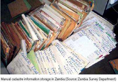
MODERNISATION EFFORTS
Cadastral systems in most of the African countries have been inherited from the colonial regime and require drastic changes to suit current requirements. While the process of land reform has been going on in Africa since the past few years, a lot of shakeups are still required to ensure flawless systems. Some of the modernisation efforts in the field of cadastres in Africa include:
South Africa has implemented the Integrated Spatial Information System (ISIS), which aims to create a webbased system for seamless dissemination of information. The primary objectives of ISIS is to assimilate the existing property systems into a unified cadastre that consists of both spatial and non-spatial data. The system also seeks to equip the service providers with the latest land data in order to improve service. In addition, the country is also using remote sensing technology for land reform process.
The Government of Uganda has recently employed the STDM (Social Tenure Domain Model) project that focuses on developing tools capable of registering a wide range of land rights including public, private and customary rights. The project is an important step towards poverty alleviation by providing land rights for people living in informal settlements. The country has also undertaken the Systematic Surveys project in which all land parcels within a particular area are surveyed and subsequently registered. The system reduces costs and stems off bureaucracy.
Various regions in Ethiopia have prepared their own land laws and have also set up institutions to promote effective land administration. The Ethiopian Mapping Agency has the role of modernisation of cadastres through various means such as establishment of ground control points to help in the survey process, preparing base maps and contributing to the process of capacity building. The Sustainable Land Management project intends to address the issue of land degradation in the country and improve the yield of smallholder farmers.
In Kenya, the process of computerisation of land records has already started with emphasis on training the staff, acquiring new-age survey devices and purchasing computer hardware and software. A local area network, which will be connected to the office of commissioner of lands, has been established. Other initiatives include the creation of a national parcel numbering system. The Kenya Agricultural Productivity and Sustainable Land Management project aims to encourage the farmers to adopt environment friendly practices. The country is also working on implementing the national spatial data infrastructure that will create a repository of information and thus help various agencies in making informed decisions.
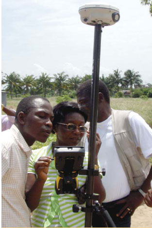
In 2002, Malawi implemented the National Land Policy, which aimed at ensuring security of tenure and promoting overall development through optimum use of land. The policy intended to register all land managed by traditional authorities, decentralise title registration to avoid delays and promote gender neutral land access. With the help of modern techniques like GPS, Electronic Distance Measurement and Total Stations, it has become possible to collect data in the field and download it into the computer, which facilitates planning.
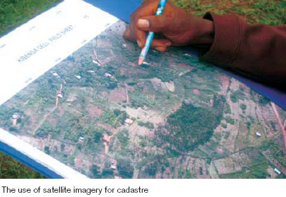
Traditional cadastral system in Rwanda entailed marking of the boundaries using objects like trees, stones etc. Rwanda plans to implement the International Terrestrial Reference Frame in the near future and is currently establishing an extensive network of permanent reference stations. Modernisation efforts in the country include the implementation of terrestrial based techniques such as GPS, theodolite and total stations and spatial techniques such as aerial photography and satellite imagery for creating a cadastral database. In 2002, the city of Kigali implemented a cadastral database for the purpose of tax collection. Efforts are on to develop a multipurpose national database that would help in land use monitoring, tax collection, mortgage, registration etc.
Tanzania is working on a project called the Sustainable Management of Land Environment, which intends to help in land management and the production of cadastral maps. The process of digitising analogue data is currently underway. The country has signed a Memorandum of Understanding with the Government of Finland under which the Finnish government will keep it updated with latest technology to promote effective land management.
CHALLENGES AND WAY AHEAD
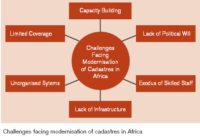
Land tenure systems in Africa are faced with umpteen challenges that need to be resolved in order to ensure better and efficient land use. Some of the primary challenges that require urgent attention include:
Capacity Building: Capacity building includes both human resource development and the procurement of equipment that can support modernisation. Capacity building can address various issues by filling gaps in terms of office and logistics of land-related institutions. Besides, it can also help in the establishment of uniform cadastral systems in urban as well as rural areas. Highlighting the importance of using new technologies, Hussein Farah, Director General, Regional Centre for Mapping of Resources for Development says, “We need to modernise the way we do mapping, surveying and introduce the use of devices like GPS to collect data and the use of satellite imagery.” The severe lack of skilled manpower is hampering the growth of several countries. “There are very few people who are trained professionals in land management. We have to pick up people from the elementary level and train them.” says Mohammed J. Omar, Acting Director, Department of Surveys and Mapping, Zanzibar.
Digitisation of Records: Land records should be digitised and have to be easily accessible through the internet for decision makers. New ways of standardising land tenure systems will also have to be evolved. There is need for computers that can store every type of information found on paper and can also help in searching and analysing land parcels and their attributes. “Digitising the cadastral database will improve the administration of land and make information easier to access. Land transactions will become less expensive and quicker.” says Hussein Farah.
Enhanced Coverage: A prominent feature of the current state of cadastres in Africa is that very small areas in most countries have the required ownership information. A lot of work needs to be done to address this issue. “Coverage is an issue that needs to be addressed. Only small parts of the countries have cadastral maps and ownership registration,” says Hussein Farah.
Better Organised Systems: Unstructured cadastral systems give rise to numerous problems. Besides, there is inadequate availability of maps at appropriate scales and over-reliance on old topographic maps. Underlining the ill-effects of having numerous systems in his country, M.N. Kajumbula, Commissioner Surveys & Mapping- Uganda says, “Having four land tenure systems is cumbersome as each of these is a difficult system, so there is need for research on these systems to come up with a new system which can address all issues.”
Other issues include large amount of analogue data, inadequate sharing of geo-information, lack of infrastructure and exodus of skilled staff to the private sector.
Although governments in Africa realise the importance of land reforms and have implemented a number of legislations to develop land tenure systems, not all of these have produced the desired results. Innovative approaches are underway but the need of the hour is to change the mindset of the people to implement drastic changes that can effectively work to modernise the redundant, decade old systems currently in existence.


