Home 2024 January

Monthly Archives: January 2024

Geospatial to Outpace Market Predictions Across Value Chain

Geospatial to Outpace Market Predictions Across Value Chain

Tech integration, data sharing, and localization to be major drivers of growth

The widespread utility of geospatial data and insights across sectors is increasing at an exponential pace, redefining sectors, and unveiling newer streams of investment.

According to estimates, the Indian geospatial sector would be worth INR 63,000 Crores by 2030. However, Anup Jindal, CEO, RMSI earnestly believes that it has the potential to exceed this figure, clocking a higher growth.

“There’s a direct co-relation between the growth trajectory of geospatial and India’s overall growth, and it will continue”, he adds.

At the Frontier

As India looks forward to becoming a robust and dynamic innovation hub, geospatial would be a key driver of economic transformation.

Cloud, AI, and ML would be other game-changers powering growth. Be it razor-sharp customized analytics, or building immersive solutions, there is a growing integration of frontier tech with geospatial.

“With AI and ML, the value chain of geospatial is moving up. For planning and visualization, things are moving towards 3D Models and eventually to Digital Twins”, says Sreeramam GV, CEO, NeoGeoInfo Technologies.

Data Access

While there is plethora of data available from different sources, go-to sources and right inventories are either missing or hard to access. Unrestricted data access, standardization, and interoperability are crucial for developing cutting-edge applications and solutions that exceed customer expectations.

 “Data access and availability has been one of the challenges. Another is turning data into solutions to solve problems. There is a need for more data-sharing and collaboration”, states Rajesh C Mathur, Advisor, Esri India.

“A lot of data-fusion and amalgamation from a problem-solving perspective is expected. Triad of cost, turnaround time, and coverage is where space data is unbeatable”, believes Prateep Basu, CEO, SatSure.

“Traditionally, EO has been a much smaller part of geospatial, however with more sensor varities the dynamic is changing”, he adds.

Need to Localize

The impetus towards local capacity building is at the core of the government’s push towards indigenous R&D, critical for turning India into an innovation powerhouse.

“Trimble is actively involved in localization. We can ‘Make in India’ for the world as well. Just like IT evolved from services to solutions, geospatial needs to follow the same trajectory, but within the next five years”, says Rajan Aiyer, Managing Director, Trimble India.

“Cross-collaboration and scalability are also crucial. While India is known for software, there is a need to focus more on hardware as well, so that the brand value of the ‘Made in India’ mark increases”, he adds.

Synspective Signs MOUs for Disaster Solutions in Uzbekistan & Kazakhstan

0
Synspective Signs MOUs for Disaster Solutions in Uzbekistan & Kazakhstan

Synspective announced that it is entering into memoranda of understanding (MOUs) with Uzbekistan’s Center for Space Monitoring and Geoinformation Technologies and Kazakhstan Gharysh Sapary (KGS), the national space agency of Kazakhstan.

In early January, along with key ministry officials from Uzbekistan, Kazakhstan and Japan, attended the MOU ceremonies held in both countries.

Monitoring for potential identification of seismic risks in Uzbekistan

This collaboration in Uzbekistan is designed to carry out research and development for risk evaluation using interferometric Synthetic Aperture Radar (InSAR) technology.

Previous large-scale earthquakes and landslides in Uzbekistan and nearby areas have highlighted the pressing need for predicting and managing land disasters.

SAR, an advanced technology capable of yielding high-resolution imagery of the Earth’s surface, is crucial for monitoring land displacement.

This could aid in the potential identification of seismic risks in Uzbekistan, thereby aiding in disaster preparedness and mitigation.

Interferometric Synthetic Aperture Radar (InSAR) is a technique for mapping ground deformation using radar images of the Earth’s surface that are collected from orbiting satellites.

Seeking Innovative Applications of Earth Remote Sensing in Kazakhstan

Synspective and KGS in Kazakhstan will initially focus on developing new applications for Earth remote sensing and radar data, especially in disaster management, including the mitigation of landslides, mudflows, floods, and effective infrastructure management to reduce the impacts of climate change.

Additionally, this collaboration opens avenues for joint international commercial projects, enabling Synspective to capitalize on its satellite data and analytics solutions.

Concurrently, it offers KGS the opportunity to enhance its technological capabilities and explore further potentials of this emerging technology.

Motoyuki Arai, Founder and CEO, Synspective, commented on these partnerships saying, “Partnering with Uzbekistan’s Center for Space Monitoring and Geoinformation Technologies and the KGS in Kazakhstan marks another step forward in our mission to make SAR data accessible and beneficial across various global industries for challenging social issues with partners.”

“We will contribute to building resilient infrastructure and promote the efficient and secure use of natural resources and energy in Central Asia and Japan, while consistently improving our technologies to support these initiatives. Furthermore, by expanding our network and exchanging experiences, we are moving forward to achieve a sustainable future with our partners,” he added.

Mr Aliyev Soibjon, Director, Center for Space Monitoring and Geoinformation Technologies, Uzbekistan, says, “The mutually beneficial strategic partnership established in recent years between the two countries serves as a favorable basis for the further expansion of bilateral cooperation in many sectors, including in the field of space technology.”

Mr. Aidyn Aimbetov, Chairman, JSC, National Company Kazakhstan Gharysh Sapary, commented, “The accumulated experience of Kazakhstan’s specialists in radar technologies will allow us to begin new projects with the Japanese company Synspective. Joint cooperation and the use of Japanese advanced technologies and the potential of Kazakhstan can be the main solution for the successful implementation of these projects.”

Need of Unified Geospatial Interface akin to UPI

Need of Unified Geospatial Interface akin to UPI

Geospatial Artha Summit 2024 begins in Goa with the theme ‘Simplifying complexities, Amplifying Impact’.

While technology interventions and targeted solutions remove redundancies and frictions, creating new opportunities for businesses as well as consumers, what often gets overlooked is the enabling mechanism via conducive policy regulations.

Policy Synergy

Through a forward-looking, pragmatic policy, milestones can be achieved. This is one of the reasons why in the past few years we have seen remarkable strides in conducive policies that aim to nurture holistic ecosystems.

“The Space policy aims that India should get a significant pie of the space economy. Ever since the launch of the world’s first satellite in 1957, we got a new way of thinking. However, space economy doesn’t only mean space assets and infra but spatial information, insights, and data”, says AS Kiran Kumar, Member, Space Commission, and Former ISRO Chairman

He emphasizes on the synergy between geospatial policy and space policy.  There is a tremendous potential for India.

Digital Public Goods

“India leads the way in the world in digital payments, more than the top five countries put together. This has been possible due to UPI( Unified Public Interface), a digital public good, which has changed behavior and removed inefficiencies”, Srikant Shastri, Chairperson, Geospatial Data Promotion and Development Committee (GDPDC). 

“We need to create geospatial as a digital public good. Multiple sectors from agriculture to logistics stand to benefit from a unified geospatial interface”, he adds.

Cloud is to Digital Revolution, what Manufacturing was to Industrial Revolution: Clint Crosier, AWS

Cloud is to Digital Revolution, what Manufacturing was to Industrial Revolution: Clint Crosier, AWS
What Manufacturing Was to Industrial Revolution, Cloud is to Digital Revolution: Clint Crossier, AWS

In an exclusive interview, Maj. Gen (Retd.) Clint Crosier, Director of Aerospace & Satellite, Amazon Web Services (AWS) shares insights on the ongoing shift towards cloud, the era of AI & ML, on-board processing, in-orbit computing, sustainability initiatives on Earth as well space, and more.

“What mechanized manufacturing proved to be for the industrial revolution, Cloud will be to the digital revolution. Companies, organizations, and governments that don’t take advantage of the advanced technology available with the Cloud won’t stay competitive or relevant over time”.

Krishi Decision Support System Will Transform Indian Agro: Chief Soil Survey Officer

Krishi Decision Support System Will Transform Indian Agro: Chief Soil Survey Officer
Geospatial based Decision Support System will be Game Changer for Indian Agro: Chief Soil Survey Officer

In an interview with Geospatial World, Milind Wadodkar, Chief Soil Survey Officer, Soil & Land Use Survey of India, speaks about the role of geospatial data and technology that is equipping farmers with knowledge about their crops, farmland, and soil, and how they can take the benefits of government schemes.

He speaks in detail about the different schemes and portals that are being developed under the Ministry of Agriculture to help the Indian farmers know about their farm land and suitability of crops that can be grown there.

60 Years of Indo-French Space Ties

60 Years of Indo-French Space Ties

Indo-French space partnership has been evolving since the inception of the Indian space program back in the 1960s.

Recently, the two countries initiated a bilateral strategic dialogue on space issues and developed a thermal infrared satellite project.

“Building on a great tradition of over 60 years of technical and scientific space collaboration and to address the contemporary challenges in space, India and France have agreed on setting up a bilateral dialogue on space issues,” says the joint statement, which cements this partnership.

Joint Synergies

The partnership began in the early 1960s when India’s first sounding rocket launch carried a French payload. India’s Department of Atomic Energy (DAE) soon signed a MoU with the French space agency Centre National D’Etudes Spatiales (CNES) for training ISRO scientists.

A crucial project came in the 1970s when ISRO and CNES worked together on developing the Viking engine. This engine was utilized in the liquid-fuelled stages of ISRO’s Polar Satellite Launch Vehicle (PSLV), Geosynchronous Satellite Launch Vehicle (GSLV), and the Geosynchronous Satellite Launch Vehicle Mark III (GSLV Mk III).

“I always reflect upon the two countries’ joint development of two satellites, Megha Tropiques and SARAL, as a key example of synergies,” says Sanjay Nekkanti, Founder, Dhruva Space.

Launched in 2011, the Megha-Tropiques satellite studied the life cycle of convective systems that influence tropical weather and climate and their role in the associated energy and moisture budget of the atmosphere in tropical regions.

Two payloads; the Sounder for Probing Vertical Profiles of Humidity (SAPHIR) and Scanner for Radiation Budget Payloads (ScaRaB) were supplied by CNES, while another Microwave Analysis and Detection of Rain and Atmospheric Structures (MADRAS) were jointly developed with ISRO for developing SARAL (Satellite with ARGOS and ALTIKA) which was launched in 2013.

SARAL, the satellite with ARGOS and ALTIKA was launched in 2013 to study oceanography. The satellite later proved to be useful for various fields such as marine and meteorology and sea state forecasting, climate monitoring, biodiversity protection, seasonal forecasting, and improving maritime security.

“The bilateral relationship is one built on trust and assurance of each Nation’s technological and developmental capabilities, and it is encouraging to see this has not changed,” adds Nekkanti.

The recent burgeoning of private space companies around the world has also cultivated a collaborative nature of inter-nations. Dhruva Space shook hands with French SatCom Company Kinéis for a joint technological and commercial space project to enhance Kinéis’ global IoT connectivity.

“Cooperation between CNES and ISRO is among the most longstanding and successful there is, not only for France and India, but in the entire history of astronautics,” says CNES Chairman & CEO Philippe Baptiste.

Unique Opportunities

India and France have their own set of fortes and challenges. One is capable of successfully launching satellites into space at a relatively lower cost while the other has a stronghold in research and development and manufacturing processes.

“France is a major space player in Europe with the only launch system (Ariane 6) available in Europe; India is building its medium and heavy-lift rockets by 2030. Collaboration towards building launch systems, and satellite manufacturing is a great way forward between France and India,” states Dr. Namrata Goswami, an author, professor and consultant specializing in space policy, international relations.

“Both the countries have committed to working on space norms and guidelines through United Nations Committee on the Peaceful Uses of Outer Space (UNCOPUOS). This is a vital step as both India and France are major space players in their regional context.

“Collaboration between India and France on norms regarding responsible use of space, space capabilities like satellite manufacturing and launch systems, and building resilient supply chain mechanisms, will empower both France and India to establish their status as major powers in space. Collaborating on missions to the Moon and Mars is another venue for space cooperation,” she adds.

“A combination and exchange of capabilities is definitely possible between both the nations. Now that India is aiming to launch a human spaceflight mission in the coming years, countries like France might emerge as the potential partners or collaborators,” believes Omkar Nikam, Space and Defence expert.

ISRO’s Gaganyaan mission, a human-flight rocket bound for space in 2025 – has been hailed as an ambitious plan by no small means around the world. The mission is to launch three astronauts into space to carry out space research and exploration activities and demonstrate India’s capability to launch and safely return the crew to the Earth.

To aid the mission, CNES signed an agreement in 2021 under which equipment developed by the space agency, tested and still operating aboard the International Space Station (ISS) will be made available to Indian crews for training purposes.

Moreover, the CNES will also be supplying fireproof carry bags made in France to shield equipment from shocks and radiation.

“Both the countries recognize the pivotal role that space applications play in economic and social development. From natural resource management to disaster prediction and rural connectivity, their joint space projects have real-world impacts, improving the lives of their citizens and contributing to national development,” states Eric Fajole, Trade Commissioner – Embassy of France in India.

Structural Limitations?

Working under the ambit of the European Space Agency (ESA), CNES still has to prioritize the European market and capacity building over venturing into the outer world.

“CNES will not be as open as maybe the US in terms of selling,” avers Awais Ahmed, Founder & CEO, Pixxel.

“But of course I think there’s possibilities for working together with French companies to expand into the European market, through European space agency programs and so on,” he adds.

However, with regular agreements and MoUs signed between the nations, the critiques might not be far-fetched. Two years ago, ISRO launched the Oceansat-3 satellite – dedicated to studying oceanography and atmospheric studies – the payload named ARGOS was provided by France.

For one, the governmental agreements might dry up, but the recent uprising of private space companies in India may bag the chance. “We’re seeing joint ventures coming, space players and the French space players. So there was traditional cooperation between CNES. Now we are looking at it spreading from industry to industry,” says Lt. Gen (Retd) AK Bhatt, Director General, ISpA (Indian Space Association).

Note: Nibedita Mohanta, Assistant Editor, contributed to this article

Weekly News Update: 22 to 27 January

0
Weekly News Update: 22 to 27 January

In this week’s bulletin, Google Pay India Signs Agreement with NPCI for UPI Global Expansion, Need to Focus on Earth, Not on Moon: Portuguese Space Agency, Saab signs GlobalEye support contract with UAE, Greg Scott Joins PVBLIC Foundation as Executive Director, SDG Data Alliance, Genesys to Acquire Radarr Technologies, Intermap Technologies wins a $20 million contract to map Indonesian Island, French Location Intelligence Company Acquires Spanish Geospatial Intelligence Platform.

Capella Space, Floodbase Partner for High-Resolution SAR Data

0
Capella Space, Floodbase Partner for High-Resolution SAR Data

Capella Space announced a partnership with Floodbase to bring high-resolution SAR satellite data to Floodbase’s end-to-end solution for parametric flood insurance.

This partnership will enable enhanced payout trigger certification of parametric insurance products by capturing the magnitude of flooding at high resolution and regardless of cloud cover.

Flood risk is growing due to climate change and other factors. Traditional insurance alone cannot fill the gap, making parametric flood insurance a crucial tool for augmenting flood resilience.

Floodbase leverages a variety of datasets to meet the growing needs of the parametric flood market, now enhancing their solution with best-in-class SAR imagery from Capella’s satellite constellation.

Floodbase’s multi-sensor fusion approach allows the company to seamlessly add additional sensors for payout trigger certification to optimize policy design for clients. Leveraging Capella’s automated tasking API, Floodbase can quickly task SAR imagery when need at night or through cloudy conditions to validate flood maps and verify the magnitude of floods at specific locations.

This will strengthen Floodbase’s ability to produce reliable, large-area flood maps, regardless of weather or time of day.

As a certified Capella Analytics Partner, Floodbase will have access to a range of exclusive program benefits that can be leveraged to further expand analytical capabilities, increase customer value and accelerate product development.

These benefits include open access to Capella’s imagery archive for research and development, and both product and sales collaboration.

“We are thrilled to partner with Floodbase to leverage the value of Capella’s all-weather SAR imagery and automated tasking system to help close the flood insurance gap,” said Dan Getman, VP of Product at Capella Space.

“The combination of Floodbase’s large-area parametric insurance solution with Capella’s high-resolution SAR imagery will unlock new parametric use cases to support at-risk communities of severe flooding events.”

“Floodbase has a high bar for accuracy and reliability when evaluating new sensors. We were incredibly impressed with the resolution and reliability of Capella’s SAR sensor, and especially excited about the ability to automate tasking via API,” said Annbjørg Medhaug, Chief Product & Strategy Officer at Floodbase.

“A Parametric flood insurance solution built on Floodbase and Capella data will be superior than competing solutions for a broad range of use cases and clients, and I’m excited to scale the combined solution.”

Closing the insurance gap requires partnerships, collaborations, and a portfolio of solutions. Floodbase and Capella Space share a commitment to using earth observation science and machine learning to enable all communities to prepare for and respond to climate disasters.

Saab Signs GlobalEye Support Contract with UAE

0
Saab Signs GlobalEye Support Contract with UAE

Saab and the United Arab Emirates (UAE) Ministry of Defence have signed a contract and Saab has received an order regarding in-service support for the GlobalEye Airborne Early Warning and Control (AEW&C) solution.

The order value is approximately USD 190 million with a three-year contract period that runs until 2026. The contract includes maintenance and logistics support, as well as training services.

“This agreement solidifies Saab’s role in ensuring that GlobalEye remains mission-ready. We look forward to further strengthening our partnership with the UAE Air Force and Air Defence and providing long-term local support,” says Carl-Johan Bergholm, head of Saab’s business area Surveillance.

GlobalEye is an advanced multi-domain AEW&C solution with an array of active and passive sensors that provide long-range detection and identification of objects in the air, at sea and over land.

By providing real-time information to units in air forces, armies, and navies, GlobalEye enables enhanced situational awareness of the surrounding areas and early detection of threats.

HERE Technologies Expands Partnership With What3words

0
HERE Technologies Expands Partnership With What3words

HERE Technologies, the world’s leading location data and technology platform, today announced an expansion of its global partnership with innovative addressing system what3words. Starting this year, customers using the HERE platform’s Location Services application programming interfaces (APIs) will be able to easily activate their what3words license via HERE.

HERE is making what3words available in its platform amid increasing consumer demand for the innovative location technology. HERE’s automotive customers are already able to activate their what3words license via their HERE account managers, and the latest agreement between the two companies will bring this offering to customers across other verticals.

HERE and what3words first partnered in 2020 to offer automotive customers the next generation of precision in-car navigation. Since this announcement, the joint solution has already enabled major players including Jaguar Land Rover to enable the technology with ease.

Customers of HERE include nearly every global automaker, leaders in e-commerce, transportation and logistics, and public sector agencies worldwide. By adding what3words functionality to its platform, HERE is making it as quick and easy as possible for these clients to introduce the tech to their own systems. This has proven to be increasingly important to customers as consumer demand for what3words continues to grow across the globe.

Clare Jones, Chief Commercial Officer at what3words commented “Our partnership with HERE has proven to be a major accelerant to our growth in the automotive industry. Integrations that would have taken years of development can now be done in months, and innovative updates can even be delivered over-the-air. The speed and ease offered by this partnership will enable what3words to leapfrog slow legacy processes that have held back innovation in other industries, and we’re incredibly excited by the opportunities this partnership presents.”

Remco Timmer, Vice President of Product & Technology at HERE Technologies commented “As the world’s leading location platform, we’re committed to providing our customers with best-in-class products and services. what3words’ innovative technology creates another layer of precision in the way the world communicates location and we see so much potential in making what3words readily available for thousands of our customers around the world.”

French Location Firm Acquires Spain-based Geospatial Intelligence Platform

French Location Firm Acquires Spain-based Geospatial Intelligence Platform

Mytraffic, a location intelligence and traffic analytics company has acquired Geoblink, a geospatial intelligence platform for an undisclosed amount. They aim to become the go-to partner for European businesses and public entities seeking state-of-the-art location intelligence solutions. This acquisition integrates Geoblink’s geospatial technology with Mytraffic’s analytics platform.

With offices in Berlin, Paris, London, Madrid, and Milan, Mytraffic’s SaaS platform enables companies make better decisions through dynamic and tangible traffic data insights. Its major markets are France, Belgium, Italy, Spain, Germany, UK, Finland, Norway, Denmark and Sweden.

Backed by Nauta Capital and Elaia Partners, Geoblink has become a trusted partner for companies seeking to optimize strategies based on geospatial data.

Mytraffic recently closed a €30M Series B funding in September 2022 with AXA Venture Partners (AVP).

“This first acquisition will enable us to become an undisputed leader in the UK and Europe, while maintaining our capacity to be in the forefront of innovation in this sector”, said Hakim Saadaoui CEO, Mytraffic.

Expanding European Footprint

Launched in 2017, France-based Mytraffic is on its way to become one of Europe’s biggest location intelligence firm. Identifying the major issues in retail sector, Mytraffic found its place of providing location insights to real estate investors and retailers.

With more than 300 international clients, including global brands such as JLL, Cushman & Wakefield, H&M, and Hugo Boss, Geoblink’s 150 clients would now be added to its kitty. Geoblink’s major clients include Danone, KFC, Pepsico, and IKEA.

Mytraffic believes that retailers will be driven by location insights to boost performance, and tomorrow’s commercial assets will be valued on the basis of a location’s foot traffic.

“We see a trend where retailers are looking at a combination of Floating Car Data, to understand Site Selection Analysis traffic patterns in the area around their store, and spending behavior data to understand the business potential,” says Pierre Maere, CTO, Geo Mobility, Belgium.

Location Intel for Retail Sector

Location technology empowers brick and mortar store owners as well as e-commerce retailers to get a complete understanding of the consumer journey, connecting both online and offline touchpoints for optimization and budget allocations.

Closed loop attribution enables marketers to gain a holistic, full-funnel understanding of the impact of their media, based on all the key performance indicators (KPIs) that matter to them, irrespective of whether they are related to in-store conversion.

“Retailers increasingly rely on data analytics and Business Intelligence tools to gain insights into customer behavior, optimize pricing strategies and improve operational efficiency. Advanced analytics techniques, including predictive analytics and real-time data analysis, help retailers make data-driven decisions and identify trends to stay ahead of market demands,” believes Morten Brøgger, CEO, MapsPeople, Denmark.

In 2022, Unacast, a global location data and analytics platform partnered with Precisely, a global leader in data integrity software, to offer comprehensive, business-enhancing solutions for multinational retailers looking to expand to a new site. They offer insight into foot traffic and migration patterns, and can map customer profiles and data to optimize success in a new location.

Last year, CARTO, the cloud-native location intelligence platform joined forces with Doorda, the data provider of UK properties to provide geospatial data analytics capabilities.

“Location Intelligence enriches property information by providing valuable geospatial context. It integrates sociodemographic data, real estate market trends, environmental risk assessments, surrounding infrastructure, and POI information. This enables professionals to target specific buyer segments, forecast property values, assess environmental risks, and evaluate the desirability of a location,” said Yanqing Zeng, Lead Data Scientist, JLL, France.

Intermap Wins Major Indonesian Mapping Contract

0
Intermap Wins Major Indonesian Mapping Contract

Intermap Technologies, a 3D geospatial products and intelligence solutions company, announced it has won a $20 million contract to map the Island of Sulawesi, Indonesia in 2024.

The Contract is the first phase of the Indonesian national topographic base map program to create a national digital base map as part of the One Map program backed by the Presidential Decree.

Under the One Map program’s approved technical specifications, the government will collect airborne IFSAR-derived elevation data and cloud-free radar imagery for the entire country at resolutions suitable for 1:5,000 scale mapping.

The first phase awarded today represents 10% of the country’s land area and 10% of the One Map program. Work on the remaining 90% is expected over the subsequent four years.

Indonesia’s national geospatial agency, Badan Informasi Geospatial (BIG), has been mandated to create a national digital base map. Indonesia is the fourth most populous country and one of the largest and fastest-growing economies in Southeast Asia, strategically positioned on the major trade route through the South China Sea.

Basemaps play a critical role in policy formation, decision-making and implementation of activities such as natural resource management, disaster response and spatial planning.

Creating basemaps to the 1:5,000 scale specification requires high-resolution remote sensing data, including imagery and digital elevation models (DEMs), to extract details like buildings, roads, land cover and terrain features.

Indonesia is home to the world’s largest tropical peatlands and mangrove forests as well as the third largest tropical rainforest. These natural resources are vital in capturing carbon, helping mitigate climate change impacts, and are key resources for supporting Indonesia’s long-term development. Basemaps are essential for developing spatial plans, emergency response and natural disaster rehabilitation.

The Contract procurement to achieve this objective included a competitive process, which evaluated multiple commercial airborne and satellite technologies and sensors.

Today’s award represents one of the largest single-source topographic mapping programs ever and demonstrates that national mapping agencies value Intermap’s unique airborne, native-3D Interferometric Synthetic Aperture Radar (IFSAR) collection, high-quality elevation data and rapid processing technology.

Intermap and its partners will utilize Intermap’s IFSAR to map the entire Island of Sulawesi, an area of more than 180,000 square kilometres. No other company can meet Indonesia’s technical requirements within the budget and timeframe allotted by the Contract.

Intermap has an exclusive partnership with the subsidiary of a state-owned enterprise, PT Pratama Persada Airborne (PPA), which leverages the strengths of both parties.

The partnership combines Intermap’s cutting-edge, patented IFSAR collection technology and data processing expertise with PPA’s extensive local knowledge, resources and government support.

Together, the companies provide an unparalleled mapping solution for this first phase of the Indonesian national mapping program and future work under the One Map program.

Today’s Contract is expected to be the first phase of the One Map program to map approximately 17,000 islands, spanning Indonesia’s entire territory, covering equatorial Southeast Asia. The follow-on contract is expected to take four years and will complete the foundation base map, with additional agreements to support the maintenance of the base map.

“This major contract in Indonesia highlights the value of our decades of experience, commercialization expertise and technological development,” said Patrick A. Blott, Intermap Chairman and CEO. “We have had a presence in Indonesia since the 1990s and have received numerous contracts over the past two decades.

The progression of our technology, our exploitation of relevant data to drive valuable commercial use cases and the expansion of our operations in Indonesia is a testament to our ability to respond to challenging client requirements — in this case, in-country processing, stringent data specifications and ability to work closely with the local surveying, mapping, government and business communities.”

Indonesia is located in the cloud belt, often blanketed with persistent cloud cover, and mostly composed of rural areas and dense tropical rainforests. IFSAR technology is the only mapping solution that offers cloud-penetrating and foliage-penetrating capabilities at the resolutions required to achieve 1:5,000 scale mapping.

Intermap’s IFSAR is approved by the Indonesian government as a preferred technology, capable of achieving the required basemap standards. This award demonstrates the high degree of confidence Indonesia has in the collection and processing capabilities of Intermap and its partners. Indonesia plans to commercialize the data and Intermap is uniquely positioned to contribute its extensive experience and capabilities to create exploitation tools for applications such as flood mapping, navigation, resource management and infrastructure monitoring.

Under the terms of the Contract, which is subject to additional amended terms and conditions regarding subcontractors for the final allocation of taxes for goods and services, Intermap will provide collection, processing and delivery of high-quality elevation data and imagery data as part of a consortium of other local operators.

Shared Opportunities for Collaboration in a ‘System of Systems’ Realm

Shared Opportunities for Collaboration in a ‘System of Systems’ Realm

In this exclusive conversation between Andrew Anagnost, President & CEO of Autodesk, and Jack Dangermond, Founder & CEO of Esri. Moderated by Sanjay Kumar, CEO of Geospatial World, they talked about how Esri and Autodesk are teaming up, focusing on the integration of GIS technology with engineering tools. The discussion emphasizes how people in the geospatial and engineering fields work together, pointing out the historical practice of sharing information and the current trend of collaborating on technical projects.

Genesys to Acquire Radarr Technologies

0
Genesys to Acquire Radarr Technologies

Genesys, a global cloud company in AI-powered experience orchestration, announced it has agreed to acquire Radarr Technologies, an AI-based social and digital listening, analytics, and consumer engagement company. 

By combining the comprehensive public social media capabilities within the Radarr Technologies solution with the all-in-one Genesys Cloud platform, Genesys will empower organizations to unify the customer experience (CX) like never before, helping them create proactive, prescriptive engagement built to drive loyalty in the AI economy. 

People around the world, especially digital natives, are using public social media channels to connect with businesses as an alternative to traditional service channels. Using public social feeds or direct messaging, they expect brands to turn these inquiries for service, support and information into meaningful experiences.

With Radarr Technologies capabilities, Genesys will help organizations meet customers on the social channels of their choice so they can engage with them as naturally as they do with family and friends through rich social media-based experiences that are easy, contextual and personalized. 

Following the acquisition, which is expected to close in the first quarter of fiscal year 2025, Genesys will use Radarr Technologies’ social media insights as a critical source for its 360-degree customer view fueling Genesys AI. Genesys will be able to further connect attitudinal, sentiment and interaction data from across the CX continuum and provide the industry’s most comprehensive depth of consumer engagement touchpoints.

Organizations using Radarr Technologies capabilities on Genesys Cloud will be freed from the silos and limitations that prevent them from delivering personalized experiences wherever their customers are by harnessing new insights and capabilities to create loyalty and gain a competitive edge. 

“As consumers increasingly turn to social media platforms to connect with brands for support, these channels become a crucial and largely untapped opportunity for organizations to engage with customers and glean valuable business insights,” said Tony Bates, Genesys CEO and chairman. “Once the capabilities of Radarr Technologies are integrated into Genesys Cloud, Genesys can accelerate its transformation of the CX industry by helping organizations further connect every touchpoint into the end-to-end customer experience.”  

Through the integration of Radarr Technologies, Genesys Cloud customers will gain direct access to new conversation streams from public social media posts across multiple platforms, including Apple App Store, Facebook, Instagram, X, YouTube, Google Play, Google My Business and more. When combined with the Genesys Cloud platform’s voice and digital offerings, including its leading private social media messaging solutions, organizations will have unmatched capabilities to listen to their customers on these channels and turn these inquiries into loyalty-building conversations.  

​Using the response engine capabilities of Radarr Technologies with Genesys Cloud, the combined solutions will empower agents by giving them holistic customer journey context and tools that enable them to connect with customers on their preferred social channels, whether responding to inquiries on public feeds or direct messaging.

Additionally, the differentiated AI-powered Multilingual Sentiment Models within the Radarr Technologies solution will further strengthen the natural language processing (NLP) of the Genesys Cloud platform. This will expand organizations’ ability to detect regional slang and colloquialisms across more than 100 languages, including the top 10 spoken worldwide and more than 40 Asian languages and dialects. This allows organizations to better understand customer sentiment for enhanced ability to deliver personalized experiences at scale.  

“Organizations have struggled to tap into the potential that social media can play in delivering differentiated customer experiences — Genesys is now in a better position to change that,” said Sheila McGee-Smith, president, McGee-Smith Analytics.

“Connecting these public feeds with the orchestration of the customer journey will provide companies not only a more holistic understanding of consumer behaviour and sentiment but the tools to take action through more enhanced personalization and engagement. In adding Radarr Technologies capabilities to Genesys Cloud, the company recognizes the rising importance global enterprises are placing on social interaction management and analytics to achieve a complete unification of the customer experience.” 

French Space Startup Aldoria Receives EUR 10 Million Funding

0
French Space Startup Aldoria Receives EUR 10 Million Funding

French space tech startup Aldoria, one of the leaders in the domain of Space Situational Awareness has received Series A Funding of EUR 10 Million from a syndicate of investors.

Formerly known as Share My Space, Aldoria has managed to receive investment of EUR 22 Million in total till date.

“We have been striving for half a decade to make Earth orbits recognized as part of our environment. More and more people in the space community and beyond have become aware of the space debris issue. We are very happy that orbital environment protection is now supported by green finance, and we are therefore particularly proud of our partnership with Starquest Capital through their Protect Article 9 fund, with the continued support of our existing shareholder Expansion Ventures, as well as several public investors,’’ says Romain Lucken, CEO, Aldoria.

The statement adds that the number of active satellites in low Earth orbit is expected to grow from nearly 9,000 today to 40,000 in 2030. The ramifications of this increase are already noticeable. Aldoria’s orbital information system has generated 230,000 independent measurements on 5,000 objects and anticipated 30 million close approaches between resident space objects in 2023. Amid the growing insecurity caused by the lack of space traffic rules, Aldoria is taking control back by advising operators on real-time threats.

The company says that it stands at the forefront of global innovation with its cutting-edge optical system, renowned for its wide field of view capable of detecting large amounts of small objects including stealth satellites. The precision and clarity offered by its patented optical systems provide a competitive edge in capturing detailed information about the space environment. With over 20 customers and a unique network of six optical surveillance stations on four continents, Aldoria is now ready for its next development stage, it says.

Besides expanding the network to 12 stations by 2025, one of the strategic objectives is to develop and refine a multi-sensor approach to address more customer use cases through data fusion. Overall, Aldoria is set to offer a competitive European SSA solution to the global market. The Series A funding will facilitate the expansion of its presence, investments in local talents, and contributions to the growth of the European space ecosystem, in line with upcoming EU space law, it adds.

Headwall Photonics Acquires German Hyperspectral Imaging System Manufacturer

0
Headwall Photonics Acquires German Hyperspectral Imaging System Manufacturer

Headwall Photonics, a pioneering force in spectral imaging solutions for remote sensing and industrial machine vision, today announced its acquisition of inno-spec GmbH of Nuremberg, Germany, a prominent manufacturer of industrial hyperspectral imaging systems used in high-volume recycling, industrial sorting, and quality testing. Headwall Photonics is a portfolio company of Arsenal Capital Partners.

Mark Willingham, CEO of Headwall Photonics said, “This strategic move marks a significant step forward in our mission to deliver comprehensive hyperspectral imaging solutions. By integrating inno-spec’s expertise in providing reliable industrial solutions with our advanced spectral imaging technologies, we aim to enhance our offerings and extend our global reach, especially in the rapidly evolving sector of industrial machine vision.”

inno-spec, renowned for its innovative hyperspectral imaging solutions in multiple industrial settings, has been a key player in advancing machine vision technology. “Joining forces with Headwall Photonics represents a tremendous opportunity for inno-spec to scale our technology and tap into new markets,” stated Oliver Grass, founder and CEO of inno-spec. “We are excited to become part of this group that shares our commitment to innovation and quality and to drive the industrial machine vision segment; together we evolve the next generation of hyperspectral imaging systems.”

The acquisition combines Headwall’s cutting-edge optical components and remote sensing technologies with inno-spec’s specialized knowledge in industrial applications enabling the development of more advanced, efficient, and versatile hyperspectral imaging systems and reinforcing the company’s position as a leader in the field.

“Headwall Photonics is committed to ensuring a smooth transition for inno-spec’s employees and customers. Our top priority is to maintain the high level of service and product reliability that our customers expect from us,” added Willingham. “We are dedicated to leveraging the strengths of both companies to drive growth and deliver value to our customers and stakeholders.”

AiDash Secures $50M to Shield Infrastructure From Climate Threats

0
AiDash Secures $50M to Shield Infrastructure From Climate Threats

AiDash, an enterprise SaaS company making critical infrastructure industries climate-resilient and more sustainable with satellites and AI, announced that it received $50 million in funding, bringing the total raised to date to $83 million.

The Series C round was oversubscribed, indicative of growing investor interest in proven, scalable, and effective climate technologies.

Global impact investment firm Lightrock led AiDash’s funding round, with Partner Ashish (Ash) Puri joining the company’s board of directors. SE Ventures, a global venture fund backed by Schneider Electric, also participated in the round, alongside all of AiDash’s previous investors, including G2 Venture Partners, Benhamou Global Ventures, National Grid Partners, Edison International, Shell Ventures, and additional strategic investors. Funds will be used to fuel growth as AiDash anticipates nearly doubling its team of 300 over the next two years. The company will also establish a European headquarters and continue to expand internationally to meet growing demand.

This funding round comes amid a surge in demand for AiDash’s suite of satellite-first products, including its Intelligent Vegetation Management System (IVMS), which enables utilities to identify vegetation risks before they damage the grid and optimize maintenance cycles, and its Intelligent Sustainability Management System (ISMS), an essential tool for organizations seeking to comply with the UK’s mandatory Biodiversity Net Gain laws introduced under the Environment Act 2021.

In addition to growing interest in the U.S. and the UK, AiDash is gaining growth momentum in Europe, Canada, Australia, and New Zealand. The company has more than 150 customers worldwide and has been more than doubling its annual recurring revenue (ARR) every year since the company’s inception in 2019.

“Our ageing infrastructure is breaking under the strain of environmental change, putting lives at risk,” said Abhishek Singh, Co-founder and CEO of AiDash. “Better tools and technologies are required to manage this growing risk and its potential future impact. Our combination of satellite technology and AI is capable of managing this risk and safeguarding at-risk systems, like those managed by utility companies which often span huge geographical areas. With this funding, we look forward to expanding our reach and bringing the benefits of AiDash to more markets.”

Rahul Saxena, Co-founder and CTO of AiDash further states, “This is a great development for us. India is of great significance to AiDash’s operations because of its proven prowess in technology and the vast talent pool available here. We are in exciting times, with business opportunities around the globe. To this end, we have just leased an additional 8,000 square feet of office space in Bengaluru, and we plan to hire 150 of the best and brightest minds in our product, engineering, data science, analytics, and other departments in India, in this year alone.”

“AiDash’s full-stack software suite delivers significant ROI for customers and positive impact for companies, communities, people, and the climate,” added Ash Puri, Partner at Lightrock. “As the effects of the climate emergency grow more severe, so will the need for software solutions like AiDash that can safeguard the huge number of geographically distributed assets, enabling customers to provide reliable service to their clients, and meet their regulatory obligations while also reducing risk from extreme weather, wildfires, and habitat destruction.”

Adapting to Climate Change: Impacting the Present and the Future

Climate change is creating unprecedented risks for enterprises across sectors operating critical infrastructure. For example, climate change hazards increasingly interfere with power systems through direct effects such as storms, flooding, and wildfires. The average U.S. customer has lost power an average of over seven hours per year since 2020, with the vast majority of outages caused by extreme weather. These outages result in untold damage every year, including 2.5 TWh of electricity loss, over $150 billion of economic loss, and millions of people’s lives affected.

AiDash’s products are redefining grid reliability and resource efficiency. Its technology can reduce the number of vegetation-caused power outages during storms by 15%, boost grid reliability by 5-15%, and deliver Operations & Maintenance (O&M) cost efficiencies to clients of 10-20%, creating value for customers and delivering climate impact. The company’s impact extends beyond cost-savings and includes safeguarding the environment and human lives by reducing the likelihood of wildfires caused by vegetation interfering with the safe operation of assets.

According to Kristen Bridges, Vegetation Management and Contract Services Manager at Alabama Power Company, “It’s hard to deliver condition-based vegetation management if you can’t consider the full condition of your system all at once. AiDash IVMS not only gives us that view but also allows us to put scenarios together to envision where our vegetation management choices are taking us: We are now approaching it with a more informed perspective. IVMS shows us the potential reliability impact across our utility. And that’s important to us because reliability drives a positive customer experience, which is one of our top priorities.”

“The quality and accuracy of the AiDash habitat mapping is the best I have seen to date from remote sensing, and for the first time it is comparable with traditional ground survey mapping for Phase 1 surveys,” said David Smith, Natural Water Resources Team Manager, at South West Water. “This is a paradigm shift for the future of mapping and monitoring habitats.”

A Full Stack Solution for Critical Infrastructure Maintenance & Climate Resilience

Today, AiDash provides five different end-to-end applications with workflows designed for different use cases that immediately create business value. These include Intelligent Vegetation Management System (IVMS) for electric utilities and others to manage vegetation risk along rights-of-way and improve grid resiliency;

Intelligent Sustainability Management System (ISMS) for land and construction, water and wastewater, government agencies, and others to meet their Biodiversity Net Gain (BNG) and carbon goals; CRIS, the Climate Risk Intelligence System for electric utilities and other industries to increase their climate resiliency by accurately forecasting outages caused by storms and wildfires, assessing damages quickly, restoring services safely, and communicating effectively;

IEMS, the Integrity and Encroachment Management System for gas utilities to improve reliability and safety by mitigating pipeline integrity risks like vegetation overgrowth, illegal construction, forest clearings, erosion and land use changes; and Remote Inspection and Monitoring System (RIMS) helps industries inspect and monitor their critical infrastructure, such as roads and railroads.

Each application is powered by AiDash’s satellite-first platform that uses imagery from the world’s largest and best satellite data providers, combined with other data and its own AI.

Its AI system has been trained on diverse vegetation and climate conditions from 48 of the 50 U.S. states. Additionally, it is capable of using detailed satellite imagery to assess the current condition of infrastructure assets and how they are likely to degrade in the future, providing a significant advantage to customers who can now address issues before they become problems.

Spatial Thinking, Contextualization Key to Build Back Better

Spatial Thinking, Contextualization Key to Build Back Better

Watch this exclusive conversation featuring Andrew Anagnost, President & CEO of Autodesk, and Jack Dangermond, Founder & CEO of Esri, at the GeoBuiz Summit 2024. The discussion moderated by Sanjay Kumar, CEO of Geospatial World, focuses on why it’s crucial to think about the situation when designing and planning infrastructure. They stress the importance of context in a world that’s changing fast and where we need to rebuild infrastructure wisely. The talk also highlights how technology, especially artificial intelligence, plays a key role in making designs that are not only efficient but also sustainable.

Amazon Tribes in Brazil Fight Wildfires with Indigenous Knowledge

Amazon Tribes in Brazil Fight Wildfires with Indigenous Knowledge
default

The Indigenous people living alongside the Brazilian portion of the Amazon have managed their fire-prone landscapes for millennia using controlled burns. More than 700 Indigenous firefighters now work for Brazil’s National Center for Wildfire Prevention and Suppression (Prevfogo).

They are starting to use smart maps and apps to share their knowledge of the forest to protect it from destructive wildfires.

“The true owners of the knowledge, with field experience about the way fire behaves, are the Indigenous people in those areas,” said Talita Oliveira Tarlei De Freitas, an environmental analyst at Prevfogo, part of the larger Brazilian Institute for the Environment and Renewable Natural Resources (Ibama).

Prevfogo’s fire brigade training includes the use of an app called the National Wildfire Information System (Sisfogo), built with geographic information system (GIS) technology.

Firefighters use Sisfogo on their phones and tablets to see the fuel load maps of green and dry vegetation and coordinate suppression actions on unwanted fires. The information helps firefighters manage controlled burns during the wet season and contributes to a greater understanding of the land.

Reinforcing Indigenous Rights

Brazil is also taking measures to prevent illegal fires along the Amazon—those started by settlers who burn the forest to clear land for farming and grazing. When the president of Brazil, Luiz Inacio Lula da Silva, won reelection in 2022, he pledged increased protection and support for the rainforest and the Indigenous stewards of the land.

Since then, thousands of non-Indigenous people have been removed from the two native territories that had seen the greatest amount of deforestation.

The removal of illegal settlers reduces environmental stress on the land Prevfogo manages and eliminates a persistent source of fires.

Prevfogo works within Indigenous territories, quilombos (African-origin settlements), and land reform settlements, in integrated fire management activities. Of the 99 fire brigades Prevfogo has trained and maintained since 2009, more than half are Indigenous and one is composed of all women.

Each tribe has a unique cultural connection to fire, using it in varied ways for rituals, land management, and hunting. The Indigenous fire brigades spread their fire knowledge through the Sisfogo app so that all can learn what elders have passed down through generations.

“Indigenous firefighters work in their territory, which is very important for us because they have a natural relationship of protection,” Freitas said.

Depleting Fuels Before the Dry Season

To reduce fuels, brigades conduct prescribed burns in May at the beginning of the driest season, which typically lasts through October. The areas considered most vulnerable to fires are carefully evaluated, and burning only occurs where authorized. For this work, the center’s GIS tools help with public awareness.

Drones have prove effective to gain a top down view of conditions and the progress of wildfires. (Image courtesy of Prevfogo)


“We need to inform the community and gain approval,” Freitas said. “Maps and imagery help us show the risk and convince community members that we’re there to partner and work with them. They may need to sacrifice a small piece of their land as part of a prescribed burn for the bigger picture of reduced wildfire risk in the future.”

For a short period starting in 2001, Brazil’s government banned controlled burning by the tribes, but soon reversed the policy; researchers have learned that many of Brazil’s biomes depend on fire and that controlled burns reduce fire intensity and damages.

Controlled burns that spread slowly—called cold fires because they naturally die out in the early evening when temperatures decrease—give animals and insects time to flee. The flames don’t reach the treetops and are not intense enough to destroy mature trees or shrubs.

GIS maps give people a visual of the brigade’s strategy with controlled burns. “We use maps to explain where we plan to burn and to demonstrate how and why we will conduct the operation in a certain way,” said Luiz Pacheco Motta, an environmental analyst and developer at Prevfogo who is working on Sisfogo.

Stopping Destructive Fires

When faced with wildfires, tribes in the affected region share maps to communicate and take strategic actions. Within the Sisfogo app, they can adjust data capture forms and dashboards as needed. “They can share their thoughts, their feelings, their perceptions of the world using GIS tools and maps,” Freitas said.

Women firefighters pass along knowledge to young people, extending their important role as educators in their communities. (Image courtesy of Prevfogo)

The value of collecting and sharing tribal knowledge extends beyond the immediate needs of firefighters. Government ministries, agencies, and academics benefit from the data and the shared awareness.

“One of Sisfogo’s biggest challenges is to adapt the traditional use of fire to climate change,” Motta said. “To this end, GIS technology with spatiotemporal data and Indigenous land-use records provides the right way to respond to this challenge.”

Prevfogo can now visualize and analyze wildfire data to see patterns, compare incidents in space and time, and monitor hot spots. The insights could provide answers about wildfire conditions and incidents that can inform global efforts to reduce disasters.

“Everyone is watching Brazil for environmental issues, deforestation, and wildfires right now,” Freitas said. “It’s important for us to show the world what we’re doing, how we prevent wildfires, and how we manage them.”

Prevfogo’s monitoring and combat division (DMC), where Sisfogo developers work, relies on global GIS collaborators who share knowledge and techniques to face the challenges of global warming better. Motta reflected on the urgent need to help one another during a talk at the 2023 Esri User Conference, “We do not have another planet Earth—there is no second chance.”

Note: This article originally appeared on Esri Blog

Ordnance Survey Partners with UK’s Coal Authority for Sustainable Heating

Ordnance Survey Partners with UK’s Coal Authority for Sustainable Heating

In the heart of Great Britain’s coalfields, a novel project led by the Ordnance Survey (OS) and the Coal Authority signals a ray of hope for former mining communities.

This initiative, born from a unique collaboration, seeks to connect the latent heat of water in disused coal mines, transforming it into a sustainable, low-carbon heat source for millions of homes and businesses.

The potential of this project cannot be overstated. Preliminary findings suggest that over six million homes and 300,000 offices and businesses sit atop abandoned coal mines, presenting a ground-breaking opportunity to repurpose these sites for the modern era.

The Department for Energy Security and Net Zero, alongside the Geospatial Commission, has provided invaluable support, emphasizing the project’s significance in achieving net-zero ambitions.

How Flooded Mines Could Warm Millions of Homes

Mine water heating is not a mere concept but a proven technology.

Mine Water Heating

It involves extracting warm water from flooded mine workings, and using heat exchangers and pumps to elevate its temperature for domestic and commercial heating.

Remarkably, this process guarantees that no mine water directly enters properties, ensuring safety and cleanliness.

The efficiency of heat pumps, capable of producing three to five times the heat for every unit of electricity consumed, underlines the system’s viability as a cost-effective, eco-friendly solution.

The Gateshead mine water heating scheme exemplifies the technology’s potential. Serving 350 homes and various buildings, including a college and an arts centre, Gateshead stands as a testament to the feasibility and benefits of mine water heat.

This scheme contributes significantly to the decarbonisation of heating thereby demonstrating the UK’s commitment to sustainable energy solutions.

The implications of this project extend beyond environmental benefits. It represents a strategic move towards “Levelling Up” Priority 1 areas across England, Scotland, and Wales, where historical mine workings are prevalent. By leveraging the geothermal energy of mine water, these communities can lead in innovation, creating green jobs and enhancing energy security, all while honouring their coal mining heritage.

Collaboration for a Greener Future

The collaboration between OS and the Coal Authority has been pivotal.

OS’s provision of precise geospatial data and expertise has enabled a detailed analysis of heating and cooling demand across coalfield areas, laying the groundwork for future developments.

This synergy underscores the critical role of location data in addressing some of today’s pressing challenges, from climate change to sustainable development.

Richard Bond, the Coal Authority’s Innovation and Engagement Director, praised the project’s capacity to drive significant benefits across Great Britain.

He said, “We are delighted to have worked with OS, which has been so helpful in identifying which areas would benefit the most from this secure, low carbon mine water heat initiative.

“Location data is fundamental to addressing some of the biggest challenges we face. Thanks to OS we have maximised our use of their data, paving the way for local authorities and organisations to consider mine water heat as part of their low carbon aspirations more easily. We hope that this will ultimately benefit the environment and the lives of thousands of people across Great Britain.”

John Kimmance, Managing Director at OS echoed this sentiment, highlighting the project’s alignment with global sustainability goals and the importance of location data in pioneering such initiatives.

He said, “With so much emphasis around climate change and finding a means for a sustainable future, it is really important for OS to be able to support a low-carbon heat project like this.

“Our data has been used to support the effective mapping of heating and cooling demand across the coal workings areas, providing a way to quickly understand and analyse the distribution of infrastructure and development and seeing which areas could benefit most from the initiative.

This project has reinforced the critical role that location data plays in supporting sustainability projects and highlights how we can drive change for the future.”

If one reimagines the legacy of coal mining through the lens of sustainable energy, Great Britain can transition to a greener, more resilient future

In Pictures: Oman’s Debut Satellite Releases First Images

0
In Pictures: Oman’s Debut Satellite Releases First Images
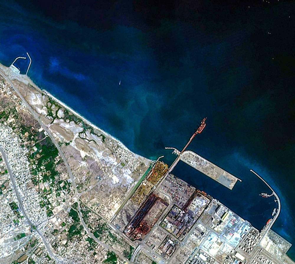
The Port of Sohar and parts of Sohar Freezone

The Port of Sohar and parts of Sohar Freezone

Omani company Etco Space launched its first satellite, the Aman-1 in November 2023. The satellite has captured its first images of Sohar Port and a mountainous range of the Western Hajar Mountains from Low Earth Orbit (LEO).

The satellite set off aboard Elon Musk’s SpaceX Falcon 9 rocket on 11 November 2023 from the Space Launch Complex 4E in Vandenberg, California, USA.

This development comes amidst Oman’s plans to develop Middle East’s first spaceport by 2030, which will be among the largest and most advanced in the world.

Named Etlaq – which means “launch” in Arabic – the spaceport will be able to host all sizes of launch vehicles in the port town of Duqm. It would meet US Federal Aviation Administration standards to attract international launch companies.

The Middle East is looking towards the space sector to diversify the economy, build indigenous capacity, and compete with the heavyweights in space worldwide. The region is currently witnessing an outpour of FDIs, government contracts, and a vibrant startup scene.

The current economic value of the region’s space sector is around $25 billion and is set to grow threefold by 2032, according to a report by Euroconsult.

Moon Landing Not Critical; Time to Fix Things on Earth: Portugal Space

0
Moon Landing Not Critical; Time to Fix Things on Earth: Portugal Space
Apollo 11 Moon Landing | Wikipedia Commons

While countries are vying to land on the moon, and extracting lunar minerals, the Portuguese Space Agency thinks differently.

“It is not critical for us to land on the moon or Mars now to see if there are some minerals that we can benefits from. There are other challenges to concentrate upon as we run out of time to fix things here on earth,” says Ricardo Conde, President, Portuguese Space Agency.

“What we will do in the next ten years will completely change the landscape of the next 50 years”.

Going to the moon and building bases is on part of most countries’ long-term agenda right now, though the Portuguese Space Agency is in no such hurry.

First Things First

The space landscape is rapidly changing with the focus on developing human spaceflight capabilities. However, Portugal doesn’t want to join this race.

“I would not like to jeopardize any national program just to have an astronaut from the Portuguese Space Agency. This is the reason why we are part of the European Space Agency. They have their corp of astronauts. We are focusing on the things that space must deliver, not on the exploration of the moon,” he adds.

He believes there are other issues to take care of such as space debris management, sustainability challenges, and Climate Change mitigation.

“Our participation as a space agency is to concentrate on the existing terrain and our progress is very focused on Earth”.