Home 2023 July

Monthly Archives: July 2023

Metamag announces Solution for GPS Interference

0
Metamag announces Solution for GPS Interference

Metamag announces Solution for GPS Interference

Metamagnetics, a provider of RF system solutions for the aerospace, defense and commercial communications industries, has announced its unique solution for addressing GPS interference in congested and contested environments.

Dr. Reena Dahle, Product Development Manager and Principal RF Engineer at Metamag, recently presented the company’s Autotune Filter (AtF) solution for global positioning system (GPS) applications at the IMS Conference in San Diego. The IEEE International Microwave Symposium (IMS) is one of the leading events for industry, government and academic stakeholders worldwide in the RF and microwave space.

AtF technology can reject unwanted signals, allowing operators continuous access to GPS signals. It accomplishes this by automatically suppressing interfering signals that exceed designed power threshold and can simultaneously operate on any number of interfering signals. AtF products are characterized by low size, weight and power, a passive configuration (zero power consumption) and are easily retrofittable.

“Reliance on GPS networks represents one of the greatest national security risks today,” said Dr. Dahle. “A vast number of consumer, industrial, and military devices rely on GPS as the gold standard for precise positioning, navigation and timing, affecting billions of users worldwide. We are focused now on rolling out and integrating this technology for key customers in the defense, space and commercial industries.”

China and Egypt Forge New Space Partnership

China and Egypt Forge New Space Partnership

China and Egypt have joined hands to embark on a significant collaborative venture in the field of space technology. This partnership of two satellite prototypes and one flight model marks a crucial step for Egypt’s space industry ambitions, as China provides the necessary support and funding for this project. The collaboration holds great promise for both nations, showcasing their commitment to advancing scientific exploration and diplomatic ties.

China’s Satellite Assistance through the EgyptSat Project

At the heart of this partnership lies the EgyptSat project, a satellite program designed to bolster Egypt’s Earth observation capabilities. China has committed to funding the project, which involves the construction and launch of two high-resolution Earth observation satellites. Egypt has taken the delivery of two China-funded prototypes for the MisrSat-2 satellite. These satellites will play a crucial role in monitoring Egypt’s natural resources, managing urban development, and enhancing disaster response capabilities. The satellites will be assembled and tested at a centre, which is near the new capital, New Administrative Capital, at the Egyptian Space Agency. China provided a US$74 million grant for the project, as well as US$68 million for the satellite assembly, integration and test centre to be built.

Instead of offering multi-utility projects involving satellite manufacturing, launch, and financing, China is now emphasizing technology transfer and knowledge-sharing. By sharing its expertise, China aims to assist Egypt in developing its own capabilities in satellite assembly and testing. This approach aligns with China’s strategic Belt and Road Initiative, which focuses on infrastructure development and cooperation with partner countries.

Boosting Egypt’s Development with the Africa-China Space Cooperation

China’s involvement in Egypt’s space industry aligns with its broader ambitions of becoming a leading player in the global space arena. Over the past decade, China has made significant strides in space exploration, including successful manned missions, lunar landings, and the development of advanced satellite systems. By partnering with Egypt, China showcases its ability to provide comprehensive support to nations seeking to develop their space capabilities.

For Egypt, collaboration with China brings numerous advantages. Apart from financial support and technical expertise, the partnership will facilitate the transfer of knowledge and skills, empowering Egyptian scientists and engineers in the field of space technology. This transfer of expertise will have a broader impact on Egypt’s overall scientific and technological development, creating opportunities for innovation and fostering economic growth.

China’s partnership with Egypt in the space sector is part of a broader trend of increased collaboration between China and African nations. Over the years, China has been actively engaged in space-related initiatives, including satellite launches, capacity-building programs, and joint research projects in several different countries including Belarus, Laos, Venezuela, Bolivia, and Nigeria.

The project with Egypt represents a shift toward technology transfer and knowledge-sharing, following examples set by other countries like South Korea and the UAE. Ian Christensen, director of private sector programs at Secure World Foundation, noted that China’s engagement with Egypt is part of its broader economic and diplomatic interests in Africa, where it has been actively building relationships and investing in infrastructure development.

Furthermore, China is exploring similar partnerships with the United Arab Emirates, which has announced ambitious space missions one like Emirates Mars Mission, also known as Al Amal, a project to send the Arab world’s first mission to the red planet. This reflects China’s interest in establishing relationships and gaining access to developing markets in Africa.

ALSO READ: PhilSA Takes Action to Mitigate Space Debris Threat

Sky is the Limit

0
Sky is the Limit

It is often said in a light-hearted manner that geospatial applications is a solution in search of problems! Indeed, the spread of geospatial applications from natural resources management to city management, to healthcare and more is perhaps an indicator of its versatility. David Schell of Open Geospatial Consortium remarked that geospatial applications are only limited by our imagination.

Business Intelligence has been integrated with geospatial systems for applications such as warehouse and store locations, understanding customer preferences through demographic mapping and routing delivery vehicles, to name a few. In retail, the use of location and routing has been used for delivery from brick-and-mortar and online stores, food aggregators, taxi aggregators and other such B2C applications.

Real estate dealers have used both geospatial and BIM to present property details online such as location, 3D view from location, 3D property details at various levels, etc. The insurance industry also uses location and other details to calculate property valuation and insurance. The government also uses such data to determine property tax.

Beyond these, new areas are opening up as e-commerce and online retail gets more popular. In-store location is one such application that can lead customers to their desired products as well as to advertise new ones. One of the most interesting ideas is to use cosmic particles that can penetrate buildings as a medium of communication for locations where GNSS signals fail.

The new kid on the block is Metaverse which allows a customer to directly interact with a store and ‘try out’ designs on a virtual persona, an avatar, of the customer before buying. Physical location of the store is not a limitation but a delivery or physical pick up from a nearby location requires location and routing assistance through geospatial systems.

Metaverse will also improve on property deals as it enables the avatar of the prospective buyer to actually be on the location and walk around while talking to the dealer’s avatar. Again, on a lighter note – will avatars also be able to touch, feel, taste and smell? Quite an ask but who knows?

While these applications are realities or will soon become realities, there is always a fly in the ointment. As technology progresses, it enables many facilities, but it also facilitates crime. The protection of legitimate customers, and safeguarding the privacy of their data becomes a paramount concern.

This aspect needs to be addressed in sync with the new applications. Do geospatial systems have a role to play in this area of personal security?

German Startup Uses AI, IoT for Railway Infra Optimization

0
German Startup Uses AI, IoT for Railway Infra Optimization
KONUX IIoT Device
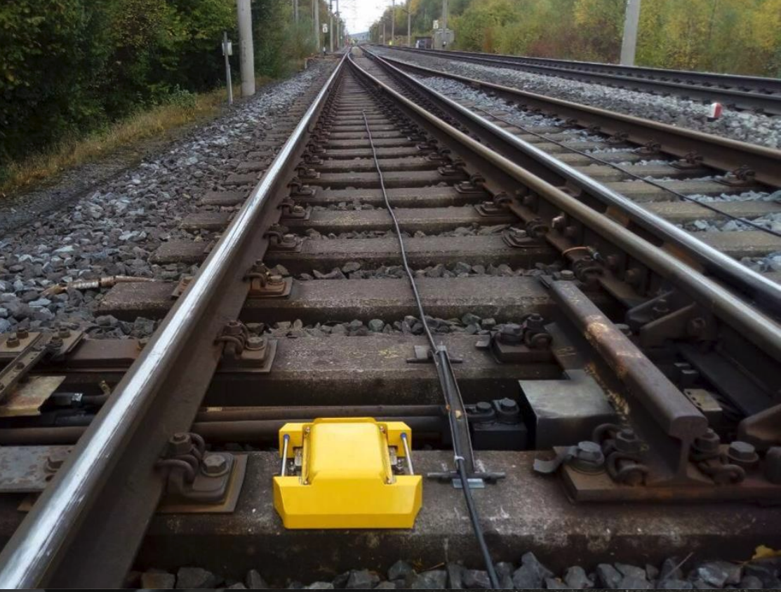
Konux’s IoT device where it’s able to monitor the condition of a railway switch (Image credit: Konux)

Konux, a Munch-based deep tech AI scale-up, has been building out a SaaS business powered by proprietary sensing hardware and AI that drives a predictive maintenance software-as-a-service(SaaS) play which is upgrading railway infrastructure as reported by Techcrunch.

Its mission is to drive digitization and transformative change atop rail travel, using AI plus IoT to add intelligence to fixed rails by capturing real-time data on what’s happening on and to the railway network.

“The core problem is something that actually is a dirty problem,” says Konux CEO Adam Bonnifield as told to Techcrunch, discussing what makes this AI business different from the ones hogging most of the global limelight right now.

“It’s not one of these clean, AI model-building totally digital problems. It’s the dirty problem of getting sensors to survive the environment, extracting the data, making sense of it, fitting it within the business problems, with the customer, and then bringing along the organisation on a journey through a bunch of organisational changes.

The company is using deep tech methods and stress-tested connected hardware to gain visibility into the loads and forces railway lines are accommodating day in, and day out;  measuring vibration through the tracks to pick up anomalies that may signify failures incoming, then presenting its probabilistic analysis of what’s going to happen to the infrastructure over the next few months.

Its AI-driven predictions were developed to a 90% accuracy standard, per Bonnifield.

In addition to predictive maintenance, Konux’s AI + IoT approach supports rail operators with further business intelligence around network traffic and usage; plus support with scheduling.
It offers three products
  • Konux Switch (predictive maintenance)
  • Konux Network (usage monitoring and inspection planning)
  • Konux Traffic (smarter timetabling)

The idea is to leverage AI and IoT to power data-driven decisions that can drive optimization around other aspects of rail operation, expanding out from Konux’s first focus on tracking infrastructure stress at key points on the network.

Digital Map Library for NZ city underground pipes

0
Digital Map Library for NZ city underground pipes

Wellington City Council, New Zealand, has approved an initiative to build an updateable digital map, recording where all of the underground pipes and cables are beneath the city’s roads and footpaths. The goal is to build a system and support compliance policies that can be scaled up for the whole of New Zealand.

The Wellington Underground Asset Map (WUAM) programme will revolutionise the way buried infrastructure like Three Waters assets, telecommunications cables, gas pipes and other services are installed, maintained, operated and repaired.

The programme aims to reduce disruption to the capital’s streets by moving away from legacy records and outdated paper processes to a centralised online map-based library. It could form the start of a long journey towards a digital twin of the infrastructure under the city’s streets.

“Over the next few decades, billions of dollars will be spent on infrastructure projects around the city, including water, electricity, Let’s Get Wellington Moving, cycleways and Council capital projects like the Te Matapihi Central Library and housing developments,” said Siobhan Procter, chief infrastructure officer.

According to the council, the objective of the programme is to develop a federated data-sharing platform showing subsurface infrastructure owned by the council and other utility operators. These users will feed their data into this platform that everyone who works in the sector can access 24 hours a day, seven days a week.

“The Wellington Underground Asset Map will play a central role in making sure the variety of projects remain on track – reducing the impact on Wellingtonians and helping the city continue to function as we focus on making the city a great place to live, work and play,” added Proctor.

Teledyne e2v Space Imaging celebrates sensors success as Aeolus de-orbits

0
Teledyne e2v Space Imaging celebrates sensors success as Aeolus de-orbits

Aeolus is the fifth satellite in ESA’s Living Planet Program and has become one of the highest, impact-per-observation instruments in existence. The sensor is capable of observing Earth’s surface weather systems and into the stratosphere, 30 km high.

The data from the Aeolus satellite observations have been used to improve weather forecasts and climate models. They have also been used for tracking Saharan dust storms and enabling a better understanding of plumes from volcanoes. The Aeolus mission has paved the way for future operational meteorological satellites dedicated to studying Earth’s wind profiles.

The Teledyne team manufactured a bespoke sensor for Aeolus with a novel design specifically for this application. The sensor collects many signals from different altitudes, enabling Aeolus to measure wind speed at different heights throughout the atmosphere.

The Teledyne e2v Space Imaging team continue to specialize in bespoke detectors to meet the ever-increasing number of Earth Observation missions.

Paul Jerram, Chief Engineer, Teledyne e2v Aeolus team said, “The Teledyne Space Imaging team have enjoyed being part of this successful demonstrator mission which has far exceeded expectations. We look forward to building a detector with improved performance for the Aeolus-2 follow-up mission. We are proud to have assisted most of the world’s weather forecasting agencies in improved accuracy of long-range forecasts.”

Indian Aerospace Company Bags OMC Mapping Project

0
Indian Aerospace Company Bags OMC Mapping Project

Garuda Aerospace, India’s drone manufacturing company, has secured a substantial order of 400 Agri Kisan Drones from Indian Farmers Fertilizer Cooperative Limited (IFFCO). This achievement takes Garuda Aerospace’s order book tally to 10,000 drones for this year.

The collaboration between Garuda Aerospace and IFFCO aims to revolutionize the agricultural sector by introducing the Garuda Kisan Drone at the IFFCO Drone Yatra in the state of Karnataka. These state-of-the-art drones will enable farmers to utilize Nano Urea spraying through Precision Agriculture Drones, maximizing their efficiency and productivity.

IFFCO has launched a nationwide campaign to procure 2,500 ‘Kisan Drones’ as spray solutions for their revolutionary products, Nano Urea and Nano DAP. This ambitious initiative not only supports the development of around 5,000 rural entrepreneurs trained in drone spraying but also promotes sustainable agriculture and holistic cooperative development, contributing to the upliftment of the rural economy.

Agnishwar Jayaprakash, Founder and CEO of Garuda Aerospace,said, “Through our collaboration with IFFCO, we are revolutionizing the agricultural landscape by introducing the Garuda Kisan Drone. Our mission at Garuda Aerospace has always been to empower farmers with innovative technology, and the launch of these drones in Karnataka is a significant step towards achieving that goal. We aim to enhance crop yields, reduce costs, and promote sustainable farming practices by incorporating precision agriculture and Nano Urea spraying. We are proud to be at the forefront of this transformative journey, and we remain committed to empowering farmers with the latest advancements in drone technology.”

OpenSpace Introduces New Product for BIM Technology

0
OpenSpace Introduces New Product for BIM Technology
OpenSpace BIM+ product - BIM Element Overlay feature
OpenSpace Introduces New Product for BIM Technology
OpenSpace BIM+ product – BIM Element Overlay feature

OpenSpace, the global provider of 360° reality capture and AI-powered analytics, introduced OpenSpace BIM+, a suite of easy-to-use 3D tools that helps field teams and Virtual Design and Construction (VDC) teams get work done faster by unlocking BIM coordination on the jobsite. Announced at its Way

point customer conference, this is the third product from OpenSpace that uses technology to empower project teams to get things done faster, together. OpenSpace Capture, introduced in 2018, is used to fully document construction sites in over 93 countries, and OpenSpace Track, introduced in 2021, automatically quantifies progress on those sites. OpenSpace BIM+ adds to this portfolio with tools that accelerate BIM and field coordination workflows.

Working in both 2D drawings and 3D models is not new to OpenSpace customers. The popular BIM Compare feature in OpenSpace Capture allows field teams to navigate and compare site conditions to the project’s BIM, with the model fully aligned to the OpenSpace 360° capture. Last quarter, OpenSpace observed more than half its customers using this feature, and they represented the most active OpenSpace customers.

Neel Sheth, Vice President of Product at OpenSpace said, “Our customers’ BIM usage in OpenSpace was outpacing the industry’s overall rate of BIM adoption. That told us that OpenSpace might be able to help drive BIM utilization for those teams that are adopting and investing in BIM. With OpenSpace BIM+, we have partnered with VDC leaders and their project teams to help them work with BIM as easily as navigating a Google Street View.”

OpenSpace BIM+ is an add-on product to its popular OpenSpace Capture product, with the following capabilities:

  1. BIM analysis tools: Navigating and analyzing BIM in the field often requires the time and expertise of a VDC manager. OpenSpace BIM+ analysis tools speed up this communication by allowing field teams to easily work in the BIM and compare that to what they are building. Any project team member can click and navigate to saved views in the BIM, review model elements overlayed within the 360° photos, and access the model from any iPhone, iPad, or Android device when offline. Point cloud data can also now be stored, viewed, analyzed, and shared in OpenSpace from mobile and terrestrial laser scanners and OpenSpace’s 3D Scan feature, bringing reality capture data to one central location.
  2. BIM coordination tools: Construction projects require tremendous coordination and OpenSpace BIM+ includes features designed to help teams quickly solve problems by aligning design intent with on-site conditions to speed up responses, approvals, and project schedules. OpenSpace Capture’s popular field note feature is now part of BIM workflows with OpenSpace BIM+, allowing field teams to add detailed images and notes during site walks or back at their desks. BCF file export is also included, enabling streamlined workflows with leading BIM coordination tools like Revizto, Navisworks, and BIM Track.
  3. Seamless model management: Keeping the BIM model up-to-date can help to streamline the design and construction process, as it ensures that everyone has access to the most current information. OpenSpace BIM+ makes it easy to manage updates to the BIM with Autodesk model import, support for multiple models, and model usage reporting.

While BIM has gained widespread adoption among design and engineering professionals, its use in the field has been limited, partly due to the complexity and skills required to navigate and understand the building information model.

“With the implementation of OpenSpace BIM+, our project teams will gain the ability to swiftly address inquiries directly from the field, significantly minimizing the time-consuming exchanges they encounter while resolving challenges,” explained Breawn Felix, Regional Support Services Manager at Swinerton.

Airbus invests in new Wing Development Centre for next-gen Aircraft

0
Airbus invests in new Wing Development Centre for next-gen Aircraft

Airbus invests in new Wing Development Centre for next-gen Aircraft

Airbus is investing in its UK innovation capabilities, with the opening of a new Wing Technology Development Centre (WTDC) at its Filton site. The facility, which will be used to build and test demonstrators for a range of programmes and research projects, was opened by Nusrat Ghani, UK Minister of State at the Department for Business and Trade.

The new facility will help Airbus accelerate the design, build and testing of wings for next-generation aircraft, by using the latest technology and world-leading demonstrators to further improve the performance of its wings.

Alongside engine optimisation, making wings longer, leaner and lighter is one of the biggest opportunities to improve fuel efficiency, reduce CO2 and ultimately work towards the aviation industry’s ambition to achieve net zero carbon emissions by 2050.

Airbus Head of Filton site and Wing of Tomorrow Programme Sue Partridge explains, “The new Wing Technology Development Centre will help us to ground our research in practicality. A key element of how we deliver technology for next-generation aircraft wings is through Wing of Tomorrow (WoT), our largest research and technology programme led by the team in the UK.

“Last week, we achieved a critical milestone in the programme when our second wing demonstrator was completed by the team in Broughton, Wales and delivered to the WTDC. Here it will be prepared for structural testing in our Aerospace Integrated Research and Technology Centre (AIRTeC).”

The WoT programme allows Airbus to explore new manufacturing and assembly technologies so future generations can continue to benefit from flying.

“It is about preparing our people, technology, industrial system, supply chain and digital and physical capabilities for next-generation aircraft. We are leveraging industry partners and the very best digital tools and automation to identify potential technology bottlenecks that may slow us down in the future. The foundations we lay now will help us build better and faster when the time comes.”

The WTDC adds to Airbus’ existing research and technology footprint in the UK, including the Advanced Manufacturing Research Centre (AMRC) in Broughton and both the ZEROe Development Centre and Aerospace Integrated Research & Test Centre (AIRTeC) at its Filton site.

SpaceX Launches Euclid Space Telescope for ESA

0
SpaceX Launches Euclid Space Telescope for ESA

SpaceX Launches Euclid Space Telescope for ESA

European Space Agency (ESA) successfully launched the Euclid Space Telescope on 1st July. The telescope was lifting off from Space Launch Complex 40 at Cape Canaveral Space Force Station.

It was launched with the help of the SpaceX Falcon 9 rocket. The Falcon 9 first-stage engines burned for just over two-and-a-half minutes before stage separation and eventual ignition of the single Merlin 1D MVac second-stage engine, which performed a burn for just over five minutes.

Euclid will take a month to travel through space to its operational orbit, Lagrange Point 2. The ESA expects to share the first images later this fall. The space telescope will help in creating a 3D map of the universe. It will also be capable of seeing as far back as 10 billion light years.

What are the Different Types of Geospatial Datasets?

What are the Different Types of Geospatial Datasets?

Spatial data or Geospatial data describes any data related to or containing information about a physical object that has shape, size, and particular location on the Earth’s surface and can be represented in a geographic coordinate system. In simple words, data which is collected through physical real-life locations such as towns, cities, countries, islands, etc. is known as spatial data.

The data consists points, lines, polygons, and other geographic and geometric data primitives, which can be mapped by location, and used by a communication system to identify a particular location. By leveraging the power of geospatial data, people can make better and more informed decisions.

Types of Spatial Data

Not only location-specific information, but it also consists of other types of data like 3D Point Cloud data, LiDAR data, etc. Spatial data can be classified as:

Vector Data

Vector data is a geographical representation of the world via geometric objects such as points, lines, and polygons. A line is created by connecting points and then by connecting lines, it creates an enclosed area that is called a polygon. Vectors represent the general structure of objects on the Earth.

Raster Data

Raster data talks about multidimensional images from satellites, drones, and other kinds of camera sensors. Raster data is a data type where data is stored in matrix of pixels organized into rows and columns. It refers to imagery such as aerial photographs, imagery from satellites, digital pictures, and scanned maps.

2D Spatial Data

To identify the exact location on the Earth, a geographic coordinate system is used a two-dimensional data surface. In geometry, it is the x-axis and y-axis but in geography, it is latitude (horizontal lines that run north-south) and longitude (vertical lines that run east-west). This 2D spatial data is mainly used in floor plans. The simplest example of it is Google Maps which uses geometric spatial data to provide accurate directions.

3D Point Cloud Data and LiDAR

There is also another type of data that is called 3D point cloud and LiDAR data. To collect LiDAR data, laser light is transmitted from a transmitter to an object. The light gets reflected from the objects. In this process, the time of flight is used to develop a distance map from the object. 3D data is the data that gathered information from the real world with x, y, and z coordinates. 3D data is very helpful in providing information. It can be used to solve many problems happening on Earth’s surface. 3D and LiDAR data is used in shoreline mapping, hydrographic surveying, emergency response, and coastal vulnerability analysis.

Spatial data has a significant role to play in different domains. It helps in IoT (Internet of Things) to use remote sensing for data collection. During natural disasters, geospatial data helps to analyze which area is more affected. In transportation and logistics, it is used to analyze specific routes, make accurate time estimations, and for delivery tracking in real-time.

Knowing Customer Behavior with Location Data

Knowing Customer Behavior with Location Data

We provide data to multiple industries, mostly about places, shapes, and activity, to companies from advertising, retail, FMCG, insurance, and even energy to better understand customer behavior. We collect many datasets, including info about physical places and a point of interest dataset. We have coverage of more than 60 million places worldwide, with a strong presence in the EU, the US, and Canada. We contextualize datasets with shapes, so we have datasets that are a 2D representation of a place on a map, informing about the location’s square footage as well. Last but not least, we are adding the activity part to it, helping companies understand how people interact with different locations and places, which is about the number of visitors and what people do in the real world, tells Adam Ejsmont, Co-Founder & COO, Echo Analytics.

Kinetica Transforming Claims Management

Kinetica Transforming Claims Management

Insurance companies face the challenge of efficiently managing claims during catastrophic weather events. The response to these events can greatly impact the experiences and financial performances of policyholders and insurers.

Leveraging data and analytics, Kinetica collaborates with some of the largest insurance providers worldwide to revolutionize claims management by enabling real-time data processing.

Industry Challenge

Insurance companies must provide fast and accurate claims management services in response to weather-related incidents. Traditional approaches often struggle to handle the scale and speed required to process and analyze vast amounts of data.

Batch & Summarised Data

Traditional approaches also struggle with timely analysis of detailed data as they come in summarized versions in batches as shown below. So it’s a geospatial problem at its core, as catastrophic weather events are polygons and insured properties are also polygons as different areas will have different damage.

Real-Time Data Analysis

Real-time & Detailed Data

With Kinetica, insurance companies can visualize and analyze data in real-time. A map overlay feature enables the visualization of real-time weather events and policy liabilities, allowing insurers to identify areas affected by specific weather conditions. The data shown below is detailed and real-time.

Geospatial Solution Overview

Kinetica provides insurance companies with a comprehensive solution to transform their claims management processes. The solution incorporates data from multiple sources, including policy datasets and the National Weather Service Alerts. By fusing these datasets, insurers gain valuable insights into policy liabilities, building footprints, materials, and structural types.

Seamless Integration of Machine Learning Models

By leveraging Machine Learning algorithms, Kinetica provides estimates of affected policyholders and liabilities, enhancing decision-making processes

Insurers can deploy their predictive models within the Kinetica environment, eliminating the need for separate systems. This streamlined approach reduces latency and ensures a reliable and efficient claims management system.

Comprehensive Data Aggregation and Summarization

Kinetica’s solution aggregates and summarizes vital information related to policy data, structure types, exterior materials, and roof materials. The platform incorporates weather event data, including event certainty and severity.

This consolidated view enables insurers to understand the impact of weather events on building footprints and associated policies.

Advanced Visualization and Interactivity

The company offers advanced visualization capabilities to facilitate decision-making. The platform presents affected building footprints on a map, color-coded based on their roofing materials.

Users can zoom in to examine individual footprints and access detailed information, such as building geometry. With the server-side rendering of billions of data points, Kinetica ensures a high level of fidelity and interactive data exploration.

Example of Real-time Weather Data Processing and Visualization Flow

In the above image, real-time weather events and policy data are ingested using Amazon Kinesis and S3, respectively. The changing weather data is fused with building footprint data in real time, employing geo-joins and temporal joins. Containerized Sagemaker ML models are then invoked to predict damage, severity, and liability in real time. Finally, the vast amount of data is visualized in real-time by sending WMS data to your preferred business intelligence tools using Postgres Wireline.

Support for Complex Geometries

Kinetica’s solution extends support to complex geometries, such as detailed polygons representing water bodies. By seamlessly handling overlapping geometries, insurers can accurately count the number of distinct properties affected by multiple weather events. This feature prevents double-counting and improves the precision of claims management.

Data Sets Utilization

Kinetica leverages various datasets to power its claims management solution:

  • National Weather Service Alerts: Includes event ID, timestamps, geometry, and additional details for each weather event.
  • Policy Datasets: Encompasses building footprints, types, roof pitch, and other building-specific details and geometries.

Results and Benefits

Through the claims management solution, insurance companies can achieve the following benefits:

  • Enhanced speed and accuracy in processing and analyzing real-time data.
  • Improved decision-making

DLRob AI Robot Controller Revolutionizes Autonomous Packing and Stacking

0
DLRob AI Robot Controller Revolutionizes Autonomous Packing and Stacking

Deep Learning Robotics (DLRob), an artificial intelligence and robotics technology company, announced in the framework of the Robot Tech Show 2023 last week the launch of its latest innovation, a feature in its vision-based controller that enables robots to autonomously pack and stack a wide range of objects with almost no setup time.

This system, protected by DLRob’s robust patent portfolio, represents a significant advancement in the field of autonomous robots.

DLRob’s AI robot controller is well known for enabling robots to learn from human demonstration. What sets this new feature apart is its ability to self-train using a unique combination of generated synthetic data and real performance data. By generating its synthetic data and merging it with its real-world performance data, the vision-based controller achieves remarkable adaptability and accuracy in handling diverse objects and placing them in optimal locations with little or no setup time. This means that no user demonstration is needed.

“We are thrilled to introduce this new feature of our vision-based robot controller, which marks a major milestone in the field of AI-powered robots and automation,” said Deep Learning Robotics’ CEO. “By leveraging our self-training approach, the controller gains an unprecedented level of proficiency, enabling robots to pack and stack virtually anything by finding optimal locations for each of the objects identified in the scene. This breakthrough has the potential to transform various industries, from logistics and warehousing to manufacturing and beyond.”

The new feature will be made available to a selected group of partners and clients in the upcoming months, with full availability planned for the next version of DLRob’s controller.

DLRob’s vision-based controller encompasses a multitude of cutting-edge technologies, including learning tasks by observing end users’ demonstrations, advanced human-robot interaction, and on-the-fly motion planning. The system intelligently analyses the shape and size of objects to optimize the packing and stacking process. Furthermore, it continuously learns from its own experiences, refining its performance over time to adapt to various scenarios and ensure consistent, error-free operations.

DLRob’s commitment to intellectual property protection is reflected in its robust patent portfolio. The company’s dedication to safeguarding its innovations reinforces its position as a leading provider of groundbreaking solutions in the robotics industry. By actively protecting its advancements, DLRob ensures that its customers benefit from the highest level of innovation and security.

With DLRob’s vision-based controller, businesses can unlock unprecedented operational efficiency, maximize productivity, and reduce costs. The autonomous packing and stacking capabilities empower organizations to streamline their processes without robotics engineering efforts, and meet growing variability demands with unmatched precision and reliability.

DLRob invites industry professionals, researchers, and technology enthusiasts to witness the power of its vision-based AI robotic controller at upcoming conferences and exhibitions. The company remains committed to pushing the boundaries of AI-powered robots and continuing to revolutionize the industry worldwide.

CPI Vertex to provide 20m antennas to KSAT for lunar missions

0
CPI Vertex to provide 20m antennas to KSAT for lunar missions

KSAT is investing in a purpose-built commercial network for lunar communications and has selected CPI Vertex Antennentechnik GmbH, a subsidiary of Communications & Power Industries, to provide three 20m diameter antenna systems.

Designed from the ground up to meet the requirements of upcoming lunar missions, these state-of-art antennas will be installed in three evenly distributed locations to ensure continuous lunar coverage.

The first antenna system will be operational by the end of 2025, and the full network by the end of 2026. KSAT Lunar’s 20m network will provide TT&C, payload downlink, and ranging services in both X-band and Ka-band.

The antennas are compliant with the requirements set by planned lunar relay satellite constellations, and by NASA for the Lunar Exploration Ground Sites (LEGS). The demanding technical and performance requirements and the need for uninterrupted lunar coverage have served as guidelines for setting the specifications to CPI Vertex.

“After a thorough process that started in 2021, CPI Vertex provided the best solution, based on our requirements. Their history and experience in building deep space antennas and radio telescopes played a key role in the decision-making,” says KSAT Product Manager for Lunar, Francisco Periales. “We are now getting all the building blocks together and the next step is to onboard our customers.”

As humanity sets its sights on the Moon with renewed enthusiasm, KSAT is committed to providing unparalleled support and infrastructure to enable ground-breaking missions and scientific endeavours, including the return of humans to the Moon through the Artemis program. We believe that by offering reliable and efficient communication infrastructure, we can unlock the full potential of the Moon as a platform for scientific research, resource utilisation, and sustainable human presence.

“The KSAT lunar communications network represents the next stage in space communications technology. It is a challenging and visionary program, and CPI Vertex has worked closely with the KSAT to ensure that we can deliver a reliable, advanced technology solution with our full-motion dual-band antenna systems that will help ensure the program’s success,” says Gerbert Lagerweij, Director Sales & Marketing, of CPI Vertex Antenenntechnik.

Rivada Space Networks Joins an Initiative for Global Space Sustainability

0
Rivada Space Networks Joins an Initiative for Global Space Sustainability
Rivada's OuterNET offers unprecedented coverage, capacity and speed.

Rivada Space Networks Joins Astra Carta Initiative for Global Space Sustainability
Rivada’s OuterNET offers unprecedented coverage, capacity, and speed.

Rivada Space Networks has joined the Astra Carta initiative to accelerate space sustainability. Launched by the Sustainable Markets organization, Astra Carta brings to reality a vision for space sustainability outlined by His Majesty King Charles III, when he was the Prince of Wales, at the UK Government’s Summit for Space Sustainability in 2022.

Ann Vandenbroucke, Chief Regulatory Officer at Rivada Space Networks said, “We are already working with OKAPI: Orbits to provide our constellations with satellite mission-analysis tools and collision avoidance and de-orbiting strategies, demonstrating our commitment to using space responsibly and applying the highest standards in terms of space sustainability and debris mitigation.”

Rivada Space Networks will soon be launching an LEO constellation, which will offer access to a secure satellite network with pole-to-pole reach, with end-to-end latencies similar to or better than terrestrial fiber. Rivada’s unique system architecture creates the first true “OuterNET” by combining inter-satellite laser links with advanced onboard data routers to create a global mesh network in space. It will deliver ultra-secure and highly reliable global connectivity for business operations in the telecom, enterprise, maritime, energy and government services markets. The first satellite launch is set for 2025, with global service starting in 2026.

Declan Ganley, CEO, Rivada Space Networks said, “We are building something unique in low earth orbit, the OuterNET: the first truly private global network on which data travels through space alone to provide ultra-secure, highly reliable low latency communications anywhere on the globe.” He added: “We will continue to work very closely with the global space community to ensure the responsible use of space and the success of this ground-breaking satellite constellation.”

Amazon Rolls Out First Electric Delivery Vans from Rivian in Europe

0
Amazon Rolls Out First Electric Delivery Vans from Rivian in Europe

Amazon announced the arrival of its new custom electric delivery vans from Rivian in Europe, with the first vans rolling out in Germany. More than 300 electric delivery vans are hitting the road in Munich, Berlin, and Dusseldorf in the coming weeks, joining a fleet of thousands of electric vans already in operation in Europe, including more than 1,000 electric vans in Germany. Amazon announced last year that it plans to invest more than €1 billion to electrify its European transportation network and reduce carbon emissions over the coming years, including more than €400M in Germany.

“Together, Amazon and Rivian designed and built a state-of-the-art electric vehicle from the ground up, and unlike anything else on the road today,” said Neil Emery, Amazon, Director, Global Fleet & Product. “The safety and comfort of our drivers were top of mind for us throughout this process, and we’ve raised the bar on both with the vehicle we are rolling out in Europe today.”

“We’re thrilled to see the EDV rolling out in Germany today,” said Dagan Mishoulam, Vice President, Strategy & Go To Market, Rivian. “This vehicle was designed in conjunction with our partners at Amazon and not only puts driver convenience and safety first but also the environment. We’ve had incredible feedback from drivers in the US and we’re excited to start international expansion in Germany. Today is a real milestone for us as it also marks the first Rivian vehicles in Europe and we’re very excited about our future in the region.”

“Amazon is committed to reaching net-zero carbon by 2040, and reducing our delivery-related emissions is a critical part of this goal,” said Rocco Bräuniger, Country Manager for Amazon.de. “Last year we delivered more than 45 million packages in Germany with electric vans and e-cargo bikes, and these new additions from Rivian will help us deliver packages more sustainably and to more customers.”

Amazon began rolling out its custom electric delivery vans from Rivian in the U.S. last summer and already has more than 3,000 vans delivering packages in over 500 U.S. cities and regions. The company aims to have 100,000 electric delivery vehicles from Rivian on the road globally by 2030, helping to save millions of metric tons of carbon per year.

Amazon’s custom electric delivery vans from Rivian are designed from the ground up with safety, sustainability, and comfort in mind, and have been thoroughly tested by drivers in Germany. They are the product of Amazon’s partnership with Rivian, which the companies announced in 2019 when Amazon co-founded and became the first signatory of The Climate Pledge—a commitment to reach net-zero carbon across its operations by 2040. As part of the pledge, Amazon is creating a more sustainable delivery fleet—and its work with Rivian is an important part of decarbonizing its last-mile logistics as well as accelerating innovation that could help others reach net-zero carbon.

Amazon has been testing deliveries with Rivian preproduction vehicles in Europe since last year. This testing has allowed Rivian to continuously improve the vehicle’s performance, safety and durability in various climates and geographies as well as its state-of-the-art features to ensure driver satisfaction, and overall functionality. In Europe, Amazon and Rivian specially designed a shorter, thinner van than its U.S. counterpart in order to better fit in Europe’s cities.

The custom vehicles include innovative technology and features such as:

  • A safety-first design focused on superior 360-degree visibility and vehicle features that protect drivers and pedestrians.
  • A suite of innovative safety features including a large windshield to enhance driver visibility, automatic emergency braking, adaptive cruise control, and collision warnings.
  • First-of-its-kind embedded technology that fully integrates the delivery workflow with the vehicle, enabling seamless access to routing, navigation, driver support and more.
  • Features to enhance the driver experience, and create ease on the road such as automatic door locking/unlocking as the driver approaches or leaves the vehicle and a powered bulkhead door that opens when drivers reach their delivery location.
  • A strengthened door on the driver’s side for additional protection, and an ergonomically designed driver’s cabin and cargo area for safe, and easy movement inside the van.
  • Batteries that are light, resilient, and low cost in addition to lasting the lifetime of the vehicle.

Amazon has added thousands of charging stations at its facilities across Europe and will continue to invest in building an infrastructure to support a more sustainable delivery fleet.

In 2022, Amazon used zero-emission vehicles, including electric vans and micro-mobility solutions like e-cargo bikes, e-scooters, and walkers, to deliver more than 120 million packages to customers in Europe. The new vans from Rivian, along with the expansion of micro-mobility hubs across European cities, will help Amazon deliver even more packages in zero-emission vehicles.

UAE Cabinet approves testing of self-driving vehicles

0
UAE Cabinet approves testing of self-driving vehicles
TXAI is the self-driving fleet in the UAE. WeRide, which provides the software and hardware solutions for Level 4 autonomous driving technologies, was approved to test its self-driving system on UAE roads. Image Credit: TXAI

TXAI is the self-driving fleet in the UAE. WeRide, which provides software and hardware solutions for Level 4 autonomous driving technologies, was approved to test its self-driving system on UAE roads. Image Credit: TXAI

The UAE has authorized the first license for self-driving cars to operate on its roads. The approval was given at a Cabinet meeting chaired by His Highness Sheikh Mohammed bin Rashid Al Maktoum, Vice-President and Prime Minister of the UAE and Ruler of Dubai, reported by Gulf News.

The license has been granted to WeRide company which will test different types of self-driving vehicles. This was the first license of its kind for autonomous vehicles in the UAE.

The national policy for electric vehicles was also approved in the Cabinet, which includes building a network for electric vehicle charging devices, regulating the EV market, and stimulating related industries to ensure the reduction of emissions, reduce energy consumption, among others, according to Gulf News.

Sheikh Mohammed has also approved an updated national energy strategy to cope with rapid changes in the energy sector and increase the contribution of renewable energy three folds within the next seven years.

DATAMARK to Provide GIS Training to New Mexico Bureau

0
DATAMARK to Provide GIS Training to New Mexico Bureau

DATAMARK, the public safety GIS team of Michael Baker International, announced that the firm has been selected by the New Mexico E9-1-1 Bureau to provide Next Generation 9-1-1 (NG9-1-1) GIS training to Public Safety Answering Point (PSAP) and GIS leaders throughout the state.

DATAMARK kicked off a recurring series of GIS and addressing best practices training sessions at the New Mexico Association of Public-Safety Communications Officials (APCO) / National Emergency Number Association (NENA) Conference in Las Cruces, New Mexico, in May 2023.

“New Mexico joins many other states in taking a thoughtful and proactive approach to NG9-1-1 education for the state’s PSAPs, having recognized that early education and planning is crucial to the Bureau’s success,” said Robert Murphy, Director of Business Development at DATAMARK, Michael Baker International. “Our DATAMARK team will draw on extensive educational outreach and experience with successful NG9-1-1 projects to support New Mexico in raising awareness and understanding of the key elements of a successful NG9-1-1 transition. This project will lay the foundation through valuable knowledge-sharing and training on NG9-1-1 GIS processes and workflows.”

New Mexico joins a growing list of statewide clients turning to DATAMARK for complex and diverse NG9-1-1 GIS services. This includes the Alabama 9-1-1 Board, State of Idaho, State of Oklahoma, State of Maine and local governments in twenty-two states.

“DATAMARK has demonstrated a thorough understanding of NG9-1-1 GIS needs and an ability to communicate those needs to a wide range of stakeholders, so our program is pleased to work with DATAMARK towards a NextGen solution,” said Tyler Fosset, New Mexico 9-1-1 GIS Coordinator.

The project includes the on-site facilitation of two different educational courses, Intro to NG9-1-1 GIS and NG9-1-1 GIS Transition. DATAMARK’s Intro to NG9-1-1 GIS course introduces PSAP and GIS leaders to NENA standards and best practices and will describe the workflows required to ensure that NG9-1-1 GIS data meets NENA standards to support geospatial call routing.

The NG9-1-1 GIS Transition course provides attendees with information to establish processes, describe the functions of NG9-1-1 systems, provide an intermediate understanding of GIS, discuss how Next Generation Core Services use GIS, and detail how data governance affects data completeness. Courses will be held throughout the state over the next several months to provide equal access to educational opportunities to all New Mexico PSAPs.

PhilSA Takes Action to Mitigate Space Debris Threat

PhilSA Takes Action to Mitigate Space Debris Threat
Philippine Coast Guard recovers a rocket debris in Bataan waters on June 5, 2023 PHILIPPINE COAST GUARD

The Philippine Space Agency (PhilSA) recently confirmed that debris recovered in Bataan a month ago is highly likely to be from a Chinese rocket, indicating a concerning space event. Following an investigation conducted by the PhilSA, experts have concluded that the recovered debris shares distinct characteristics with components used in Chinese rockets. The findings strongly suggest that the remnants originated from a Chinese launch vehicle.

This discovery raises questions regarding the responsible management of space activities and has prompted concerns about the safety and potential hazards associated with space activities. With the ever-increasing number of space missions being conducted by various countries, ensuring responsible practices and proper disposal of debris has become crucial.

The PhilSA, in collaboration with international space agencies, is closely monitoring space events to mitigate such risks and prevent future occurrences. Established in 2019 and operational by 2020, the PhilSA has been actively addressing the challenges of space sustainability. The agency emphasizes the importance of responsible space exploration and the need for international cooperation in maintaining the sustainability of outer space.

The recovery of this debris serves as a reminder of the significance of space situational awareness and the urgent need to address the challenges posed by space debris. PhilSA remains committed to promoting scientific research, technological advancements, and international collaboration to ensure the peaceful and sustainable use of outer space.

In a conversation with Geospatial World, Noelle Riza Castillo, Director of the Space Policy and International Cooperation Bureau at the PhilSA, emphasized the significance of mitigating and managing space debris. As a lawyer by profession, Castillo joined the PhilSA in 2021 and has been at the forefront of the country’s space exploration endeavours.

Castillo highlighted the urgent need for appropriate guidelines to effectively respond to space debris resulting from foreign rocket launches.

Establishing National Protocols for Space Debris Management

In 2021, the agency formed a Technical Working Group on Orbital Debris Protocols. This advisory body focuses on coordinating discussions, formulating strategies, and integrating guidelines for orbital debris in the Philippine space region. The group comprises the PhilSA, local government authorities, Navy, and Air Force, each with its own set of protocols. By coordinating efforts, these agencies can effectively respond to emergencies and minimize the impact on affected communities.

One of the key priorities is the implementation of space object registration. Efforts are underway to raise awareness and encourage all countries to register their space objects with the United Nations (UN), ensuring transparency regarding satellite ownership, status, and usage. Another significant concern is the growing problem of space debris.

“In recent times, space debris has been falling into the Philippine seas, and they have been discovered by our fishermen in fishing waters near our communities. As a nation, we have responded domestically by creating a multi-agency task force or working group to address these situations,” said Castillo.

While the Philippines is not yet a spacefaring nation, it has satellites in orbit. The debris from rocket launches, primarily from China, often falls into Philippine seas and is discovered by local fishermen. In response to this domestic challenge, the PhilSA has established a multi-agency task force and working group on Orbital Debris Protocols. The aim is to develop national protocols on how to respond to these situations effectively.

Coordinated Efforts to Safeguard Philippine Territories and Communities

Considering the archipelagic nature of the Philippines, where debris can potentially fall on any of the country’s 7,000+ islands, a coordinated approach involving local governments, aviation authorities, and the space agency is crucial. To enhance response capabilities, the PhilSA has been collaborating with various stakeholders to create unified guidelines.

However, one of the major obstacles lies in being aware of rocket launches in advance, as notifications are often insufficient or provided on short notice. Efforts are being made to decipher launch information through civil aviation notice data or format.

Regarding the local population, including fishermen in affected areas, the PhilSA strives to inform them promptly once a rocket launch is detected. This includes plotting the projected debris path and communicating the potential impact to communities. However, Castillo emphasized the importance of transparency on the part of launching states to prevent such incidents.

“There is a need to coordinate with each other on how to respond as soon as we become aware of a rocket launch that will pass through our territory. The current challenge lies in obtaining awareness of the rocket launch since the notices are not being provided transparently,” said Castillo.

By manoeuvring spacecraft away from local communities, the risk of debris falling on inhabited areas can be significantly reduced.

As space becomes more congested with satellites and the influx of new space players, the PhilSA remains committed to keeping the local population informed about potential risks. Immediate communication with communities is essential, and the agency’s technical working group plays a vital role in disseminating critical information. By analyzing debris trajectories and identifying areas at risk, the PhilSA strives to ensure the safety of its citizens.

The efforts and initiatives undertaken by the PhilSA reflect its commitment to addressing the challenges of space debris and ensuring sustainable practices in the country’s growing space industry. Through collaboration, coordination, and the formulation of comprehensive protocols, the agency is taking proactive steps to protect its territories and communities from the hazards associated with space debris.


WiMi Hologram Cloud Develops Human-Robot Collaboration System

0
WiMi Hologram Cloud Develops Human-Robot Collaboration System

WiMi Hologram Cloud Develops Digital Twin-based Human-Robot Collaboration System

WiMi Hologram Cloud, a global Hologram Augmented Reality Technology provider, announced that its R&D team is developing a human-robot collaboration system based on digital twin technology. The system aims to stimulate human potential, enhance human skills with humans at the core, and realize the integration of human-robot collaboration.

The system supervises and predicts the digital model of humans and robots by mapping the twin objects of humans and robots in the physical and digital worlds. By accumulating knowledge of human-robot collaboration skills, experiences, and interaction characteristics, the system can coordinate the construction of decision-making and innovation mechanisms. The system integrates the flexibility and adaptability of humans and the efficiency and accuracy of the robots to promote a qualitative leap and development of human-robot relationships.

Firstly, based on various physical sensing devices, the system will acquire human operation behavior’s image or video information. Then the system inputs this information into the perception system, extracts the multidimensional features of human behavior, and employs deep learning algorithms to solve the action strategy for the current state. In the decision system, the results of the perception are evaluated. The decision behaviors that satisfy the requirements are displayed through an interactive visual interface to guide human action selection through dynamic guidelines.

The next step is to construct a digital twin space, a real-time mapping of the physical entity space. The physical entity adopts the digital representation form to build its corresponding virtual model and simulate the behavior of the physical entity in the natural environment. The digital twin technology can enhance the implicit information expression of physical entities through the interactive feedback between the virtual and physical ends and the behaviors of data fusion, data analysis, and decision optimization.

While in the actual physical space, the human, robot, and environmental tasks are constantly interacting and iterating, and their related information data are transported to the twin space for optimization and computation, and real-time feedback is provided on the processing results. Through continuous iterative optimization, the performance of each system is improved so that the human-robot collaboration system can operate better.

The digital twin-based human-robot collaboration system developed by WiMi enables humans and robots to share, coordinate, allocate, and use resources and information in physical and information spaces through direct contact or indirect interaction. Based on the human-centered principle, the two share the right to control and make decisions about the system, execute system planning, and jointly improve skills to achieve work goals.

General Motors acquires Battery Software Startup ALGOLiON

0
General Motors acquires Battery Software Startup ALGOLiON

General Motors acquires Battery Software Startup ALGOLiON

General Motors announced that it has acquired substantially all the assets of Israel-based battery software startup ALGOLiON Ltd. for an undisclosed sum.

The acquisition was led by the newly formed Technology Acceleration and Commercialization (TAC) organization, a group within GM that works to identify emerging technology that can support GM’s leadership position in battery development through investments, acquisitions or partnerships.

ALGOLiON, which received early support from the Israeli Innovation Authority, was founded in 2014 by Niles Fleischer, Ph.D., and Alex Nimberger, Ph.D. The company has developed sophisticated software that uses data streams from EV battery management systems to help identify anomalies in cell performance to ensure proper vehicle health management and provide early detection of battery hazards including thermal runaway propagation events. Dr. Fleischer has more than 40 years of experience in the battery industry and more than 80 patents in the field, while Dr. Nimberger has deep military and civilian experience in all aspects of lithium-ion battery operating modes and effects analysis.

ALGOLiON’s software, coupled with GM’s internal capabilities and vast experience in delivering best-in-class products at scale, can greatly accelerate the time-to-market of a cost-effective early hazard detection system for the benefit of millions of GM’s customers worldwide.

“ALGOLiON has developed battery analytics and prediction software that will help General Motors deliver great performing EVs for our customers,” said Gil Golan, vice president, TAC.

The software uses sophisticated algorithms to identify miniscule changes that could impact battery health weeks earlier than other methods in use today without additional hardware or sensors all while the battery is still operating properly.

ALGOLiON employees, including the company’s founders, will remain based in Israel and join more than 850 employees at the GM Technical Center in Herzliya, Israel. The team will be led by Guy Daniely, senior engineering manager.

GM Israel is an integral part of GM’s Global Product Development Group, working on key vehicle programs toward GM’s vision for a future of zero crashes, zero emissions and zero congestion.