ElectraMeccanica Vehicles Corp. a designer and manufacturer of electric vehicles revolutionizing the urban driving experience, today announced cost-reduction initiatives to further streamline the business in order to better consolidate onshore manufacturing capabilities and operations at its newly-commissioned Mesa, Arizona headquarters. These steps will accelerate the Company’s path to profitability, by imposing a new level of fiscal discipline that preserves the ability to commercialize and scale operations while also eliminating excess costs.
The New CEO/interim COO Susan Docherty has led an ongoing, top-to-bottom review of the Company’s existing operations footprint; product portfolio; product development; investment; capital allocation; and employee skills, distribution and efficiency. While this review is ongoing, the Company currently has elected to resize its workforce, lowering its headcount by 98 positions. This reduces the employee base outside Arizona by 57% and improves operating costs by approximately $10 million annually. The Company notes that its balance sheet and market demand for the SOLO remain healthy.
Separately, the Company announced it had appointed Ms. Docherty to its Board of Directors effective December 20, 2022. Additionally, as another outcome of its top-to-bottom review of the business, ElectraMeccanica is postponing its Investor Day until June 14, 2023, in order to focus exclusively on near term execution and so that it can provide the most comprehensive possible review of its business and future plans to shareholders.
2022 has seen various natural calamities, from floods that plagued Pakistan, wildfires that spread across Europe to Russia-Ukraine war effect that had its impact around the world and extreme climate change to advances in space science. In this video you’ll see these events through satellite imageries.
The word ‘intelligence’ immediately conjures an image of dark-suited men in dark sunglasses with a tightly grasped briefcase. Geospatial Intelligence adds additional mystery in the form of secret imagery of missile sites.
Indeed the world of military intelligence and peaceful uses of satellite imagery were set so far apart that never the twain would meet. Advances in technology and resource management have changed that. Now the two not only meet but overlap.
Satellite imagery resolution has improved to a point where commercially available imagery can produce maps at the level of detail that is needed for city ward maps and rural cadastral maps, not to mention the detection and location of defence and offense assets.
Further, the term intelligence now encompasses both military and civil requirements. The need to be able to observe and track military activities also extends to the need for monitoring activities that are inimical to human life and nature.
Both need fast information transfer from acquisition to delivery via analytics. The need to track a band of terrorists is no less critical than to predict the path of a cyclone.
From detection to interdiction, and to prevention needs fast analytics. Data Science, AI, ML and Deep Learning are the tools. Some of these can work on the Edge and provide near real-time analytics.
An interesting demonstration of fast computing using satellite data on a Web Services platform on the Cloud has also established another possibility of fast information turnaround.
An old technology, ELINT has been given a new lease of life through RF sensors that can track dark vessels – ships that have switched off their AIS. This has been used to track ships involving clandestine operations which could include illegal breaching of sanctions as well as illegal fishing in protected waters.
Humanitarian crisis management in times of war and in times of natural or man-made disasters is another area where geo-intelligence plays an important role.
The most recent example is the ongoing Ukraine-Russia conflict where populations have been subjected to denial of food, health facilities and electric power. Locating such clusters and reaching them aids tests the capabilities of geospatial technologies.
Disasters due to violent weather events brought on by Climate Change have lent an impetus to the development of world weather Digital Twins which can then predict possible threats, particularly to vulnerable areas like low-lying islands and launch protection measures.
Geo-intelligence is the need of the times which have become very complex in terms of conflict between nations, between humans, and between humans and nature. Meaningful information can lead to thoughtful actions, which in turn can help humankind be at peace with each other and with nature.
People are evolving, so are technologies to accommodate their needs and comfort. The technologies that existed in the pre-pandemic era have been replaced with more modern ones equipped with modern amenities. Cities are getting smarter as well as sustainable with the adoption of technologies.
Now that efforts are being made to keep carbon emissions on check, and sustainable ways are being explored to keep the environment clean while meeting all the connectivity requirements, mobility trends are falling in place.
Economic and environmental factors such as rising fuel prices and economies shifting to greener and sustainable transportation to decrease the carbon footprint drive the micromobility market demand worldwide.
As the market grows, associated sub segments such as electric two wheelers fleet businesses and battery manufacturing, swapping, and charging infrastructure register concurrent growth.
Watch the video here:
Here are the top mobility trends that are going to change the way people travel, in 2023:
Shared mobility
McKinsey’s report forecasts that micromobility has the potential to reach a consumer-spending of $300 billion to $500 billion globally by 2030, which comprises of both shared and private micromobility.
The pandemic has slowed down the use of public transport drastically, however the sector is recovering and people are moving towards shared mobility option especially the two wheelers. e-kick scooters to e-bikes are becoming popular for small distances and last mile delivery purposes.
Moreover, organizations are also investing in developing infrastructure for their employees to share vehicles en-route to office, since the workforce is coming back to office.
Autonomous driving
The autonomous vehicle model is being adopted by many top auto manufacturers and suppliers to prevent and reduce road accidents, and to eliminate human errors. With the new and fast ways of connectivity entering the market like 5G, big data, human machine interface (HMI), integration of AV has become one of the most sought after technology.
As IDTechex highlights that autonomous trucks are on the cusp of real-world use, and next-generation sensor technologies are being deployed on vehicles.
They have also forecasted that the concept of robo shuttle-powered future will see small, shared vehicles will be able to operate more flexible than a bus.
Flying Taxis
Air taxis are going to revolutionize the way people commute. How? They are going to ease the transport infrastructure issues of growing cities and simplify congestions.
Developers believe that with safety certification and clearance in place, air taxis will provide pleasant, fast and efficiency in terms of travelling. They will also make emergency responders work easy and quick.
Reports suggest that the investment in the advanced aerial mobility sector has almost tripled in 2021-22 and according to Morgan Stanley, the global air taxi market is expected to reach $3.27trillion by 2050.
Electric vehicles
2021 saw a 35% increase in the number of electric vehicles (EVs) sold than those sold in the last five years combined and by November 2022, UK registered sale of more than 30,000 new EVs.
People are inclining more towards the eco-friendly options and so are the manufacturers to cut down their carbon emissions, to if not stop but reduce the effects of climate change. Automobile giants have recently started investing heavily in the electric models of their cars. In many countries the government is working on modifying the infrastructure to accommodate the future electric vehicles.
Reports suggest that by 2025, 20% of the total cars in the globe will be electrically run and by 2030, all the petrol run cars will be banned from use in order to reach net zero emissions.
Turbocharging
Since there is too much pressure on the fuel consumption and reduce carbon emissions, automobile manufacturers are looking for alternative methods to compensate the fuel demands with something better and efficient. This is where turbochargers have made their way to give new life to diesel engines and other gasoline engines.
One of the major advantages of turbocharging making it to the list of top mobility trends that we will see in 2023 is because it is able to faster the speed, make the engines perform better without damaging it.
According to Allied Market Research, the global turbocharger market is expected to garner $24.23 billion by 2027, growing at a CAGR of 5.3% from 2020 to 2027. The need for engine downsizing to reduce vehicle weight, government regulations, and improved engine performance and fuel efficiency drive the demand for turbochargers.
GenH2 is the leading Hydrogen Infrastructure Company with decades of experience researching, engineering, and producing technology solutions necessary for the Hydrogen Economy. Leveraging years of collaboration with the top hydrogen experts, the company focuses on the commercialization of CO2 free Hydrogen generation, liquid hydrogen storage, and dispensing.
GenH2, announced the launch of its ground-breaking LS20 Mobile Liquid Hydrogen System, an end-to-end liquefication and storage system. The innovative, mobile liquefaction unit offers a space-optimized, fully integrated liquid hydrogen solution to be used in a range of applications from transportation to energy backup to accelerating the use of liquid hydrogen through pilot projects and testing. It will also be utilized as a lab setting for testing material, insulation, thermodynamic properties, and use cases for their applications.
With a mission to provide light-scale infrastructure solutions for liquid hydrogen, GenH2 designed the LS20 with the capability of producing small amounts of liquid hydrogen in order to provide access to more hydrogen researchers and hydrogen industry players. The LS20 can produce between two and 20kg of liquid hydrogen per day, to provide liquid hydrogen at-the-ready, when and where it is needed. Twenty kg of liquid hydrogen contains nearly 2400 Megajoules of energy and can be readily stored and used within GenH2’s ultralight utility tank systems.
“The development of the LS20 has been a culmination of decades of experience and engineering within and in conjunction with NASA.Providing researchers and developers of hydrogen infrastructure with a modular, efficient way of getting their hands on liquid hydrogen is a vital requirement to advance the hydrogen economy,”said Jong Baik, Chief Technology Officer of GenH2.
The smallest liquid hydrogen mobile unit currently commercially available, the LS20 is self-sustaining and can run independently with a portable generator or plug into a building’s power source. This makes the LS20 ideal for dispensing fuel to multi-purpose drones and providing an emergency power supply to first responders. Additionally, the LS20 units are manufacturing ready to keep up with the increasing demand for hydrogen and enable faster infrastructure build-out and adoption. According to Baik, with its flexibility, compact size, and speed-to-market capabilities, the LS20 is a game-changer for a rapidly growing hydrogen industry.
The LS20 is designed for those areas where relatively compact systems are necessary to enable hydrogen viability. As a complete system, the LS20 can liquefy, store, and dispense liquid hydrogen from any gaseous hydrogen source, such as a storage tank or an electrolyzer. This compact, flexible system offers the user the ability to provide liquid hydrogen when and where it is needed. The key features of LS20 technology are:
Convenient and safe liquid hydrogen production on demand between two and 20 kg per day
D.O.T. approved 400 Liter capacity liquid hydrogen storage tank with zero-boil-off storage feature
Fully automated liquid hydrogen production/storage level control and monitoring system
Zero-loss, liquid-to-liquid transfer system with hydrogen gas recovery bag
Detachable liquid hydrogen storage tank for separate liquid hydrogen transport
Ultra-light liquid hydrogen tanks for hydrogen mobilities such as cars, drones, UAVs, trucks, etc.
Hydrogen detection sensor, Oxygen monitoring, IR hydrogen flame detectors
Multiple pressure relief devices and advanced emergency venting system
The LS20 also serves as a foundation for higher capacity GenH2 systems including the 100Kg LH2 per day and 1000Kg LH2 per day solutions. Once deployed, these solutions will be an innovative addition to the options for advanced clean energy. The LS20 demonstrates GenH2’s continuing support for the expansion of the hydrogen economy. The company is working closely with the Department of Energy, NASA, various universities, and energy companies around the globe.
Hexagon announced a partnership to integrate its software positioning engine and correction services with ZF Group’s ProConnect connectivity platform. This will enable vehicle communication in advanced driver assistance systems (ADAS) and autonomous driving systems.
This integration is critical to providing the necessary functional safety, lane-level positioning accuracy and automotive safety integrity level (ASIL) rating that ZF’s automotive telematics platform requires. Hexagon’s TerraStar-X precise point positioning correction service will greatly improve the accuracy and reliability of ADAS and autonomous driving systems.
Hexagons’ dual frequency and multi-constellation GNSS receivers are tightly coupled with inertial capabilities that withstand vehicle dynamics in all driving conditions.
Both companies are focused on the next generation of mobility, including electric vehicles and autonomous systems, and this partnership helps advance safety and automation in the automotive and transportation industry. Hexagon and ZF plan to demonstrate their ADAS at the Consumer Electronics Show in Las Vegas in January 2023.
The Linux Foundation announced its AgStack Project, which will host an open-source code base, along with a fully automated, continuous computation engine that will maintain a global dataset of boundaries for agricultural fields. The AgStack Asset Registry dataset will aid food traceability, carbon tracking, crop production, and other field-level analytics.
This ‘registry’ is designed to continuously update using data from satellites and real field registrations that contain boundary information, which will train machine learning models to ascertain more boundaries, among other capabilities.
Agricultural datasets are rarely public information. By using computer science and artificial intelligence (AI), users can create global field boundaries as a digital open source for public use, which can help farmers, agricultural companies, and the public manage crop production, study management practices, assess levels of productivity, monitor the spread of pests and diseases and more.
The AgStack project seeks to enable all types of agricultural data and services by combining computing and AI expertise with a global network of partners in an open-source software system. All code is being contributed under an open-source license and will be governed by the AgStack community, within the Linux Foundation.
The increasing ubiquity of spatial applications and solutions, and their intertwined nature with EO and space, offer enormous prospects for sustainable growth, however, there are certain challenges that need to be resolved.
The Ministry of Science and Technology, in February 2021 deregulated the geospatial sector to grant open access to the geospatial data and services, including maps, for all Indian entities, with the exception of sensitive defence or security-related data.
Due to this watershed move, the private sector and innovators no longer require prior approvals before generating or updating digital geospatial data and maps within the territory of India. There is also no requirement for security clearance, license, or any other restrictions.
Geospatial technologies mainly consist of Remote Sensing GIS (Geographic Information System), GNSS (Global Navigation Satellite System) and Survey 3D modelling. The biggest consumer of geospatial data in India is the Survey of India (SoI), Indian Space Research Organisation (ISRO), Remote Sensing Application Centres (RSACs), the National Informatics Centre (NIC) and all ministries and departments.
Geo-Intelligence is another massive use category of spatial data collection. Increasing use of horizontal technologies like IoT, big data analytics, AI, mobility, and cyber not only enables full potential utilization of geo-intelligence assets but also opens up new use cases in military intelligence.
The Geospatial market as of 2021 was Rs 38972 Cr. As per the Geospatial “Artha” Report 2021, India’s geospatial economy has been projected to cross Rs 63,000 crore by 2025, growing at a rate of 12.8%, providing employment to more than 10 lakh people mainly through geospatial start-ups. There are also reports that put the projected net worth growth at Rs 1 lakh crore by the year 2029 CAGR. As mentioned by Union minister of state for Science and Technology Shri Jitendra Singh, India’s robust ecosystem is led by technology start-ups. There are around 250 geospatial start-ups in India and most would be moving towards high-tech ground-level surveillance.
With more investments and government budgetary support, there will be a spurt in geospatial innovations leading to more accuracy of data which would eventually bring down the cost of innovation, a huge win-win for tech start-ups. The private sector is set to take precedence over international tech giants sooner than we know. The country will extend this infrastructure access to benefit South Asian neighbouring states as well.
To provide a much-needed impetus, the Indian government has provisioned for a Geospatial Incubator and the Bhunidhi portal, both developed by Hyderabad’s National Remote Sensing Centre (NRSC), and a solar calculator developed by ISRO’s Space Application Centre in Ahmedabad and National Toponymy Database.
Recently, several bodies such as Survey of India, Geological Survey of India, National Atlas and Thematic Mapping Organization (NATMO), ISRO, and the National Informatics Centre implemented several GIS-based pilot projects across a range of domains such as waste resource management, agriculture, telecommunications, disaster and climate management, environmental studies, architecture, forestry, urban planning, etc. to demonstrate the applications of geospatial.
There are plans by the government to leverage spatial data in projects such as SVAMITVA, Gati-Shakti, Smart Cities and Disaster Management. Let’s look at some of these ambitious government projects where geospatial technology would disrupt the market.
SVAMITVA (Survey of Villages and Mapping with Improvised Technology in Village Areas)
Establishment of Continuous Operating Reference System (CORS) network with large-scale mapping using Drones of Rural inhabited (Abadi) locations by Survey of India using drone Survey. The objective of the program is the creation of accurate land records for rural planning, and to bring financial stability to the citizens in rural India by enabling them to use their property as a financial asset.
In the creation of survey infrastructure, GIS maps would be leveraged to support the preparation of a better-quality Gram Panchayat Development Plan (GPDP).
The survey will be done across the country in a phased manner over the period 2020 -2025.
The Ministry of Panchayati Raj (MoPR) is the Nodal Ministry for implementing the SVAMITVA (Survey of Villages and Mapping with Improvised Technology in Village Areas) Scheme. Survey of India shall work as the technology partner for implementation.
Massive role of Spatial Data in the Gati Shakti Project
The most ambitious Gati Shakti project entails the geospatial mapping of everything where different layers of maps would be integrated, leading to unified and coherent planning with better time-and-cost optimization.
The introduction of GIS in governance would ease of doing business and reduce compliance burden. Moreover, advances in mapping technology will become the base for innovation in other projects like Smart Cities and Disaster Management Policy.
Disaster Management
During any emergency, the role of a reliable Decision Support System is very crucial for effective response and recovery. With better connectivity networks, damage costs from natural disasters can be potentially reduced by 39% therefore Information and Communication Technologies in form of Internet, GIS, Remote Sensing, Satellite communication, etc. are indispensable in achieving that.
The country is already proving satellite-based near real-time information support to Central Ministries / Departments and State Ministries / Departments, before and after major natural disasters.
‘Digital North East 2022’ was announced to leverage GIS, RS and space technologies in fulfilling the ICT (Information and Communication Technology) needs to act as a Decision Support System [DSS] in the North Eastern Region [NER] which has been a digitally deprived region in India.
ISRO is actively involved with various other countries in this, through international frameworks, such as International Charter ‘Space & Major Disasters’, Sentinel Asia, UNESCAP, and so on. United Nations Development Programme (UNDP) has joined hands with India in implementing the GoI-UNDP Disaster Risk Management (DRM) programme in 169 most vulnerable Districts of 17 States in India.
Relevant information is disseminated in the interactive geospatial domain through various geoportals like Bhuvan, National Database for Emergency Management and the Meteorological & Oceanographic Satellite Data Archival Centre [MOSDAC] for the administrators to better understand the impact and for improved decision support.
Way Forward
There is a massive potential for India’s geospatial sector, however, a few hurdles remain viz., lack of awareness among potential users including the government, and inadequately skilled manpower. The unavailability of high-resolution data is also a huge constraint. Additionally, there is a lack of clarity on data sharing and collaboration which prevents co-creation and asset maximization.
The scope of deospatial tools is humongous, however, due to these challenges the use cases aren’t foolproof. India lacks skilled manpower and core professionals who understand geospatial end-to-end.
Despite being the most rational technology for managing disasters, spatial tech is hindered by the high cost of adoption. In next-gen mapping and GNSS in India, global tech giants are still dominating the space although homegrown companies are trying to make inroads.
India needs to raise awareness, increase access to government data, provide training for professionals, and plunge investment into the sector.
We need to develop our own resources for mapping and GNSS to realise the goal of Atmanirbhar Bharat and the vision of a $5 trillion economy. In the case of indigenous GNSS service in India, the Government needs to invest in developing and mandating the adoption of standards. There’s a need for uniform standards, protocols and norms across the country.
The role of Artificial Intelligence [AI] is vital to all disaster management phases, leading to a faster, more concise, and equipped response. Technologists are rapidly pushing AI’s ability to have highly accurate forecasts, optimizing aid deployment and real-time monitoring and staying prepared for a more resilient tomorrow and India needs to catch up with the required pace in this arena.
Data accuracy is a critical challenge and to achieve this a network of ground control points (GCP) is needed to accurately map the imagery with ground coordinates and its relative position on Earth. There is also a need to create a centralized database to capture and store all data results. Standardization of the data entry process, and smooth availability of high-resolution data remains essential. Therefore, the issue of availability of suitable equipment to capture data must also be addressed.
Awareness needs to be created among potential users in government and private across various sectors. Inter-ministerial collaboration needs to be formed.
Localisation of Data can address national security issues. There is a need to develop a geospatial data cloud locally and facilitate a solution-as-a-service. National organizations like the SOI should be entrusted with the responsibility of regulation and projects related to the nation’s security and scientific significance.
Academic backing is also critical. India should start a bachelor’s programme in geospatial also in the Indian Institutes of Technology (IITs) and the National Institutes of Technology (NITs). Besides these, there should be a dedicated geospatial university.
We need to promote research and development efforts for technology indigenization.
Advancing & Augmenting USD 1.4 Trillion Geospatial Market by 2030
Strategic public policy reforms, industry acceleration strategies, and innovations in the digital twin and metaverse paradigm to drive geospatial market growth post 2025.
GeoBuiz 22: Global Geospatial Industry Outlook Report
Geospatial industry is the next ‘Big Opportunity’ for technology companies both as an ‘advancing market in itself’ and ‘augmenting business processes’ of mainstream IT, Engineering and Autonomous industries. It would continue to provide accurate and rich foundation to data infrastructure and increasingly add the third dimension to ‘everything we do’. This will result in geospatial getting by default embedded in digital twin and metaverse, which will further impact how humans interact with digital and physical world in near real time. The technology leadership must look at geospatial market holistically as it is evolving to be a ‘process of insight’ as an outcome, while moving up the value chain in the field of reality capture in terms of coverage, context, themes, accuracy, and currency.
Data insight and knowledge economy
Data insight is at driving wheel of knowledge economy, penetrating and integrating across workflows and processes of every industry. And as every business gets more and more driven by insights, data would serve as oil to knowledge economy and shared economy business models, aimed at deriving greater efficiency, productivity, transparency, and compliance.
Geospatial infrastructure, which comprises of foundation data, positioning network, platform, standards, knowledge services, and policies, provides overarching framework and serves as the interface between government and commercial enterprises to work towards extending geospatial value chain and scalability of applications supporting development, governance, business, and security. Recognizing the growing value of geospatial knowledge infrastructure, there have been several initiatives towards public policy and industrial development worldwide, and the same has been laying the path for amplified growth by the year 2030 and beyond.
Source: GW Consulting
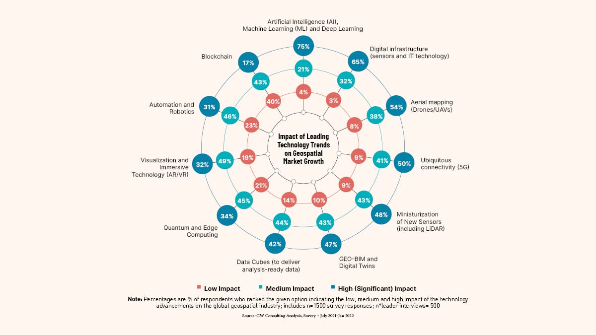
Source: GW Consulting Analysis, Survey – July 2021-Jan 2022
Public policy and market growth
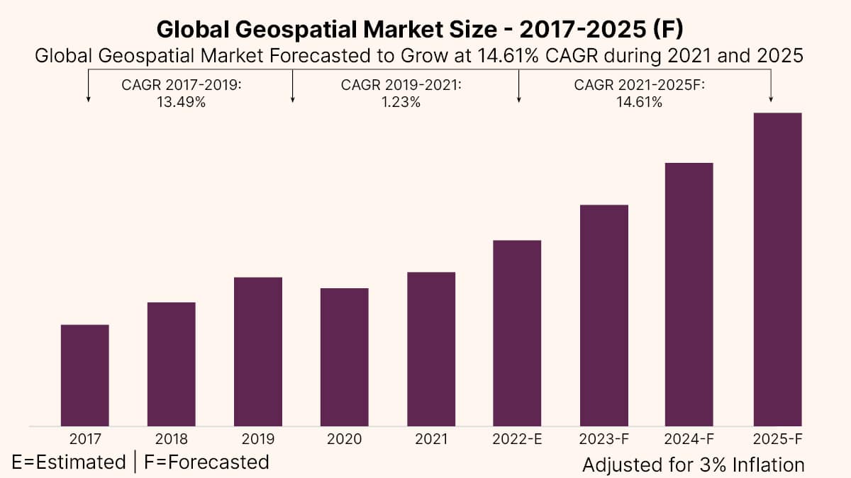
The Global Geospatial Market Size is estimated to be USD 452 billion in 2022 and is forecasted to grow at 14.61 percent CAGR and estimated to be USD 681 billion in year 2025.
However, it is expected to grow at much faster rate of 16.1 percent CAGR post 2025, reaching USD 1.44 trillion by 2030. While the current growth rate is driven by technology innovation, integration of workflows, and augmentation of spatial analytics in business processes, post 2025, this will gain momentum due to public policy reforms and increasing investments in geospatial infrastructure (both public and private) and industry acceleration programs worldwide. The growth impact of public policies and industrial acceleration is estimated to be USD 373 billion between 2025 to 2030 as compared to USD 38 billion in the year 2025, carving out a greater role for national geospatial agencies and governments.
GNSS and Positioning continues to be the largest and growing segment of geospatial market worldwide, accounting for almost 55 percent of the total market share, followed by spatial analytics at 25 percent, and Earth Observation at 17 percent. A decade ago, data was the biggest segment of geospatial market, but technology innovations in the field of software integrated hardware and integration of workflows have augmented analytics as a service, converting the market share of data to spatial enterprise and location-based services.
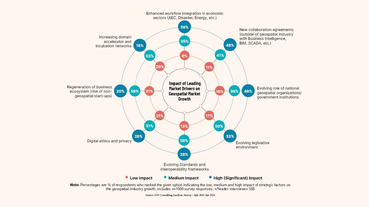
Source: GW Consulting Analysis, Survey – July 2021-Jan 2022
Hot spot for tech leadership
The geospatial market is emerging as a ‘hot spot’ of technology marketplace, wherein several mainstream IT and engineering firms added geospatial portfolios through strategic partnerships and acquisitions. The move is driven with motivation to add geospatial dimension to their existing business portfolios and preparing themselves to stay ahead of the innovation and competitive curves.
Key findings from the report include
The global geospatial market is forecasted to be USD 681 billion in 2025.
The market is estimated to grow at a much faster rate post-2025, making it USD 1.44 trillion by 2030, on the backbone of strategic public policy reforms, industry acceleration strategies, and innovations in the digital twin and metaverse paradigm.
The current growth in the market is driven by technology innovation, integration of workflows, and augmentation of spatial analytics in business processes.
Increasing government investments, strategic public policy reforms, and the evolving role of national geospatial agencies and governments is expected to drive the market growth post-2025.
GNSS and Positioning is forecasted to be the largest and growing geospatial technology segment with approx. 45 percent of the total market share, followed by GIS and Spatial Analytics at approx. 25 percent and earth observation at approx. 17 percent.
The economic impact of geospatial technologies on the global economy is currently estimated to be in the range of USD 2.2 trillion to 5.4 trillion, while it shall expand in the range of USD 5.4 trillion to USD 10.2 trillion in 2025.