Home 2022 December

Monthly Archives: December 2022

Synspective Releases First Image from StriX-1 Satellite

0
Synspective Releases First Image from StriX-1 Satellite
Photo by: Synspective

Synspective Inc., a SAR satellite data and analytics solution provider, announced that it has successfully acquired the image from its third SAR satellite, “StriX-1”.

“StriX-1” was launched by Rocket Lab’s Electron from New Zealand’s Mahia Peninsula launch site on September 16, 2022 (JST) and put into target orbit at an altitude of 561km in a sun-synchronous orbit (SSO).

Since then, it has been operating effectively and has successfully observed several places around the world including Venice and its lagoon in Italy.

Comment from Dr. Motoyuki Arai, Founder/CEO of Synspective Inc.

First of all, I would like to express my sincere gratitude to the Syspective members and everyone who contributed to the successful acquisition of data by our “StriX-1.”

Following the demonstration satellites “StriX-a” and “StriX-ß”, our commercial prototype “StriX-1” successfully entered into orbit and acquired data. We are making great strides toward business expansion as well as the construction of a satellite constellation.

In 2023, we concluded many business partnerships both in Japan and overseas and realized again the growing need for SAR satellite data in various fields.

With the recent success of image acquisition, we will continue to provide high-frequency and high-quality SAR satellite data in line with the needs of society and customers, as well as enhance our solutions using satellite data in the areas of infrastructure development and disaster mitigation.

Comment from Toshihiro Obata, Board Director/General Manager of Satellite System Development Dept., Synspective Inc.

It has been about three months since the successful launch and orbit insertion on September 16. I would like to express my gratitude to all the Synspective development, manufacturing, and operation members, as well as our external partners for their hard work that led to the stable operation of StriX-1 and its image acquisition.

Following the successful acquisition of images by the commercial prototype, whose mission is to expand our business, subsequent satellites are required to stably supply even higher quality data, and we need to focus on building systems and processes aimed at producing a large number of satellites.

We will continue to work together with in-house members and cooperating companies to make steady progress.


Incredible Images Captured by NASA’s Webb Space Telescope in 2022

Incredible Images Captured by NASA’s Webb Space Telescope in 2022

Here are some amazing pictures of space captured by NASA’s JWST:

Cosmic Cliffs

JWST Image
NGC 3324 (Image: NASA via AFP)

This seemingly appearing image of a crested hill filled with flickering stars is actually the birthplace of a star-forming region called NGC 3324 in the Carina Nebula. Captured in infrared light it is the edge of the giant, gaseous cavity within NGC 3324, and the tallest “peaks” in this image are about 7 light-years tall.

Stephan’s Quintet

This image of Stephan’s Quintet, a visual grouping of five galaxies is taken by MIRI (Mid-Infrared Instrument) through its powerful mid-infrared vision which pierces through enshrouded regions to reveal huge shock waves and tidal tails, gas and stars stripped from the outer regions of the galaxies by interactions.

JWST Image
Stephan’s Quintet (Image: NASA via AFP)

Southern Ring Nebula

Informally known as the Southern Ring Nebula, this planetary nebula catalogued as NGC 3132 is approximately 2,500 light-years away and has been sending out rings of gas and dust for thousands of years.
JWST Image
NGC 3132 (Image: NASA via AFP)

Jupiter

Jupiter, the largest planet in our solar system is seen with faint rings which are a million times fainter than the planet itself. Also visible are two tiny moons called Amalthea and Adrastea.

JWST Image
Jupiter (Image: NASA via AFP)

Phantom Galaxy 

This is a composite picture taken from the James Webb Space Telescope and the Hubble Space Telescope shows the heart of a spiral galaxy M74, otherwise known as the Phantom Galaxy. M74 is located 32 million light-years away and consists of about 100 billion stars.

JWST Image
Galaxy M74 (Image: NASA via AFP)

Inner Region Of The Orion Nebula

NASA’s JW Space Telescope’s NIRCam was used to capture the inner region of the Orion Nebula.

JWST Image
Orion Nebula (Image: NASA via AFP)

View of Neptune’s Rings

Neptune named after the Roman Sea God and seven of its fourteen known satellites were captured by the James Webb Space Telescope. Triton, the bright spot of light in the upper left of this image, orbits Neptune in a backward orbit and outshines Neptune because the planet’s atmosphere is darkened by methane absorption wavelengths captured by Webb.

JWST Image
Neptune’s Rings (Image: NASA via AFP)

Fiery Hourglass

This image of the Protostar was captured within the dark cloud L1527 with ejections from the star above and below which appear orange and blue in the infrared view of the Near-Infrared Camera (NIRCam) through JW Space Telescope.

JWST Image
Fiery Hourglass (Image: NASA via AFP)

Farthest Galaxies Ever Seen

NASA’s James Webb Space Telescope Near-Infrared Camera (NIRCam) images show two of the farthest galaxies seen to date in the outer regions of the giant galaxy cluster Abell 2744.

JWST Image
Two Distant Galaxies (Image: NASA via AFP)

Pillars of Creation

This motley of prismatic colors in an ornate highly detailed landscape shows how new stars are formed within dense clouds of gas and dust. The three-dimensional pillars look like imposing hill formations but are far more permeable. These columns are made up of cool interstellar gas and dust.

JWST Image
Pillars of Creation (Image: NASA via AFP)


Dronedek to Introduce Autonomous Drone Delivery in Healthcare

0
Dronedek to Introduce Autonomous Drone Delivery in Healthcare
Dronedek outside office building

Autonomous Delivery by Dronedek drones set to revolutionize how sensitive human samples are transported between medical facilities.

“We’re working with a major health care provider to pilot delivery of blood samples from the hospital to the lab,” said Dronedek Founder and Chief Executive Officer Dan O’Toole. “We’re confident this work will do more than increase efficiencies, it will increase security throughout medical campuses while also bettering the patient experience.”

Currently, hospitals around the world rely on human delivery personnel to deliver sensitive items like blood and tissue samples between hospitals, labs and other medical facilities. This process has inherent delays as medical professionals who obtain samples that need laboratory examination wait for humans to transport the specimens from one facility to another.

Additionally, those deliveries pose security risks as trusted delivery men and women could be impersonated by someone meaning to do harm. Also, humans often, and without meaning to, bring in germs and contamination to the healthcare facilities.

“These items can be easily delivered via drone to a Dronedek security mailbox where they can remain in a climate-controlled, secure environment until an autonomous device comes to retrieve them,” O’Toole explained. “That autonomous device can then deliver the samples to where they need to be, and results can be digitally delivered. Removing the human component takes a lot of risk out of the process.”

Parveen Chand, former COO of a large academic medical center, early advisor to Dronedek and current executive with Ascension, one of the nation’s largest healthcare systems, said he is excited at the prospect of what autonomous delivery can mean to the healthcare industry.

“Coupled with drone delivery, secure and temperature-controlled storage like the patented Dronedek system and autonomous or automated delivery technology, health systems and hospitals now have the ability to reduce expenses along the supply chain and improve efficiency,” he said.

“These technologies can reduce the transmission risk of pathogens and can work around the clock, offering a more reliable delivery method.  Any chance we can get to improve our processes and make them more secure, while enhancing turn-around times and increasing throughput we should explore,” he added.

“The future of logistics in general is autonomous,” he said. “Consumers want faster, cheaper, more accurate delivery, and we’ll certainly give them that, but these applications where lives are on the line, well, it’s just humbling to be a small part in that.”

AI to Strategically Reshape Global Security Landscape

AI to Strategically Reshape Global Security Landscape
Professor V.S. Subrahmanian is a leader in design, analysis and application of AI-based models for real world problems that helps governments and companies in optimal decision-making.

Professor V.S. Subrahmanian is a leader in design, analysis and application of AI-based models for real world problems that helps governments and companies in optimal decision-making.

He is the Walter P. Murphy Professor of Computer Science at the McCormick School of Engineering, Northwestern University and Buffett Faculty Fellow at the Northwestern Roberta Buffett Institute for Global Affairs. He has also coauthored books on terrorist outfits Lashker-e-Toiba and Indian Mujahideen.

In an exclusive interview with Geospatial World, he discusses the evolving global security configuration, emerging cyber challenges, and the utility of AI and satellite imagery in countering multiple threats.

What are your views on the future of the geopolitical situation in view of the ongoing Russia-Ukraine war?

It looks currently as though the Ukraine-Russia conflict will continue at a perhaps lower level of engagement on a daily basis than we saw in the first few months of the war. But we expect it to continue in the coming months. This will have very significant repercussions for the rest of the world, as opposed to just that local geography.

The one major issue geopolitically is oil and gas. We’ve been seeing prices going up, at least in the US and the West. And this winter, Europe is likely to be severely affected by the shortage of gas that they import from Russia for heating purposes.

One of the good things that will come out of this conflict is that it’ll open up more sources of oil and natural gas from around the world. It has forced some European countries to rethink their dependence on Russia for oil and natural gas.

The second is that we are seeing a significant realignment of global partnerships. We are seeing a closer relationship between Russia and China than we had seen in previous years. China needs friends and allies, and having Russia more strongly in its corner will reshape global geopolitics.

As China carries out increasingly aggressive cross-border activities with India, Japan, Taiwan, and other countries such as the Philippines, we can expect no condemnation from Russia, and at the very worst, active support for those kinds of missions, as a sort of quid-pro-quo payback for Chinese help during this Russia- Ukraine conflict.

That’ll have repercussions in how the world, which is already gearing up to combat these kinds of incursions by China, will bring India, Australia, Japan, the United States, New Zealand, and some of the countries in East Asia, such as Singapore, closer together. I expect a coalition of countries to come together more strongly than they’ve done in the past to combat that Chinese aggression.

Most counterterrorism agencies have been proactive in gathering managing intelligence about attacks, but they have not been proactive in taking the battle to the attackers, regardless of whether they’re cyber attackers or whether they are terrorists

You recently released a paper on China’s incursion into India. So how do you see the Sino- Indian border dispute in the long term?

In the long term, both India and China have strong positions on where the border should be. The actual de facto border has not really changed a lot in the last few decades. China has aggressively tried to grab pieces of territory over and over again but, nonetheless, any territorial gains by China have been small, one at a time but these aggregated seizures of small amounts of territory start adding up to something more.

India has taken very strong steps to combat this in the past few years, which include beefing up the surveillance and troops along the border, building better roads, air bases, and tunnels along the border. All these efforts are very significant defenses and deterrents to China.

ALSO READ: Top Five Mobility Trends to See in 2023

This needs to be beefed up even more. The development and use of autonomous vehicles and weapons, which are capable of navigating the harsh terrain along the India-China border and the harsh weather, is critical.

When I say autonomous vehicles, I really mean drones and land vehicles, both for surveillance and offensive purposes, which is the way forward in terms of mitigating the risk to humans and human life. Some kind of ground vehicles and aerial vehicles that can Chinese aggression in these harsh conditions are going to be needed.

Tell us about the newly launched Northwestern Security and AI Lab (NSAIL), and the technologies that were used. How can policymakers make the right use of cyber forensics to help in preventing terrorist attacks?

The Northwestern Security and AI Lab is a new lab which is jointly housed between the McCormick School of Engineering at Northwestern (the technology development arm of the lab) and the Buffett Institute for Global Affairs.

We are focused on using AI to reshape the landscape strategically and tactically. Most counterterrorism agencies have been proactive in gathering managing intelligence about attacks, but they have not been proactive in taking the battle to the attackers, regardless of whether they’re cyber attackers or whether they are terrorists.

Part of what we are doing in the NSAIL is to imagine what the next wave of attacks will be, as advanced technology comes out. This is all about being ahead of the curve, instead of constantly being behind the curve.

Digital Terrain Elevation Data (DTED) maps tell us about the elevation of every part of the world. One can buy them off the internet at pretty reasonable prices and these maps tell you with granularity how the terrain changes in terms of elevation

And of course, once we know how we expect the attackers to attack us, we can come up with better defenses. For example, right now, we are working on a research paper and a demonstration, which will come out in February 2023 titled “Drone Urban Cyber Defense Testbed (DUCK)”.

DUCK looks at drone attacks with swarms of on cities and urban areas, because drones are pretty cheap today. We have come up with techniques to simulate how adversaries might use swarms of drones to target cities even before they do so. We will come up with multiple defensive methods to guard against that.

We are also working on a system called Tread, which is intended to combat terrorist groups. As an example, in my book on Lashkar-e-Taiba (2012), one of the big findings was that as long as Lashkar-e-Taiba is squabbling internally, fighting amongst themselves, the probability of terrorist attacks goes down dramatically, almost to zero.

So, as a counterterrorism strategy, inducing conflict between leaders of Lashkar-e-Taiba is very desirable. So we’ve been developing deepfake technology with the use of AI, to put words in the mouths of these terrorists, intended to sow such conflict within the group.

We’re looking at this nexus of AI and how terrorists might use it, and how we can get ahead of them.

What roles do remote sensors play in predicting terror activities?

Terrain and weather play a huge role in terror attacks. During terrorist attacks, when they look at target selection, the first question is, “What is the value of the target?” The value could be along many different dimensions:

  • Will a lot of people be killed?
  • Or will certain groups of people be killed, such as in the attack on the Indian parliament in 2001.

The second is, “Can it be done?” Terrorists might wish to attack certain targets, but it may or may not be doable. So what is the probability that they can succeed in an attack?

Then the third is backlash.

ALSO READ: Significance of Cybersecurity Certification for Drone Systems

For the second question, “Is this target attackable,” remote sensing and geospatial information play a huge role. If you look at a major target, there are multiple layers of security around it, which are situated in space and time. For example, there’s a checkpoint here, or a convoy there and, after an hour, it may be somewhere else. Understanding the nature of the defenses of a target is completely embedded in geospatial and temporal domains.

The probability of an attack on a location depends upon several things like, “What is the terrain like?” for example, to traverse one kilometer, a soldier might have to go through a steep downhill or climb uphill in forbidding terrain, hence, understanding the nature of the terrain at a specific point in time is critical.

There are things called Digital Terrain Elevation Data (DTED) maps, which tell us about the elevation of every part of the world. One can buy them off the internet at pretty reasonable prices and these maps tell you at fairly fine grain granularity how the terrain changes in terms of elevation.

We have collected maps from NASA satellites which are also publicly available that tell us about vegetation, drainage and the presence of water, etc. The channels of water change the traffic-ability of that entire geography, because the parts that were walkable or can be crossed with the help of a vehicle this year may not be doable next year. You need to understand static assets, such as where are the roads, the military encampments, the border posts, or the airfields.

At the same time, you also need to understand, how people are moving across the terrain. This is where satellite imagery is extremely valuable. The airfields are not changing location, they only come up once in a while, but people are changing their location every day. Their patrolling pattern, checkpoints and deployments are changing every day.

For example, it is possible, using AI, to use probes (that is, autonomous vehicles) to review China’s defenses. We can send some autonomous vehicles across to see what the Chinese do, and whether they are paying attention or not.

There are both passive methods and active methods where the satellite imagery data is collected, analyzed, and all of them live in geography.


ASENSING to Expand Positioning Solutions to Global Partners

0
ASENSING to Expand Positioning Solutions to Global Partners

ASENSING, a Chinese positioning solutions company for autonomous vehicles, is ready to provide its navigation systems globally. The company already has more than 500,000 autonomous vehicles integrated with its navigation systems and is discussing global product expansion with major Western brands.

The company is the first in series production of an automotive solution that combines IMU and GNSS, enabling it to develop an algorithm to maintain navigation accuracy at various temperatures. Its positioning solutions are designed for autonomous driving at L2 level and above and meet functional safety requirements.

The company has three global branches, in the United States, Germany, and Japan with plans to launch more smart plants in east and south China to accommodate for an influx of orders. ASENSING will exhibit its mass-produced positioning solutions at the Consumer Technology Association’s Consumer Electronics Show 2023 in Las Vegas, Nevada.

U-Blox Bans the Use of its GNSS Modules in War

0
U-Blox Bans the Use of its GNSS Modules in War

U-blox banned the use of its GNSS modules in military UAVs in the war between Russia and Ukraine. The company had become aware that its GNSS modules were being used in certain Russian reconnaissance UAVs and stated that this use was against company policy.

The company obtained media reports that Russia had stocked up on components in anticipation of war, then integrated products from the company in UAVs it manufactured after attacking Ukraine.

After Russia began its invasion of Ukraine, the company halted all sales to Russia, Russian territories, and Russian-occupied areas, as it intends its GNSS modules and other products to be used only commercially.

The company policy bans the use of its products in weapons, including systems for target identification. It is investigating the infringement of its policy and plans to take legal action if it has been violated. The company also condemns the invasion of Ukraine by Russian forces.

Key Drone Trends for 2023

Key Drone Trends for 2023

Drones have been rising to the mainstream as their popularity has increased. From crucial rescue operations to last-mile logistics, drones have seen more and more innovation that has increased the pool of their users. As the years move on, drone technology only seems to get stronger and better, and its popularity is evidently on its way to growing exponentially as the use cases for drones seem endless.

Here are five key drone trends for 2023:

Aerial LiDAR

In recent years, LiDAR technology has grown multifold. The term LiDAR comes from Light Detection and Ranging and is widely used to collect data on different surfaces and construct a 3D model. Now, as LiDAR sensors become widely available, more use cases are coming out.

Moreover, drones are becoming more mainstream as well, which is signaling a convergence of drone technology with LiDAR. Earlier, LiDAR was either used by helicopters, planes, or satellites to map the ground below. However, drone LiDAR is slowly revolutionizing the industry. A wider approach and use of drone LiDAR will be seen in 2023.

Drones-as-a-Service

A possibility on the cards for a while, Drones coming in with in-built technology to provide services for particular problems. This means the drones will come in productized state and will be readymade to fulfill the demands set forth. This will reduce time to value ratio drastically, streamline the issue, and tackle it much more efficiently.

This drone innovation will help every vertical and offering that drone technology has to offer. From Digital Twin creation to Asset Inspection, drones-as-a-service will see huge growth.

Algorithm-Driven Autonomous Drones

Autonomous vehicles have been creating a buzz lately in the world. With autonomous technology catapulting into the mainstream, it is a matter of time before it hits the drone sector. Both Artificial Intelligence (AI) and Machine Learning (ML) have a big role to play in making drones autonomous, and subsequently, 2023 will finally see various types of drones flying without manual intervention.

This will majorly help the logistics business, as it will remove manual errors, and work faster, and in a systematic manner. Last-mile logistics will be revolutionized with drones delivering packages in minutes rather than hours.

Monitoring renewable energy sources

An increasing concern globally, climate change has been shaping future policies greatly. Now, as the focus on renewable energy increases, many companies will look to incorporate these energy sources. However, finding a suitable area for an energy plan and then mapping it out is a herculean task, to say the least.

Drones will help massively in surveying and mapping large areas of fields to chalk out the area suitable for renewable energy sources such as solar panels or wind turbines. Moreover, thermographic imaging capabilities in drones will help monitor such areas 24/7.

Drones in Digital-twins

A scaled replica or a virtual model of a physical object with known dimensions, color, temperature, and thickness of the wall is known as Digital-Twin. Extremely crucial for the infrastructure sector, Digital twins are widely used before constructing large-scale properties.

Drones can transform digital twin technology by capturing detailed overviews of any given physical object. They can deliver thorough accuracy with optimum energy. Moreover, they can capture 360 degrees of the physical asset and make the collected data worthwhile.

ElectraMeccanica Announces Cost Reduction Initiatives

0
ElectraMeccanica Announces Cost Reduction Initiatives
ElectraMeccanica Vehicles Corp. a designer and manufacturer of electric vehicles revolutionizing the urban driving experience, today announced cost-reduction initiatives to further streamline the business in order to better consolidate onshore manufacturing capabilities and operations at its newly-commissioned Mesa, Arizona headquarters. These steps will accelerate the Company’s path to profitability, by imposing a new level of fiscal discipline that preserves the ability to commercialize and scale operations while also eliminating excess costs.

The New CEO/interim COO Susan Docherty has led an ongoing, top-to-bottom review of the Company’s existing operations footprint; product portfolio; product development; investment; capital allocation; and employee skills, distribution and efficiency. While this review is ongoing, the Company currently has elected to resize its workforce, lowering its headcount by 98 positions. This reduces the employee base outside Arizona by 57% and improves operating costs by approximately $10 million annually. The Company notes that its balance sheet and market demand for the SOLO remain healthy.
Separately, the Company announced it had appointed Ms. Docherty to its Board of Directors effective December 20, 2022. Additionally, as another outcome of its top-to-bottom review of the business, ElectraMeccanica is postponing its Investor Day until June 14, 2023, in order to focus exclusively on near term execution and so that it can provide the most comprehensive possible review of its business and future plans to shareholders.

2022 A Year in Review through Satellite Imageries

0
2022 A Year in Review through Satellite Imageries

2022 has seen various natural calamities, from floods that plagued Pakistan, wildfires that spread across Europe to Russia-Ukraine war effect that had its impact around the world and extreme climate change to advances in space science. In this video you’ll see these events through satellite imageries.

Adding the Geo Dimension

Adding the Geo Dimension

The word ‘intelligence’ immediately conjures an image of dark-suited men in dark sunglasses with a tightly grasped briefcase. Geospatial Intelligence adds additional mystery in the form of secret imagery of missile sites.

Indeed the world of military intelligence and peaceful uses of satellite imagery were set so far apart that never the twain would meet. Advances in technology and resource management have changed that. Now the two not only meet but overlap.

Satellite imagery resolution has improved to a point where commercially available imagery can produce maps at the level of detail that is needed for city ward maps and rural cadastral maps, not to mention the detection and location of defence and offense assets.

Further, the term intelligence now encompasses both military and civil requirements. The need to be able to observe and track military activities also extends to the need for monitoring activities that are inimical to human life and nature.

Both need fast information transfer from acquisition to delivery via analytics. The need to track a band of terrorists is no less critical than to predict the path of a cyclone.

From detection to interdiction, and to prevention needs fast analytics. Data Science, AI, ML and Deep Learning are the tools. Some of these can work on the Edge and provide near real-time analytics.

An interesting demonstration of fast computing using satellite data on a Web Services platform on the Cloud has also established another possibility of fast information turnaround.

An old technology, ELINT has been given a new lease of life through RF sensors that can track dark vessels – ships that have switched off their AIS. This has been used to track ships involving clandestine operations which could include illegal breaching of sanctions as well as illegal fishing in protected waters.

Humanitarian crisis management in times of war and in times of natural or man-made disasters is another area where geo-intelligence plays an important role.

The most recent example is the ongoing Ukraine-Russia conflict where populations have been subjected to denial of food, health facilities and electric power. Locating such clusters and reaching them aids tests the capabilities of geospatial technologies.

Disasters due to violent weather events brought on by Climate Change have lent an impetus to the development of world weather Digital Twins which can then predict possible threats, particularly to vulnerable areas like low-lying islands and launch protection measures.

Geo-intelligence is the need of the times which have become very complex in terms of conflict between nations, between humans, and between humans and nature. Meaningful information can lead to thoughtful actions, which in turn can help humankind be at peace with each other and with nature.

Top Five Mobility Trends to See in 2023

Top Five Mobility Trends to See in 2023

People are evolving, so are technologies to accommodate their needs and comfort. The technologies that existed in the pre-pandemic era have been replaced with more modern ones equipped with modern amenities. Cities are getting smarter as well as sustainable with the adoption of technologies.

Now that efforts are being made to keep carbon emissions on check, and sustainable ways are being explored to keep the environment clean while meeting all the connectivity requirements, mobility trends are falling in place.

Economic and environmental factors such as rising fuel prices and economies shifting to greener and sustainable transportation to decrease the carbon footprint drive the micromobility market demand worldwide.

As the market grows, associated sub segments such as electric two wheelers fleet businesses and battery manufacturing, swapping, and charging infrastructure register concurrent growth.

Watch the video here:

Here are the top mobility trends that are going to change the way people travel, in 2023:

Shared mobility

Mobility trends

McKinsey’s report forecasts that micromobility has the potential to reach a consumer-spending of $300 billion to $500 billion globally by 2030, which comprises of both shared and private micromobility.

The pandemic has slowed down the use of public transport drastically, however the sector is recovering and people are moving towards shared mobility option especially the two wheelers. e-kick scooters to e-bikes are becoming popular for small distances and last mile delivery purposes.

Moreover, organizations are also investing in developing infrastructure for their employees to share vehicles en-route to office, since the workforce is coming back to office.

Autonomous driving

The autonomous vehicle model is being adopted by many top auto manufacturers and suppliers to prevent and reduce road accidents, and to eliminate human errors. With the new and fast ways of connectivity entering the market like 5G, big data, human machine interface (HMI), integration of AV has become one of the most sought after technology.

As IDTechex highlights that autonomous trucks are on the cusp of real-world use, and next-generation sensor technologies are being deployed on vehicles.

They have also forecasted that the concept of robo shuttle-powered future will see small, shared vehicles will be able to operate more flexible than a bus.

Flying Taxis

Air taxis are going to revolutionize the way people commute. How? They are going to ease the transport infrastructure issues of growing cities and simplify congestions.

Developers believe that with safety certification and clearance in place, air taxis will provide pleasant, fast and efficiency in terms of travelling. They will also make emergency responders work easy and quick.

Reports suggest that the investment in the advanced aerial mobility sector has almost tripled in 2021-22 and according to Morgan Stanley, the global air taxi market is expected to reach $3.27trillion by 2050.

Electric vehicles

Mobility trends

2021 saw a 35% increase in the number of electric vehicles (EVs) sold than those sold in the last five years combined and by November 2022, UK registered sale of more than 30,000 new EVs.

People are inclining more towards the eco-friendly options and so are the manufacturers to cut down their carbon emissions, to if not stop but reduce the effects of climate change. Automobile giants have recently started investing heavily in the electric models of their cars. In many countries the government is working on modifying the infrastructure to accommodate the future electric vehicles.

Reports suggest that by 2025, 20% of the total cars in the globe will be electrically run and by 2030, all the petrol run cars will be banned from use in order to reach net zero emissions.

Turbocharging

Mobility trends

Since there is too much pressure on the fuel consumption and reduce carbon emissions, automobile manufacturers are looking for alternative methods to compensate the fuel demands with something better and efficient. This is where turbochargers have made their way to give new life to diesel engines and other gasoline engines.

One of the major advantages of turbocharging making it to the list of top mobility trends that we will see in 2023 is because it is able to faster the speed, make the engines perform better without damaging it.

According to Allied Market Research, the global turbocharger market is expected to garner $24.23 billion by 2027, growing at a CAGR of 5.3% from 2020 to 2027. The need for engine downsizing to reduce vehicle weight, government regulations, and improved engine performance and fuel efficiency drive the demand for turbochargers.

GenH2 Launches Mobile Liquid Hydrogen System

0
GenH2 Launches Mobile Liquid Hydrogen System
GenH2 is the leading Hydrogen Infrastructure Company with decades of experience researching, engineering, and producing technology solutions necessary for the Hydrogen Economy. Leveraging years of collaboration with the top hydrogen experts, the company focuses on the commercialization of CO2 free Hydrogen generation, liquid hydrogen storage, and dispensing.

GenH2, announced the launch of its ground-breaking LS20 Mobile Liquid Hydrogen System, an end-to-end liquefication and storage system. The innovative, mobile liquefaction unit offers a space-optimized, fully integrated liquid hydrogen solution to be used in a range of applications from transportation to energy backup to accelerating the use of liquid hydrogen through pilot projects and testing. It will also be utilized as a lab setting for testing material, insulation, thermodynamic properties, and use cases for their applications.

With a mission to provide light-scale infrastructure solutions for liquid hydrogen, GenH2 designed the LS20 with the capability of producing small amounts of liquid hydrogen in order to provide access to more hydrogen researchers and hydrogen industry players. The LS20 can produce between two and 20kg of liquid hydrogen per day, to provide liquid hydrogen at-the-ready, when and where it is needed. Twenty kg of liquid hydrogen contains nearly 2400 Megajoules of energy and can be readily stored and used within GenH2’s ultralight utility tank systems.

“The development of the LS20 has been a culmination of decades of experience and engineering within and in conjunction with NASA.Providing researchers and developers of hydrogen infrastructure with a modular, efficient way of getting their hands on liquid hydrogen is a vital requirement to advance the hydrogen economy,”said Jong Baik, Chief Technology Officer of GenH2.

The smallest liquid hydrogen mobile unit currently commercially available, the LS20 is self-sustaining and can run independently with a portable generator or plug into a building’s power source. This makes the LS20 ideal for dispensing fuel to multi-purpose drones and providing an emergency power supply to first responders. Additionally, the LS20 units are manufacturing ready to keep up with the increasing demand for hydrogen and enable faster infrastructure build-out and adoption. According to Baik, with its flexibility, compact size, and speed-to-market capabilities, the LS20 is a game-changer for a rapidly growing hydrogen industry.

The LS20 is designed for those areas where relatively compact systems are necessary to enable hydrogen viability. As a complete system, the LS20 can liquefy, store, and dispense liquid hydrogen from any gaseous hydrogen source, such as a storage tank or an electrolyzer. This compact, flexible system offers the user the ability to provide liquid hydrogen when and where it is needed. The key features of LS20 technology are:

  • Convenient and safe liquid hydrogen production on demand between two and 20 kg per day
  • D.O.T. approved 400 Liter capacity liquid hydrogen storage tank with zero-boil-off storage feature
  • Fully automated liquid hydrogen production/storage level control and monitoring system
  • Zero-loss, liquid-to-liquid transfer system with hydrogen gas recovery bag
  • Detachable liquid hydrogen storage tank for separate liquid hydrogen transport
  • Innovative quick-connect vacuum jacketed receptacles
  • Ultra-light liquid hydrogen tanks for hydrogen mobilities such as cars, drones, UAVs, trucks, etc.
  • Hydrogen detection sensor, Oxygen monitoring, IR hydrogen flame detectors
  • Multiple pressure relief devices and advanced emergency venting system

The LS20 also serves as a foundation for higher capacity GenH2 systems including the 100Kg LH2 per day and 1000Kg LH2 per day solutions. Once deployed, these solutions will be an innovative addition to the options for advanced clean energy. The LS20 demonstrates GenH2’s continuing support for the expansion of the hydrogen economy. The company is working closely with the Department of Energy, NASA, various universities, and energy companies around the globe.

Hexagon partners with ZF Group on autonomous driving systems

0
Hexagon partners with ZF Group on autonomous driving systems

Hexagon announced a partnership to integrate its software positioning engine and correction services with ZF Group’s ProConnect connectivity platform. This will enable vehicle communication in advanced driver assistance systems (ADAS) and autonomous driving systems.

This integration is critical to providing the necessary functional safety, lane-level positioning accuracy and automotive safety integrity level (ASIL) rating that ZF’s automotive telematics platform requires. Hexagon’s TerraStar-X precise point positioning correction service will greatly improve the accuracy and reliability of ADAS and autonomous driving systems.

Hexagons’ dual frequency and multi-constellation GNSS receivers are tightly coupled with inertial capabilities that withstand vehicle dynamics in all driving conditions.

Both companies are focused on the next generation of mobility, including electric vehicles and autonomous systems, and this partnership helps advance safety and automation in the automotive and transportation industry. Hexagon and ZF plan to demonstrate their ADAS at the Consumer Electronics Show in Las Vegas in January 2023.

Linux Foundation’s AgStack Project will build dataset of field boundaries

0
Linux Foundation’s AgStack Project will build dataset of field boundaries

The Linux Foundation announced its AgStack Project, which will host an open-source code base, along with a fully automated, continuous computation engine that will maintain a global dataset of boundaries for agricultural fields. The AgStack Asset Registry dataset will aid food traceability, carbon tracking, crop production, and other field-level analytics.

This ‘registry’ is designed to continuously update using data from satellites and real field registrations that contain boundary information, which will train machine learning models to ascertain more boundaries, among other capabilities.

Agricultural datasets are rarely public information. By using computer science and artificial intelligence (AI), users can create global field boundaries as a digital open source for public use, which can help farmers, agricultural companies, and the public manage crop production, study management practices, assess levels of productivity, monitor the spread of pests and diseases and more.

The AgStack project seeks to enable all types of agricultural data and services by combining computing and AI expertise with a global network of partners in an open-source software system. All code is being contributed under an open-source license and will be governed by the AgStack community, within the Linux Foundation.

Charting the Trajectory of India’s Promising Geospatial Sector

Charting the Trajectory of India’s Promising Geospatial Sector

The increasing ubiquity of spatial applications and solutions, and their intertwined nature with EO and space, offer enormous prospects for sustainable growth, however, there are certain challenges that need to be resolved.

The Ministry of Science and Technology, in February 2021 deregulated the geospatial sector to grant open access to the geospatial data and services, including maps, for all Indian entities, with the exception of sensitive defence or security-related data.

Due to this watershed move, the private sector and innovators no longer require prior approvals before generating or updating digital geospatial data and maps within the territory of India. There is also no requirement for security clearance, license, or any other restrictions.

Geospatial technologies mainly consist of Remote Sensing GIS (Geographic Information System), GNSS (Global Navigation Satellite System) and Survey 3D modelling. The biggest consumer of geospatial data in India is the Survey of India (SoI), Indian Space Research Organisation (ISRO), Remote Sensing Application Centres (RSACs), the National Informatics Centre (NIC) and all ministries and departments.

Geo-Intelligence is another massive use category of spatial data collection. Increasing use of horizontal technologies like IoT, big data analytics, AI, mobility, and cyber not only enables full potential utilization of geo-intelligence assets but also opens up new use cases in military intelligence.

The Geospatial market as of 2021 was Rs 38972 Cr. As per the Geospatial “Artha” Report 2021, India’s geospatial economy has been projected to cross Rs 63,000 crore by 2025, growing at a rate of 12.8%, providing employment to more than 10 lakh people mainly through geospatial start-ups. There are also reports that put the projected net worth growth at Rs 1 lakh crore by the year 2029 CAGR. As mentioned by Union minister of state for Science and Technology Shri Jitendra Singh, India’s robust ecosystem is led by technology start-ups. There are around 250 geospatial start-ups in India and most would be moving towards high-tech ground-level surveillance.

With more investments and government budgetary support, there will be a spurt in geospatial innovations leading to more accuracy of data which would eventually bring down the cost of innovation, a huge win-win for tech start-ups. The private sector is set to take precedence over international tech giants sooner than we know. The country will extend this infrastructure access to benefit South Asian neighbouring states as well.

To provide a much-needed impetus, the Indian government has provisioned for a Geospatial Incubator and the Bhunidhi portal, both developed by Hyderabad’s National Remote Sensing Centre (NRSC), and a solar calculator developed by ISRO’s Space Application Centre in Ahmedabad and National Toponymy Database.

Recently, several bodies such as Survey of India, Geological Survey of India, National Atlas and Thematic Mapping Organization (NATMO), ISRO, and the National Informatics Centre implemented several GIS-based pilot projects across a range of domains such as waste resource management, agriculture, telecommunications, disaster and climate management, environmental studies, architecture, forestry, urban planning, etc. to demonstrate the applications of geospatial.

There are plans by the government to leverage spatial data in projects such as SVAMITVA, Gati-Shakti, Smart Cities and Disaster Management. Let’s look at some of these ambitious government projects where geospatial technology would disrupt the market.

SVAMITVA (Survey of Villages and Mapping with Improvised Technology in Village Areas)

Establishment of Continuous Operating Reference System (CORS) network with large-scale mapping using Drones of Rural inhabited (Abadi) locations by Survey of India using drone Survey. The objective of the program is the creation of accurate land records for rural planning, and to bring financial stability to the citizens in rural India by enabling them to use their property as a financial asset.

In the creation of survey infrastructure, GIS maps would be leveraged to support the preparation of a better-quality Gram Panchayat Development Plan (GPDP).

The survey will be done across the country in a phased manner over the period 2020 -2025.

The Ministry of Panchayati Raj (MoPR) is the Nodal Ministry for implementing the SVAMITVA (Survey of Villages and Mapping with Improvised Technology in Village Areas) Scheme. Survey of India shall work as the technology partner for implementation.

Massive role of Spatial Data in the Gati Shakti Project

The most ambitious Gati Shakti project entails the geospatial mapping of everything where different layers of maps would be integrated, leading to unified and coherent planning with better time-and-cost optimization.

The introduction of GIS in governance would ease of doing business and reduce compliance burden. Moreover, advances in mapping technology will become the base for innovation in other projects like Smart Cities and Disaster Management Policy.

Disaster Management

During any emergency, the role of a reliable Decision Support System is very crucial for effective response and recovery. With better connectivity networks, damage costs from natural disasters can be potentially reduced by 39% therefore Information and Communication Technologies in form of Internet, GIS, Remote Sensing, Satellite communication, etc. are indispensable in achieving that.

The country is already proving satellite-based near real-time information support to Central Ministries / Departments and State Ministries / Departments, before and after major natural disasters.

‘Digital North East 2022’ was announced to leverage GIS, RS and space technologies in fulfilling the ICT (Information and Communication Technology) needs to act as a Decision Support System [DSS] in the North Eastern Region [NER] which has been a digitally deprived region in India.

ISRO is actively involved with various other countries in this, through international frameworks, such as International Charter ‘Space & Major Disasters’, Sentinel Asia, UNESCAP, and so on. United Nations Development Programme (UNDP) has joined hands with India in implementing the GoI-UNDP Disaster Risk Management (DRM) programme in 169 most vulnerable Districts of 17 States in India.

Relevant information is disseminated in the interactive geospatial domain through various geoportals like Bhuvan, National Database for Emergency Management and the Meteorological & Oceanographic Satellite Data Archival Centre [MOSDAC] for the administrators to better understand the impact and for improved decision support.

Way Forward

There is a massive potential for India’s geospatial sector, however, a few hurdles remain viz., lack of awareness among potential users including the government, and inadequately skilled manpower. The unavailability of high-resolution data is also a huge constraint. Additionally, there is a lack of clarity on data sharing and collaboration which prevents co-creation and asset maximization.

The scope of deospatial tools is humongous, however, due to these challenges the use cases aren’t foolproof. India lacks skilled manpower and core professionals who understand geospatial end-to-end.

Despite being the most rational technology for managing disasters, spatial tech is hindered by the high cost of adoption. In next-gen mapping and GNSS in India, global tech giants are still dominating the space although homegrown companies are trying to make inroads.

India needs to raise awareness, increase access to government data, provide training for professionals, and plunge investment into the sector.

We need to develop our own resources for mapping and GNSS to realise the goal of Atmanirbhar Bharat and the vision of a $5 trillion economy. In the case of indigenous GNSS service in India, the Government needs to invest in developing and mandating the adoption of standards. There’s a need for uniform standards, protocols and norms across the country.

The role of Artificial Intelligence [AI] is vital to all disaster management phases, leading to a faster, more concise, and equipped response. Technologists are rapidly pushing AI’s ability to have highly accurate forecasts, optimizing aid deployment and real-time monitoring and staying prepared for a more resilient tomorrow and India needs to catch up with the required pace in this arena.

Data accuracy is a critical challenge and to achieve this a network of ground control points (GCP) is needed to accurately map the imagery with ground coordinates and its relative position on Earth. There is also a need to create a centralized database to capture and store all data results. Standardization of the data entry process, and smooth availability of high-resolution data remains essential. Therefore, the issue of availability of suitable equipment to capture data must also be addressed.

Awareness needs to be created among potential users in government and private across various sectors. Inter-ministerial collaboration needs to be formed.

Localisation of Data can address national security issues. There is a need to develop a geospatial data cloud locally and facilitate a solution-as-a-service. National organizations like the SOI should be entrusted with the responsibility of regulation and projects related to the nation’s security and scientific significance.

Academic backing is also critical. India should start a bachelor’s programme in geospatial also in the Indian Institutes of Technology (IITs) and the National Institutes of Technology (NITs). Besides these, there should be a dedicated geospatial university.

We need to promote research and development efforts for technology indigenization.

Advancing & Augmenting USD 1.4 Trillion Geospatial Market by 2030

Advancing & Augmenting USD 1.4 Trillion Geospatial Market by 2030

Advancing & Augmenting USD 1.4 Trillion Geospatial Market by 2030

Strategic public policy reforms, industry acceleration strategies, and innovations in the digital twin and metaverse paradigm to drive geospatial market growth post 2025.
GeoBuiz 22: Global Geospatial Industry Outlook Report

Geospatial industry is the next ‘Big Opportunity’ for technology companies both as an ‘advancing market in itself’ and ‘augmenting business processes’ of mainstream IT, Engineering and Autonomous industries. It would continue to provide accurate and rich foundation to data infrastructure and increasingly add the third dimension to ‘everything we do’. This will result in geospatial getting by default embedded in digital twin and metaverse, which will further impact how humans interact with digital and physical world in near real time. The technology leadership must look at geospatial market holistically as it is evolving to be a ‘process of insight’ as an outcome, while moving up the value chain in the field of reality capture in terms of coverage, context, themes, accuracy, and currency.

Data insight and knowledge economy

Data insight is at driving wheel of knowledge economy, penetrating and integrating across workflows and processes of every industry. And as every business gets more and more driven by insights, data would serve as oil to knowledge economy and shared economy business models, aimed at deriving greater efficiency, productivity, transparency, and compliance.

Geospatial infrastructure, which comprises of foundation data, positioning network, platform, standards, knowledge services, and policies, provides overarching framework and serves as the interface between government and commercial enterprises to work towards extending geospatial value chain and scalability of applications supporting development, governance, business, and security. Recognizing the growing value of geospatial knowledge infrastructure, there have been several initiatives towards public policy and industrial development worldwide, and the same has been laying the path for amplified growth by the year 2030 and beyond.

Source: GW Consulting
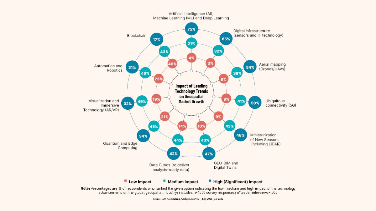
Source: GW Consulting Analysis, Survey – July 2021-Jan 2022

Public policy and market growth

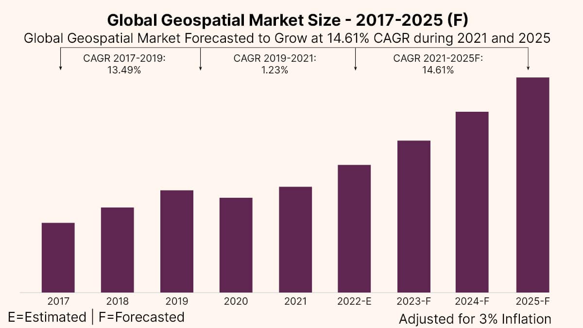
The Global Geospatial Market Size is estimated to be USD 452 billion in 2022 and is forecasted to grow at 14.61 percent CAGR and estimated to be USD 681 billion in year 2025.

However, it is expected to grow at much faster rate of 16.1 percent CAGR post 2025, reaching USD 1.44 trillion by 2030. While the current growth rate is driven by technology innovation, integration of workflows, and augmentation of spatial analytics in business processes, post 2025, this will gain momentum due to public policy reforms and increasing investments in geospatial infrastructure (both public and private) and industry acceleration programs worldwide. The growth impact of public policies and industrial acceleration is estimated to be USD 373 billion between 2025 to 2030 as compared to USD 38 billion in the year 2025, carving out a greater role for national geospatial agencies and governments.

GNSS and Positioning continues to be the largest and growing segment of geospatial market worldwide, accounting for almost 55 percent of the total market share, followed by spatial analytics at 25 percent, and Earth Observation at 17 percent. A decade ago, data was the biggest segment of geospatial market, but technology innovations in the field of software integrated hardware and integration of workflows have augmented analytics as a service, converting the market share of data to spatial enterprise and location-based services.

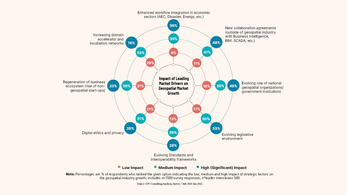
Source: GW Consulting Analysis, Survey – July 2021-Jan 2022

Hot spot for tech leadership

The geospatial market is emerging as a ‘hot spot’ of technology marketplace, wherein several mainstream IT and engineering firms added geospatial portfolios through strategic partnerships and acquisitions. The move is driven with motivation to add geospatial dimension to their existing business portfolios and preparing themselves to stay ahead of the innovation and competitive curves.

Key findings from the report include

  • The global geospatial market is forecasted to be USD 681 billion in 2025.
  • The market is estimated to grow at a much faster rate post-2025, making it USD 1.44 trillion by 2030, on the backbone of strategic public policy reforms, industry acceleration strategies, and innovations in the digital twin and metaverse paradigm.
  • The current growth in the market is driven by technology innovation, integration of workflows, and augmentation of spatial analytics in business processes.
  • Increasing government investments, strategic public policy reforms, and the evolving role of national geospatial agencies and governments is expected to drive the market growth post-2025.
  • GNSS and Positioning is forecasted to be the largest and growing geospatial technology segment with approx. 45 percent of the total market share, followed by GIS and Spatial Analytics at approx. 25 percent and earth observation at approx. 17 percent.
  • The economic impact of geospatial technologies on the global economy is currently estimated to be in the range of USD 2.2 trillion to 5.4 trillion, while it shall expand in the range of USD 5.4 trillion to USD 10.2 trillion in 2025.

Stellantis Completes Acquisition of aiMotive

0
Stellantis Completes Acquisition of aiMotive

Stellantis N.V. today announced that it has finalized the acquisition of aiMotive, a developer of advanced artificial intelligence and autonomous driving software.

“The acquisition of aiMotive will accelerate our journey to become a sustainable mobility tech company and deliver our Dare Forward 2030 goals,” said Yves Bonnefont, Stellantis Chief Software Officer.

“Thanks to aiMotive’s world-class expertise, we will enhance our artificial intelligence and autonomous driving core technology, expand our global talent pool, and foster the mid-term development of our all-new STLA AutoDrive platform,” he added.

“In 2015, I founded a company that would develop technologies to shape the future of mobility for everyone,” said László Kishonti, founder and CEO of aiMotive. “I’m delighted that seven years later we can contribute to Stellantis’ ambition and work together to make millions of customers’ cars better, safer and more intelligent.”

aiMotive will operate as a subsidiary of Stellantis, maintaining its operational independence. Founder László Kishonti will remain as CEO. It will also continue operating on the market with aiSim, aiData and aiWare, delivering its technology solutions in those key areas to third-party customers.

Stellantis will establish a Board of Directors to oversee aiMotive while preserving its autonomy and startup mindset of rapid innovation.

Vianova builds Location Data Platform for shared mobility companies and cities

0
Vianova builds Location Data Platform for shared mobility companies and cities

Vianova, a French startup is building a data platform for shared mobility companies as well as local governments. The company acts as both a data repository and a data visualization dashboard.

It has raised a $6.4 million (€6 million) Series A funding round led by Baloise VC with XAnge as well as existing investors RATP Capital Innovation and Ponooc also participating.

The mobility fleets all have some form of connectivity with a GPS chip and a cellular modem. Companies and local governments can use data to make those services more efficient and safer for people using them and everyone else living in these cities.

Vianova tracks 1 million connected vehicles on its platform at the moment. Some companies use the platform to manage their fleet and make sure the vehicles are in the right spots at the right time.

Policymakers and data scientists can also leverage this platform to discover some trends. It can be used to improve infrastructure, create slow-speed zones or parking areas through geofencing and more.

All of this can be done through a SimCity-like dashboard with map overlays and real-time data. Vianova can be used as a real-time dashboard and as an analytics tool to generate historical reports and see how well a company is performing.

One can combine their own data with different mobility data sources. This can be particularly interesting for cities that want to access data from private companies to better understand what’s happening.

Vianova uses APIs to fetch data from mobility operators so that you see live data on the platform. Data can be aggregated and anonymized.

Atlas Dynamics to open Drone manufacturing plant in Ukraine

0
Atlas Dynamics to open Drone manufacturing plant in Ukraine

The Latvian UAV manufacturing company Atlas Dynamics plans to open a research and development plant in Ukraine in early 2023, and then a production plant in cooperation with the Ukrainian Defense Ministry, Defense News reported.

According to the company’s CEO, Atlas Dynamics has delivered a total of 300 Atlas Pro tricopters to Ukrainian forces since the war began in February, and another 75 will be deployed in mid-January.

The company is now experiencing rapid growth. Previously, its efforts were aimed at increasing global exports, but now its focus has shifted to Ukraine because “it currently has the most incredible experience of modern warfare that is invaluable and can significantly help improve products and create new ones,” founder and CEO Ivan Tolchinsky said.

The Riga-based company also hired Ukrainian refugees to speed up production.

The company declined to disclose the exact location of the R&D office or future assembly plant. According to Tolchinsky, the former will open in the next “months,” but the company is still coordinating the details of the production facility with the Ukrainian ministry. Nevertheless, he said, cooperation with Kiev has already begun to “create new products and types of equipment.

Weighing 1.9 kilograms, Atlas Pro is much lighter than other platforms available in Ukraine and belongs to the category of mini drones designed primarily for reconnaissance and surveillance, as it is resistant to electronic warfare interference. According to Tolchinsky, the concept of its development was that it should be simple and convenient.

In recent months, unmanned systems have attracted considerable attention in Ukraine.

“Systems like the Bayraktar TB2 do help Ukraine; it is just that their use requires the cooperation of various branches of the military and other equipment to make its use effective,” Tolchinsky said. “It cannot win the war on its own, nor is it a golden wand but only a cog in a vast machine.”

He adds that while Atlas Dynamics has a long-standing relationship with the Ukrainian Defense Ministry and the Atlas Pro has been adapted to their requirements.

The company predicts that the ability to launch and control 50 such drones simultaneously will be possible as early as the first quarter of 2023. Tolchinsky also said that the company is developing new cameras with higher resolution along with other technologies that will be available soon.

2022: A Year in Review Through Satellite Imageries

2022: A Year in Review Through Satellite Imageries

2022 has seen various natural calamities, from floods that plagued Pakistan to wildfires that spread across Europe. We have seen the Russia-Ukraine war effect that had its impact around the world and extreme climate change to advances in space science, thus leaving us with very tangible impressions around the world.

Here are some critical events that were captured through Satellite Images.

January

Hunga Tonga-Hunga Ha’apai Eruption

The Hunga Tonga-Hunga Ha’apai volcano erupted over a series of days in the month of January, causing tsunami waves to radiate on either side of Tonga, reaching Japan on the west and Peru on the east. The whole island had submerged by January 18.

Satellite Imageries 2022
SkySat image of Hunga Tonga-Hunga Ha’apai volcano captured on January 7, 2022. © 2022, Planet Labs PBC. All Rights Reserved.
Satellite Imageries 2022
SkySat image of Hunga Tonga-Hunga Ha’apai volcano captured on January 15, 2022. © 2022, Planet Labs PBC. All Rights Reserved.


Satellite Imageries 2022
SkySat image of Hunga Tonga-Hunga Ha’apai volcano captured on January 18, 2022. © 2022, Planet Labs PBC. All Rights Reserved.

Snowfall in Athens Greece

Athens, Greece, experienced unusually snowy weather for the second time in a row.

Satellite Imageries 2022
SkySat image of Athens, Greece covered in snow captured on January 26, 2022. © 2022, Planet Labs PBC. All Rights Reserved.

February

Beijing Winter Olympics

In February, Beijing hosted its first Winter Olympics. Athletes from around the world competed in the Bird Cage stadium. Olympians this time around took to the mountainous slopes in Zhangjiakou, China for skiing, snowboarding, and lounging.

Satellite Imageries 2022
SkySat image of Bird Cage stadium in Beijing, China captured on January 28, 2022. © 2022, Planet Labs PBC. All Rights Reserved.
Satellite Imageries 2022
SkySat image of Genting Snow Park in Zhangjiakou, China captured on January 26, 2022. © 2022, Planet Labs PBC. All Rights Reserved.

Russia Invades Ukraine

Russia invaded Ukraine on February 24 where Russia bombed Ukrainian airbases, including the Chuhuiv Airbase in Kharkiv throughout the day.

Satellite Imageries 2022
SkySat image of Chuhuiv Airbase in Kharkiv, Ukraine captured on February 24, 2022. © 2022, Planet Labs PBC. All Rights Reserved.

March

Queensland, Australia Flooding

In March, Australia received record-breaking rain and floods which lashed croplands and turned residential areas into rivers in Queensland. The extreme weather event caused heavy destruction along with life loss which raised national conversations around the concerns of climate change.

Satellite Imageries 2022
PlanetScope imagery of Queensland, Australia captured on February 18, 2022. © 2022, Planet Labs PBC. All Rights Reserved.
Satellite Imageries 2022
PlanetScope imagery of Queensland, Australia following unprecedented flooding captured on March 1, 2022. © 2022, Planet Labs PBC. All Rights Reserved.

Artemis 1 Rocket

In March, the NASA moon rocket was brought to the Kennedy Space Centre launch pad in 50 years where Artemis 1 was launched successfully on November 16, 2022, and returned back to the atmosphere on December 11, 2022.

Satellite Imageries 2022
SkySat image of Artemis 1 rocket at the Kennedy Space Center launch pad captured on March 18, 2022. © 2022, Planet Labs PBC. All Rights Reserved.

April-May

 Attack on Russian-held Kherson Airbase

Ukraine continued with its counterattack when Russian forces captured Kherson Airbase by damaging and destroying Russian Helicopters.

Satellite Imageries 2022
SkySat image of attacked Kherson Airbase captured on March 15, 2022. © 2022, Planet Labs PBC. All Rights Reserved.

Extremely Large Telescope

The Extremely Large Telescope began reconstruction after a Covid-19 pause in April and May of 2022. The construction took place on Cerro Armazones, a mountaintop in the Chilean Atacama Desert. The site was specifically chosen due to its high altitude and dry air which is ideal for astronomical observations. When completed, this will be the largest telescope ever created.

Satellite Imageries 2022
SkySat image of the construction of the Extremely Large Telescope captured on February 1, 2022. © 2022, Planet Labs PBC. All Rights Reserved.
Satellite Imageries 2022
SkySat image of the construction of the Extremely Large Telescope captured on April 28, 2022. © 2022, Planet Labs PBC. All Rights Reserved.

June

Ukrainian Grain

In June, Imagery revealed Russian attacks on Ukraine’s grain ports, including bombed grain silos in Nika Tera port in Mykolaiv, Ukraine. Throughout the year, global supply chains for grain have averted their usual routes with stolen shipments being allegedly sold illegally by Russia.

Satellite Imageries 2022
SkySat image of grain silos at Nika-Tera Port in Mykolaiv, Ukraine captured on May 31, 2022. © 2022, Planet Labs PBC. All Rights Reserved.
Satellite Imageries 2022
SkySat image of destroyed grain silos at Nika-Tera Port in Mykolaiv, Ukraine captured on June 7, 2022. © 2022, Planet Labs PBC. All Rights Reserved.

July

Summer Wildfires in Europe

As Europe was enveloped in sweltering summer heat, wildfires erupted across the continent. Popular beach vacation spot, La Test de Buch, France caught fire next to its charming coastal dunes, while the Salamanca Cáceres Provinces in Spain were left with significant burn scars following scorching flames.

Satellite Imageries 2022
SkySat image of fires in La Test de Buch, France captured on July 13, 2022. © 2022, Planet Labs PBC. All Rights Reserved.
Satellite Imageries 2022
SkySat image of the fire in Salamanca Cáceres Provinces in Spain captured on July 14, 2022. © 2022, Planet Labs PBC. All Rights Reserved.

Drought in Germany

The July heat left Europe in severe drought especially affecting Germany’s river Rhine which was depleted to low as 40 cm in certain regions which greatly impacted the crop yields of many farmers across the country.

Satellite Imageries 2022
Planet July 2021 monthly Basemap for Germany. © 2022, Planet Labs PBC. All Rights Reserved.
Satellite Imageries 2022
Planet July 2022 monthly Basemap for Germany. © 2022, Planet Labs PBC. All Rights Reserved.

Windmill Assembly

In July windmills were laid for assembly in open prairies in the state of Oklahoma in the USA making it the largest source of electric energy in the state.

Satellite Imageries 2022
SkySat image of windmills laid out for assembly in Oklahoma in the United States of America captured on January 28, 2022. © 2022, Planet Labs PBC. All Rights Reserved.

September

Floods in Pakistan

In September, devastating floods submerged regions of Pakistan, causing the deaths of over 1,500 people and displacing over half a million individuals. The floods were caused by record monsoon rains and glacier melt caused by climate change.

Satellite Imageries 2022
PlanetScope image of Kabul River in Pakistan captured on August 17, 2022. © 2022, Planet Labs PBC. All Rights Reserved.
Satellite Imageries 2022
PlanetScope image of flooding Kabul River in Pakistan captured on August 28, 2022. © 2022, Planet Labs PBC. All Rights Reserved.
Satellite Imageries 2022
PlanetScope image of Hala, Pakistan captured on August 2, 2022. © 2022, Planet Labs PBC. All Rights Reserved.
Satellite Imageries 2022
PlanetScope image of flooding in Hala, Pakistan captured on August 28, 2022. © 2022, Planet Labs PBC. All Rights Reserved.

NASA Harvest Captures Food Security Data in Ukraine

In September, NASA Harvest conducted in-depth research on the state of crop yields in both Russian and Ukrainian Occupied areas.

Satellite Imageries 2022
PlanetScope data used by NASA Harvest to observe crop yields in Ukraine in 2022. Image courtesy of NASA Harvest.
Satellite Imageries 2022
PlanetScope data analyzed by NASA Harvest to observe crop yields in Ukraine in 2022. Image courtesy of NASA Harvest.
Satellite Imageries 2022
NASA Harvest graphic of Ukraine crop yields generated from Planet data. Image courtesy of NASA Harvest.

Nord Stream Pipeline Explosion

In September, the Nord Stream Pipeline which was used to transfer Natural Gas exploded underwater in the Baltic Sea.

Satellite Imageries 2022
SkySat image of methane bubbles coming from the Nord Stream Pipeline in the Baltic Sea captured on September 26, 2022. © 2022, Planet Labs PBC. All Rights Reserved. Hurricane Ian

October

Landslide in Venezuela

In October, heavy rains saturated mountains in Venezuela, causing rivers to burst their banks. Following these outpours, a landslide in Las Tejerias, Venezuela levelled hundreds of homes.

Satellite Imageries 2022
SkySat image of Las Tejerias, Venezuela captured on October 11, 2022. © 2022, Planet Labs PBC. All Rights Reserved.

Hurricane Ian

In October, Florida faced the deadliest hurricane since 1935 with the casualties amounting to 89 deaths in total.

Satellite Imageries 2022
SkySat image of Sanibel Causeway, captured on July 4, 2021. © 2021, Planet Labs PBC. All Rights Reserved.
Satellite Imageries 2022
SkySat image of Sanibel Causeway, captured on September 30, 2022. © 2022, Planet Labs PBC. All Rights Reserved.

November

FIFA World Cup 2022

In November, the FIFA World Cup grabbed the centre stage of viewers from around the world, both as fans began rooting for their teams and as the media covered the controversies surrounding this year’s Qatar-based games.

Satellite Imageries 2022
SkySat image of Lusail Stadium in Qatar captured on November 3, 2020. © 2020, Planet Labs PBC. All Rights Reserved.
Satellite Imageries 2022
SkySat image of Lusail Stadium in Qatar captured on October 20, 2022. © 2022, Planet Labs PBC. All Rights Reserved.
Satellite Imageries 2022
SkySat image of Ahmad Bin Ali Stadium in Qatar captured on September 7, 2022. © 2022, Planet Labs PBC. All Rights Reserved.
Satellite Imageries 2022
SkySat image of the 974 Stadium in Qatar captured on October 24, 2022. © 2022, Planet Labs PBC. All Rights Reserved.

December

Hawaii’s Mauna Loa Volcanic Eruption

Coming full circle in December in the Pacific, we ended the year with volcanic activity. Hawaii’s Mauna Loa volcano, the largest active volcano in the world erupted for the first time since 1984.

Satellite Imagery 2022
PlanetScope image of eruption of Mauna Loa volcano in Hawai’i captured December 1, 2022. © 2022, Planet Labs PBC. All Rights Reserved.
Satellite Imageries 2022
SkySat image of the Observatory Road lava flows from Mauna Loa volcano in Hawaii captured on December 3, 2022. © 2022, Planet Labs PBC. All Rights Reserved.
Satellite Imageries 2022
SkySat image of the Mauna Loa volcano fissure in Hawaii captured on December 7, 2022. © 2022, Planet Labs PBC. All Rights Reserved.

Here is the video:

EO and Spatial Analytics for Sustainable Agriculture

EO and Spatial Analytics for Sustainable Agriculture

“The access to archival satellite data, combined with current agricultural season data can help cultivators gain insights into the crop condition in different areas, and stages of crop growth, allowing them to plan resources accordingly”, says Prateep Basu, CEO, SatSure, in an exclusive interview with Geospatial World.

What do you think is the role of EO and satellite imagery data in agriculture today?

Globally, the adoption of EO satellite imagery has increased. This is not just in specific sectors but across the agricultural value chain like credit lending, insurance, input and machinery, agriculture co-operatives, commodity markets, production companies and market linkage players.

In the context of India, initiatives like Digital India, AI in agriculture and, industrial revolution 4.0 are driving the adoption of satellite imagery-based analytics.

As a fallout of pandemic supply chain disruptions and the Russia-Ukraine conflict, millions of people globally are at a risk of starvation as per the UN. How can we best leverage EO, analytics and AI to avoid similar scenarios?

Geospatial plays a crucial role in global supply chain disruption scenarios, providing transparency and insights into what is happening in a particular location without the need of any physical visits.

Infact, we saw an increased awareness and interest regarding remote assessment using satellite imagery during COVID-19, especially in the financial sector. We have two unique scenarios which prove the importance of geospatial analytics during crisis.

Scenario 1: During the 2018 Kerala Floods, the Government of Kerala used geospatial technology for evacuation planning and mitigating strategy for limiting the loss of life and property.

SatSure worked along with IBM to deliver a platform which combined diverse datasets like emergency call locations, current and estimated flooding intensity, digital elevation models for slope analysis and rainfall data to create risk zones. The Government of Kerala was able to evacuate more than 12,000 people using a portal.

Scenario 2: The advent of COVID-19, around March 2022 saw a massive supply chain disruption in agriculture. Due to restrictions on movements and lockdowns farmers and traders had a hard time buying and selling the commodities. We built a public portal with details of warehouses, cold storage facilities and logistic providers and invited buyers and traders to engage on the platform which helped farmers and traders from different parts of India engage and trade.

Thus, it is very clear, if used with the right intent, EO data analytics can play a constructive role in helping people, communities and organizations, public or private, tackle situations of crisis.

Governments need to play an active role in digitization of processes and datasets like land record data, farm boundaries etc. and open it up with good data governance models, for accelerated adoption and technological innovation driven by the growing startup ecosystem

How to make agro-business more resilient to vagaries of extreme weather and other uncertainties, and what role can EO, data analytics and new technologies play in it?

Companies engaged in the agricultural value chain need to understand the threat of climate change and act to build resilient models for themselves and the ecosystem if they want to mitigate the risks associated with it.

This starts with the basics of understanding the role EO data and educating the teams and ecosystem about it. This has to be a collaborative approach. The technology is still new in many parts of the world, especially in developing countries which are have a poor digital infrastructure. The demand for food is going to increase, 9.7 billion people by 2050 will need to be fed.

Thus, to tackle this growth in demand, organizations involved in agriculture have to be future ready, and the first step towards this is digital transformation, of data and processes. Governments need to play an active role in digitization of processes and datasets like land record data, farm boundaries etc. and open it up with good data governance models, for accelerated adoption and technological innovation driven by the growing startup ecosystem.

Geospatial data will play a critical role in enabling access to data and information and create a decision making model which shall be backed by scientifically derived information, instead of the current, physical survey based model which is not scalable, highly prone to errors and lacks transparency.

How can satellite data empower cultivators and what can governments do to promote its use?

Government is the most important enabler for digital transformation in agriculture, because globally, the agriculture and land data is managed by it. Additionally, the data infrastructure and decisions on production, distribution and pricing is taken care of by the government bodies in most developing countries.

Thus, without an active participation of governments, any large scale implementation and adoption is not possible in the area of agriculture. Like highlighted previously, satellite imagery based analytics can help cultivators gain transparency throughout the crop growth stages.

Additionally, the access to archival satellite data, combined with current agricultural season data can help cultivators insights into the crop condition in different areas, stages of crop growth and plan the resources accordingly.

In a pre-harvest scenario, this means providing the right resources at the right time for a good production and controlling damage due to a natural event. While in a post harvest scenario, it boils down to better decision making on harvesting intervals, storage planning, market arrivals and a seamless distribution supply chain.

What is your view on food security?

To meet the global food demands, which will increase by 70% by 2050 to feed more than 9 billion people, food security is and will be one of the major objectives of countries globally.

The green revolution post-independence in India helped pull India out of food production crisis and made the country not just self-sufficient, but also one of the largest producers of major commodities in the world. This happened due to adoption of technology.

With the growing population, today, food production may not be a major concern for many countries. However, its efficient distribution is what will define that every person gets access to quality food. This is where technology now has to play a pivotal role.

Another aspect is the threat of climate change which will reduce the production capacities globally. It is very important to adopt sustainable agricultural practices for optimum use of resources using advanced technology to create a climate resilient mode for tackling food security.

Point One Navigation launches positioning engine for Autonomous Vehicles

0
Point One Navigation launches positioning engine for Autonomous Vehicles

Point One’s FusionEngine software, which is rated for automotive safety integrity level (ASIL), is now compatible with STMicroelectronics’ Teseo ASIL Precise Positioning GNSS chipset (TeseoAPP). This assures functional safety as ASIL-B, a requirement for Level 3+ advanced driver assistance systems (ADAS).

FusionEngine can be integrated into several different host processors that are used for enabling high level ADAS and autonomous driving systems. The combination of TeseoAPP’s receiver and the STA5365S external RF front-end provides dual-band measurement data for all visible GNSS satellites to the main host processor into which FusionEngine is integrated.

FusionEngine software is a precise location solution for automotive applications. For accuracy and to ensure the safety and integrity required for high level autonomous vehicles it combines data from multiple sensors, including the TeseoAPP multi-band GNSS receiver. It also enables developers to complete the functional safety concept phase for host system software integration.