

Home 2022 June 16

Daily Archives: 06/16/2022

Four Steps to Mitigate Climate Crisis

Four Steps to Mitigate Climate Crisis

Four Steps to Mitigate Climate Crisis

climate change

Climate change has become that one important topic of discussions, that is on everyone’s mind, but unless the problem is identified and solutions are worked upon, these mere discussions won’t lead to any conclusion. After the problem is identified, then comes the point where application of geospatial can best fit to resolve the issue.

Recently at the Cambridge Conference, geospatial leaders from across the globe explored the key role geospatial data can play in the climate challenge. Based on the outcomes, Ordnance Survey (OS) and the global community have published a report called the ‘How’ Guide – Applying Geospatial Information to Climate Challenges.

OS’s Chief Geospatial Officer David Henderson said, “As a community of National Mapping and Geospatial Agencies (NMGAs), we took the opportunity to step back from our day jobs and build on the shared commitment to address climate action that we made. It was clear from our conversations that decision-makers need pragmatic solutions to the problems they are facing. This ‘How’ Guide should help us move past the ‘Why’ of needing to act to the practical steps that we can take to help achieve climate mitigation and adaption goals.

We’re delighted to share an overview of the guide’s main points. Whether you’re an NMGA or not, there is much here that demonstrates how we need to collaborate, so please read the ‘How’ Guide in full and reach out to discuss how we can build solutions together.”

The Guide pinpoints four practical steps the global geospatial community must take to influence governments and decision makers to help the planet mitigate climate damage and achieve adoption goals.

ALSO READ: Record-breaking ‘Heat Islands’ across North West India

The four practical steps

1. Lead and inspire with practical solutions

The entire global community need to work together because climate change is not just a country’s problem but a global problem. Unless the geospatial experts and senior leaders from around the world take ownership of the problem and provide active direction – both for the organizations and for the governments, the solution will remain distant.

Geospatial industry players will have to supply the data and services, to support their users and work together to effectively solve problems. The global community need to continue to work together to propose solutions, and inspire others to apply geospatial capabilities in direct response to climate challenges.

2. Show why trusted location data matters  

To be trusted and authoritative, experts and leaders need to: 

  • Work relentlessly to understand what senior government officials are trying to achieve in developing a climate response policy 
  • Champion and demonstrate how to use the geospatial data to effectively answer the questions

Often, the foundational geospatial data is not enough on its own to detect and mitigate against the impacts of climate change. The industry players need to recognize the need to develop richer, analysis-ready data and identify where any gaps may be.

Increased levels of collaboration between the public and private sector is required. Improved communication between industry leaders and partners will unlock the greatest potential. Working together, can help achieve greater data harmonization, interoperability, usability, and accessibility, streamlining the development and implementation of new solutions. And they can create a network of supportive voices, help expedite problem-solving, and start bringing end-user stories to the forefront. They need to make the user understand how their data can help bring change.

ALSO READ: The Fight Against Climate Change From Space

3. Connect data back to the real world

Henderson said, “Our role as National Mapping and Geospatial Agencies is to reflect the changes and impacts of climate change in the real world to better inform our governments’ responses to climate challenges.”

By building capability from within, collaborating with partners and focusing on outcomes, the geospatial data providers must ensure that the data ecosystem around Net Zero reflects the tangible changes they are seeing in the societies and the environment every day. This will make planning their response more targeted and effective.

4. It is all about the people

“Our focus should not only be on the technical process and data capture, but also the real-world impacts of our work. We must understand the ways in which different aspects of the climate response are interconnected in the real world. So, we are committed to ensuring that the data and analysis we provide directly unlocks economic, social, and environmental value to government stakeholders and our citizens, conveying the impact of that value to real world outcomes involving real people,” added Henderson.

Getting the story right will help drive great levels of geospatial teaching in the school curriculum, increased focus on attracting passionate people that want to make a difference and encourage diversity of thought. It helps make the case for geospatial information to act as a fundamental data set. One which other industries, partners, and public sector users can rely on, to provide global consistency in the climate response.

The effects of climate change are more evident than ever and the time to reverse the change is over. All the efforts have to be focused only on saving what is left with whatever methods, before things start going out of hands.

David added, “In order to tackle the climate challenges facing our countries, we need to better equip our people, improve our data and technology, and strengthen our governance. That’s why we’ve used the UN’s Integrated Geospatial Information Framework (IGIF) as a lens for considering our practical advice.”

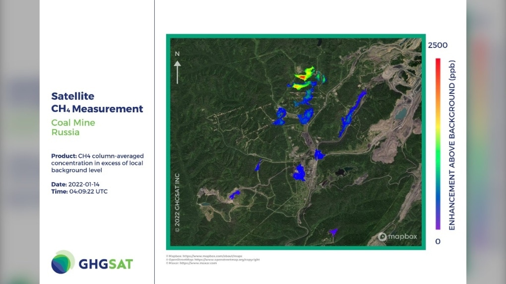
World’s Biggest Methane Leak Detected in Russian Coal Mine

World’s Biggest Methane Leak Detected in Russian Coal Mine

World’s Biggest Methane Leak Detected in Russian Coal Mine

Emission enough to power millions of homes has been detected by GHGSAT at Raspadskaya coal mine in Kemerovo Oblast.

GHGSat Methane Coal

A coalmine in central Russia, the country’s largest, has become the epicenter of biggest methane leak ever recorded. As per latest data released by GHGSat, about 90 tons of methane per hour was being released from the mine in January, when the gas was first traced to its source. Methane is 80 percent more powerful than carbon dioxide. It is an unavoidable by-product of mining, with pockets of the gas released as seams are opened.

Raspadskaya emissions exceeds any prior emissions anywhere in the world. In October 2015, the largest man-made methane release in US history occurred at an underground natural gas storage facility in Aliso Canyon, near Porter Ranch, Los Angeles. Estimates put the rate of release as high as 58 tons per hour. The carbon footprint of the leak, which took four months to fix, was greater than that of the Deepwater Horizon disaster.

In May 2010, 66 people were killed at Raspadskaya mine, Russia’s largest, in an explosion caused by a build-up of methane within its 220 miles of tunnels.

“The Raspadskaya leak would add about 25% to the greenhouse gas emissions of burning any coal produced from the mine,” the Guardian quoted Brody Wight, Director of Energy, Landfill and Mines, GHGSat, as saying.

Methane plays a big role in global warming, and this recent leak would exacerbate mitigation efforts.

Alarming emission risk

Emissions from the mine stood at 87,251 kg per hour and 764,319 tons per year. There were 13 simultaneous leaks at Raspadskaya in Kemerovo Oblast, Russia, on 14th January, 2022, with more plumes observed on 22nd January and 27th May.

Aggravating the environmental pollution, 13 distinct methane plumes were measured during a single satellite pass — ranging in size from 658 to 17,994 kg/hour.

If the total rate of release sustained for a year, the mine would emit 764,319 tons of methane, which can power 2.4m houses.

Subsequent observations found that the underground mine consistently expels large quantities of the gas, which has a climate-warming potential c.84 times greater than CO2 over 20 years.

How GHGSAT detects methane?

GHGSat has been  the first to measure emissions from open cast coalmines from space, a source that has traditionally proven challenging to quantify.  In 2018, it identified a malfunctioning oil well in Turkmenistan while on a scientific mission to find mud volcanoes. Between February 2018 and January 2019, this released c.142,000 tons of methane.

Their satellites also recorded an open cast facility in Kazakhstan generating 54,000 kg/hr of the gas during passes in January and February this year.

GHGSat’s new observations build on this work and previous studies. Due to the unique, high-resolution instruments on board the company’s six satellites, which can image down to just 25m x 25m on the ground, researchers can now pinpoint the exact source of methane leaks.

Emission rates too can be precisely measured, as the sensor’s accuracy has been validated in third-party blind experiments involving controlled releases of methane. This data can play a vital role in helping mine operators better understand their emissions and prioritize coal mine methane (CMM) capture projects.

Trimble announces deployment of Applanix’s POS LV to enable broader autonomy capabilities

0
Trimble announces deployment of Applanix’s POS LV to enable broader autonomy capabilities

Trimble announced today the first deployment of its map-based localization system for land-based autonomous vehicle applications. IHI Corporation, a heavy industry manufacturer based in Japan, will retrofit its existing container and haulage trucks with a customized Applanix POS LV system as part of its broader autonomy capabilities for the transport of goods around industrial facilities.

Map-based localization provides precise positioning and orientation estimation, augmenting GNSS/inertial data, which is critical for safe and efficient autonomous vehicle operations. The ability to provide IHI Corporation a full workflow and real-time data ensures seamless integration into IHI’s truck design.

The custom-built, locally supported system leverages Trimble’s innovative engineering capabilities and technology to provide reliable performance across a variety of challenging environments. Using this system, IHI Corporation can provide robust positioning for their autonomous fleet without additional site infrastructure, lowering capital expenditure (CAPEX) costs and improving scalability.

Tailoring POS LV to work within IHI’s unique specifications and existing autonomous platform, the map-based localization system couples an inertial navigation system (INS) with simultaneous localization and mapping-based (SLAM) capabilities, and works with several types of sensors, including LiDAR for IHI. POS LV provides an accurate base map using post-processed data and localizes vehicle positioning in real-time, enabling the reliable and safe autonomous operation of industrial vehicles.

IHI continually enhances its work environments, while also compensating for varying labor scenarios and personnel shortages. This makes the need to automate transportation critical to operations. The complexities of the evolving industrial manufacturing environment require solutions that can be tailored to a customer’s specific application requirements. By partnering with Trimble, IHI can develop a retrofit system that addresses two major challenges—affordability and consistent reliability—within the autonomous operation of large-scale industrial equipment. Customers such as IHI rely on Trimble to create autonomous solutions that enable them to meet their strategic goals no matter where they are on their journey to autonomy.

ST Engineering iDirect achieves ESA certification, advancing aerospace manufacturing capabilities

0
ST Engineering iDirect achieves ESA certification, advancing aerospace manufacturing capabilities

The spaceflight industry planted a new flag in Belgium today as ST Engineering iDirect announced that it will be manufacturing components used in flight systems for spacecraft to European Cooperation for Space Standardization (ECSS) standards at its Manufacturing Competence Center (MCC) in Erpe-Mere, Belgium.

Following the stringent certification process by the European Space Agency (ESA), ST Engineering iDirect will help to make components for QinetiQ, the British multinational defense and space technology company. This makes ST Engineering iDirect the sole subcontracting company offering these services in Belgium.

ST Engineering iDirect’s MCC will provide its specialist manual and automated soldering services to QinetiQ for its ADPMS-3 satellite board computer systems and for the International Berthing and Docking Mechanism (IBDM) currently in development with ESA, enabling vehicles carrying cargo or passengers to dock softly, with less force. Furthermore, it will also assist in building components for payload projects.

“The process of becoming ESA-certified has been incredibly thorough in assuring the quality, the education and capabilities of the MCC and its workforce. This accreditation and the additional commencement of our automated soldering activity will open doors for our company to broaden our footprint in the industry, as well as strengthen the Belgian spaceflight ecosystem,” said ST Engineering iDirect’s MCC Sales and Marketing Manager, Danny De Smet. “We’re very appreciative of the support from QinetiQ and their recognition of our capabilities in providing larger scale component soldering.”

Erik Masure, QinetiQ’s Managing Director in Belgium said, “We’ve been consistently impressed by ST Engineering iDirect’s – and specifically the MCC team – ability to rise to the challenge of becoming ESA-accredited over the past few years. Working with a partner in close proximity to our space facilities in Kruibeke, Belgium, is incredibly beneficial for the success of our relationship. We look forward to deepening our partnership and working together in the future.”