The spaceflight industry planted a new flag in Belgium today as ST Engineering iDirect announced that it will be manufacturing components used in flight systems for spacecraft to European Cooperation for Space Standardization (ECSS) standards at its Manufacturing Competence Center (MCC) in Erpe-Mere, Belgium.
Following the stringent certification process by the European Space Agency (ESA), ST Engineering iDirect will help to make components for QinetiQ, the British multinational defense and space technology company. This makes ST Engineering iDirect the sole subcontracting company offering these services in Belgium.
ST Engineering iDirect’s MCC will provide its specialist manual and automated soldering services to QinetiQ for its ADPMS-3 satellite board computer systems and for the International Berthing and Docking Mechanism (IBDM) currently in development with ESA, enabling vehicles carrying cargo or passengers to dock softly, with less force. Furthermore, it will also assist in building components for payload projects.
“The process of becoming ESA-certified has been incredibly thorough in assuring the quality, the education and capabilities of the MCC and its workforce. This accreditation and the additional commencement of our automated soldering activity will open doors for our company to broaden our footprint in the industry, as well as strengthen the Belgian spaceflight ecosystem,” said ST Engineering iDirect’s MCC Sales and Marketing Manager, Danny De Smet. “We’re very appreciative of the support from QinetiQ and their recognition of our capabilities in providing larger scale component soldering.”
Erik Masure, QinetiQ’s Managing Director in Belgium said, “We’ve been consistently impressed by ST Engineering iDirect’s – and specifically the MCC team – ability to rise to the challenge of becoming ESA-accredited over the past few years. Working with a partner in close proximity to our space facilities in Kruibeke, Belgium, is incredibly beneficial for the success of our relationship. We look forward to deepening our partnership and working together in the future.”
ST Engineering iDirect’s MCC has Factory of the Future status, the highest possible recognition for the manufacturing industry in Belgium. It provides manufacturing and repair services and specializes in electronic assembly, testing and repair for a range of customers in the satellite and aerospace sectors including OHB and Panasonic.
For most of human history, the ability to pinpoint your location would have been nothing short of magic. These days, thanks to Global Navigation Satellite System (GNSS) technology, it barely raises an eyebrow. Yet, as ubiquitous as GNSS has become in commercial, civil, and military applications, it’s still not a perfect solution. The biggest issue: unreliability.
As long as receivers have clear line of sight to GNSS satellites, positioning works great. And most of the time, they do — especially in the air, on sea, or on highways. Unfortunately, in many locations, buildings and terrain can interfere with satellite signals, leading to significant errors and even loss of fix. And positioning systems typically have no way to predict when and where these significant errors will occur.
Technologists have long viewed this as an inherent, if unfortunate feature of GNSS. After all, we can’t change the laws of physics to make satellite signals immune from reflection or interference. With new 3D-mapping techniques, however, we can do something just as useful: understand exactly where and when GNSS can be trusted, and where it can’t. Now, industry leaders are using these techniques to radically improve positioning for current and emerging use cases. And they’re rewriting the rules of what’s possible with GNSS.
Navigating GNSS Challenges
The strength of GNSS technology lays in its use of constellations of satellites. Receivers only need clear line of sight to a few of them to accurately establish position, and most of the time they can get it—even when most satellite signals are blocked. The problem: GNSS satellites never stop moving, orbiting the Earth at about one degree per minute.
If you’re calculating position in an urban region with tall buildings then, you could usually trust GNSS signals, but there’s been no way to know when you shouldn’t. Reflections off buildings in particular can throw off positioning by tens of meters (Figure 1). It’s not like positioning systems can just avoid bad spots either, since they change as satellites move, literally second by second.
Figure 1. GNSS Signal Interference
So far, this issue hasn’t been a deal breaker for most commercial GNSS applications. As we trend towards more ambitious use cases though—such as autonomous vehicles or drone-based delivery—reliable positioning data becomes absolutely critical.
Changing the Game with 3D Mapping
Today, industry leaders are applying new techniques to solve this problem. By combining GNSS data with high-resolution 3D maps, they can identify exactly where GNSS signals will be available and can be trusted, and where they can’t, second by second. And they can offer these insights (typically as a cloud service) to any commercial customer or government agency that could benefit from more reliable positioning.
Here’s how the technology works: Companies aiming to provide GNSS reliability services start with a fine-grained 3D map of a given area. For aviation and automotive use cases, organizations are using mapping solutions that deliver native resolutions down to 30 centimeters, with the ability to derive even higher-definition resolutions. They also use techniques like multispectral imaging to differentiate between natural and man-made materials, penetrate through smoke, and more.
Once these companies have a high-fidelity map, they create an overlay of observable points across that area, such as breaking the region up into one-meter squares. Then, from each of those points, they determine which satellites will be clearly visible at a given time. There are multiple ways to make this determination. The most popular include:
Shadow matching: This technique, often applied to smartphones, creates a 3D map-aided (3DMA) grid showing predicted GNSS signals for a given area. It then compares those predictions against measured signals in real time to identify and correct for errors.
Ray tracing: In other venues—especially aviation, where more granular details on elevation and azimuth are needed—leading solutions use ray tracing from each observable point up to each satellite in a constellation. They do this repeatedly, building a data set that shows which satellites are line-of-sight (and therefore, reliable) second by second, across every meter of a 3D map (Figure 2).
Figure 2. Pinpointing GNSS Reliability via Ray Tracing
Next-Generation Positioning in Action
GNSS reliability solutions apply different techniques for different use cases. In addition to how a system calculates line of sight, the biggest factor dictating a solution’s approach is how quick the calculation needs to be and how many points. There are two main options:
Device Computation for a single point: For applications with ample local computing resources, where some amount of latency in calculating positioning is acceptable, and the device only wants to know a single (or few) points a device centric solution is appropriate. This approach is used in most smartphone-based scenarios, where applications have a powerful endpoint device, typically a strong network connection, and do not require precision measured in milliseconds.
Cloud based scaled solution: There are many scenarios, however—such as aerial drones and driverless vehicles—where the entire environment around the vehicle or route are needed quickly and the vehicle does not have computation dedicated to GNSS. In these cases, GNSS cloud services can offer real-time predictive insights. They perform all calculations for an area ahead of time in the cloud, forecasting some period into the future. Positioning engines can then understand in advance and real-time exactly where they can trust GNSS signals and where they can’t, and proactively mitigate issues. Or better yet, use he predictions to extract the best signals possible and improve performance.
Looking Ahead
Implemented effectively, early integrations have shown that these techniques can literally double the accuracy of GNSS systems. But the potential goes much farther across multiple aviation, automotive, and military scenarios:
Aviation: 3D mapping techniques enable smarter flight planning, allowing organizations to know ahead of time where and when it’s safe to fly, and adjust flight times to optimize positioning reliability. Or, in large-scale drone applications like drone-based delivery, companies can choose to routes known to be reliable at specific times.
Automotive: Automakers can use the predictions in real-time to improve the performance of the GNSS system and improve safety by knowing where and when GNSS is reliable as a part of all the sensors on the car.
Military: Mission planners can improve risk analysis by understanding best- and worst-case scenarios for GNSS performance in a given area. They can also evaluate the integrity of GNSS signals in the field, including detecting when positioning data is being blocked or spoofed.
These are just a few of the possibilities. With new 3D mapping techniques, we can transform GNSS from “usually reliable” to highly accurate. And we can start tapping the potential of positioning for applications we’ve only begun to imagine.
The European geospatial market is moving forward and evolving, starting from single data asset capture to integrated workflows to Cloud platforms. It's been quite a journey and the momentum is not going to get any slower. The private industry, government, and academia — the three pillars of the geospatial ecosystem — need to prepare themselves because there will be much to do.
In recent times, despite the havoc wreaked on people and businesses by the COVID- 19 pandemic, the geospatial industry has witnessed a surge in demand for geospatial-based value-added services, technology innovation, and digitalization of systems and processes. As the power of location moves into the hands of people, the global geospatial market is estimated to reach USD 1.44 trillion by 2030. Europe is one of the major players in this trillion dollar economy. It is a region where geospatial tools are indispensable in governance, environmental management, society, and businesses. According to the European Geospatial Business Outlook Dossier published by Geospatial World, the European geospatial industry is forecasted to grow at a CAGR of 11.61% between 2021 and 2025, and touch USD 155 billion.
This growth is attributed to the evolving role of national geospatial agencies, enhanced workflow integration in the economic sectors, changing business models, and an evolving legislative environment. These points were reiterated by European geospatial experts at the recently held GeoBuiz Europe Summit (pre-conference of Geospatial World Forum 2022) — the experts discussed directions and dimensions, technology trends, and business models of the European geospatial market. Here are some excerpts from the panellists at the Summit.
Technology drivers of European geospatial industry
In Europe, the digital infrastructure (sensors and IT) is going to be the major technology driver for the geospatial industry, followed by artificial intelligence (AI), machine learning (ML), and deep learning (DL). These technologies are being swiftly adopted by organizations for the purpose of data processing and analytics, as Europe has one of the biggest Earth Observation (EO) programs. According to Elly Perets, CEO, Asterra, “What people are looking for is not just data but analytics and what action can be derived from it. EO is changing the way data is going to drive our lives.”
Drones/UAVs are rapidly becoming the tool of choice for surveying and collecting high quality real-time data in Europe. Christoph Strecha, CEO, Pix4D, spoke about the strategic importance of drones in the geospatial arena: “In order to make digital transformation faster, the data acquisition devices need to be easy and accessible not only to the professionals but to almost every worker.”
Christoph Strecha
CEO, Pix4D
Geospatial technologies are now ubiquitous across different sectors. For example, the use of GEO-BIM and digital twins is increasing in the infrastructure and construction industries. “Digital twins can mean a single asset, critical infrastructure, or entire cities… the task starts at the design phase but goes further in the full management of the project and this is where the value of geospatial lies,” said Antonello Giuliani, EMEA Sales Director, Trimble.
Jaime Sanchez, Head of Solutions, CARTO, highlighted that GIS was now being used more and more outside of traditional and siloed GIS departments and tools: “Geography is changing faster than ever before. We have a new set of requirements for spatial analysis.” He also added that the governments in Europe are looking to the commercial geospatial sector for innovative ideas to solve problems like climate change, building sustainable infrastructure, and so on.
Leading Technology Drivers of European Geospatial Industry
Leading market drivers
According to the European Geospatial Business Outlook Dossier, amongst the leading market drivers of the European geospatial industry is the evolving role of national geospatial institutions, as they tranform from providing just data to providing knowledge. For instance, national geospatial agencies, in collaboration with other government departments, are encouraging the development of National Digital Twins in countries such as the Netherlands, Germany, and Sweden.
A second driver is enhanced workflow integration across new vertical domains — the idea now is not to use products or technologies in silos but as complete solutions to provide end-to-end services. This further drives a lot of collaboration and agreements between geospatial industry, non-geospatial industry, and governments. For example, different utility companies work together and partner to help create digital twins of the underground or utility infrastructure.
During the GeoBuiz Europe Summit, Mark Haaksman, Senior Manager Business Development Digital Cities, Royal HaskoningDHV, observed that the role of government is to create standard ways for people to work together, so they can provide data that supports resilient utility infrastructure. “The city of Amsterdam is a good example. The Amsterdam Institute for Advanced Metropolitan Solutions (AMS Institute) tries to bring all the stakeholders together not just for science or education but also for city operations and to create open strategic alliances,” he said.
Mark Haaksman
Senior Manager Business Development Digital Cities, Royal HaskoningDHV
Another example is Belgium — in order to build the underground network here, the government is making it obligatory for companies to divulge where they will be working in the coming six to nine months. As the utility owners share their locations, this gives an opportunity for others to do the same as well. Luc De Heyn, Chief Commercial Officer, Merkator, explains: “The goal is to have the street opened only once so that the telecom company can put new fiber and the electricity company can renew its cable, and so on.”
Luc De Heyn
Chief Commercial Officer Merkator
The government’s role is also crucial in making spatial data available to businesses and civil society to use for sustainable infrastructure. TerraNova, the European Landscape Learning Initiative based in The Netherlands, has been creating a reference architecture for a Digital Twin for the physical surroundings. “The government is standardizing the use of data for digital twins,” added Haaksman.
Pooja Mahapatra
Owner - Geospatial, Fugro
Evolution of business models
The evolution of business models is on the rise in the European geospatial industry. Many geospatial companies are exploring new business models, transitioning, notably, from traditional license/subscription- based models to the X-as-a- Service business models. The X in this model continues to grow with innovations and new technology directions, and will contribute to the scalability and application of geospatial information and technologies in the long run. Sean Wiid, CEO, UP42, elaborates: “When we talk about data, infrastructure, and analytics-as-a-service, we are providing access to commercial algorithms from a range of companies; I think this is a really important mechanism that we have built to push the technology from the industry into the hands of developers, ultimately providing a complete solution to the users.”
Leading Market Drivers of European Geospatial Industry
Companies foresee various benefits of adopting X-as-a-Service in creating and providing integrated solutions, adding features, innovating, faster product development, and reducing risks of R&D. Andreas Gerster, Vice President Software Technology Solutions, Hexagon, said, “In the end, success is more than just a collection of tangible items. It’s the knowledge and the wisdom and how to combine them, how to use them in a meaningful way.”
Acknowledges Philip Mott, General Manager, Esri Europe, “Technology is moving fast, it’s difficult to keep up with it. And we are all desperate to try and deliver optimum value to our customers. X-as-a-Service is typically connected online — they stay fresh, bug-free, with the latest versions of the software to do your best work, that’s what everybody wants.”
The European geospatial industry is also driven by intra- and inter-industry collaborations and partnerships that offer wholesome solutions to users, expand market outreach, derive benefits of economies of scale, and save resources on independent development of digital technology strengths. In this context, as per the Dossier, the European geospatial industry is still looking at the subscription/ recurring business model as its second most preferred method to capture new business segments.
GeoBuiz Europe: Session on Technology Innovations and Platforms: Driving X As A Service
Pier Francesco Cardillo
Information Technology and Digital Transformation, e-GEOS
When it comes to subscription models, Phoebe Parry- Crooke, Partnerships Manager,what3words, believes they give great flexibility to the end-users: “We are thinking how to give a customized and simple experience to the users.” But this doesn’t mean that it is a silver bullet for all the problems. “Procurement is a massive headache; people are not going through that on a monthly basis. We speak to clients on a one-to-one basis to see what works best for them,” she explained.
Europe’s public policies provide a conducive environment
for driving geospatial industry growth. The European Union
(EU) supports SMEs, start-ups, entrepreneurs by establishing
innovation hubs/clusters.
Public policies and accelerator programs
Europe’s public policies provide a conducive environment for driving geospatial industry growth. The European Union (EU) supports SMEs, start-ups, entrepreneurs by establishing innovation hubs/ clusters. The EU has developed geospatial policy frameworks, viz. INSPIRE Directive (2007/2/EC), and EU Space Strategy and Space Policy, and allied policy frameworks to support the innovations happening in the industry and the economy of the region.
The European Union Agency for the Space Programme (EUSPA) provides safe and secure European satellite navigation services while promoting the commercialization of Galileo, EGNOS, and Copernicus data and services. Reinhard Blasi, Acting Head of Communications, EUSPA, elaborated on the various initiatives of the organization: “We sense the need to have a more specialized funding instrument, for example, innovative receivers, chipsets, and devices that take advantage of Galileo. We are also in charge of the European Commission’s Cassini program, where we take care of the space segment, that is, covering the start-ups gaps.”
Massimo Comparini, Deputy CEO, ESVP Observation Exploration Navigation, Thales Alenia Space, spoke about the upstream and downstream space infrastructure and applications, “We are looking at more commercially- driven constellations. We’re talking about an information- driven business — how to combine geospatial data with the huge layers of other information.” He also said that the open data policy is extremely important to grow a number of innovative companies working on the downstream: “We don’t create competition for the European companies based on the fact that someone can simply catch data and come to Europe to sell. What we have done in the last 20 years is based on a really balanced and good mix of public policies and private investments.”
The space start-ups, acceleration programs, and investment scenarios are critical to the growth of the European geospatial industry. The region mainly attracts higher investments in the space ecosystem. The space start-ups in 2022 had already raised more than USD 350 million by Feb 2022, which is almost half of the total fundraising in 2021. With the increasing number of downstream applications in the space ecosystem, and the increasing number of innovative and vertical-based applications, the geospatial industry will expand significantly. Rainer Horn, Managing Partner, SpaceTec Partners, said, “The funding sources and the ecosystem have gotten a whole lot smarter and much more complete in Europe. We have engagement programs, hackathons, idea competitions and so forth from the European Commission and the European Space Agency (ESA). Then, there’s a whole lot of private and increasingly public accelerators who are helping to inspire new talent.”
On the other hand, the United Kingdom released its space strategy last year. The first step by the UK was to state clearly what they were trying to achieve and ensure their public sector bodies had a clear mission so people. “It’s important to have clear strategies because otherwise the industry doesn’t know where the public interest is going to lie and you could end up with one of those data custodians accidentally treading on an area of expansion for the commercial industry. So we have got UK’s geospatial strategy which was initiated in 2020 being refreshed every year,” said Nigel Clifford, Deputy Chairman, UK Geospatial Commission.
Lea Bodossian, Secretary General & Executive Director, EuroGeographics, quoted the Dossier, saying Europe’s Open Data Directive and the European Data Strategy is a pioneer with an innovative approach towards building an attractive, secure, and dynamic European data economy that will benefit the overall economy and society. In Europe, everyone has access to the data from the NMAs (national mapping agencies) as they have embraced the public policy of open data. “The NMAs are also strongly encouraging the ecosystem inside the EU. Each EU country has 30 to 50 companies and they are all trying out the open data and to create value for the European economy,” she highlighted.
GeoBuiz Europe: Session on Public Policies and Commercialization of Geospatial and Space Industry
The Netherlands has a spatial planning policy and it’s also planning to have a Digital Twin strategy. “The idea is to have a Digital Twin of the physical environment of the Netherlands. There are a lot of policies around energy transition, climate adaptation and we also need one million houses in the country and that is only possible when we have good spatial data infrastructure,” explained Noud Hooyman, Chief Geoinformation Officer, Ministry of the Interior and Kingdom Relations, The Netherlands.
Towards a green future
Throughout the daylong panel discussions at the GeoBuiz Europe Summit, the words sustainability, net zero emission, climate change, and global warming were echoed. All trends and dimensions were eventually pointing towards these concern areas and the European Green Deal. The European Commission, in December 2019, unveiled its flagship action plan to tackle climate change, the European Green Deal. The EU aims to become the first resource-efficient and competitive economy without net emissions of greenhouse gases by 2050.
The Green Deal covers ten policy areas and there is a call for private sector involvement and fostering innovation and digitalization. With this focus the implementation of geospatial data and technology is only going to expand. Anthony Baker, CEO, Satellite Vu, highlighted the value of open and commercial EO data: “As an industry we are making great progress and supporting the Green Deal. The radar satellites are identifying floods, whereas ESA is measuring climate change through microscopic details. The question is how to do this all at greater scale with both the scientific and commercial satellites? That’s the balance we need to find.” Various space agencies give open and free data but for agile and effective response, commercial EO data makes sense.
Echoing the same thoughts, Pacome Revillon, CEO, Euroconsult, said that the industry has been supportive of the Green Deal: “It’s a transformative time for the industry but the challenge is also how can the Green Deal policy turn into actual national policy and regulation, and create an ecosystem where everyone can offer services.”
Arnout Desmet, Vice-President – Maps, TomTom, shared an interesting case study on GNSS data and AI/ML. “We have access to 600 million connected devices that provide us on a day-to-day real-time with GPS trace data, which, with the help of AI/ML, is converted into congestion or traffic index. Every year we publish this for 400+ cities; it is useful for the road authorities to understand the nature and the evolution of congestion and its impact on liveability of cities. This year, as a pilot for four cities — Paris, Berlin, Amsterdam, and London, we also connected this data with carbon emissions. London had the highest emission levels. Imagine the impact you can have as authorities in tackling the climate crisis?” he asked.
Hugo De Groof
Policy Officer, DG Environment – European Commission
What kind of space infrastructure and geospatial knowledge would be adequate to achieve the Green Deal? Hugo De Groof, Policy Officer, DG Environment – European Commission, said, “The challenge lies in implementing the Green Deal and this is where geospatial technologies are going to play a big role. We have the ambition in Europe to create a Digital Twin of the Earth that will exist at all scales. Imagine the amount of data that will be collected and shared. That’s the reason we need strong public-private partnerships.”
Though there’s ‘humongous’ geospatial data coming from different sources, a serious data gap in the global fight against climate change still persists. Carles Franquesa, Founder & CEO, Aistech Space, shared an interesting outlook: “The complicated thing is not to cover the data gap but how we can generate future business with this amount of data. Initially, governments will push and will lead the utilization but at the end we need to create a business. We need to provide a specific value for the companies and the society as well.”
The European geospatial market is moving forward and evolving, starting from single data asset capture to integrated workflows to Cloud platforms. It’s been quite a journey and the momentum is not going to get any slower. The private industry, government, and academia — the three pillars of the geospatial ecosystem — need to prepare themselves because there will be much to do. Innovation doesn’t happen in isolation and opportunities and challenges in today’s demanding environment will need to be faced together.
Climate change is massively disrupting the way organizations manage physical and financial risk. Existing climate risk models predict where and how physical risks will increase, in terms of severity and frequency. However, awareness of climate risk is not enough. The market demands complete, actionable solutions that enable asset owners to pinpoint risk, prioritize where they protect their assets, and measure improved climate resilience.
Climate resilience analytics goes beyond climate risk modeling to inform physical risk mitigation and strengthen resilience. It pinpoints where climate risks threaten assets, and prioritizes threats.
Denver-based Teren is a leading climate resilience analytics company. By harnessing the plethora of remotely sensed data from orbit and airborne platforms, Teren delivers hyper-localized, asset-level insights for managing climate risk and building resilience over time.
Organizations have a growing need for ESG, and investors will take the ESG performance of a company into account. “We aim to offer the resources for companies to better their ESG ratings across the board. We’ve also expanded to include solar organizations in our customer lineup this year. We continue to lead the conversation on climate risk analytics and help organizations build out their ESG programming,” said Toby Kraft, CEO & Founder, Teren in an interview with Geospatial World.
Excerpts
How can geospatial data usage help companies in all industries become smarter about climate resilience?
Geospatial data is the currency for climate adaptation. By leveraging the most contemporary methods of collecting (airborne or satellite), processing, analyzing, and tracking change over time, companies can keep their finger on the pulse of what’s happening around their assets. By investing in higher spatial and temporal resolution geospatial data, companies have more assurance that they are allocating spending to suitable locations and reducing business risk.
What are the challenges that major companies face and how do you help them deal with those challenges?
Today, natural disasters and extreme weather events are growing in size and frequency. Natural disasters can damage infrastructure integrity, safety, and reliability from direct threats such as floods and wildfires to indirect threats including hydrologic, vegetative, geologic, and soil conditions. It is crucial for business owners to ensure that their assets are built and operated with climate resilience.
Teren Essentials Landslide – Shows threat of landslide (Red = Highest Threat)
Remote sensing is a fast and effective solution for identifying physical risk, monitoring potential threats, and building climate resilience. Through remote sensing data, companies with physical assets and infrastructure can better understand the threats at hand, make informed decisions about mitigating risk, and allocate resources proactively to avoid costly incidents and reactive repairs. This can be done far faster than traditional methods of surveying, which require teams of professionals to be physically present – often in difficult and dangerous terrain.
This data is specifically beneficial for pipeline operators and electric transmission companies. Still, the data also can be helpful for commercial and residential property owners, clean-energy companies, including renewable power generation, and civil engineers developing infrastructure.
Our tech delivers hyper-localized, asset-level insights for managing climate risk and building resilience over time. We solve complex problems by applying modern data science techniques, geo-intelligence and high-performance computing to deliver timely, actionable results. Teren works with asset owners, developers, engineering firms and insurers to pinpoint risk, reduce exposure and improve climate resilience
Recently you announced raising $4 million in seed funding, led by Allos Ventures, how are you planning to utilize the funds in climate change initiatives?
We’ve experienced an uptick in demand for proprietary analytics – and as we expand, we are developing solutions that will enable the insurance, solar, environmental and transportation industries to address real climate risk issues affecting their assets.
Teren Premium Change Detection – Teren’s Continuous Change Detection analytic compares landscape features and terrain between two temporal datasets to detect subtle landform or surface structural changes. The algorithm first removes vegetation and elevation biases from the two temporal datasets under comparison. Then, the analytic measures vertical shifts greater than 1 foot within 60 feet of the centerline. Teren Premium
We are currently using the funding to expand our workforce by 40% to address the fast-growing remote-sensing market estimated to exceed $13 billion by 2027, which will ultimately help us address climate resiliency in infrastructure across the country.
Please elaborate the key ways in which companies can start using geospatial data to further strengthen their defense against climate change and climate risk?
Most companies are becoming acutely aware of climate change’s risks to their assets. If they aren’t, there are many climate scenario models to understand their exposure to general risks, such as wildfires, flooding, drought, or increased precipitation.
Teren Essentials River Scour – Threat of river scour (Red = Highest Threat
Organizations can take advantage of geospatial analytics derived from remotely sensed data to pinpoint, prioritize and monitor hazards accelerated by these changes. They can also develop an effective ESG strategy through the targeted management of surface conditions to mitigate climate vulnerabilities, improve climate resilience and report back to shareholders.
What technologies do you use to develop solutions for insurance, solar, environmental and transportation industries to address real climate risk issues affecting their assets? How do you develop analytics to improve wildfire mitigation and responses?
We are launching three new products: one to help businesses pinpoint the highest climate and environmental risk; another to reduce field labor, survey and earthworks cost by using high-fidelity data to inform site design and planning; and the final one to help organizations mitigate wildfire risk. Through all of these products, our primary focus is to identify where an asset is most vulnerable to help businesses better determine where prescriptive monitoring and analysis would be most effective so that organizations can mitigate risk and strengthen their climate resiliency.
Teren Premium Centerline Threat – The relative level of threat posed by existing geohazards and problematic hillslopes is summarized to the pipeline in three-meter segments and averaged based on a sliding mile to create the Centerline Risk analytic.
What are the kind of business models that you anticipate in the near future?
There are various use cases for our data and analytics – one of the business models that continues to prove popular with our customers is subscribing to regular data updates. Instead of receiving data about a region and then being forced to rely on it for several years before the next survey, we can offer a data subscription.
This model will ensure the new collection and analysis of data twice a year across many thousands of miles or acres of assets for the customer may be responsible. We see this as the future of how customers receive terrain-threat data in a rapidly changing environment.
Location analytics gives retailers a competitive edge, enabling them to assess consumer metrics, cater to demand-supply dynamics, make better decisions, anticipate footfall, and get more in sync with market shifts.
The retail sector is undergoing a massive shift, with data and technology as major growth drivers. Today’s business leaders are more open to adopting technology to make data-driven decisions, strengthen their businesses, and enhance analytics capabilities.
Location technology empowers brick and mortar store owners as well as e-commerce retailers to get a complete understanding of the consumer journey, connecting both online and offline touchpoints for optimization and budget allocations. Closed loop attribution enables marketers to gain a holistic, full-funnel understanding of the impact of their media, based on all the key performance indicators (KPIs) that matter to them, irrespective of whether they are related to in-store conversion.
For example, this technology enables retailers to measure behaviors like click-and-collect and BOPIS (buy online, pick up in-store), or make an online purchase on being exposed to the billboard. Retailers and restaurant owners use location intelligence (LI) extensively to stay on top of their game.
In a recent study by 451 Research, one data science executive working for a retailer stated: “LI means everything for the company. It’s very important to keep the doors open for our business.” In fact, 74% of commercial real estate executives view location technology as a highly strategic investment that drives competitive differentiation, and 77% agree that using LI for site selection is highly important to maintain their competitive advantage.
Location technology for site selection
LI can help retail businesses in multiple ways (See Figure. 1). It provides demographic information and ensures store location is accessible to/by a certain target demographic. Through the idea of routing, it can calculate how far most customers are willing to travel to visit a store and the impact this has on store performance, which, in turn, impacts the investment decisions on where to target and advertise.
“Location technology has a huge benefit for all businesses with physical touchpoints to their target audience. We see a lot of value in particular with retailers, restaurateurs, gyms, and health and beauty service providers, as well as shared mobility operators and delivery services,” says Henning Hollburg, Founder and CEO of Targomo.
Figure 1: Hollburg points out six ways how LI helps in the growth of retail
Hollburg points out three ways how restaurateurs use LI: first, by checking whether a location is suitable for a particular restaurant concept when opening a new restaurant or planning an expansion; second, by checking which restaurant concept is suitable for a particular location; and third by predicting relevant KPIs such as sales or number of visitors. “For restaurants and their offerings, for example, the surroundings are very important. Is it a classic shopping street, a nightlife district or an office area? Here we draw many insights from points of interest and competitors,” he adds.
Location technology has a huge benefit for all businesses with physical touchpoints to their target audience. We see a lot of value in particular with retailers, restaurateurs, gyms, and health and beauty service providers, as well as shared mobility operators and delivery services
Henning Hollburg
Founder and CEO, Targomo
Movement data, which provides up-to date insights about where the most foot traffic is traced, is very insightful for estimating demand at a particular location. For other businesses, which attract visitors themselves, good accessibility by car and/or public transport can be decisive. “We offer our customers individual success driver analyses, in which we determine exactly which location factors are decisive for their particular business model,” Hollburg adds.
For delivery services — especially those with a fast delivery promise — it is important to combine the analyses with travel time calculations. This makes it possible to find out exactly what kind of people one would reach from a warehouse in 15 minutes by e-bike, for example.
Analyze customer behavior
By using conventional methods, retailers only understand half of a customer’s journey. With location data, they can see the full picture. “LI provides visibility into what is taking place outside of a retailer’s four walls, showing where customers go before and after visiting a store, where else they shop, how far they travel to reach a store, and so much more,” says Ariel Eck, Director of B2B Marketing, Foursquare.
Retailers can enrich their customer profiles with this information, combining location data with other datasets, such as transaction data and online behaviors, in order to power personalization at scale.
LI provides visibility into what is taking place outside of a retailer’s four walls, showing where customers go before and after visiting a store, where else they shop, how far they travel to reach a store, and so much more.
Ariel Eck
Director - B2B Marketing, Foursquare
Retailers don’t have to rely only on hardware installed in stores, such as beacons or cameras, in order to understand consumer behaviors. As the use of mobile devices has become universal (with 84% of the world’s population now owning smartphones), the volume of data from mobile devices has skyrocketed (45% of consumers use their phones for in-store price comparisons, and 65% of consumers have retailer applications on their phones).
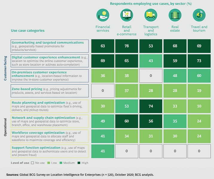
A survey conducted by a group of experts for BCG study in 2021, found that respondents use mapping and geospatial data across eight categories (See Figure 2).
Figure 2: Executives in multiple industries use LI in a wide array of use cases
“One type of mobile data in particular presents unprecedented opportunities for retailers — location data. Location data from mobile devices empowers retailers to answer key questions, uncover hidden insights, improve customer experiences, and achieve better business outcomes. In fact, 95% of executives say that geospatial data is important to getting business results today, and 92% say it will become ever more essential in the next three to five years, according to a recent BCG study,” says Eck.
Customer records appended with location attribution can produce greater insights into targeting, acquisition, and retention and improve profitability.
Andy Peloe
Product Management Director Precisely
Indoor Location Marketing report shows that the demand for real-time location services — indoor positioning — will only increase in the future, and will become a USD 19.7 billion industry by 2026.
“Customer records appended with location attribution can produce greater insights into targeting, acquisition, and retention and improve profitability. Analytics help to understand who your customers are in terms of location demographic profile and buying habits, behaviors and lifestyle, where one lives and shops, etc. Analytics also help evaluate whether you are targeting the right customers and the right locations in marketing activities,” says Andy Peloe, Product Management Director at Precisely.
Support in strategizing and planning
Location data can help businesses make strategic decisions that improve margins. For example, location data helps organizations analyze footfall data, in combination with location and socio-economic information, to optimize the mix of physical and online locations or to identify new store locations and plan franchise territories.
“Location data helps balance physical and digital presence, helps better understand market opportunity and untapped potential, helps to improve customer experience through tailored marketing, and helps to uncover growth and operational efficiency opportunities,” points out Peloe.
There are numerous types of retail data that can add meaningful insights to a cycle of analysis and application. For location-based data, two of the most relevant types of data are collected about the store and about the customer.
Store location data gets more granular, focusing on geospatial information, which
may include neighborhood traffic, retail foot traffic, point
of interest (POI) visitation data/store
visit tracking, competitor visit tracking, and customer catchment areas.
Thomas Walle
CEO and Co-founder Unacast
“Store location data gets more granular, focusing on geospatial information, which may include neighborhood traffic, retail foot traffic, point of interest (POI) visitation data/store visit tracking, competitor visit tracking, and customer catchment areas,” says Thomas Walle, CEO and Co-founder, Unacast.
“Predict relevant KPIs such as sales or number of visitors. Our analytics have shown that with geo-referenced data, we can predict 80-90% of a branch’s success, be it a store, gym or restaurant. This is preceded by a deeper, AI-based analysis that identifies success drivers. However, as these analyses require an extensive data base, this is only possible for businesses with multiple branches,” adds Hollburg.
Globally, organizations across industries are using big data to improve operations, manage supply chains, and enhance customer service experiences so that they can gain competitive advantage and boost profits. Spatial analysis of big data provides critical intelligence about where, when, and why things happen—intelligence that can’t be obtained from other types of data analysis. To ensure that these insights are accessible in the decision-making process,Esri, the global leader in location intelligence, has releasedArcGIS GeoAnalytics Engine.
This new product provides an intuitive, cloud-of-choice capability that works within existing analysis workflows without requiring additional technology or training. Data scientists can perform spatial analysis wherever their data is stored—in a data lake, a data warehouse, or ArcGIS software—saving the time and cost of moving volumes of data out of cloud environments. The product is a comprehensive library of spatial analytics that is native to Spark, a unified analytics engine for big data and machine learning.
“Industries, from insurance and financial services to defense and intelligence, must increasingly use big data to drive decision-making,” said Lauren Bennett, head of spatial analysis and data science at Esri. “The more data an organization is analyzing, the more critical it is to make real-world sense of it. Geospatial analytics uses location as a connective thread to detect patterns, uncover hidden relationships, and improve predictive modeling.”
Data scientists face several obstacles incorporating spatial analysis into big data analysis workflows. They often lack specialized knowledge and must utilize multiple disconnected packages, and big data processing environments are not built to support spatial analytics.
ArcGIS GeoAnalytics Engine allows data scientists to bridge these operational and expertise challenges while also enabling them to quickly provide stakeholders with results. The product runs in Spark environments commonly used for big data analysis. This includes Databricks, Amazon EMR, and Dataproc, which are Spark environments available from major cloud providers such as Microsoft Azure, Amazon Web Services (AWS), and Google Cloud.
“The combined power of the Amazon EMR big data platform and Esri’s ArcGIS GeoAnalytics Engine allows our customers, regardless of spatial expertise, to seamlessly leverage ArcGIS GeoAnalytics Engine spatial tools and functions in their big data analysis and models,” said Abhishek Ram, head of products, worldwide public sector, at Amazon Web Services.
Xplore Inc., a commercial space company providing Space as a Service®, completed a satellite testing initiative using Microsoft Azure Orbital to conduct satellite operations for the National Oceanographic and Atmospheric Administration (NOAA)’s NOAA-18 satellite. Xplore is operating over a dozen satellites on orbit; the company completed its work with Azure and became one of the first cloud-based ground control software to operate a NOAA satellite.
Xplore integrated Azure Orbital as part of a first-ever Cooperative Research and Development Agreement (CRADA) to demonstrate how commercial services and cloud operations can be used to securely control satellites and acquire data with NOAA satellites.
Lisa Rich, Xplore Founder and Chief Operating Officer said, “the results of this CRADA reinforce the value Major Tom offers its customers. It demonstrates our ability to offer a cloud-based solution and provides NOAA with a path to sustainability and as well, a means by which they achieve redundancy and reliability for satellite operators.”
Legacy satellites, new constellations and experimental satellites benefit from mission operations services offered by Major Tom. In the case of the NOAA-18 satellite, this initiative with Azure Orbital demonstrated technical feasibility of using the cloud to successfully connect with legacy software, designed over 15 years ago. Further, it demonstrates how mission operations through the cloud allow satellite operators to take full advantage of commercial ground stations as a service.
Steve Kitay, Senior Director, Azure Space at Microsoft Corp. said, “Our work with NOAA and Xplore is driving innovation to virtualize satellite ground station operations in the cloud. Empowering agencies to tap into these newest commercial technologies is unlocking new levels of resiliency and global capacity for critical mission operations”
Xplore’s Major Tom service offers a scalable platform with powerful satellite mission operations and planning tools. The cloud-based software allows operators to perform ground station scheduling, satellite tasking and telemetry monitoring, saving money and time on operations. It provides the ability to integrate and control ground segment applications and services, and further de-risks mission operations with features that include out-of-the-box ground network integrations, data analytics, real-time dashboards and a customizable commanding API.
Justin Gronert, JPSS Mission Operations Manager at NOAA said, “Legacy polar satellites require additional support. Under the CRADA with Xplore Major Tom and Microsoft, the capability to provide mission support was demonstrated and we were able to conduct payload data processing via cloud-based mission control.”
Leveraging cloud data allows Major Tom to provide satellite operators with assurance and more resiliency in the system. In the case of a natural disaster, for example, Major Tom can quickly transition all operations to support spacecraft from any location, ensuring reliable continuous operations and resulting in less costly down time.
Lisa Rich said, “with Major Tom, users operate their missions on a secure, unified cloud platform. Data lives in the cloud and can be brought down from any location. Major Tom is a scalable platform that ultimately provides ease of use for a wide range of satellite operators seeking value, reliability and resiliency.”
The UK Geospatial Commission’s policy paper on location data ethics proposing shared values to build public trust in the use of location data is a laudable effort. The paper, Building public confidence in the use of location data, lays down ABC’s of values – Accountability, Bias and Clarity – for the use of location. It takes the position that adhering to these values will maximize public trust and confidence, ensuring that location data can be used, shared and re-used with full public support.
Accountability entails ensuring location data is responsibly managed. Bias involves acknowledging that location data, particularly involving communities, could be skewed. Clarity ensures that the use and benefits of location data is spelt out without any ambiguity and is understood by all.
The kneejerk reaction in the US
In what could deal a critical blow to the location intelligence industry in the US, a Bill seeks a blanket ban on the collection and sale of location data in the country and even action against violators.
Introduced by Sen. Elizabeth Warren and a group of other Democratic lawmakers in early June, the Health and Location Data Protection Act (HLDPA) comes following recent media reports that “data brokers” were selling location data on people visiting abortion clinics in states where abortion is banned. There are also widespread concerns, and justifiably so, that harvesting health and location data could be used for profiling and exploiting, and even spying and stalking of people, especially now with the US Supreme Court’s Roe v Wade ruling.
The Health and Location Data Protection Act seeks to make it “unlawful for data brokers to sell, resell, license, trade, transfer, share, or otherwise provide or make available any of the following forms of data, whether declared or inferred, of an individual”.
What’s extremely worrisome is that the Act defines “data broker” as “a person that collects, buys, licenses, or infers data about individuals and then sells, licenses, or trades that data”. This brings almost the entire geospatial and location industry under its ambit.
“Even if a geospatial company believes it is not subject to the Act, its customers might and require ‘authorization’ by individuals. This would be impossible for many geospatial companies to obtain, as the Act provides that the “authorization” is similar to that required for protected health information under Health Insurance Portability and Accountability Act of 1996 (HIPAA),” Kevin Pomfret, spatial law and data privacy expert, wrote in a LinkedIn post.
“Making things even more complicated is that the term ‘location data’ is defined as ‘data capable of determining the past or present physical location of an individual or an individual’s device’. This definition is much broader than is found in current U.S. privacy laws — such as the California Consumer Privacy Act (CCPA) or Virginia’s Consumer Data Protection Act (CDPA) – and would likely include data types that many members of the geospatial community do not consider to be sensitive,” he added.
However, as Keith Masback, former President and CEO of the United States Geospatial Intelligence Foundation (USGIF), pointed out, “We have been discussing for years now that either our sector is going to need to sort out how to manage [a situation like] this, or it would happen to us. And here we are!”
The Act seeks to empower the Federal Trade Commission and even individuals whose interests have been threatened or adversely affected to take action against the violators, including obtaining damages, restitution and compensation. This could amount to a penalty not exceeding 15 percent of the revenues of the company concerned during the preceding 12 months.
The value of location data
Any data with a geographic element is known as location data. With the “where” component becoming critical to businesses and governments, location data is now an integral part of today’s digital era. Apart from being central to how we live and move, location data is also critical in tackling pressing global challenges, be it the COVID-19 pandemic or climate emergency.
Location data can be personal data when it relates to individuals who can be identified, either directly or indirectly. However, aggregated population or traffic data or data that describes the location of a place not linked to an individual is not personal data.
As the use and benefits of location date grows, there is an uptick in demand for faster and more automated data. While this makes location data a powerful tool, it all comes the need for building a trusted data environment among users.
The data privacy debate
Debates around data privacy are not new, but caught the public attention possibly the first time in 2018 when the Facebook-Cambridge Analytica scandal was exposed. Since the outbreak of the COVID 19 pandemic, the debate has gained momentum as governments and organizations resorted to intense tracking and other data-driven tools to monitor and curb the spread of the virus, or even provide services such as online shopping or health care. Such far-reaching intrusion into individual privacy was unthinkable earlier.
Admittedly, the location intelligence industry played an invaluable role during this critical time. However, there were also concerns that this intrusion and violation of privacy would become a norm in the absence of stringent laws in large parts of the world. So far only a handful of countries have data privacy and protection laws in place, the primary among them being the European Union’s General Data Protection Regulation (GDPR) which came into effect in May 2018. “Outside the EU, very few countries have data privacy frameworks that are aligned with OECD guidelines or GDPR,” notes a report from the Consumer’s International.
The location industry in the United States is largely unregulated by federal law, and in the absence of a comprehensive data privacy legislation on the lines of the European GDPR, there are increasingly instances of “unethical” business practices, and the biggest of the tech companies, including Google and Facebook have been hauled up by the courts for blatantly profiting selling sensitive information of people.
In addition to the Health and Location Data Protection Act proposed by Sen Warren, there is another legislation on data privacy and protection in the making in the United States. Released on June 3, the American Data Privacy and Protection Act, (ADPPA), is the first comprehensive privacy proposal to regulate the national data privacy and data security framework. However, the bill, even though has already gained bipartisan, bicameral support, is likely to face an uphill task.
Why location data is unique
While privacy and protection of all types of data is important, location data is somewhat special because of its ubiquity as compared to any other data type.
“This ubiquity of human mobility data, plus its high level of detail and the inferences it offers, raises unique ethical considerations,” notes the UK Geospatial Commission. This includes individual location data, and also that’s linked to groups and communities with shared characteristics, which may lead to profiling and bias.
There is also a kind of vulnerability attached to location data because of the safety implications that can arise from its breach. For instance, there are widespread concerns in the America now that there could be an increase in vigilantism, surveillance, harassment against those seeking or providing abortions.
As the pandemic proved, people largely support the use of personal data when it is for larger public good. To retain the public trust, ethical use of location data is vital. This begins with putting in place the right policies that put individuals at the core.
“All users of location data have a stake in building an ecosystem in which the public has confidence and trust. Doing so will allow us all to maximize opportunity, to drive public benefit and to grow economic value,” says Edwina Dunn, Independent Commissioner, UK Geospatial Commission and Interim Chair, Centre for Data Ethics and Innovation. An environment of trust will encourage and ensure increased data sharing.
BAE Systems to develop tightly integrated machine learning software as part of the Air Force Research Laboratory (AFRL) Multi-Sensor Exploitation for Tactical Autonomy (META) program. (Credit: BAE Systems)
BAE Systems to develop tightly integrated machine learning software as part of the Air Force Research Laboratory (AFRL) Multi-Sensor Exploitation for Tactical Autonomy (META) program. (Credit: BAE Systems)
The Air Force Research Laboratory (AFRL) awarded BAE Systems a $7.8 million contract to develop tightly integrated machine learning software as part of the Multi-Sensor Exploitation for Tactical Autonomy (META) program. This technology will enable advanced situational awareness and automatic target recognition (ATR).
Under the terms of the award,BAE Systems’ FAST Labs™research and development organization will provide Environmentally Adaptive Geospatial Learning and Exploitation, an innovative suite of machine learning and fusion algorithms. The system integrates multiple elements of the company’s extensive autonomy portfolio to provide high confidence detection, tracking, identification, and intent understanding for critical mobile targets in contested environments, including targets under camouflage, concealment, and deception.
“With the addition of environmentally adaptive processing, this solution bridges a critical gap in machine learning,” said Mark Kolba, program manager for BAE Systems’ FAST Labs. “Providing local situational awareness and human-like context of environmental conditions will greatly reduce false alarms.”
BAE Systems develops autonomous data exploitation capabilities for systems and sensors for potential use in U.S. military operations across air and space domains. The program builds on the success of the company’s Multi-intelligence ATR for Geospatial Intelligence Capabilities technology that was successfully developed through AFRL’s Study of Emerging Exploitation Developments program.
Orbit Logic announced today that UK satellite firm Satellite Vu has selected Orbit Logic’s collection planning software for the operation of its planned constellation of high resolution thermal imaging satellites. Orbit Logic will deliver software and engineering services including software configuration, training and custom model development beginning in May 2022.
Orbit Logic will deliver its industry-leading Collection Planning & Analysis Workstation (CPAW) and Order Logic software products, configured for the Satellite Vu constellation. These products will generate operational-fidelity imaging schedules and related downlink plans for use in pre-launch constellation design, analysis, and on-orbit operations. CPAW-generated plans are output for command generation and to Order Logic for plan inspection and 3D visualization and animation.
CPAW uses high fidelity system modeling and advanced scheduling algorithms to generate valid and optimized imagery collection plans for use in spacecraft operations and analysis. CPAW planning capabilities include contact scheduling and recorder management, power management and antenna modeling, imaging platform attitude/slew planning, system availability management, timing constraints, and sensor imaging mode modeling and related collection deconfliction and optimization.
Order Logic will also provide order management, collection feasibility, an API for integration with external software, and a secure multi-user web browser interface for operators, managers, and customers alike. Configurable permissions ensure that each user logging in to Order Logic has access only to the data and features necessary for their job.
“We are excited to be a part of the Satellite Vu team that is developing such an innovative, space-based thermal data solution to help build a more sustainable world.” said Alex Herz, president of Orbit Logic.
Anthony Baker, CEO of Satellite Vu, said: “We are delighted to add Orbit Logic’s collection planning software to our state-of-the-art thermal monitoring satellites as we continue to count down the days to launch. The space industry is at an exciting stage and our satellites are a part of that, poised to make a significant difference in the fight against climate change by providing governments and businesses with the data they need to identify energy wastage and minimize carbon emissions, as well as contributing to preventing fire spread and reducing water pollution.”
Paolo Guglielmini | Pic. Courtesy: HexagonAB twitter
Paolo Guglielmini | Pic. Courtesy: HexagonAB twitter
Hexagon AB, a global leader in digital reality solutions, combining sensors, software and autonomous technologies, today announced thatPaolo Guglielminiwill succeed Ola Rollén as President and CEO of Hexagon AB, effective31 December 2022.
Gun Nilsson has decided to step down as CEO for Hexagon’s principal shareholder MSAB on 1 October and consequently leave her position as Chairman of Hexagon AB at the Annual General Meeting (AGM) 2023. MSAB, in consultation with Hexagon’s nomination committee, has the intention to propose Ola Rollén as new Chairman of the Board at the AGM 2023.
Paolo Guglielmini, currently Hexagon’s Chief Operating Officer (COO) and President of Hexagon’s Manufacturing Intelligence (MI) division, has served in key roles since joining Hexagon in 2010, from strategy and business development to M&A and general management. He has been instrumental in expanding MI’s focus towards software-centric quality data solutions, and with his team driving the business towards all-time-high performance in 2021. Prior to joining Hexagon, Guglielmini held positions at CERN, the European Organization for Nuclear Research inSwitzerland, and Accenture. He holds a Master of Science in Engineering and Master of Business Administration from IMD.
“I’m happy that we have found an internal solution for my succession which will bring long term stability and continuity but at the same time needed rejuvenation as we prepare this amazing company for the next big leap strategically,” says Hexagon’s President and CEO,Ola Rollén. “I have preoccupied myself with the well-being of Hexagon 24/7 for the last 22 years and it’s a true privilege to be able to continue to follow the company’s successful development as Chairman.”
“On behalf of the Board of Directors and shareholders, I want to thank Ola for his incredible achievements throughout the years. Since joining Hexagon in 2000, he has grown the company from 150 MEUR market cap to a30bn EURmultinational leader in digital solutions. He has brought tremendous value to both shareholders, industry, and society. I’m confident that Paolo will continue this journey, taking the company to the next level,” says Hexagon’s Chairman of the board, Gun Nilsson. “It’s been an honor to follow this great company for more than 14 years as part of the Board of Directors, and the past 5 years as Chairman.”
“I’m honored by the opportunity to build upon the legacy that Ola and our team have created over the past two decades, and excited to lead Hexagon into the future. We are very well positioned to capitalize on the vast opportunities ahead, combining software, sensors and autonomous technologies to create sustainable value for our stakeholders,” says Hexagon’s COO and President of Hexagon Manufacturing Intelligence,Paolo Guglielmini.
At the same time the following organizational changes will be made:
Josh (Joshua) Weiss, currently COO of Hexagon Geosystems, will succeed Guglielmini as President for Hexagon Manufacturing Intelligence, effective1 July 2022. Weiss has served in multiple leadership roles since joining Hexagon in 2015 – from his most recent role to the President of Geosystems’ mining and heavy construction businesses. Weiss will report to Hexagon’s President and CEO and be a part of the Executive Management Team.
Michael Ritter, currently President of Hexagon Autonomy & Positioning, will assume a new senior role overseeing Hexagon’s Autonomy & Positioning, Mining and Agriculture divisions, effective immediately. In this role, Ritter will be responsible for leading the strategy of the businesses, to accelerate synergies and strengthening the solutions portfolio for Hexagon’s customers. Ritter will continue reporting to Hexagon’s President and CEO and be a part of the Executive Management Team.
Maria Luthström, currently Head of Sustainability and Investor Relations for Hexagon, will succeed Ritter as President of Hexagon Autonomy & Positioning, effective1 October 2022. Luthström joined Hexagon in 2015 and has been instrumental in expanding the company’s strategy and environmental, social and governance (ESG) agenda, strengthening Hexagon’s culture and increasing shareholder value. Luthström will report toMichael Ritter.
The re/insurance industry has evolved into one where it is at the forefront in quantifying risks, especially with the increasing needs and pressure to disclose climate-related finances, Environment Social and Governance (ESG) ratings, and moving to a net zero economy. The need to understand disasters and the impact of climate change has never been greater.
Realistic Disaster Scenario under climate change conditions derived from NASA’s Global Precipitation Measurement (GPM) data, digital elevation models, CORINE land cover data, and hydraulic modelling to derive flood extents and depths for the town of Cannes on the French Riviera
The use of Earth Observation (EO) in the re/insurance industry, and particularly catastrophe modelling, is not new. The need for analytical tools and datasets became quickly evident in the aftermath of natural catastrophe events in the late 80s and early 90s, which hit re/insurers hard and resulted in some companies failing. It was clear that the infrequent nature of these types of perils, which are challenging to capture through statistical modeling alone due to lack of sufficient historical claims data, meant that insurers underestimated costs.
Disciplines such as hydrology, atmospheric physics, seismology, Geographical Information Science (GIS), and engineering entered the industry to quantify the frequency and severity of loss from natural hazards. EO and emerging spatial data handling technologies played an important role in the analyses of different perils, and became fundamental to creating better diversified insurance portfolios. For example, accumulations of insured exposure at risk could be quickly identified and related to potential sources of natural hazard, be it a flood plain or fault line.
Over time, natural catastrophe models have become increasingly sophisticated, by incorporating a set of artificial events simulated over tens of thousands of years to represent the full spectrum of possible events beyond those observed in history. Supported by increased computational power and highly detailed and quality data, it is now possible to model perils at national or even international scale, capturing correlations and peril interdependencies, such as flooding across catchments or hurricane-induced rainfall.
From exposure to loss
Understanding the exposures is the starting point and includes the assessment of geospatial asset and exposure data, their availability, and the quality requirements for modeling. In re/insurance, data consists typically of policyholder information, sums insured, location information and, to some degree, additional attributes describing the types of assets. The level of granularity in location information is important to increase the accuracy of modeled results with respect to the associated hazard intensity. Additional risk attributes, such as type of occupancy, year built, height, etc., are important for applying the right damage ratios between the exposure and the hazard.
Exposure information can be enriched or distributed to finer granularity through a variety of sources — from governmental and international authoritative datasets (such as mapping agencies, national statistical agencies or key infrastructure ministries); ‘crowd sourced’ data, such as OpenStreetMap; EO and other remotely captured data (for example, CORINE land use land cover data, population density, nightlight imagery, etc.); to geodemographic and buildings datasets, such as the Global Exposure Database (GED), as well as agricultural/environmental and ecological data providers.
EO datasets and derivative products are also essential in the production of hazard, whether it is creating hazard maps and scenarios (Figure 1), stochastic catalogues of simulated extreme events, or for model validation. For example, for precipitation modeling EO data from Realtime TRMM (Tropical Rainfall Measuring Mission); for rainfall-runoff modelling soil data such as MODIS (Moderate Resolution Imaging Spectroradiometer); and for hydraulic modelling terrain data such as SRTM (Shuttle Radar Topography Mission) are important.
From a loss perspective, once an event occurs the need for real-time data has been reliant on a variety of sources of information. This could include gauge observations, but also a combination of EO-derived data from a variety of sensors (for example, Synthetic Aperture Radar (SAR) combined with high resolution imagery swathes at low altitude), as well as digital mapping, mobile and drone technology to get information remotely about an emergency situation.
In re/insurance this information is essential for many time-sensitive activities: to support the allocation of reserves, triage loss adjustment and accelerate and validate claims payments; to enable exposure reporting during event monitoring; to provide policyholder support and preparedness; and to mitigate losses with pre-emptive plans and procedures, as well as pre-event predictions and monitoring.
In re/insurance, data consists typically of policyholder information, sums insured, location information and, to some degree, additional attributes describing the types of assets.
Integration is the new frontier
With the host of applications and growing demands for more data, the ability to interpret and integrate such data sources into existing workflows and to have the ability to scale this to nationwide insurance portfolios, is crucial. Some insurance companies are already very sophisticated in their tools, enabling underwriters, exposure managers and modelers to interrogate and model data, to inform the pricing of policies, to monitor accumulations and measure against the company’s risk appetite. The ability to integrate seamlessly and consume data easily is a priority. However, in other cases, third party providers are still needed to provide the required services.
Overall, it boils down to data. The need to have information at your fingertips, to deliver business insights, provide added value and drive decision-making. That need is only growing by the day, especially for high resolution and real-time access to data, with increasing coverage and frequency and the ability to pinpoint remote sensors to geographical areas as and when needed. However, challenges remain around prohibitive costs, data processing capabilities and accessibility.
Whilst the adoption of the latest satellite technology in the re/insurance market has been slow due to lack of expertise and prohibitive costs and license terms, long EO records since the 1970s, albeit with varying levels of resolution, combined with technological advancements, have enabled the sophisticated modeling solutions we see today. For the future, key requirements will be the provision of high quality global datasets and input files to support global, correlated modeling of perils. We will also need to focus on simpler products, which can be easily integrated and customized to end-user needs.
Improving Last-Mile Delivery Through Omnichannel Commerce
Since e-commerce has become an important element of business strategy today, the rise of instant omnichannel shopping is a major challenge for the retail industry. Businesses are now utilizing existing stores as the entrance point to last-mile delivery as one of the go-to solutions.
In the last two years, coronavirus has reshaped the e-commerce and retail industry at an unprecedented scale and pace. The way in which products will reach their destination now, for example, is expected to be completely different from before. Convenience seems to be driving e-commerce growth and affecting customer decisions. More than ever today, companies are creating new services or improving existing ones to meet customer expectations.
NOBACCO, a Greek e-cigarette company founded in 2008, is a leader in the country’s tobacco-harm reduction market. The company has a network of 70 owned and franchise stores and a strong wholesale presence covering a network of more than 320 points-of-sale. NOBACCO covers the market territories of Greece.
Figure 1: NOBACCO Speedy omnichannel service
Business transformation
Taking into consideration the new retail landscape, NOBACCO transformed its business by designing and implementing a new service, called ‘NOBACCO Speedy’, in which the online shopping experience evolved from “now and then” to “here and now”. The aim was to provide a service with added value to customers, so as to boost brand loyalty and increase retention of online orders. Furthermore, this would help strengthen the company’s brand and give it an edge over the competition. The new service was launched in August 2020; it is currently available in the three biggest cities in Greece — Athens, Thessaloniki and Patras, operating through 20 NOBACCO shops/hubs.
Figure 2: Real-time reporting
Location-based real-time connectivity
As far as the challenge of integrating physical and online channels is concerned, a new business model supported by appropriate technology was created, enabling real-time connection between the e-shop, headquarters and physical stores of the company. The technical infrastructure that supports the whole process was designed and implemented in a way that orders could be placed at the company’s e-shop, received on the Speedy platform, and automatically assigned to the store in closest proximity to the customer, in less than one minute.
The platform is complemented by a Reporting Page, which is used for real-time monitoring of online orders executed by each physical store, and for supporting two-way communication between the stores and headquarters. The platform has been built in such a way that any actions made by the physical stores or in the company’s headquarters inform both involved members in real time. In this way, the platform:
Provides accurate and instant access to reliable information to the relevant participants;
Shares the necessary information inside the organization;
Helps the company improve its business operations; and
Supports business processes and decision-making.
Figure 3: Increasing customer satisfaction and retention, and boosting business efficiency
Increased business performance
With the implementation of this new service, orders delivered through the NOBACCO Speedy service have already exceeded 40% of total online orders, while many other business Key Performance Indicators (KPIs) have increased significantly. It is therefore clear that instant omnichannel shopping has yielded many benefits for the business, by enhancing customer service, increasing customer retention, and boosting business efficiency.
Looking ahead, the primary target of the company now is to extend the operating hours and the geographical coverage of the service, in order to offer a unique omnichannel experience to more customers across the country. In addition, the company plans to reap more benefits from the model and take further advantage of the NOBACCO Speedy platform, utilizing its physical stores as hubs for other merchandise, by collaborating with companies operating in the Fast Moving Consumer Goods (FMCG) industry.
The third panel discussion in the ‘Development of Space Start-ups Ecosystem in India’ (DeSSEI), a national conference organized by the Astronautical Society of India (ASI), was titled ‘Space economics viz., space transportation, space tourism, space material processing, space biotechnology and space-based services etc.’ and saw an eminent panel discuss the new frontiers provided by contemporary spaceflight. The panel was moderated by Prof. Kuruvila Joseph, Outstanding Professor and Dean, IIST.
Prof. Joseph began by emphasizing the critical role that space economy was to play in the Fourth Industrial Revolution (4IR) and underlined how the particular theme was of great importance.
Speaking on how IN-SPACe could boost space economy, Rajeev Jyoti, Director-Technical, IN-SPACe, said, “ISRO (Indian Space Research Organisation) has already laid the foundation in terms of technology demonstration as shown by the milestones achieved. We have the human resources, expertise, and capital expenditure (capex) available. IN-SPACe is going to be a facilitator, hand holder, promoter, and authorizer.”
J. V. K. S. Prakasha Rao, Director, Space Infrastructure Programme Office, said, “If you want to be globally competitive, importance has to be placed on performance, quality, and reliability so that we are able to take on-time delivery at reduced costs. The bottlenecks for the space sector are actually opportunities for private businesses.”
On what could be done to realize those opportunities, Rao said, “We have to develop islands of expertise that would connect to the mainland of launch vehicle or spacecraft manufacturing — with respect to space infrastructure.”
The space sector is closely intertwined with geospatial economy, another sector that has witnessed pathbreaking reforms in recent times. Dr. S. Murali Krishnan, Deputy Director, National Remote Sensing Centre, ISRO, listed the various applications of space research that contributed to geospatial data gathering. “If you look at geospatial data today, it reaches almost everybody,” he said.
“The key is DIKW — Data, Information, Knowledge, and Wisdom. It creates value, both tangible and intangible,” added Dr. Krishnan, emphasizing that the data, information, and knowledge part needed to be concentrated upon, quoting insights from the Geospatial Artha report that was released in 2021.
Alok Medikepura Anil, Director, Next Big Group, spoke on the economic aspect of space and 3D bioprinting applications therein. He said, “We’re looking at creating live tissues, potentially tissues going into organs, with the final goal of transplanting these tissues for human use cases.”
“Due to innovations in material science research, engineering, as well as the resolution that we’re able to reach today, we’re at a comfortable point where we can manufacture tissues but not organs. The challenges that we foresee for the industry is in terms of the resolution, getting finer resolution — probably three microns, as the capillaries in our bodies can be as tiny as that. We’re also looking at increasing the speed of bioprinting.”
“The advantage of carrying out any 3D bioprinting experiment is the advantage of microgravity,” Alok added.
With their different backgrounds, the panelists were able to highlight the diverse benefits that space in general, and astronautics in particular, could bring to the table. The session epitomized the ubiquity of space applications in the everyday lives of people and the scientific, economic, and social progress of humankind.
To bring reform in space sector, different stakeholders participated in a national conference organized by the Astronautical Society of India (ASI) in Bengaluru on June 24, 2022. Experts from the space industry, Indian Space Research Organisation (ISRO), innovators, startups entrepreneurs, legal experts, and researchers deliberated on the demands of the industry, role of the government, and future expansion of the space industry.
“All actors from industry, policy makers, start-ups, investors, legal professionals showed their great enthusiasm in shaping our recently liberalized space sectors are main take away from this conference,” said S. Somanath, Chairman, ISRO to Geospatial Artha.
Over 60 startups in space sectors participated in the conference which he interpreted as a telling sign of the vibrant future of space industry in the country.
“The current size of the space sector economy is around INR 25,000 crore (approximately USD 3.2 billion), which would expand up to five times in the next few years if we able to create an enabling environment for them,” Somanath added.
The ISRO chairman is also the President of ASI. Somanath was the key person in organizing the event. He clarified that ASI’s perspective on the space sector is not the vision of ISRO. He emphasized the role of industry in a big way to scale up the space sector.
“Our responsibility is to help private players grow, provide them with encouragement, ability to show the market, and create a positive ecosystem,” said Somnath.
Earlier, Rajeev Chandrasekhar, Minister of State in the Ministry of Skill Development and Entrepreneurship said that the policy of the Government of India has been proactively promoting the startup ecosystem as it is going to be core of the India’s economic architecture in the coming decades.
Chandrasekhar was a chief guest of the conference on ‘Development of Space Startup Ecosystem in India: DeSSI’, which ASI organized in association with ISRO, New Space India Limited (NSIL), Indian National Space Promotion and Authorization Center (In-SPACEe) and Defence Research and Development Organization (DRDO).
“Over a thousand startups mushroomed due to the ecosystem created in the past eight years,” said Chandrasekhar. He underscored the role of the current government in not just creating a positive ecosystem but also in adopting technology. He cited the example of government’s adoption of digitization for the entire financial sector.
“In the next 25 years, startups are going to be the core part of new India’s central piece of economic architecture. Startups in space, semiconductors, artificial intelligence, and Machine Learning are providing a tremendous opportunity to grow,” he said.
The conference brought together space industry experts from Government viz., ISRO/IN-SPACEe/DRDO etc., Non-Governmental Private Entities (NGPEs), space startup entrepreneurs, researchers, and students on a common platform to deliberate the ways and means to develop the NGPE space vertical in the country.
The conference aimed to synergize efforts in shaping the architecture of the next generation space-sector revolution in India and provide a networking opportunity.
Around a thousand delegates from startups, national R&D organizations, established industries, academia, and investors registered for this one-day conference at the Hilton Convention Centre, Embassy Manyata Business Park, Bengaluru. Dr. Pawan Kumar Goenka, Chairman, IN-SPACEe was also present on the occasion.
Various diversified topics pertaining to India’s space sector reforms were discussed followed by six panel discussions.
The Ministry of Road Transport and Highways (MoRTH) has embarked on the use of GIS mapping to centrally manage database for national highways. The project will facilitate timely repair of roads, maintenance, monitoring of road progress, timely completion of projects and detailed projects report.
Tasked with speeding up the highway construction to 50 km per day, the MoRTH has asked all its field units as well as state governments to complete the GIS-mapping process of the national entire highway network in a timely manner.
They have been told to leverage the data for mapping, already gathered by the Bhaskaracharya National Institute for Space Applications, for field verification exercise.
Though Bhaskaracharya National Institute for Space Applications and Geo-informatics (BISAG-N), Gandhinagar, Gujarat, have mapped approximately 130,000 km of national highways using GIS, this data now needs to be updated and verified by field units of different agencies for the ministry.
The National Highways Authority of India (NHAI), the prime highway executing agency, has almost completed the projects allocated to it. It is expected that once other agencies also complete the task by next month, work on new highway alignments could be started at a faster pace.
An official at MoRTH said that GIS mapping of the entire network of highways is one of the most important requirements for planning, executing and monitoring of the network and the ministry is moving at rapid pace to involve all agencies and update and verify mapping work already done by Bisag.
How GIS aids agencies?
GIS provides agencies with tools for building resilient infrastructure, supports strategic repairs and upgrades existing networks, the official said. GIS maps contain detailed visual representation of any infrastructure facility, including location, topography, facilities and structures, and images.
As these maps can easily be assessed even through mobile phones and shared, it makes the construction process and finalization of highway networks easier.
The MoRTH has decided to upload the entire highway network on a single unified platform irrespective of the executing agency, be it NHAI, National Highways and Infrastructure Development Corporation Limited (NHIDCL), Border Roads Organization (BRO) or state governments, to avoid duplication.
Hexagon AB, a global leader in digital reality solutions combining sensor, software and autonomous technologies, today announced the introduction of the all-new, next-generation Leica BLK360, which dramatically advances reality capture by delivering two of the most sought-after necessities: speed and efficiency.
Drawing on the success and innovative features of the award-winning Leica BLK series, the new BLK360 creates stunning, photorealistic, accurate digital twins within just 20 seconds. Like its predecessor, the new BLK360 encourages new users to introduce reality capture to new industries and markets due to its speed, portability, and ease of use.
Today’s projects demand fast, accurate, real-time data collection. The new BLK360 is an ideal sensor for any application requiring fast, up-to-date scanning, such as digital construction and building lifecycle monitoring. It enables users to move quickly about any environment without interruption, viewing and sharing the data during the capture process to provide real-time access to updated digital twins.
“We continue to bring speed and agility to reality capture to accelerate the world’s sustainable transformation with Smart Digital Realities that free industry to do its best work. When you have an up-to-date, 1:1 digital twin of reality fused with infinite, real-time data from the physical and digital worlds – you gain ubiquitous access to invaluable insight. Not only can this save time but also eliminate human error to improve safety and reduce waste,” says Hexagon President and CEO Ola Rollén.
“If reality capture can continue to keep up, or even outpace, the needs of modern industry while also improving sustainability, everyone wins,” continued Rollén. “The new BLK360 is a vital tool for democratizing reality capture in so many different applications – from public planning, architecture, construction and environmental applications to the advancement of media & entertainment by supporting the creation of mind-bending visual effects. The possibilities are endless.”
In the last two years there have been significant changes in the space sector, “we need to discuss it introspect on it and see how we can empower and create a resilient space ecosystem in India, said Lt. Gen Anil Kumar Bhatt, Director General, Indian Space Association (ISpA) in the keynote address of the session “Indian space startups experience and eco-system creator” at DeSSEI 2022.
The government and the security forces who were the lead users of space have now been left behind by commercial usage, formulation, remote sensing, PNT and many more applications. There are new developments taking place by the commercial players which shape the future activities in India like space tourism, resource mining and space colonies. In India, the space scenario for years together had been led by ISRO. Lately India has witnessed participation of private players in supplying simplified components and technologies.
Abhishek Tiwari, Associate Director, KPMG and Advisor Emerging Tech and Startups, Government of Uttar Pradesh (UP), pointed out the challenges that space tech startups face in India. He said, “I am in touch with a lot of startups across the country including Bihar, Rajasthan, Gujarat, and Karnataka and trying to understand that, as a policymakers what does it take for us to actually create policy which will help the startups. The first one is about the awareness of the space ecosystem. Almost everyone is talking about creating a launch vehicle and I find that the entire space system is so vast that if you go for upstream hardware and as a start-up you can’t really afford that.
If I talk about policies in UP, we offer INR 5Lacs as marketing allowance to launch, where either you can create your MVP or you can launch it in space. There is a need for complete overhaul of our thinking as well in terms of supporting these startups because our existing policies and even the definitions of funding. Start-up India is a fantastic scheme helping startups throughout the country but space tech start-ups cannot get benefitted.”
Gen. Bhatt stated two major challenges that the startups face, “one is creation of assured demands for start-ups to scale up and second is the financial support for the third stage. They get money in the form of seed funding from the capitalists and investors but as they expand and grow, they would require more funds and there should be incentives by government in form of PLIs and bank loans etc.”
Empowering startups
Tiwari mentioned that under the leadership of Yogi Adityanath, Chief Minister of UP, the start-up ecosystem in UP has seen tremendous innovations and improvement. UP started working on its start-up policies in 2017 and after five years, they have been able to attract more than INR 21,000 crore of investment and there are more than 100 startups now, which has made UP, one of the emerging hotspots for electronics manufacturing in the country.
Tiwari said, “We are in advanced stages of discussions with some of the bigger investors to set up the fab units. We revised our previous policy and launched in 2020, when we realized that the startup ecosystem was evolving faster than we thought and probably no one else was not serving the motive. Now we have 7000 startups in the state and we have become the third largest startup ecosystem in the country.”
The recently launched scheme UP Free Smartphone Yojana 2022, from the digital empowerment perspective is a very progressive move, which will connect around 60,000 villages through a high speed broadband connectivity for which the government has decided to distribute 1,00,00,000 smartphones and tablets.
“We are setting very ambitious targets like forming 100 incubators in the state and we have already established 20 of them included in all the premium institutions like IITs and IIMs,” added Tiwari.
The international space supplier Beyond Gravity is launching its own start-up program “Launchpad” in October 2022. The incubator supports young start-ups and their promising ideas around space technology. In the process, teams are developed from an early stage to an initial investment opportunity. The application period runs until mid-August 2022.
From state-owned enterprise to start-up – Beyond Gravity (formerly RUAG Space) has set itself this maxim as its goal. With its own eight-week start-up program, Beyond Gravity now offers young start-ups direct access to the international space community. André Wall, CEO of Beyond Gravity explains, “It is our vision to advance humanity and enable exploration of the world and beyond. I am very much looking forward to shaping the future of space travel together with selected startups.”
Application deadline until mid-August – start in October
The three focal points of the incubator are space technology itself, the optimization of value chains, as well as the human factor in general, because we believe that people make the difference. The first program will start in October 2022. The application period runs until mid-August. The three to five selected teams will be accompanied step by step in an eight-week program at Beyond Gravity’s headquarters in Zurich from the idea to seed funding maturity. Finally, a jury of internal and external experts selects the winning projects. Stefan Knoche, Director Transformation at Beyond Gravity explains: “All entrepreneurs who are still in an early phase can apply, including those who do not yet have a product on the market.”
A new Cloud-based technology “System-on-Cloud”, developed by the Anari AI team, introduces an optimized and efficient system from various different hardware and software architectures combined with machine learning models to revolutionize the way AI compute systems are utilized. Anari AI is launching Thor X, the first “System-on-Cloud” specialized in semantic segmentation of 3D point cloud data structures. Primarily focused on providing custom hardware acceleration to industries such as geospatial, BIM, digital twin, and metaverse, Thor X is enabling 30x more efficient processing compared to the best GPUs on the market.
“3D applications are starting to gain more and more traction, from AR/VR, Retail, and autonomous vehicle use cases. I believe that quality data annotation of 3D point clouds is the key factor for numerous industries in order to provide value to the end users. AI plays a significant role in this regarding accuracy and speed, and will be crucial for semantic segmentation of the 3D point cloud in the future”, said Avi Yashar, co-founder and Chief Product Officer at Dataloop AI.
General-purpose hardware like GPU or CPU has proven effective in processing 2D images, but it falls short when met with the complexity of 3D structures. In contrast, FPGA embedded Thor X is designed to specifically respond to the needs of 3D point cloud datasets obtained either by LiDAR scanning or photogrammetry.
“The advantage of obtaining 3D point clouds by laser scanning is to obtain continuous, complete and metrically rigorous information of the object, producing with extreme accuracy and in three dimensions the topology of it”, said Davide Agrati, Product Manager for 3D Imaging Solutions at Trimble Italia. “This opens the world of opportunities in a wide variety of models such as BIM restitution, 3D surface and mesh models, metaverse virtual tours, and geospatial models”.
Benchmarked on one of the industry’s standard large scale 3D point cloud dataset, SemanticKITTI, Thor X’s unique combination of hardware, software, and machine learning model delivers up to 18x faster processing compared to CPUs.
According to Jovan Stojanovic, Anari AI co-founder and CEO, Thor X reflects Anari’s goal to accelerate, simplify and optimize cloud computation for domain specific workloads in the cloud.
“Every day, AI workloads are becoming more and more complex, and companies are struggling to achieve competitiveness and good ROI. Simply put, if things continue to develop further at this pace, AI won’t be accessible to every company. That is why it is essential to simplify domain-specific computation, plus to make it possible for others to succeed by also designing their own domain-specific systems in a significantly easier way. Thor X is a big step forward in making a new industry category of “Systems-on-Cloud”, where 3D vision is the first step into the future”, said Stojanovic.
The Indian space sector is undergoing tremendous changes and is poised to witness soaring growth with enabling policy reforms and a conducive environment for startups. From spawning innovations to unleashing fast-paced growth and incubating new business paradigms, space is at the heart of it all. It connects economy, transforms society, makes markets agile, and powers several industry sectors.
In this light, the Astronautical Society of India (ASI), which disseminates technical and other related information related to astronautics by conducting technical meetings, bringing out technical publications, and organizing exhibitions, held another important event on June 24, 2022 in Bengaluru in the form of National Conference: Development of Space Startup Ecosystem in India (DeSSEI) for which Geospatial World is the knowledge partner.
The conference was attended by the ISRO (Indian Space Research Organisation) personnel, members of academia, government officials, and representatives of large and small industry in the space sector. This comes close on the heels of the watershed moment when Prime Minister Narendra Modi inaugurated the headquarters of IN-SPACe (Indian National Space Promotion and Authorisation Centre), signaling its operationalization.
The welcome address had the chief guest Rajeev Chandrasekhar, Minister of State, Ministry of Skill Development and Entrepreneurship; Ministry of Electronics and Information Technology light the ceremonial lamp. As part of his address on the significance of the conference, Pawan Kumar Goenka, Chairperson, IN-SPACe, said, “It’s a very opportune time. All stakeholders are present. We have the vision in front of us; we need to deliberate on what needs to be done to realize that vision.”
S. Somanath, Chairman, ISRO, welcomed the attendees to the fold of ASI by saying, “The society [ASI] is likely to play a very important role of connecting all stakeholders and bringing them to a common platform where we can discuss the topics that are of great interest to us.” He lauded the historical significance of Bengaluru, which is considered the as the “capital center” of space and technology in India, due to the confluence of industries, the academic system, and entrepreneurship, but expressed his hope that the reach of the space ecosystem would spread to all parts of the country.
On the space startup ecosystem, Chandrasekhar said, “This is an idea whose time has come. It is something that is very important to the overall architecture and vision of ‘New India’.” He also gave anecdotes about his own fascination and association with the space sector.
In the course of the address, the intent to launch a course on space economics was announced for which ASI is in touch with several institutes in the IIT Council as well as the University Grants Commission (UGC). It was a historical moment, heralding the thrust that the space sector, particularly the New Space sector, is receiving under the aegis of a dynamic leadership that draws from the industry, government, and academia.
Antrix, the commercial arm of ISRO, anticipates that the Indian space sector can hit $50 billion by 2024 provided there’s an enabling policy support and a conducive ecosystem. The rise of New Space sector coincides with a lot of technological innovations such as 5G and AI that will disrupt the marketplace and spawn new businesses, leading to an uptick in consumer demand for innovative products and services.
The tech relevance of space and its economic contribution would increase by leaps and bound, underscoring the necessity of a dedicated space bill to streamline the sector’s vision, channelize its approach and join forces to create a durable space ecosystem.
At the inaugural session of the National Conference on Development of Space Startup Ecosystem in India ( DeSSEI) organized by Astronautical Society of India( ASI), decadal vision of India’s space was discussed.
Next decade
“We are committed to focus on R&D to maintain a competitive advantage as a national priority. We will continue with focus on cost-effectiveness, payload growth, and technology advancements, as well as indigenization that leads to Aatma Nirbhar Bharat.”, says Victor Joseph, Associate Scientific Secretary, ISRO.
In the past few years, ISRO has taken an active step to support and hand-hold the nascent private sector towards the creation of a cutting-edge tech ecosystem.
“If we look at the current scenario, more than 80% of what we do comes from industry, including sub systems and components. In last few years, we have emphasized more on newer business models and technology transfers”, he adds.
In the Immediate future, ISRO expects a rapid increase in end-to-end SSLV through industry. “Through InSPACE, ISRO is trying to promote ease of doing business, single window mechanism, conformity to international liability and open data policy”.
Today 93% of space economy is on the application side, which has a lower risk compared to downstream, launch vehicles or ground stations. Taking stock of this and the growing market appetite for newer applications that rely on space, ISRO has directed its focus areas.
“On the space application side and EO data/ constellations for the global market. On the communications side, broadband through hybrid of LEO, MEO, GEO. On the navigation side, a global high accuracy NaVIC constellation. Once the target is fixed, we need to setup a roadmap”.
Policy enablement
“There’s a tectonic shift taking place. Military and civilian lines are getting blurred which is leading to a new opportunity and convergence in R&D. We are at the threshold, at the brink, of going out of near earth zone and into Earth-Mars-Moon explorations. There is immense possibility of parallel economies superior to unlike anything that exists today and at a progressively lower price points. Space-based applications are made available to masses, which creates enormous business opportunities and a large consumer base”, says DV Khot, Director General, Defense Space Agency.
At this transformative space epoch, the role of a coherent policy cannot be understated. In order to realize the Indian space vision and to harness vast reservoirs of untapped potential and develop new indigenous solutions, space policy will provide the right direction, energizing the vibrant space community in India.
“Type of policy is absolutely critical. We need to handhold the startups, support space industry explosion, and create avenues for collaborative and lateral exchange between all the silos that exist today. To unleash larger talent pool of the country, we need to create and retain that pool”, he adds.
Renewed approach
In line towards tech indigenization and a joint collaborative endeavor, there’s a need of a fresh thinking, eschewing old dogmas and restarting with brio. Connotations associated with startup – of a bootstrapped entity that becomes lucrative through a mix of investor confidence, instinctive grit, perspicacity and dint of luck – may need to be broadened and more attuned to local realities.
“We have to identify local applications, spin-offs, and incentivize the startups. Each and every village need to have a startup. Startup need not be seen as just as a commercial entity. Technical mentorship, incentives, handholding is needed. Innovation processes and management is needed to develop this ecosystem”, says Sudheer Kumar, Director, CBPO.
ISRO has hitherto donned the mantle of a tech-enabler as well as a mentor for budding space entrepreneurs by providing crucial technology as well as other wherewithal. This needs to be enhanced now, so that there’s an osmotic culture of mentorship that doesn’t stop only at ISRO’s door and includes all stakeholders.