
The rise of terrorism at the turn of the 21st century was underlined by the catastrophic 9/11 World Trade Tower attacks, which called for swift actions and safety net systems around the world.
A more interoperable world regarding data exchanges was the way to go, especially in the US where fusion centers – a network of information managed by the Department of Homeland Security – were formed. Soon these fusion centers expanded in numbers; scorching up to 80 today.
Over the years, this system of system enabled by extensive data sharing in real-time, has curbed many terrorist activities and violent crimes. This safety net has been kept alive thanks to the cooperation of various government and private departments such as police and firefighters, emergency medical services, and narcotics enforcement agents, as well as, private sector owners of critical and sensitive businesses in America.
GIS & Safety
GIS has lent its hand in the movement by providing geospatial data real-time crime mapping and logs of major violent incidents to these fusion centers.
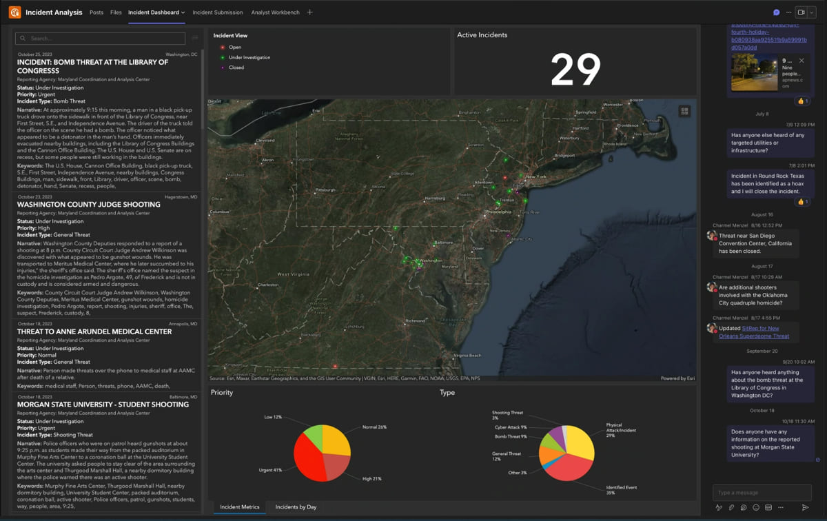
Explaining the method Carl Walter, Esri’s Director of Homeland Security Solutions said in a blog “Cities and counties with real-time crime tracking capabilities connect their data and camera feeds, adding a granular awareness from Real-Time Crime Centers that work with their fusion centers. GIS and other IT staff support the efforts by analyzing data and creating information products to guide decisions.”
Mike Sena, director for the Northern California High-Intensity Drug Trafficking Area (HIDTA) task force, manager of the Northern California Regional Intelligence Center (NCRIC), and president of the National Fusion Center Association (NFCA) is working with the relevant datasets to chart out actionable information.

Sena has been working with Esri’s geospatial tools to visualize potential threat data through maps. “One day we had over 200 threats to schools around the country,” Sena said in a blog. “We never would have seen the scale without visualizing input from nationwide data collectors. People were reporting threats in near real time, and we could see it on the map to figure out the extent of the problem.”
Integrating Esri’s geospatial tools with Microsoft Teams for collaborative threat management enables improved security and risk mitigation through data-driven decision-making and cross-organizational collaboration.
While explaining the importance of Centers, the US Department of Homeland Security stated “The National Network of Fusion Centers (National Network) brings critical context and value to Homeland Security and Law Enforcement that no other federal or local organization can replicate.”.
Fusion Centers accomplish this through sharing information, providing partners with a unique perspective on threats to their state or locality, and being the primary contact between frontline personnel, state and local leadership, and the rest of the Homeland Security Enterprise.
Fusion centers also help in spreading awareness amongst the key stakeholders by educating and informing state and local partners on behaviors and indicators of potential threats, while ensuring the protection of the privacy, civil rights, and civil liberties of individuals and constitutionally protected activities.
CyberSecurity
The initiative of Fusion Centers is beckoning to expand in the current generation where threats are becoming more and more potent via cyber threats, which calls for a larger campaign against terrorism. The future of these fusion centers and their adoption in different countries around the world now remains as the next step.
According to the Cybercrime Magazine’s forecasts, “Cybercrime will cost the world $8 trillion in 2023. If it were measured as a country, then cybercrime would be the world’s third largest economy after the US and China.”
Traditionally, major sectors such as energy, gas, water, and similar primitive necessity-fulfilling areas have been susceptible to most criminal offenses. Rating agency Moody’s has also included the technology industry among the high-risk susceptible areas.
With Fusion centers, the digital footprints of crime can be traced and mapped to easily understand key information such as hotspots, the nature of crime, and to some extent, the reason for it. This data can be further used to predict similar crimes, which would catalyze better readiness amongst safety officials in the country.
“The ultimate goal of a fusion center is to provide a mechanism where law enforcement, public safety, and private partners can come together with a common purpose and improve the ability to safeguard USA and prevent criminal activity. A police officer, firefighter, or building inspector should not have to search for bits of information. They should know to call one particular place-the jurisdiction’s fusion center,” states a US government report.
Results can exhibit the trajectory of Fusion Centers, as is the case with most data aggregators, and its expansion or reduction depends on that result card as well. For defence and safety forces, especially after the 9/11 tragedy, Fusion Centers have been a boon. And as we move towards a more digitally connected world with data at the forefront, Fusion Centers might as well become more prominent.


