
Cardiff, the capital city of Wales, has been experiencing increasing incidents of flooding over the past few years. The frequency and intensity of flooding events have been attributed to climate change, with more intense rainfall and sea-level rise leading to higher water levels in the rivers and coastal areas. In response to this challenge, an aerial map of trees and location intelligence is helping the city to reduce the risk of surface water flooding and support its climate action efforts.
Terrain mapping using Drones
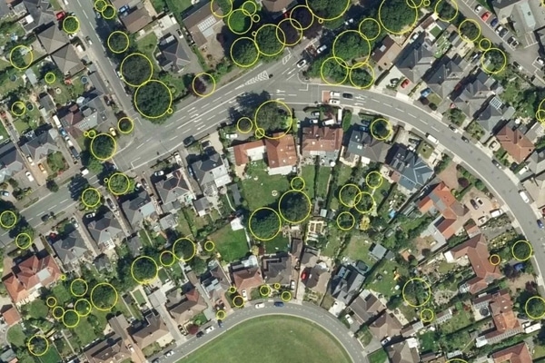
One of the key tools used in Cardiff’s flood management strategy is aerial mapping. The National Tree Map, created by Bluesky International, provides accurate height, location and canopy coverage data for more than 400 million trees across the UK. The map combines algorithms and image processing techniques with aerial photography and terrain data for the whole of Great Britain and Ireland.
Intelligence from the maps, combined with data describing the location of Cardiff’s highways drainage gullies, facilitates cleansing and street sweeping programs, along with community engagement, to be prioritized for areas most at risk of falling leaves blocking drains.
The councilor Caro Wild, cabinet member for climate change said that this was a simple but highly effective way of using location-based intelligence to achieve operational benefits in Cardiff which experiences extreme weather as a result of climate change.
By using GIS, Cardiff can create detailed maps and models of their geography and infrastructure, including their rivers, drainage systems, and flood-prone areas. This allows them to better understand the risks and potential impacts of flooding and develop strategies to mitigate them.
National Tree Map
As part of the national dataset, the Bluesky National Tree Map has captured data of trees three meters and taller in the Cardiff area. Using the open-source geographical information system, QGIS, to compare the proximity of trees and gullies, close to 5,000 or five per cent of gullies or drains (pits covered by an open metal grating) were deemed to be at risk of leaf fall. The Cardiff council has control over around 100,000 highway gullies or drains, which are designed to drain rainwater, and other surface run-off, into a drainage system where it will be conveyed to an appropriate discharge point.
Bluesky data can be used in other applications like planning, drainage and arboriculture. The data can be used for the approval of the SuDS (sustainable drainage systems) which helps in assessment of the impact of trees on watercourses to help prevent flooding. The National Tree Map data also helps arborculturists plan maintenance work for protected trees and inform planting strategies for parks and urban forestry.
Ralph Coleman, sales director at Bluesky commented on how National Tree Map saves time and valuable resources by delivering accurate insights rapidly, and shortening lead times for valuable projects that contribute to the safety and security of the public.


