
Company also wins USD 4.4 million IARPA contract to provide advanced AI for space-based dynamic monitoring
BlackSky Technology and Esri have partnered to release a new cloud-based satellite tasking app that will give Esri users access to BlackSky’s dynamic tasking services through ArcGIS Online. The app, called “BlackSky Tasking for ArcGIS Online, makes satellite tasking directly accessible to millions of ArcGIS Online users for the first time. A user can simply log into their ArcGIS Online account, task a BlackSky satellite on a location of their choice, and have the imagery delivered directly into their accounts. The app is now available in the Esri ArcGIS Marketplace.
“The integration, the first of its kind, will bring the dynamic tasking capability of BlackSky and our constellation directly into ArcGIS Online. So, if you have a subscription to ArcGIS Online and you have a subscription to BlackSky’s Spectra AI platform, you can, within your ArcGIS Online account, task a satellite, have it delivered directly into your account. And this integrates with all of the other information and data that you have for ArcGIS Online,” BlackSky Chief Commercial Officer Amy Minnick told Geospatial World.
Minnick added that the move was an extension of the company’s two-pronged strategy – one, to build its constellation that is able to monitor Earth from dawn to dusk; and second, to do site monitoring for some of the most important locations around the planet for its customers.
In another significant development, BlackSky announced on Thursday (July 14) that it has received a USD 4.4 million award from the Intelligence Advanced Research Projects Activity (IARPA) to support the second phase of the multi-year Space-based Machine Automated Recognition Technique (SMART) Program. “As part of our work, BlackSky created a high-performance MLOps (machine learning operations) framework that was ultimately selected to perform as the core infrastructure to the entire SMART program,” said Patrick O’Neil, the company’s Chief Innovation Officer.
The SMART program aims to automate the quantitative analysis of space-based imagery to perform broad-area searches for natural and man-made events using time-series imagery. BlackSky has developed both supervised and semi-supervised machine learning algorithms to automatically recognize heavy construction projects such as military bases, stadiums, campuses, dams, and airports. With the MLOps framework, BlackSky seeks to extend its Spectra AI tasking and analytics capabilities and accelerate the development of SMART technologies that make quick sense of the immense volume and complexity of space-based image data.
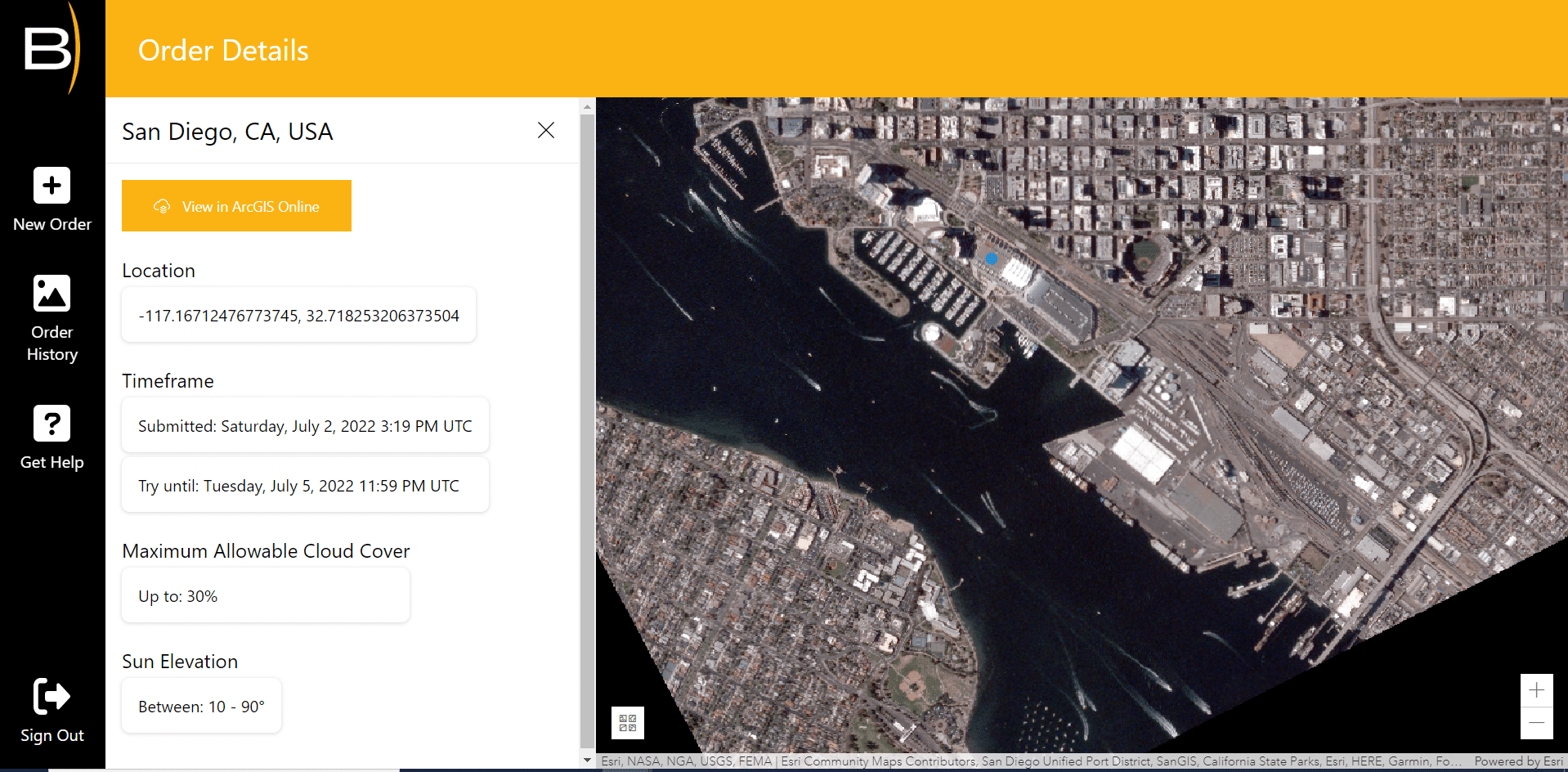
How does the ArcGIS integration work?
BlackSky currently has a constellation of 14 satellites which can be tasked to monitor most locations around the world on an almost hourly basis. Its underlying Spectra AI platform make it possible for users to seamlessly incorporate near real-time imagery into projects without additional processing. The process is fully automated and once images arrive in a customer’s ArcGIS Online account, they can immediately be used in other Esri apps and needs very little training.
“Upon order completion, images arrive within hours and are accessed directly in a user’s ArcGIS Online organization. They can immediately be leveraged using ArcGIS Image for ArcGIS Online to perform analytic workflows that provide analysis for informed decision making,” said Esri Corporate Director of Global Business Development Richard Cooke.
The BlackSky constellation is in a mid-inclination orbit. This means instead of going around the planet at 10 am and just being able to see things at 10 am, with BlackSky, one can just task a satellite from the time the sun goes up to the time the sun goes down. “And that’s important because events happen not only first thing in the morning, but also throughout the course of the day. That is a real differentiation in the way that we’ve built our constellation. And we’ve been working very hard to get to near real-time monitoring with the goal of getting all the way to real-time monitoring over the next couple of years,” Minnick adds.“It’s hourly in most locations in the world; but sometimes, it will be every two hours or so, depending on the location or the availability of the satellites. We are publicly saying that’s about two hours, but it’s very, very quick. If you’re watching a tsunami roll into town, or if you are monitoring a port and you’re trying to get a good… and know when that good is on the ship or when that ship got to dock, that kind of real-time intelligence is really, really important,” she explains.
The Spectra AI platform also brings together a diverse dataset, including SAR data if a user wants to monitor things at night, or track AIS signals of a ship as it leaves a port. However, so far as part of the partnership with Esri, ArcGIS Online users can only task the BlackSky satellites and not have access to this additional diverse data available on the Spectra AI.
“What we’ve announced with Esri is tasking for our own satellites into ArcGIS Online, and that’s the beginning of the integration. We bring those multiple different sources together on our platform, and we can’t do that piece of it right now on the Esri side. But that is something we would like to ultimately move towards. We have got a whole roadmap and plan of what we would do subsequently,” Minnick says.
Why this partnership with Esri?
“As everybody in the industry knows, Esri is the largest provider of GIS software any place in the world. It’s deep in the workflows of commercial customers, in the workflows of civil governments, of national governments. There are more than 300,000 organizations that work with Esri software, which makes it a user base of 10 million customers on a global basis.
That’s exactly the kinds of customers that we want to serve,” Minnick explains.
The partnership enables this huge user base to be able to task satellites and to monitor the locations dynamically as per their requirements.
BlackSky plans to expand such partnerships with other players too in different user markets. “Of course, Esri fits a very distinct and diverse group of end users that are in ArcGIS software. But there are different kinds of companies that are serving end users that are interested in geospatial information, so you’ll see us with subsequent partnerships executing that strategy. It’s core to our strategy of working with great partners that are the best in what they do. And partnering with those entities that can bring our capabilities out to end-users and serve their needs and be able to serve the needs of an increasingly dynamic planet,” she says.


