

Vaibhav Arora
Assistant Editor, Geospatial World
[email protected]

Getting back fast on to the development track post economic recession, UAE is investing in infrastructure, environment and concentrating on diversifying its economy. Here's a deep down look on what's happening on UAE's geospatial scene and the prospects for the industry
The United Arab Emirates (UAE) – the majestic oasis in the middle of a desert – is a visual treat of breathtaking skyscrapers, plush highways crisscrossing each other and some of the most remarkable architectural marvels of the world. But, that is not where the story ends. Development activities are in full swing across and the country plans to take them to the next level. Huge investments have been planned across various emirates in the next few years. All this gives the geospatial industry a mature ground to take off to a point it hasn't reached before.
Although the recent economic slowdown proved to be a dampener for the ambitious plans of various organisations in the UAE, things are slowly but surely getting back on track and geospatial industry is upbeat about the prospects of the increased usage and growth of the technology in the coming years.
The UAE Vision 2021 mandates it to make the country rank amongst the best countries in the world through significant investments in the fields of infrastructure development, environment as well as economic diversification and the geospatial industry is in sync with the efforts presently on to realise that dream. In 2009, the Emirate of Abu Dhabi unveiled its ambitious Economic Vision 2030 that revealed a blueprint for economic diversification. It aims to reduce the country's dependency on oil sector and to focus on other knowledge-based industries, giving the industry another reason to cheer. Another encouraging fact is that apart from Dubai and Abu Dhabi, other cities in the country are also doing appreciable work in this domain.
ECONOMY
The United Arab Emirates is a well developed and fastdiversifying economy, characterised by high per capita GDP of about USD 50,000, one of the highest in the world. The government's constant efforts in achieving greater economic diversification have resulted in a substantial reduction in the share of GDP based on oil and gas to almost 25 percent. There is increased spending on creating more jobs and also more than ever before private sector participation in utilities.
The year 2009 proved to be a chaotic one for world economy and the UAE too felt the impact as its growth rate came down to 7.4 percent as compared to 7.5 percent in 2008. The real effect of the economic downturn was felt in 2010 as the country's real GDP tumbled to -2.7 percent. However, helped by the steadily rising prices of oil and the positive policies implemented by the leadership, the recovery has been pretty swift and a substantial revival is expected by the end of this year. According to IMF estimates, the real GDP growth of the country would be 3.3 in 2011 and 3.8 in 2012.

Figure 1: UAE real GDP growth in the past decade (Source: CIA). The projected figures are as per the International Monetary Fund (IMF)
Cooperation between the emirates was also a major factor that sped up the resurgence process tremendously. In November 2009, soon after the Dubai Government announced that it was seeking an extension on debt payments for the Dubai World, the Abu Dhabi Government stepped in to offer a USD 5 billion loan to help reduce the debt and restore the confidence of international investors.
BUSINESS DRIVERS
Oil and gas sector: The UAE has the sixth largest crude oil reserves and the seventh largest natural gas reserves on the planet. The export of oil was a major reason that had kept the country insulated from the effects of global meltdown during its early phase. Before the recession set in, the sector had witnessed tremendous growth of 35.6 percent in 2008. The sector is deploying latest technology in abundance. According to a report published by CIA (Central Intelligence Agency), the UAE has about 98 billion barrels of oil, which, at the present rate of production, will last for more than 90 years.
Sustainable development: Development of renewable energy is driving the interest of most cities in the country. UAE's Vision 2021 clearly outlines a plan that takes the nation on a path to sustainable development in the future that is less reliant on oil. Estidama, which is the Arabic term for sustainability, is a programme developed by the Abu Dhabi UPC that aims to create a new sustainability framework.
Masdar City, on the outskirts of Abu Dhabi, is a prime example of UAE's commitment to sustainable development. The city is being billed as the world's first zero-carbon and zero-waste city. Geospatial technology is being used extensively to ensure that the city achieves its objective of sustainability during planning, construction and functional phases.
The Environment Agency, Abu Dhabi has the mandate to support sustainable development. The agency is tasked with ensuring that any existing or new industry that is being developed in the Emirate of Abu Dhabi complies with certain environmental guidelines.
Adequate government support: Political leadership in the UAE realises the tremendous potential of geospatial technology and is leaving no stone unturned in ensuring its use in each department and every vertical to improve the services and the overall quality of life. This has resulted in most organisations establishing independent GIS departments. Underlining the importance of GIS division for his organisation, Eng. Ali Ahmed Ghafan, Head of Surveying & Engineering Section, Dubai Land Department says, "GIS department is a part of the survey section and plays an extremely vital role in the organisation's daily work. Almost every inquiry that comes in must go via GIS to be approved."
Yousuf Abdulrahman Almarzooqi, Head of Spatial Data Division, Municipality of Abu Dhabi City further highlights the support from the government saying, "We are very well supported by the government. We have been given complete responsibility and authority to deliver the results." Users too are buoyant and Eng. Yusuf Petiwala, GIS Project Manager, Federal Electricity and Water Authority (FEWA) says, "GIS has helped a lot in the functioning of FEWA. Processes that took two to three weeks to complete earlier can now be finished in just three minutes."
Political stability: Ever since it came into existence in 1971 as a result of the unification of the Trucial States, the United Arab Emirates has enjoyed near perfect political stability. The government's success in maintaining a more than satisfactory record on human rights together with excellent infrastructure, high salaries and a high standard of social services has further minimised the possibility of social unrest and promoted political stability. The country is an active member of numerous world-level associations, which has ensured liberal trade policies and in turn greater foreign investment in the industrial sector, contributing significantly to the economy.
Economic diversification: As the country seeks to limit its reliance on the oil sector, diversification is the keyword for future growth. According to the CIA World Factbook, the country has managed to bring down the contribution of oil sector to the GDP to range between 25-30 percent and aims to further bring it down to less than 20 percent in the next few years by promoting industrialisation. Some of the factors that have so far and will positively contribute to further industrialisation in UAE include mineral resources, easy availability of capital, top-class infrastructure, a liberal labour policy and numerous free trade zones.
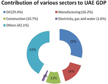
Figure 2: Contribution of various sectors to UAE GDP
Market maturity: Buoyed with government support, various departments are using the technology to improve their functionality and efficiency. Highlighting the fact, John Sasser, President, Rolta Middle East says, "The market is fairly mature in the UAE. Governments are centrally funded and have made significant investments in geospatial technology. The level of technology invested in by the agencies here is at par or more advanced than what one might find in many American or European local agencies."
POTENTIAL VERTICALS
The use of geospatial technology in UAE is spread across various verticals including environment, oil and gas, construction, municipalities, utilities, transport and land management. Predicting the most potential verticals, John Sasser says, "The use of the technology will be universal. There will be some verticals that will rely more on it than others like municipalities or the ministries of transportation. So, geospatial technology will be used in traditional verticals like utilities, military, security, environmental agencies and land management. These agencies are the once that will continue to be heavily in need of a geospatial context to their data."
Figure 3 shows the results of a survey conducted by Geospatial World in which the respondents (consisting of software providers, data providers and other GIS companies) were asked to rate the important verticals on the basis of their GIS potential (on a scale of 10)
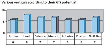
Figure 3: Potential verticals in UAE (Source: Geospatial World)
Construction and infrastructure: In spite of the recent economic slowdown that hit the construction sector in the country, construction remains one area that is a major driver for geospatial industry. A recent report by Business Monitor International projected the infrastructure sector in the country to touch AED 80 billion (USD 21.62 billion) by 2010.
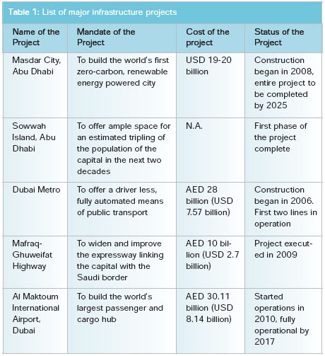
Abu Dhabi's Surface Transport Master Plan, which is a part of the city's Vision 2030, aims to build one of the most comprehensive public transit systems in the world with an investment of over AED 300 billion (USD 81.1 billion) in the next 20 years. A majority of infrastructure projects currently underway have heavy geospatial component and have allocated separate budgets for the implementation of the technology. Table 1 lists the major infrastructure projects in UAE that are utilising geospatial technology.
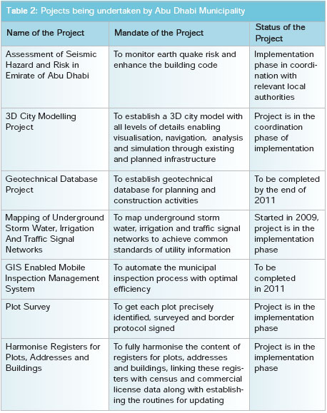
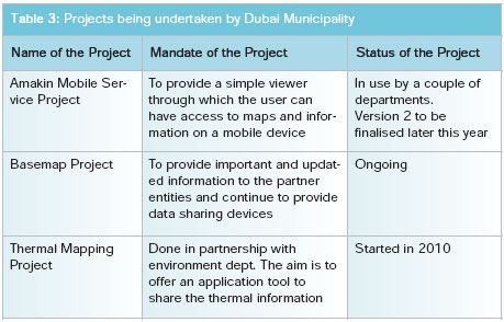
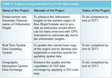
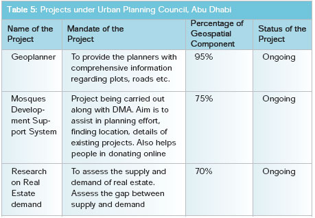
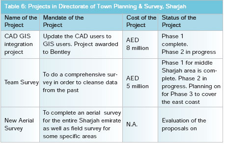
Municipalities and town planning: Urban planning is in focus yet again and city developers have been successful in addressing major areas of concern like traffic jams, housing shortage and the provision of better infrastructure by using geospatial technology. Long term plans have been drawn to improve the overall quality of life. Geospatial technology is acting as a backbone for the functioning of organisations like Abu Dhabi Municipality, Dubai Municipality, Al Ain Municipality, Urban Planning Council (Abu Dhabi) and the Directorate of Town Planning & Survey (Sharjah). Tables 2, 3, 4, 5 and 6 provide details of all the current projects in various phases of implementation in these municipalities.
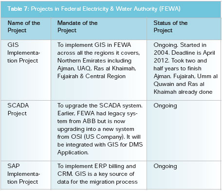
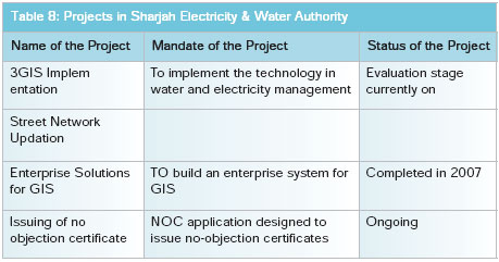
Utilities: A lot of emphasis is being laid on improving various utilities such as water, electricity and telecommunications to enhance the quality of citizens' life. Utility organisations are amongst the most prolific users of geospatial technology and have embedded it in their everyday functioning to improve the overall quality of their services. Faced with the acute shortage of supply and rapidly increasing demand of basic necessities like water and electricity, the government in 2009 signed a contract worth AED 75 billion (USD 20 billion) with a consortium of Korean companies to construct a series of nuclear power plants by 2020 and provide a source of alternate energy. Tables 7 and 8 provide information about various ongoing projects in utilities segment.
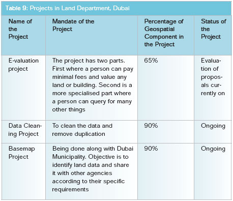
Land management: Land management is one of the most potential verticals for the use of GIS with urban planners, city authorities and cadastral agencies requiring detailed information related to the distribution of land and resources in their bid for better planning and management. The surveying and engineering section at the Dubai Land Department is in the process of automating most of their functions for easy accessibility and quick functioning of all their processes. Table 9 lists out the ongoing projects in Land Department, Dubai.
Defence: Since its inception in 1974, the Military Survey Department, which is a part of the Ministry of Defence, has been acting as a technical support unit for the UAE Armed Forces by providing maps and topographic information.
The department started moving to digital maps in the 1990's, which paved the way for developing applications using the most modern systems and software. The revolutionary change initiated the process of producing necessary spatial infrastructure required for the implementation of geographic information systems.
The progress made by the Military Survey Department during the past few years can be compared with any of the best surveying organisations across the world. The UAE is one of the most prolific investors in the defence sector with almost forty-five percent of its annual budget allocated for defence spending.
Heightened security concerns due to the ongoing political unrest in the Arab world as well as Iran's nuclear ambitions have led to a further increase in arms deals during the past few months. Defence deals worth USD 1.1 billion were awarded to local and international companies during the start of this year and industry experts expect more similar deals in the near future.
Environment: Considering its arid environment, conservation of the environment is perhaps one of the most difficult tasks the country is faced with. However, the government has accepted the task as a challenge and efforts are on to strike a balance between development and environment protection.
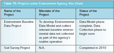
The Environment Agency Abu Dhabi, which is responsible for almost four-fifths of the country's total land area, has been extensively using geospatial technology since the mid-90s and is working closely with the authorities to make sure that the region successfully accomplishes its goals as outlined in its 2030 Plan. The Al Gharbia 2030 plan, which is a part of the Abu Dhabi vision, proposes to convert several thousand kilometres of desert into nature reserves. Any future development in the area will be monitored strictly.
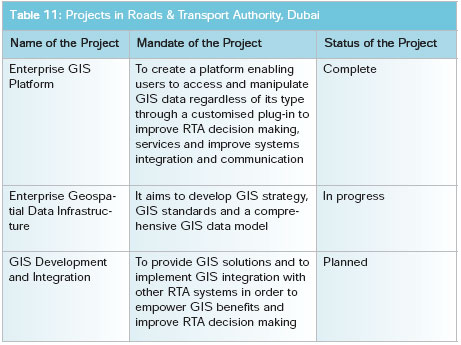
Transportation: The GIS section in the Roads and Transport Authority, Dubai, was established in 2009 and has the mandate to improve the overall quality of its services by providing up-to-date spatial information leading to integrated GIS solutions which enhance decision making. GIS has been a vital cog in the state-of-the-art facilities offered by Roads and Transport Authority, be it the fleet of GPS equipped buses and taxis or the driver less Dubai Metro. Table 11 lists out the ongoing geospatial projects in Roads and Transport Authority, Dubai.
The Middle East region is projected to invest close to USD 80 billion in building new transport infrastructure over the next 10 years and a bulk of the investment will be made by cities like Abu Dhabi and Dubai.
WAY AHEAD
Regional cooperation: Although there is tremendous potential for the utilisation of geospatial technology in the Middle East, regional cooperation is still an issue that needs to be addressed, feel industry players. The region still has a long way to go when it comes to cooperation at the regional level, particularly in some of the areas such as environment. It is extremely important to understand the global and regional perspective to effectively tackle challenges at the local level.
Data availability: Data is at the core of geospatial deployment and availability and accessibility of data is still a challenge in UAE. The Abu Dhabi Spatial Data Infrastructure (AD-SDI), under the aegis of Abu Dhabi Systems & Information Centre (ADSIC), has put in great efforts in making data easily available to the users.
Naeema Al Zarouni, GIS Manager, Abu Dhabi Urban Planning Council says, "Yes there are certain issues in data access. While most of the entities share data on a service level agreement, there are certain entities that are still having some issues and cost associated with providing the data."
"A negative aspect of the functioning of ADSIC is that sometimes we are not allowed to purchase our own data as the government does not want duplication of data which adds to the costs. However, the problem is that for planning purposes, we need frequently updated data on a regular basis, which is not always available," says a respondent who did not wish to be quoted.
Another problem is the compatibility of data that is made available. "The data that we are getting is incomplete most of the time because geospatial technology is still new for some organisations. It often becomes difficult to find good and clean data. It becomes a difficult task to map our assets on different data sets, especially when it is changing constantly," says Eng. Yusuf Petiwala.
Capacity building: Another major challenge for the country is the availability of human resources. The availability of Arab speaking professionals is limited. Though the situation is improving, the gap is wide to be filled up in the near future. Highlighting the difficulties faced in upgrading the available resources, Eng. Ghafan says, "The availability of resources is a huge problem. Technology keeps changing rapidly so you have to constantly upgrade your resources or hire new people or contract with outside agencies. Doing that has its own share of problems."
TO CONCLUDE
Although the geospatial market in the United Arab Emirates is full of potential and is set for a leap onto the next level, the need of the hour is to educate the end users about the tremendous benefits associated with using this technology. The country is coming out of the effects of recession and is on its way to reclaim its position as an economic powerhouse. The ambitious plans marked out in the Vision 2021 exhibit the Emirati peoples' desire to match step with the world and can be accomplished by developing the right kind of resources.


