There is a growing interest in commercial space-based radio frequency (RF) data. A tightly controlled sector till recently, this growth has resulted in a new era of GEOINT data in terms of how all this new information fits into the mission space or how it could be fused with other information sources.

“It’s been great to see the GEOINT community embracing RF. With RF, you are able to characterize the environment, understand if there is GPS jamming going on in the domain, and you can actually apply geo location techniques,” says Conor Brown, Federal Director of Sales Engineering, Spire Global in an exclusive interview with Geospatial World.
Brown feels the conflict in Ukraine has seen, perhaps for the first time, a flood in commercial imagery, actually giving us real-time information. “It has been incredible to see the commercial space industry be in the forefront of the intelligence in these situations. Every day there’s another image and that data is being shared within the hour for a lot of these providers.”
Excerpts
Tell us about your satellite offerings and their applications?
The reach and unique data collected by our satellites has a diverse range of applications from meteorology and weather forecasting, scientific investigation into oceanography and other scientific studies, tracking global challenges related to population growth, resource management or climate change.
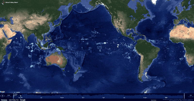
Space-based RF data and analytics is proving extremely valuable for maritime domain awareness. Spire collects a lot of RF imagery in different frequency bands that collect different signals of interest. A lot of our signals cover the maritime domain. Many a times when a maritime vessel goes dark or stops transmitting AIS signal, there will be other transmission. Typically, they are still communicating somehow, and those can be those mobile handsets or hotspots. That’s a similar frequency band to where we collect now.
ALSO READ: Adoption of 4IR Technology Revolutionizing GeoInt
Our work is complimentary to what we’ve done with our GPS and GNSS monitoring. We’re able to collect signals of interest to detect evidence of interference in those bands or nefarious activity, trying to cause interference. That’s where we are in the RF space.
How does satellite based RF monitoring work?
The RF spectrum is well defined and well regulated. AIS (Automatic Identification System) transmits over a specific frequency on the lower end. For all these different types of emitters, whether it’s your cell phone or it’s an AIS signal coming off a ship, there are very select frequencies that you are authorized to operate within the radio frequency spectrum.
We have a single satellite geolocation technique to approximate the location of that source emission of the frequency. We then work with partners or providers or other system providers such as SAR, multispectral or optical imagery to use that to task those systems. If we know there’s a certain behavior going on in an area, we can look at what data we have and try correlating the times and understanding if we can get the next-level intelligence on that emitter. Then we can deliver a solution or a service to our customer base. This has been tremendously helpful for finding new collaborations from the SAR or imagery providers.
Ships at sea get their position from GPS and then they transmit that in an AIS signal over VHF, which we collect — but that’s cooperative signals. There’s also uncooperative signals like a GPS jammer, where it’s just putting a high energy in the GPS spectrum. Some jammers are more sophisticated where they will have fake GPS signals to make you think you are somewhere when you are not. Others are less sophisticated, and they are just high power, so your phone, ship, or tactical equipment can’t tell you where you are.
At Spire, we can detect the external characteristics of a jamming signal, where we can determine if the emitter has the peak right at the GPS center frequency and if that’s going to deny position and timing services for the users in that domain. Then we can do some additional signal processing and analytics to find out if there was a false GPS signals being broadcast.
There are 32 GPS satellites with PRN (pseudo random noise) codes. In case of false signals, you can actually see the signals collected show all 32 GPS satellite PRNs. Then, we know that’s impossible because two thirds of them are on the other side of the earth. So, you know there’s some nefarious activity going on.
We’re able to also perform geolocation of those jammers to know approximately where they are. That’s really interesting intelligence because you can’t see any of that and can’t pick any of that up and SAR or spectral data. So, this is where satellite-based RF monitoring becomes important.
As we launch more and more satellites, we are expanding our capabilities to collect more spectrum.
But ultimately, you have to lay it on another set of imagery to see where exactly it is happening?
It all depends on the use case and what the user really wants. Let’s use the example of a dark vessel that’s broadcasting an AIS message and then it wants to do something illicit. It’ll turn that off, so you no longer track that vessel through traditional means. It’s no longer reporting its position, but then we can tell through other emissions that there is something there. There are no islands in the region, so you know something’s afloat at sea and there’s a human operating a radio frequency transmitter.
If we have a track of an open vessel at sea, and then it just stops, we know we have collectors and we have confidence of reception algorithms. If it’s there, it’s legally obligated to transmit. If we can no longer collect a signal, we can start to collect in other radio frequency signals such as satcom emissions, Iridium, Globalstar, Thuraya. We can look at push to talk radios, where there are other signals that vessels emit like maritime radars and things like that operate in different frequency bands. If you do collect some of that, and then you can apply geolocation techniques to locate approximately where it is. You can then marry that info with the previous data you had and then layer on imagery.
And if you can get an image, see a vessel, and know there’s no AIS, but there is a ship? That’s validating for the analysts.
ALSO READ: GeoInt, OSINT Comes Off Age For Near Real Time Coverage of Ukraine Conflict
We have worked with Ursa Space where they take our maritime data, then they marry that with imagery to try to find and detect those dark illicit vessels. So that’s just one common use case. The maritime domain is compelling because it’s a difficult problem to solve. Historically, it has been really challenging to track this activity on the open ocean, because it’s just hard to monitor; that’s where satellites are so beneficial.
We have also collaborated quite closely with the commercial imagery providers like Planet, for example, to marry our maritime data with their imagery from their constellation of satellites. ICEYE was one of the original ones we looked at for dock shipping.
Once you have identified a bad actor, how does it work out?
We share the information with the government agencies or the authorities that are in-charge of regulating and understanding the environment. There are all sorts of different government entities that want that intelligence so that they can take action.
It’s great to see the governments adopting commercial data and ingesting it into existing tools they have. Government agencies have historically bought a lot of imagery data and so now we are working with them to figure out how to ingest the RF data to create a common operating picture.
Then analysts can be trained and understand how to work with all these different sources of information to get to the truth.
That’s where a lot of our partners can do the analytics. I mentioned Ursa already, but there are other partners, and we have our own tools as well. If a vessel is reporting its position somewhere, we have algorithms based on the messages received to check that. There could be different causes for a misreport — for instance a faulty GPS receiver on the vessel — which is not always illegal activity. Then, again, it could also be that they’re trying to throw it off the scent for authorities.
Do you have some interesting in Ukraine that you observed?
What we have been doing with the Ukraine situation is really putting resources into monitoring the impact to global trade, when all the ports were shut.
All the Russian tankers were not allowed, and the sanctions were rolling out. We’ve been providing that data to news outlets etc. Jamming wise, we haven’t specifically shared anything on the activity over there, but we have been using the AIS data and the spoofing data to track certain tankers that are owned by Russia that we believe are trying to avoid sanctions by doing ship to ship transfers without AIS on.
Sometimes when these tankers meet, they turn on the AIS, and and then we can find out who they are because AIS is a vessel identifier, like license plates for cars. We can follow the signals associated with the ship, and we can follow that tanker wherever it goes.
Interestingly, we’ve also seen an uptake in AIS activity in a port in North Korea in recent times, which is really interesting because usually North Korea is a complete dark spot.