Home 2023 November 7

Daily Archives: 11/07/2023

Location Insights with Generative AI: How LLMs Simplify Geospatial Intelligence

Location Insights with Generative AI: How LLMs Simplify Geospatial Intelligence

In an increasingly data-centric world, geospatial data has emerged as a pivotal player in helping us unravel the intricacies of our environment and make well-informed decisions. This treasure trove of information guides us in tracking everything from the movements of people and goods to the rapid spread of natural disasters. However, traditional methods of dissecting geospatial data can often prove to be intricate and time-consuming.

Relevance of Generative AI in Digital Era

Enter Generative AI, a groundbreaking technology that is reshaping the way we approach geospatial data analysis. Generative AI models possess the extraordinary ability to generate entirely new data, encompassing maps, images, and text, all based on existing datasets. This innovative approach dramatically streamlines the process of analyzing geospatial data, uncovering hidden insights that were once obscured.

In the webinar, Hari Subhash, Director of Community, Content Strategy, and Enablement at Kinetica, talks about the Large Language Models (LLMs) and how they are deployed in geospatial data analysis. LLMs are a category of artificial intelligence models capable of generating text, performing language translation, crafting creative content, and providing informative answers to your queries.

In today’s scenario, he talked about how there is a big lag in data analytics today especially when in response to a query. The response to a query can take days when with Kinetica it will only take seconds to respond to a query.

Why Kinetica then?

Kinetica is a real time engine that can power conversations with your data. It is built for workloads at petabyte scale. It is 8x faster than Databricks, 13x faster than Clickhouse and 240x faster than Post-GIS.

It has in data functions which enable analytical enquiry. It has 150+ spatial functions modeled after the ST function library from Post GIS. Kinetica is focusing on having the database have a deep integration with generative AI.

The developer edition comes free which requires docker for installation. There is also a shared fully managed cluster in the cloud with 10GB of Space. Kinetical also provides a set Kinetica examples repo that is actually collection of sample workbooks that showcase different features.

Kinetica’s advanced Generative AI capabilities can simplify the formulation of sophisticated geospatial algorithms, even when dealing with massive datasets.

Through this, Large Language Models (LLMs) can now promptly generate complex geo-joins, ST_Geometry functions, and geo-graph solvers. It can create maps and images from geospatial data and conduct geospatial queries using natural language.

All this can be achieved by simply expressing a question in plain English and executing the operations within mere seconds. Potential risks and threats can be identified and geospatial data can be used to discern trends and patterns. The potential of Generative AI is immense it’s reshaping the landscape of geospatial data analysis.

Seoul Robotics Partners with Austrian Company for European Roadways Safety

0
Seoul Robotics Partners with Austrian Company for European Roadways Safety

Seoul Robotics announced a partnership with ALP.Lab to provide 3D perception traffic safety systems for the DACH region and Central Europe.

The LiDAR systems provide detailed insights into accident-prone intersections and are currently being deployed in Salzburg, Austria.

The European Union (EU) has set a goal of reducing overall road deaths to zero by 2050. Progress has been made across Europe however, the number of bicycle crashes has remained consistently high with it being the only mode of transport that has not declined in fatalities over the past decade.

Cyclists have had the greatest increase in serious crash-related injuries at 24%, with a high proportion of cyclist fatalities occurring at intersections. In order to achieve the EU’s goal and save lives, Seoul Robotics and ALP.Lab developed a LiDAR-based system, powered by Seoul Robotics’ perception software, SENSR™,  to better understand interactions between vulnerable road users and vehicles.

Salzburg Research deployed the solution in cooperation with the Mobility Laboratory zukunftswege.at after identifying two high-risk intersections with multiple bicycle lanes in the city of Salzburg. The solution was designed to collect and analyze precise and high-frequency data of all road user movements and specific and complex interactions between vehicles and vulnerable road users.

“Based on the comprehensive data gained, we can analyze road user behavior and conflict situations and derive valuable insights, which generally contribute to an increase in road safety for all road users and specifically enable improvement measures at the analyzed intersection,” said Siegfried Reich, Managing Director at Salzburg Research.

Access to the infrastructure at the intersections was very easily established via the zukunftswege.at mobility laboratory. “With the help of our real-world laboratory environment, results from the tests can be passed on directly to the city and state of Salzburg as the responsible regional authorities,” said Christian Kainz, Project Manager of the mobility laboratory zukunftswege.at.

“Road design plays an enormous role in user safety and until recently, there’s been very limited quality data that can decipher the chaos and show us where we need to improve,” said Christoph Knauder, Manager Operations at ALP.Lab. “This is especially true for cyclists which are a major pain point in Europe’s mission towards zero road deaths by 2050. We’re excited to grow our partnership with Seoul Robotics so that more cities across Europe can get the insights they need to build smarter, safer roads.”

Each Salzburg intersection has been equipped with four sensors and a LiDAR-Processing Unit running Seoul Robotics’ perception software. This software, SENSR, collects data from strategically positioned sensors for insights into the position and speed of objects within the intersection and is uniquely able to differentiate between cyclists, pedestrians, and vehicles in order to simultaneously and anonymously analyze their movements.

“Improving safety for cyclists and pedestrians not only reduces road fatalities, but also encourages active mobility which reduces congestion, emissions, and generally leads to a healthier population,” said William Muller, Vice President of Business Development at Seoul Robotics. “Together with ALP.Lab, we’re helping Salzburg create a blueprint for mobility solutions and generating huge amounts of quality data for further custom processing and smart city applications.”

SENSR’s industry-leading deep learning AI uses non-biometric data to accurately detect, track, and classify hundreds of street-level objects, even in harsh weather conditions. The 3D perception software is sensor agnostic and able to seamlessly fuse multiple LiDAR makes and models to get a full picture of the intersection and the connecting roads in one field of view. When deployed, the technology records high-quality data that will be utilized for unprecedented analytics.

Through this partnership with ALP.Lab, Seoul Robotics-powered solutions will soon expand across Austria, and into Germany, Switzerland, and the broader Central Europe region.

Geospatial Infrastructure Powering Global Transition

Geospatial Infrastructure Powering Global Transition

At the GeoGov Summit 2023, Sanjay Kumar, CEO, Geospatial World delivers the welcome address on the theme ‘Advancing Geospatial Infrastructure in Partnership to Meet Nation’s Needs’. He says, “The power of geospatial infrastructure is very critical and it is driving the global transition. Geopolitics of technology transfer is the driver of technology trait. The public policies, or the international relation, or the alignment today is what the world is going through and this I call “the elasticity of world order”.

EUSI & Pixxel Partner to Bring the World’s Best Hyperspectral Imagery to European Market

0
EUSI & Pixxel Partner to Bring the World’s Best Hyperspectral Imagery to European Market

European Space Imaging (EUSI), a provider of Very High Resolution (VHR) satellite imagery and Pixxel, a leader in cutting-edge hyperspectral earth-imaging technology have announced a strategic partnership today.

Under this partnership, users will have unparalleled access to the world’s most detailed hyperspectral imagery from Pixxel directly through EUSI. Combined with EUSI’s capability to build insights and products, the partnership is poised to set a new benchmark in remote sensing applications in the region.

The ever-expanding offering from EUSI solidifies its position as a hub for EO data in the region. With this collaboration, customers can now acquire Pixxel’s hyperspectral dataset in addition to world-leading optical and SAR imagery, all from one single source.

“High-quality hyperspectral imagery has been an elusive dataset within the Earth Observation community, and therefore, the opportunities to drastically impact industries across the globe are yet to be realized,” said Adrian Zevenbergen, CEO of European Space Imaging. “Pixxel’s innovative technology is filling this gap and EUSI is proud to partner with them to help bring the benefits of hyperspectral data to the market and demonstrate our commitment to Europe’s agriculture and energy production goals through the use of remote sensing.”

“We are thrilled to partner with EUSI to realise Pixxel’s vision of building a health monitor for the planet”, said Awais Ahmed, co-founder and CEO of Pixxel. “EUSI’s confidence in our technology and their rock solid reputation and track record will be instrumental in helping us expand our footprint across Europe and North Africa.”

Capturing up to 250 bands at 5m resolution with a daily revisit, the unique features of Pixxel’s sensors power meaningful change detection across the agriculture, forestry, energy and mining sectors. The sensor characteristics combined with flexible tasking, simplified pricing, and a highly tunable band set selection are what will truly distinguish Pixxel’s offering for EUSI customers.

“We are keen to collaborate with EUSI’s in-house geospatial experts and their deep network of resellers across the EU to catalyze the education and adoption of hyperspectral data,” said Aakash Parekh, Chief Commercial Officer, Pixxel. “Hyperspectral is particularly valuable in its ability to identify species, detect greenhouse gas emissions and measure above-ground biomass and we look forward to bringing these solutions to EU enterprises and governments through this partnership.”

Pixxel has raised US$71 million to date and has 50+ early adopter customers globally. With already three hyperspectral satellites in space, Pixxel is now working towards launching 6 satellites in 2024 and 18 further satellites by 2025, aiming to build a comprehensive health monitor for the planet.

ESA and EC to Unite on Climate Action From Space

0
ESA and EC to Unite on Climate Action From Space

ESA and the European Commission are joining forces to accelerate the use of Earth-observing satellites and the information they provide to address the pressing challenge of climate change.

This landmark initiative signifies a firm commitment to advancing our understanding of Earth’s climate system and enhancing our ability to take timely and informed actions to mitigate and adapt to the impacts of climate change, particularly encompassing the European Green Deal.

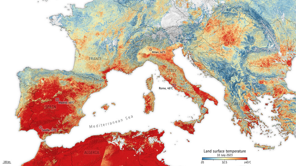
Heatwave across Europe

The climate crisis is arguably the greatest global challenge we face today, with far-reaching consequences for our planet’s ecosystems, economies and societies.

As world leaders grapple with the urgency of climate action, the role of space-based technology and data has become increasingly critical.

Access to actionable information is fundamental to fight climate change, to support knowledge-based policies and initiatives and their implementation, and to ensure that this is balanced with sustainable economic development and societal benefits.

ESA and the Commission’s Directorate-General for Climate Action (CLIMA) are, therefore, seizing the opportunity to harness their combined expertise and resources to bring about transformative change, not least in the context of the EU’s Copernicus space programme and ESA’s Space for a Green Future Accelerator.

Space for a Green Future

Earth-observing satellites and the data they provide already offer the tools and solutions to effectively support, understand, monitor, mitigate and adapt to climate change.

Through Europe’s Copernicus programme, satellites deliver systematic data for a multitude of everyday services that benefit society in many ways.

Here, services include the Climate Change Service. It supports adaptation and mitigation policies of the European Union by providing consistent and authoritative information about climate change.

Its primary objective is to help the European Union achieve its ambitious goal of becoming the world’s first climate-neutral continent by 2050, as laid out in the European Green Deal.

Multidecadal satellite datasets compiled through ESA’s Climate Change Initiative underpin Essential Climate Variables to support the United Nations Framework Convention on Climate Change, and provide an impartial yardstick to understand climate processes and identify the impacts of change.

Key components of the climate system

In addition, ESA’s FutureEO programme harnesses novel ideas to develop pioneering satellite missions and concepts, nurturing imaginative new ways of using Earth observation that enable scientific excellence to flourish and address the environmental challenges of tomorrow.

While both ESA and the European Union are already actively addressing the climate crisis, more can be done, particularly by better exploiting the transition that the space sector is currently experiencing.

To this end, ESA and CLIMA are reinforcing their cooperation by working together even more closely and looking into more opportunities to use space-based solutions for climate mitigation and adaptation.

This includes, for example, exploring better monitoring, reporting and verification solutions for greenhouse gas emissions, deforestation, detecting methane leaks, identifying specific legislation that could benefit from Earth observation data, helping to identify site locations for renewable energy plants.

The initiative also supports the development of tailormade tools, such as the Green Transition Information Factory, and furthering the European Union’s Land Use, Land Use Change and Forestry Regulation.

Faenza flood map
Faenza flood map

Furthermore, the initiative will seek to assist industries and public organisations from multiple sectors to assess risks and implement decarbonisation strategies.

ESA’s Director General, Josef Aschbacher, said, “The climate crisis is upon us, and we have to act fast and act together for the benefit of Europe and, indeed, the world.

“Through this new initiative, together we will develop a structured cooperation that paves the way for information-sharing, mutual consultations and joint plans.

“Exploiting the complementarity between our respective programmes, together we will advance climate science, support policy implementation and boost green innovation on the road to the European Green Deal and a carbon-neutral future.”

Uniting on climate action from space

The European Commission’s Director General for Climate Action, Kurt Vandenberghe, added, “Space, and in particular Earth observation, offers a unique perspective on how to tackle climate challenges faced by humanity.

“Space technologies are crucial for reaching climate neutrality and climate resilience by 2050. Through our joint initiative, we are committed to exploring and enhancing opportunities for the development and broader implementation of space-based solutions dedicated to climate action.”

Geo Week Announces Sneak Peek of 2024 Keynote Lineup

0
Geo Week Announces Sneak Peek of 2024 Keynote Lineup

Geo Week

Organizers of Geo Week, the premier event that champions the coming together of geospatial technologies and the built world, have released a preview of their keynote sessions: The Bright Future Ahead: Navigating AEC, 3D, and Geospatial Innovation and Change and Geospatial for Good: How is Geospatial Technology Changing the World? The 2024 edition of Geo Week takes place February 11-13 in Denver, CO.

“Keynotes set the tone for an entire event, and this year’s topics and speakers are doing so in ways that will resonate across the geospatial and built world industries,” said Lee Corkhill, Event Director at Diversified Communications.

“Sunday’s keynote is all about looking towards the future, emerging technologies, and workforce development, while Monday’s keynote is focused on how geospatial technology is currently addressing critical problems in climate change, sustainability issues, disaster response, public health, and social justice. This combination will help attendees understand how to take the next step to use geospatial technology to better our world.”

Sunday’s keynote, The Bright Future Ahead: Navigating AEC, 3D, and Geospatial Innovation and Change, will be lead by Claire Rutkowski, SVP and CIO Champion at Bentley Systems, and include panelists Andrea Springer, VP of Digital Technology & Innovation at Stantec, and Ben Stocker, Construction Technologist at Skender, with more panelists to be announced. The keynote will discuss emerging technologies, including generative AI, large language models, augmented reality, and how digital twins are already impacting day-to-day work in surveying, AEC, and other industries. While some of those technologies are still in their early stages of adoption, keynotes will focus on what’s coming next and what workflows look like in 2030. This visionary panel will share their predictions, cautions, and enthusiasm about what’s next, including a look at today’s workforce and how it can be prepared for the seismic shifts ahead.

Monday’s keynote, Geospatial for Good: How is Geospatial Technology Changing the World? features insights from Este Geraghty, Chief Medical Officer and Health Solutions Director at ESRI, with an additional speaker to be announced. Through the development of technologies and techniques, including lidar, GIS, bathymetry, photogrammetry, AI, and beyond, geospatial knowledge is being applied across disciplines to help address many critical problems. In this keynote, technology thought leaders will share their visions of how geospatial technology is already being used to make a difference in addressing climate change, sustainability issues, disaster response, public health, and social justice, and discuss how the geospatial community can get involved.

“Both of these keynotes will shine a light on the future – from the benefits of geospatial technology to the future of work,” said Carla Lauter, Conference Chair and Editorial Analyst for Geo Week. “With the rapid pace of change across myriad industries, shining a critical spotlight on the road ahead is more important than ever.”

Geo Week also features vendor-delivered Product Previews, Exhibit Hall Theater presentations, and workshops, in addition to an Academic Hub, multiple networking events, and the Geo Week Awards Celebration. More than 151 solutions providers have confirmed booths on the Exhibit Hall Floor with additional companies being confirmed every week. More than 150 associations and media partners are confirmed as supporters.

Geo Week provides education, technology, and resources for professionals in industries including AEC, Asset & Facility Management, Disaster & Emergency Response, Earth Observation & Satellite Applications, Energy & Utilities, Infrastructure & Transportation, Land & Natural Resource Management, Mining & Aggregates, Surveying & Mapping, and Urban Planning & Smart Cities.

Krishi 24/7, the First-Ever AI Solution for Automated Agricultural News Monitoring

0
Krishi 24/7, the First-Ever AI Solution for Automated Agricultural News Monitoring

Department of Agriculture and Farmers Welfare (DA&FW) in collaboration with Wadhwani Institute for Artificial Intelligence (Wadhwani AI) developed Krishi 24/7, the first-ever AI-powered solution for automated agricultural news monitoring and analysis, with support from Google.org.

Krishi 24/7 will aid DA&FW in identifying relevant news, generating timely alerts, and taking prompt action to protect farmers’ interests and promote sustainable agricultural growth through improved decision-making.

The introduction of Krishi 24/7 addresses the need for an efficient mechanism to identify and manage agricultural news articles of interest to aid timely decision-making. The tool scans news articles in multiple languages and translates them into English.

It extracts essential information from news articles, such as headline, crop name, event type, date, location, severity, summary, and source link, ensuring that the ministry receives timely updates on relevant events published on the web.

Launching the initiative, Secretary (A&FW) Shri Manoj Ahuja said that this news monitoring system will not just keep us informed but empower us to shape the narrative. In the spirit of continuous improvement, he further suggested that we remain open to enhancing this system as we move forward.

As the world evolves, so should our tools and methods. Let us work together to ensure that this news monitoring system becomes a dynamic force, adaptable to the changing landscape of information, and a valuable asset in our mission to better serve our farmers.

Multi Modal Connectivity to Boost Indian Economy

Multi Modal Connectivity to Boost Indian Economy

Multi Modal Connectivity to Boost Indian Economy

Picture of By Jeffy Jacob
By Jeffy Jacob

Sub Editor | Geospatial World

"You and I come by road or rail, but economists travel on infrastructure"
~ Margaret Thatcher ~

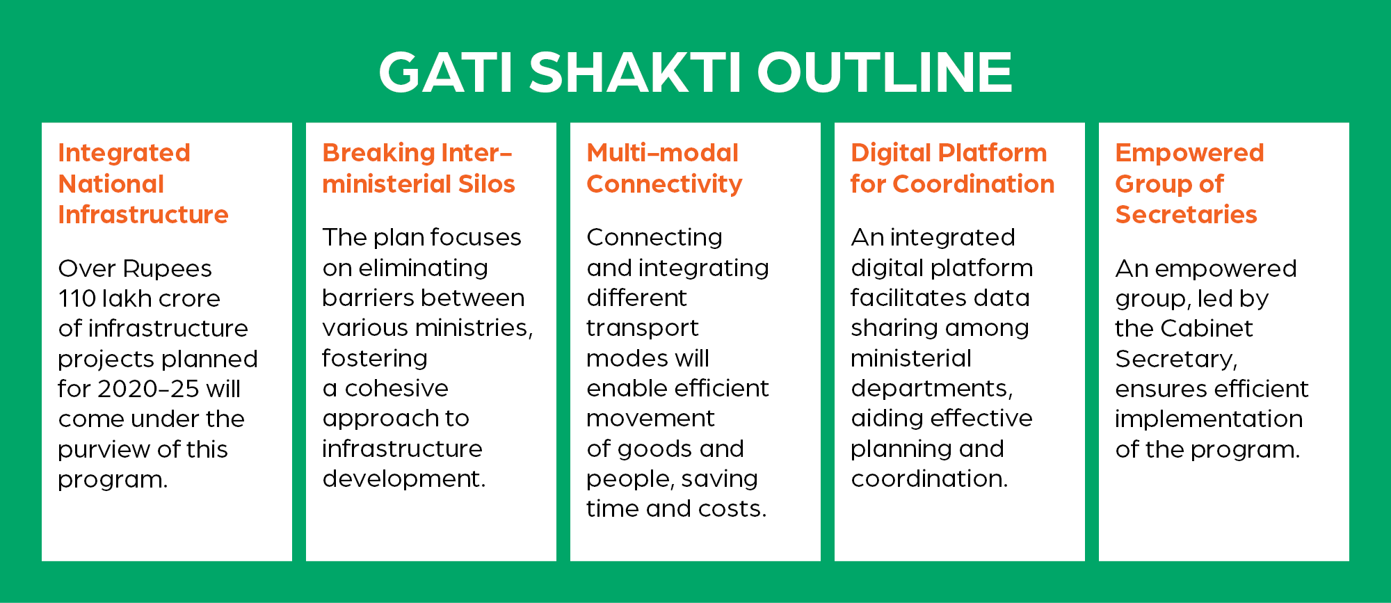
India’s stride towards infra development is often impeded by myriad challenges and complexities that arise due to a host of factors and at times the mismatch between the pace of ambition and reality.

A CAG report, released in August this year, flagged the excessively high construction cost of the 30km Dwarka Expressway, part of Phase-1 of the Bharatmala Programme for building national highways in the country, highlighting that the high cost was due to a number of factors, including the use of expensive materials, the need for extensive land acquisition, and the complexity of the construction work.

The 14-lane expressway, which includes an eight-lane elevated road, is expected to be fully completed by January 2024. The Dwarka Expressway was being built at a cost of Rs250.77 crore per kilometre as against the Union Cabinet approved cost of Rs18.20 crore, which has now been refuted by the Road Ministry. The report also noted that the MoRTH did not adequately justify the high cost of the project and that there was a lack of transparency in the bidding process. The government needs to put in place strong safeguards to prevent this from happening.

Inadequate planning, insufficient investment, and underutilization of cutting-edge tech are some of the common travails. The world’s largest country would require optimization of processes across the project lifecycle, and prioritization of tech adoption.

As India charts a course towards the ambitious target of attaining a $5 trillion GDP by the fiscal year 2025, the road to economic zenith demands approximately $1.4 trillion, according to Eco Survey.

“Infrastructure serves as the cornerstone of India’s ambitious vision to achieve a five trillion-dollar economy. While we are currently forging ahead, constructing new roads and bridges, we cannot overlook the pressing issue of our ageing and deteriorating existing infrastructure”
Shri Nitin Gadkari
Minister for Road Transport and Highways

“The protracted decision-making processes within our system have become a significant hurdle, often leading to delays of two to three months”, he added.

Candidly acknowledging that silos exist, he said that Digital Twin can come to the rescue. The PM Gatishakti Initiative has effectively brought together various ministries to collaboratively develop infrastructure in a synchronized manner. This approach aims to address the country’s needs and the various Economic Development zones systematically.

“PM Gati Shakti enhances efficient connectivity, enabling the achievement of the targets set by the National Infrastructure Pipeline, which encompasses infrastructure development exceeding 1.8 trillion dollars by 2025”
Amit Kumar Ghosh
Additional Secretary, Ministry of Road Transport and Highways (MoRTH)

In this context, the next step should be the adoption of digital twin which has the potential to transform the infrastructure sector. Fortunately, digital twin is a field where there are currently no clear-cut global leaders presenting an opportunity for India to take a pioneering role on the world stage, he emphasized.

“Gatishakti also aims to ensure seamless coordination and collaboration among all stakeholders, enabling everyone to operate from a shared foundation of accurate, real-time data. This, in turn, empowers informed decision-making at every level.”

Better Planning

Poor planning has resulted in India’s infrastructure being woefully inadequate in the past. Projects have often been delayed or cancelled due to insufficient planning. An example would be the scrapping of the planned metro stations in Chennai. India has not fully utilized the latest technological resources to improve its infrastructure.

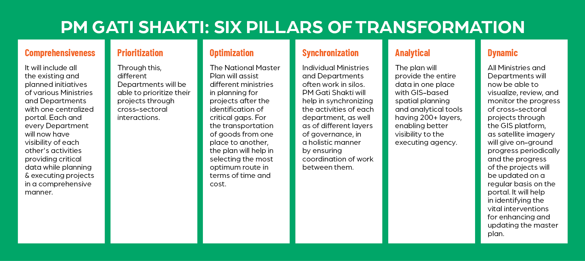
“What sets PM Gatishakti apart is its adoption of scientific planning, bolstered by digital technologies and a GIS-based National Master Plan. With this approach, we gain the ability to visualize the intersections of various GIS layers, including infrastructure assets, natural resources, forested areas, and social assets,”
Sumita Dawra
Special Secretary (Logistics) DPIIT.

It’s crucial to understand that improved infrastructure planning isn’t solely about connecting manufacturing centers to ports, roads, or airports for the ease of doing business; it’s also about enhancing the quality of life. Remote areas, for instance, may require better connectivity to schools and Anganwadi centers. PM Gati Shakti plays a pivotal role in improving the ease of living, she added.

“A significant issue revolves around the lack of substantial investments or sufficient allocation of public funds. These challenges converge into the realm of project governance and infrastructure planning,”
Dr. Surendra Ahirwar
Joint Secretary, Logistics & Trade, Ministry of Commerce & Industry

He believes that the way forward is via evaluating the existing infrastructure deficit, procuring funds from private or public sources for infrastructure development, embracing appropriate technologies, and ensuring efficient planning.

Spatial Kernel

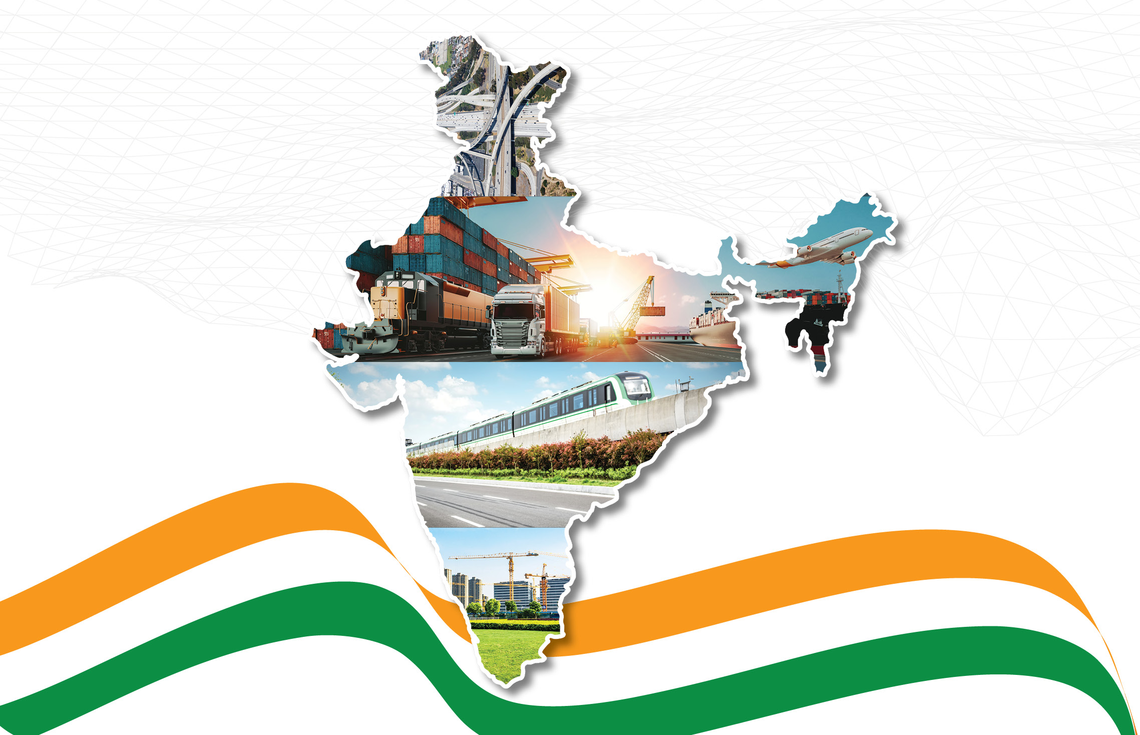
In 2021, India’s Prime Minister, Shri Narendra Modi unveiled a blueprint that aims to address this infrastructural inertia. At its core, the National Master Plan seamlessly integrates roads, railways, airways, waterways, and logistics—a multi-modal marvel.

The ambitious master plan places geospatial technology at its core. The adoption of a Geographical Information System (GIS) platform has proven instrumental in consolidating data related to physical assets, demographics, socioeconomic aspects, and geographical features across the nation.

By integrating diverse datasets, the master plan shifts decision-making from subjective to data-driven, leading to optimized and cost-effective infrastructure development. In less than two years since the launch of the Gati Shakti National Master Plan, 39 ministries of the Government of India and 36 states and union territories have adopted the Gati Shakti platform. The adopters have developed customized decision-making tools, expanded in-house capacities, and made significant strides in infrastructure planning through this platform.

The Network Planning Group meets regularly to evaluate projects, ensuring that every major infrastructure initiative in the country is designed to support multi-modality and multi-modal connectivity.

“We’re working diligently to harmonize efforts across ministries, ensuring that railway freight lines seamlessly integrate with roads, which, in turn, connect effectively with ports. In essence, our goal is to enhance overall connectivity and efficiency in the transport and infrastructure sector,” adds Sumita Dawra.

“In this way, we are experiencing a revolution in our decision-making processes, driven by data analytics for infrastructure planning. We’ve conducted 53 Network Planning Group meetings, appraising 96 projects worth approximately six lakh crore rupees.”

”We’ve also focused on Railway connectivity projects and the Energy Corridor, ensuring efficient connectivity across the country, eliminating last-mile infrastructure gaps with roads and ports. We are also working on connecting social sector assets to enhance overall development,” she emphasised.

Data-Driven Decision Making

PM Gatishakti’s core competency lies in its commitment to creating Geographic Information System (GIS) layers accessible to all. The benefits of datadriven decision-making are evident; it de-risks infrastructure investments, allows investors to have real-time project insights, and fosters comprehensive infrastructure planning.

A dynamic map of all infrastructure projects, developed by BISAG-N and built on open-source technologies is hosted securely on the GOI cloud platform aptly named Meghraj. In it, the National Master Plan (NMP) integrates over 1,450 layers of including 585 from central ministries and more than 870 from states or Union Territories (UTs). This data includes every planned and existing project of various ministries, complete with the imagery and location of that particular project.

These mapping efforts go through a comprehensive validation and verification process involving entities like the National Highway Authority of India (NHAI), the State Public Work Department (PWD), the National Highways and Infrastructure Development Corporation (NHIDCL), and the Border Road Organisation (BRO).

“PM Gatishakti has captured the collective awareness. These layers (over 200) have been cultivated through endeavours involving Detailed Project Reports (DPRs), infrastructure projects, the development of road networks, and the compilation of valuable data resources, such as water resources and cadastral data”
Javed Sheikh
Technical Director, QuantaSIP Geomatics Informative Solutions

The overarching vision of Gatishakti extends to data layers and the establishment of a robust data centre. It underscores the importance of local data collection and digitization. Gatishakti significantly streamlines this process, simplifying business operations, particularly in our sector, he adds.

Cadastral data, a fundamental layer, must be accurately positioned and cleansed to render it invaluable for DPRs. According to Javed Sheikh, States have generously contributed public cadastral data, expediting the DPR process.

2D Predicament in a 3D World

Even with all this progress, challenges remain. PM Gati Shakti relies on the collection and sharing of geospatial data collected by different ministries for their respective purposes. There is nothing in the provision to emphasize the quality of the data as well as the value.

So, the volume of data that is collected may and may even not be useful for planning purposes. Most of the data is 2D in nature whereas the AEC community is moving to 3D – wherein a fusion of GIS, BIM, and Digital Twin comes into play. The modelling of data and interoperability and standards required with other AEC processes, cannot be met today with the data collected under the program alone.

“Through the harmonious fusion of GIS and BIM, we unlock a distinct synergy. GIS endows us with the invaluable context of location, bridging the natural and built environments, while seamlessly integrating data,”
Agendra Kumar
Managing Director, ESRI India
“Working in coordination and collaboration with different departments and teams is one of the pillars of PM Gati Shakti. This will reduce redesign, rework, time, and cost overruns with all the development work across multiple sectors in India,”
Sonali Dhopte
Director of Excelize

“Having an integrated digital platform that provides real-time data not only for design and execution but also for operation, will add tremendous economic value. The technological landscape is evolving every day, and the embedded technology in PM Gati Shakti will help India stay ahead of the curve.”

Without meticulous attention to data accuracy, relevance, and timeliness, the potential insights that could shape India’s infrastructure landscape might remain untapped. The intricate web of geospatial information loses its effectiveness if not all stakeholders synchronize their efforts.

For a streamlined design and construction phase, a holistic geographical context is paramount. If the collected data fails to align with foundational themes and layers, the problem of clashes during the project lifecycle persists.

By prioritizing data quality, value, and currency, and fostering collaboration among ministries, PM Gati Shakti can metamorphose into a Digital Twin platform.

Fuelling Digital Revolution

At its core, PM Gati Shakti is essentially a 3D Geographic Information System (GIS) map incorporating over 1600 layers of data. Government departments across India have contributed their GIS data, including satellite imagery, to this platform. State governments have also been tasked with adding between 24 to 28 layers of data, depending on their specific needs.

“PM Gati Shakti is not a static data repository but a dynamic, live collaborative platform. If a user requires specific data, they can send a request to the database, and they will receive the most up-to-date information available. This system is impressively efficient despite being lightweight, and it can provide a wealth of information”
Anurag Jain
Secretary, MoRTH

For instance, in the context of road infrastructure planning, PM Gati Shakti enables engineers to visualize the terrain in 3D, allowing for better road slope design. Additionally, users can access data layers that provide information on subsoil conditions, facilitating foundation planning, he added.

What sets PM Gati Shakti apart is its ability to provide critical contextual data. It can show the locations of forests, mining leases, and geological wealth across the country, among other things.

Infrastructure, notably road networks, has always played a significant role in driving economic expansion. One instance that showcases the efficiency of Gatishakti is the cross-border connectivity project between India and Nepal. This project, planned by the Ministry of Road Transport and Highways, will connect the Indo-Haldia Nepal border to the Haldia Port. It is set to reduce travel time from 18 hours to 7 hours and facilitate connectivity to 30 economic nodes across 14 districts.

Accruing Economic Benefits

“Connectivity serves as the backbone of economy. When regions are effectively interconnected, several key advantages emerge. Firstly, logistics costs decrease, bolstering economic efficiency. Secondly, social integration is enhanced, fostering a more cohesive society. Additionally, reduced travel times between locations, such as from one point to another, become possible, further boosting productivity and mobility.”
Gen. V.K. Singh (Retd.)
.), Minister of State for Road Transport & Highways and Civil Aviation, Govt. of India

The Bharatmala project, another one of the key components of the PM Gati Shakti plan also provides a framework for coordinating the implementation of this project along with other infrastructure projects, such as the Sagarmala project, the UDAN scheme, and the expansion of the railway network.

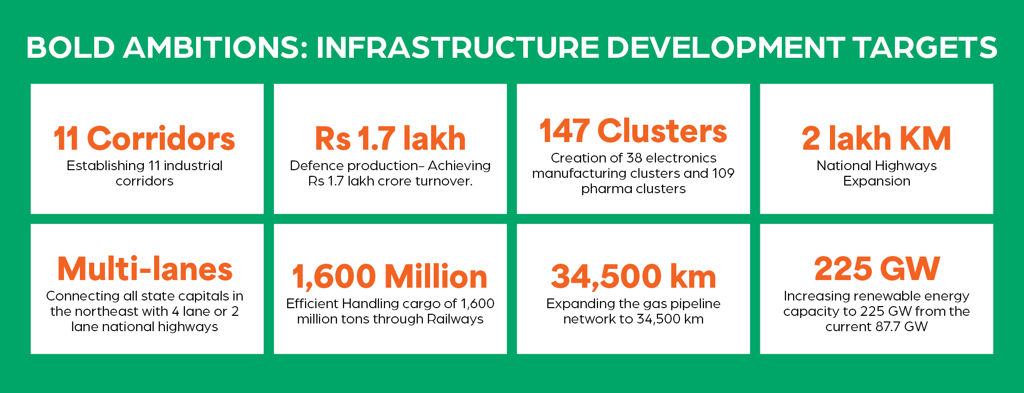
Within the framework of Bharatmala Pariyojana, the focus is on developing approximately 26,000 km of Economic Corridors. These corridors, in conjunction with the Golden Quadrilateral (GQ) and North-South and East-West (NS-EW) Corridors, are anticipated to handle a significant portion of freight traffic on roadways.

“The Gati Shakti framework is a holistic approach to infrastructure development, which aims to integrate various modes of transportation and create a seamless network. This will help to reduce the time and cost of freight movement on highways across countries”, believes Amit Kumar Ghosh.

“We have seen an improvement in the average speed in the economic corridors,” Ghosh added. “This is due to the coordinated efforts of various government agencies and the private sector. We are committed to further improving the infrastructure in the country and making it easier to do business.” Construction of roadways and road networks has always resulted in a substantial increase in the demand for materials such as steel, cement, and bitumen. This domino effect can have far-reaching positive consequences across various sectors of the economy.

Unlocking Socio-Economic Advantages

PM National Master plan ensures efficiency across different sectors of the economy. Accurate modelling and integration of various types of information are of utmost importance towards this is precisely where platforms like PM Gati Shakti come into play. They serve as an essential tool to integrate diverse data sources.

Green highways are an integral part of the PM Gati Shakti National Master Plan for Multimodal Connectivity. The plan aims to develop a holistic infrastructure ecosystem in India, with a focus on sustainability and environmental protection. Green highways are those that are designed and constructed with minimal environmental impact.

They incorporate features such as tree planting, rainwater harvesting, and solar energy generation. “Sustainability and pollution control are paramount concerns along our roads. The concept of Green Highways, with ample room for indigenous vegetation, not only nurtures our ecology but also champions’ sustainability. It’s a stride toward curbing carbon emissions,” affirmed Gen. V.K. Singh (Retd.), Minister of State for Road Transport & Highways and Civil Aviation, Govt. of India.

The PM Gati Shakti National Master Plan also includes a number of initiatives for the development of green highways. These include Greenfield expressways that the government plans to develop 22 Greenfield expressways across India.

These expressways will incorporate features such as tree planting, solar energy generation, and rainwater harvesting. Existing highways will also have solar panels and rainwater harvesting systems which will help it in being environmental friendly. The government also plans to develop 35 multi-modal logistics parks (MMLPs) across India.

These will be designed to be green and sustainable, with rainwater harvesting, solar energy generation, and waste management systems being prominent features. As of date, 14 Social Sector Ministries/ Departments have been on-boarded, namely Ministry of Panchayati Raj, Department of Health and Family Welfare, Department of Post, Department of School Education and Literacy, Department of Higher Education, Ministry of Culture, Ministry of Housing and Urban Affairs, Ministry of Rural Development, Ministry of Women and Child Development, Ministry of Tribal Affairs, Department of Youth Affairs, Department of Sports, Ministry of Skill Development and Entrepreneurship and Ministry of AYUSH.

Moreover, the plan’s successful implementation is anticipated to alleviate the tax burden on citizens, granting them greater financial autonomy.

Railways & Waterways

The Indian Railways stands as an integral pillar of the country’s infrastructure, boasting the distinction of being the world’s fourth-largest railway network, spanning an impressive 67,956 kilometres. Its significance in the Indian economy is undeniable, contributing over 2% to the nation’s GDP.

Given its role in India’s economic landscape, the integration of the Indian Railways into the PM Gatishakti Master Plan becomes not just a choice, but a need. A step towards this integration is the introduction of a 2000 km network, a vital component of the PM Gatishakti National Master Plan. This innovative network will harness the power of the indigenously developed Kavach technology, a system engineered to prevent train collisions, thereby ensuring better security.

Simultaneously, this network will undergo upgrades in capacity ultimately leading to a reduction in congestion and a significant boost in efficiency. As part of the larger scheme to modernize the fleet, the unveiling of 400 new Vande Bharat trains within the next three years is indeed a noteworthy endeavour. With their strategic deployment on major routes across the nation, the Vande Bharat trains will pave the way for heightened connectivity and a substantial reduction in travel time, bridging the geographical divide.

Diversification of focus brings forth yet another commendable initiative – the establishment of 100 cargo terminals within the next three years. This strategic move aligns with the Indian Railways’ broader vision of fostering multimodal logistics facilities. By offering an integrated suite of services including warehousing, packing, and transportation, these terminals become a hub of efficiency for shippers and receivers.

Sources in the railway ministry talk about technology like RFID and GPS tracking, whose terminals not only ensure the secure movement of goods but also elevate the logistics ecosystem to a new standard.

“Worldwide logistics costs typically range between 8-10%. In contrast, India currently bears a hefty logistics cost of around 16%. The PM Gatishakti plan sets its sights on a significant reduction, targeting a logistics cost of approximately 10-12%. Remarkably, even China has achieved a substantial decrease in its logistics costs, prompting us to ponder the path to this achievement. The key lies in comprehensive integration”
Anisur Rehman
Chief Engineer, Northern Railways

We must break down the barriers that separate various transportation systems, ensuring full visibility into railways, waterways, and road transport operations. This approach enables seamless coordination and resource sharing, helping us avoid unnecessary duplication, such as constructing redundant roads.” he added.

This vision shows the integration of all technological components and the active involvement of stakeholders. The objective is to enhance planning, streamline integration, facilitate smoother onboarding processes, and foster stronger collaborations. It is abundantly clear that continuing to work in isolated silos will prove costly. Consequently, all digitization processes and systems are converging into a unified framework.

“Another Ministry that PM Gati Shakti has been able to bolster as a vital engine of economic progress is the Inland Waterways. The enhancement of the logistics framework is paramount, as a robust economy hinges upon a well-functioning logistics system. The logistic policy spearheaded by the government is accelerating project execution and fostering development.

With 111 waterways crisscrossing our land, our logistics landscape has been significantly enriched.

One of the projects is the Jal Marg Vikas Project (JMVP) for capacity augmentation of navigation on National Waterway-1 (NW-1) which is being implemented at a cost of Rs 5369.18 crore with the technical assistance and investment support from the World Bank. The IBP route promises connectivity through Bangladesh to the northeastern states.

A Step Beyond?

“The launch of PM Gatishakti has been praised by industry bodies like the Confederation of Indian Industries, who recognize its potential to transform India’s infrastructure. PM Gatishakti is likely to add value in many ways,”
Geetha Ramamoorthi
, Managing Director of KBR India.

“It will improve connectivity between different modes of transportation and lead to increased trade. This will create more jobs and attract investments. It will also reduce logistics costs, thereby making businesses competitive and more profitable. PM Gatishakti will enhance export and trade, fuel urbanization, and encourage investments.”

It is expected to reduce logistics costs to GDP, establish new multi-modal cargo terminals, and facilitate synergy among various government departments.

“On a national scale, the previous road network initiatives were predominantly structured as Public-Private Partnerships (PPP). Today, we’ve transitioned into an era where every aspect, from locational referencing to maintenance, is comprehensively integrated into various asset management system-based applications”
DR. NC PAL
OSD cum Engineer-In-Chief, PWD

The plan has achieved remarkable progress in the last two years. The foundation of a comprehensive digital platform at the national level serves as a pivotal achievement. It seamlessly connects state-level master plan portals, ministry planning portals, and specialized planning tools, fostering a holistic approach to infrastructure development.

“By making decisions grounded in data, the plan garners greater acceptance and leads to more optimized infrastructure development at cost-effective rates,” adds Dr. Ahirwar.

PM Gatishakti lowers the cost of transportation thereby improving farmer’s income and enhancing food security.

More Prime Read

aerial-view2-lg

Verisk Insurance Solutions to expand imagery database

Data analytics provider Verisk Insurance Solutions, has signed agreements with a number of US aerial imagery and data-capturing firms to fast track the collection of high-quality imagery and data for Property InSightTM

‘Pacific countries are mapping in traditional ways’

Pacific Island countries and territories are challenged by the necessity to update their maps to reflect the present day realities. A related issue is that GPS equipment is not recognised as legal surveying equipment…

the-earth-science-unmanned-aerial-system-uas-demonstration-in-the-rover-scape-75773e-1024

Commaris partners with FIZUAS Unmanned Aircraft Systems

Commaris™, a brand of Terrafugia, Inc. delivering uncrewed aerial vehicles (UAVs) for commercial operations, today announces its dealer partnership with FIZUAS Unmanned Aircraft Systems. This partnership allows FIZUAS to sell