Home 2023 November

Monthly Archives: November 2023

Sateliot and t42 Collaborate to Offer Satellite-Based 5G IoT Maritime Tracking Solution

0
Sateliot and t42 Collaborate to Offer Satellite-Based 5G IoT Maritime Tracking Solution

Sateliot, the first company to operate a Low-Earth orbit (LEO) 5G IoT satellite constellation, and t42, the global expert in providing IoT tracking devices for maritime containers, have signed a collaboration agreement to boost connected containers, enabling shipping companies to save 47 billion euros annually.

t42 will deploy thousands of 5G-IoT sensors in containers for its more than 50 logistics partners across over fifty countries, connecting them to Sateliot’s satellites, thus eliminating the problem of lack of coverage on the high seas. This ensures secure control of merchandise at all times, as these sensors monitor location, acceleration, temperature, humidity, impacts, tilt, light conditions, and container damage, among other parameters, providing intelligent detection of these variables anytime, anywhere.

Currently, 99% of maritime transport containers are not tracked or inspected due to a lack of cellular and satellite connectivity, leading to losses from cargo theft, tampering, accidents, damages, etc. In response, shipping companies are allocating significant investments to make 25% of their containers smart by 2025. Furthermore, maritime companies handle 80% of international trade goods.

Sateliot’s unique technology allows extending 5G NB-IoT connectivity to any part of the world without terrestrial coverage, without operators having to change their hardware, and at a low cost. The significance of this technology lies in the premise that operators can connect to the nanosatellite network via a roaming service when they need to extend their coverage.

Furthermore, the low cost per device and connection is an added advantage driving this innovation.

The First Change in 67 Years

The combination of Sateliot’s technology and t42’s will unleash a revolution in a sector that has mostly stayed the same since Malcolm McLean invented the shipping container in 1956.

Back then, the revolutionary solution came from the new standardized way of shipping goods, with a newly designed container perfectly shaped to fit all ships, tools, and ports. Now, a second revolution comes with the new 5G standard for IoT communications capable of connecting devices seamlessly to satellite (NTN) and cellular networks.

This means that the container will undergo a transformation similar to what the automobile experienced, evolving rapidly from a simple machine that transports you from one point to another to a connected car, becoming a powerful IT tool with many applications.

Jaume Sanpera, Sateliot’s CEO, said: “Our collaboration marks a pivotal moment in the industry’s history, transforming traditional shipping containers into intelligent, connected assets. Tracking in open seas, until now, a very luxurious satellite service will be democratized to all.”

On the other hand, Avi Hartmann, t42’s CEO, challenges other companies and industries to follow their steps. “It is unbelievable what a small hardware investment can represent for the industry’s performance overall. This change has come to stay; there’s no doubt about it.”

Wildfire Preparedness Gets a Boost with UP42 and OroraTech’s Geospatial Data Access Solution

0
Wildfire Preparedness Gets a Boost with UP42 and OroraTech’s Geospatial Data Access Solution

UP42, a geospatial developer platform and marketplace, and OroraTech, a space-based thermal intelligence company, have signed a partnership agreement to grant easy and fast access to global high-resolution thermal-infrared imagery. OroraTech delivers low-latency, global coverage, near-real-time thermal data products.

OroraTech, the first of its kind to join UP42’s growing marketplace of nearly 80 data and processing partners, provides valuable insights to customers during unpredictable events through its newly launched thermal sensor, FOREST-2. Via UP42’s marketplace, the company offers the following data products:

  • On-demand tasking for near real-time data access from anywhere in the world with 400km coverage and 200m resolution on a daily basis.
  • Access to an ever-growing future archive of thermal imagery for past event analysis.

UP42 tasking allows for advanced capabilities such as order tracking, automated delivery, and support for complex and multi-geometry AOIs. Furthermore, OroraTech’s tasked data is managed in UP42’s STAC-compatible storage, simplifying the search and management of data for easier processing and integrations.

“As global temperatures rise, wildfires and heat waves are having an increasing impact on people, the environment, and economies. In 2022 alone, heat waves accounted for 99% of all climate-related deaths in Europe,” said Sean Wiid, CEO of UP42, referring to a recent World Meteorological Organization report. “Expanding our offering with OroraTech’s thermal-infrared data will help our customers build early-warning and monitoring systems to help us mitigate the impact of these climate-related emergencies.”

OroraTech’s high-resolution thermal data serves customers on six continents, ranging from forestry and utility companies to governmental organizations and geospatial experts. Facilitating rapid disaster response, location accuracy, and predictive analytics, its data helps assess risks, minimize losses, and support 24/7 response measures.

“With UP42 our customers have easy and quick access to our thermal tasking capability,” says Axel Roenneke, CCO at OroraTech. “This partnership accelerates our route to the geospatial market.”

Potential of PM Gatishakti National Master Plan in Next-Gen Infra Development

Potential of PM Gatishakti National Master Plan in Next-Gen Infra Development

In an interaction with Geospatial World, Anisur Rehman, Chief Engineer, Northern Railways speaks about the emerging trends and innovations that are shaping India’s Infra development; how geospatial technology is revolutionizing the design and construction of next-gen infra, and its role in Achieving PM GatiShakti’s Vision.

Ayodhya to Become a Model Vedic Sustainable City

0
Ayodhya to Become a Model Vedic Sustainable City

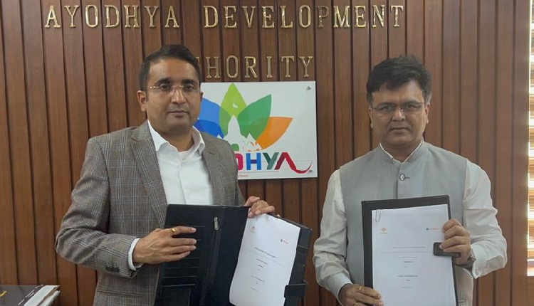
The Ayodhya Development Authority has signed an MOU with Gurugram-based Arahas Technologies, an AI and geospatial expert company. The strategic collaboration aims to leverage advanced technologies to create a comprehensive Sustainability Index for Ayodhya, propelling the city towards becoming a global exemplar of Vedic principles and modern sustainability.

The Ayodhya Development Authority has selected Arahas Technologies to pioneer the transformation of Ayodhya into the world’s first Vedic Sustainable City. The partnership formalised through a Memorandum of Understanding (MoU), marks a significant milestone in Ayodhya’s journey towards sustainable urban development.

The project will call for an investment of around 1 Mn USD in the first phase which shall be covered by ARAHAS Technologies. The first release of the Vedic Sustainability City Index is scheduled for January 2024 with quarterly updates.

Arahas Technologies will deploy its advanced AI algorithms and geospatial analytics to create the Vedic Sustainable City Index Platform. This platform is poised to revolutionise decision-making for sustainable practices, providing real-time insights into Ayodhya’s environmental, societal, and economic dynamics.

Ayodhya, with its population of 24.70 lakhs and a significant influx of tourists annually, faces challenges that necessitate a strategic and coordinated approach. The Vedic Sustainable City Index will serve as a structured solution, offering a comprehensive framework to assess sustainability across various dimensions, including environmental, social, economic, and governance factors.

The Ayodhya Development Authority envisions the city’s development as rooted in Vedic principles, blending tradition with modernity. The Vedic Sustainable City Index aims to preserve and revitalise the city’s cultural heritage, promote spiritual and holistic well-being, foster environmental stewardship, and drive economic prosperity through ethical practices.

Shri Vishal Singh, Municipal Commissioner of Ayodhya and Vice Chairman of Ayodhya Development Authority remarked, “The Vedic Sustainable City Index unveils a visionary future for Ayodhya, presenting a harmonious blend of tradition and modernity. Ayodhya Development Authority envisions the development of city rooted in Vedic principles, nurturing the well-being of its inhabitants, fostering environmental stewardship, and embodying United Nation Sustainable Development Goals (SDGs). This strategic partnership with Arahas Technologies marks a crucial step towards achieving our vision. The platform’s capabilities, coupled with the coordinated approach facilitated by Ayodhya Development Authority, will empower us to address urban challenges effectively. Through the Vedic Sustainable City Index, Ayodhya aspires to become the first temple town that would proactively report its sustainability indices and server as a model to set the stage for a thriving and resilient urban future.”

Mr. Saurabh Rai, Chief Executive Officer of Arahas Technologies Pvt ltd, added, “By setting up the Vedic Sustainable City Index, Ayodhya is not only ready to compete with global cities but will lead the way for Indian Urban Local Bodies (ULBs). The integration of advanced AI algorithms and geospatial analytics in our platform ensures a nuanced understanding of Ayodhya’s dynamics, be it environmental, societal, or economic. This initiative reflects our commitment to catalyse sustainable development and provide decision-makers with real-time and predictive insights. We believe that Ayodhya’s embrace of the Vedic Sustainable City Index will set a benchmark for other cities, encouraging a comprehensive and adaptive approach to urban sustainability.”

New Merger Ushers in Era of Enhanced Location Intelligence

0
New Merger Ushers in Era of Enhanced Location Intelligence

Gravy Analytics, the enterprise location intelligence company, and Unacast, the location insights and data company, today announced a definitive agreement to merge, creating one of the largest and most comprehensive location analytics platforms in the industry.

The merger sets in motion a period of accelerated new product development and market expansion. Through synergies in data processing, the organization will quickly ramp investments in machine learning and AI, its self-service Insights platform and suite of analytic APIs, as well as its proprietary data processing technologies.

In the rapidly growing $22 billion global location intelligence market, scale and reach are paramount for any trusted data and analytics partner. With a strengthened footprint in both the U.S. and international markets, the combination of Gravy and Unacast will enhance service deliverability and support for clients across continents.

“We’re creating THE global location intelligence company built for where the industry is headed,” said Thomas Walle, founder and CEO of Unacast. “By combining Unacast’s strengths in aggregated analytics, AI, and machine learning with Gravy’s global data and processing technology, we will better serve our customers both now and in the future.”

The fusion of both companies’ data, technologies, and products gives existing and future clients unparalleled access to rich location data insights and high-quality datasets.

Customers benefit from on-demand access to privacy-friendly insights and data that reflect real-world consumer activity, enabling insights for decision-making in markets including real estate, retail, finance, and advertising.

“Gravy’s high-quality location data supports critical business decisions for some of the biggest organizations in the world,” said Jeff White, Gravy Analytics founder and CEO. “Now, we’re bringing our data products to markets and SMBs that haven’t been able to work with massive datasets or benefit from the incredible insights that location analytics provide. This is a game-changer.”

Enterprise customers historically rely on Gravy’s location data products to improve advertising and marketing performance and power industry-specific research platforms.

Unacast’s machine learning and AI technology provide companies of all sizes with the best location-based insights to make the right data-driven business decisions. Together, the new company’s strength is in its diversified client base and an integrated product suite that is second to none.

The combined company will be headquartered in Ashburn, Virginia, with offices in Oslo, Norway, and Pilsen, Czech Republic. Mr. Walle will continue as CEO of the combined company with Mr. White serving as President.

Satellite Images Provide Glimpses into Gaza Aid Deliveries

0
Satellite Images Provide Glimpses into Gaza Aid Deliveries
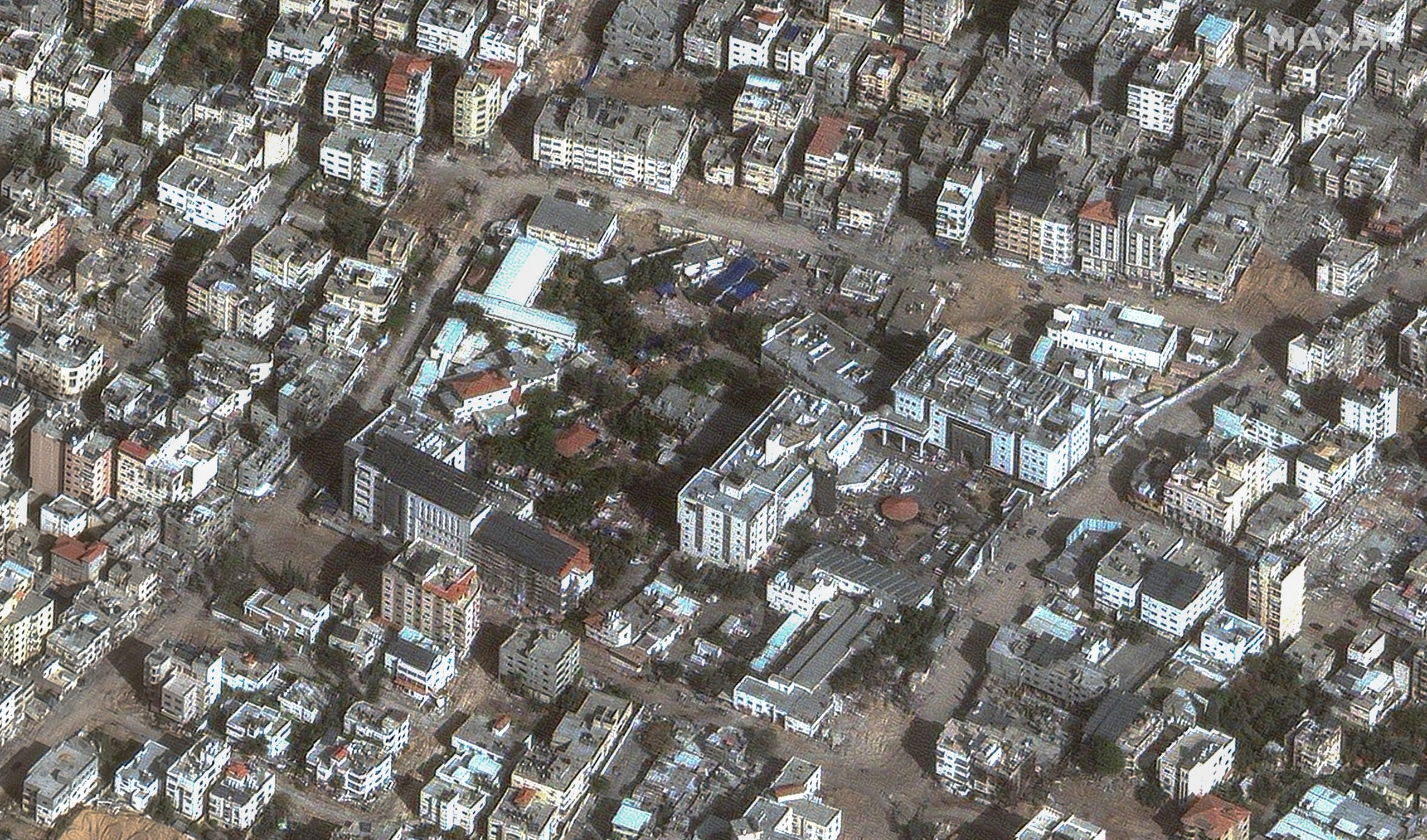
indonesian hospital, gaza city


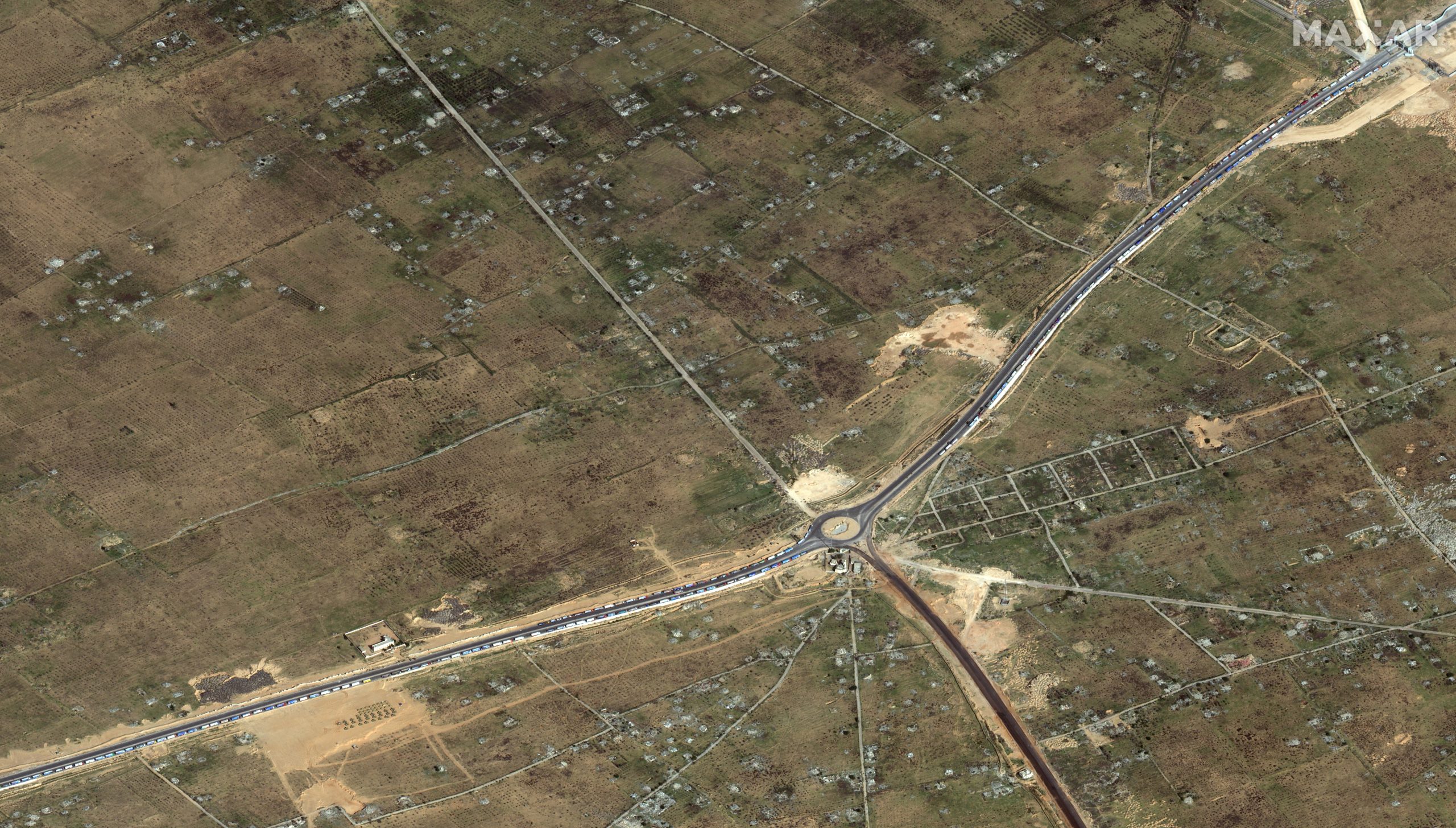
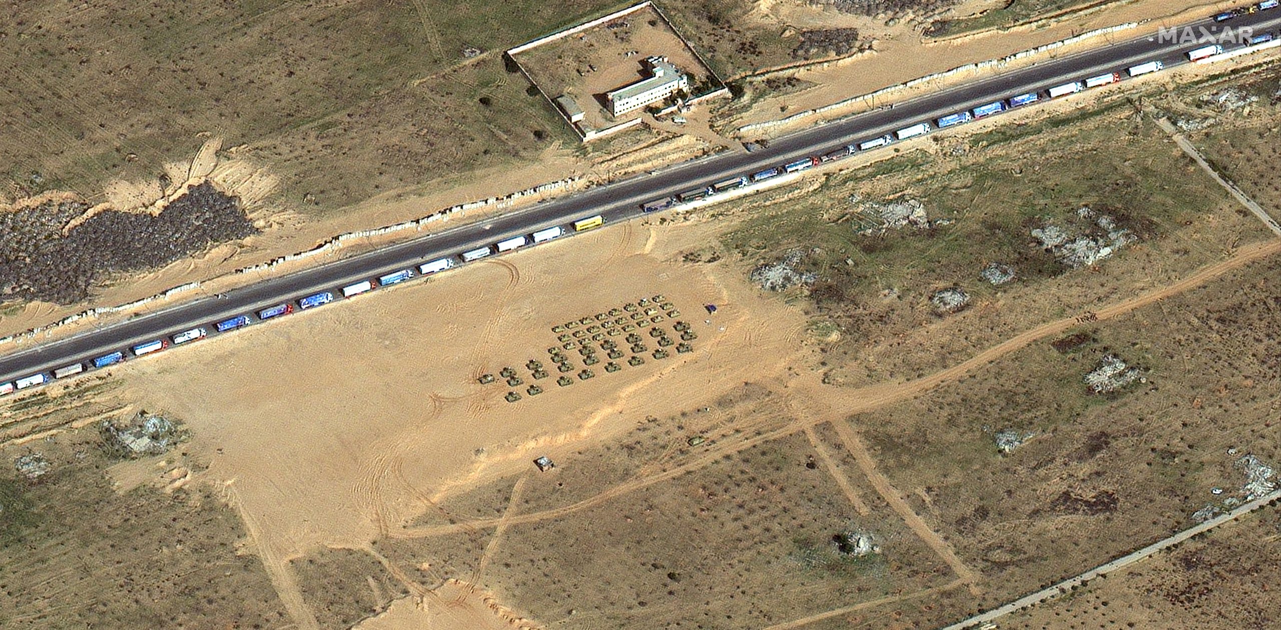
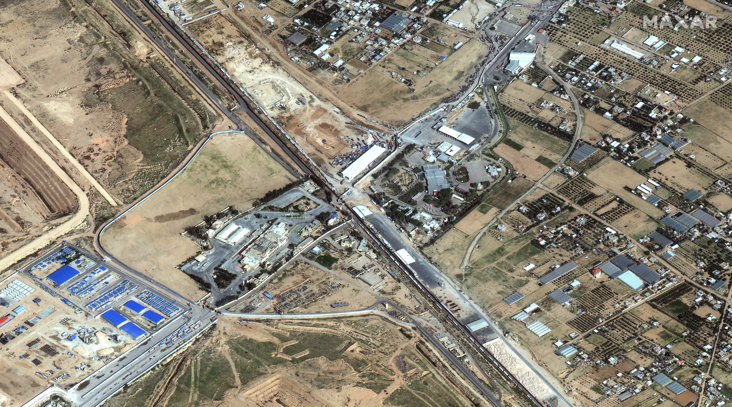
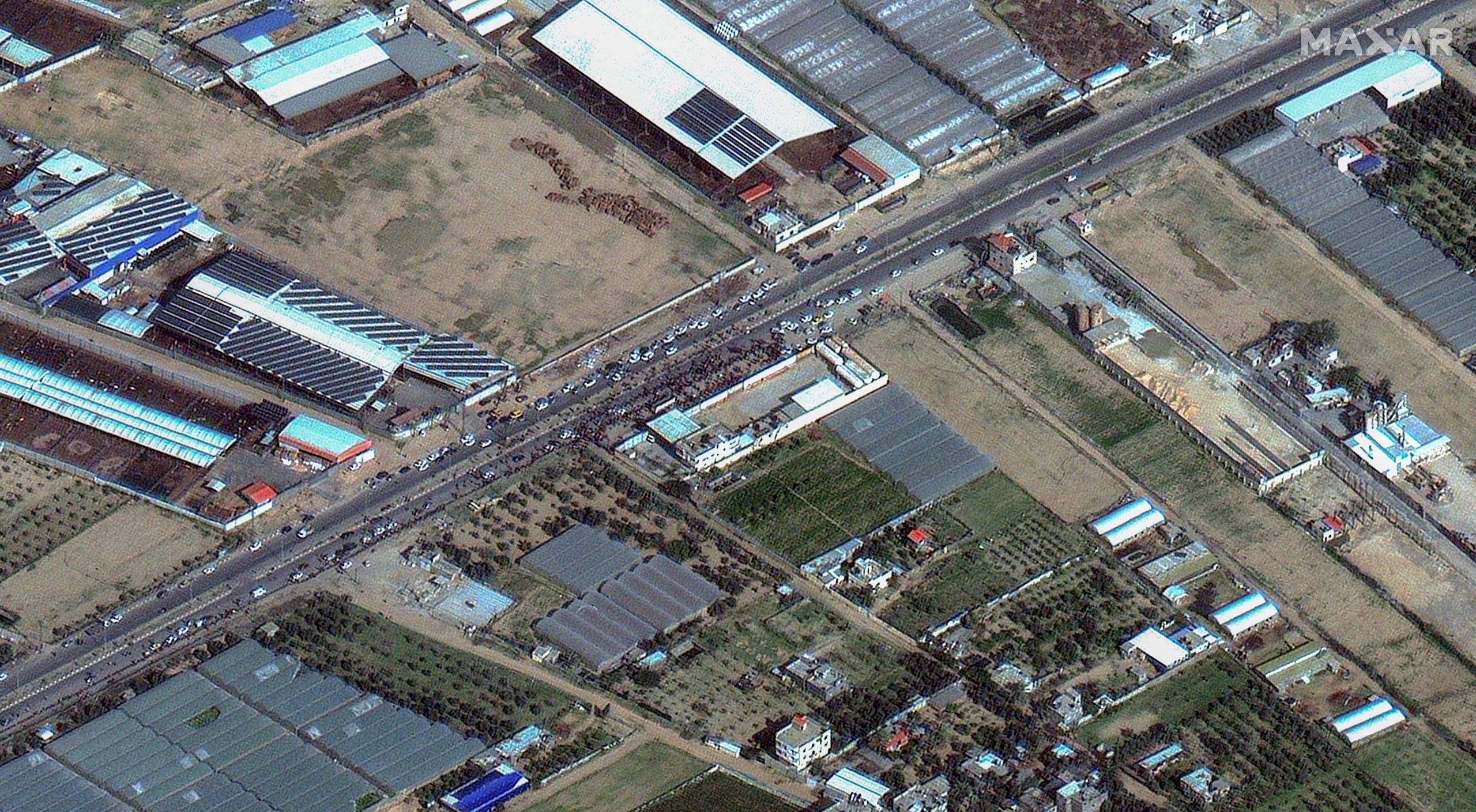
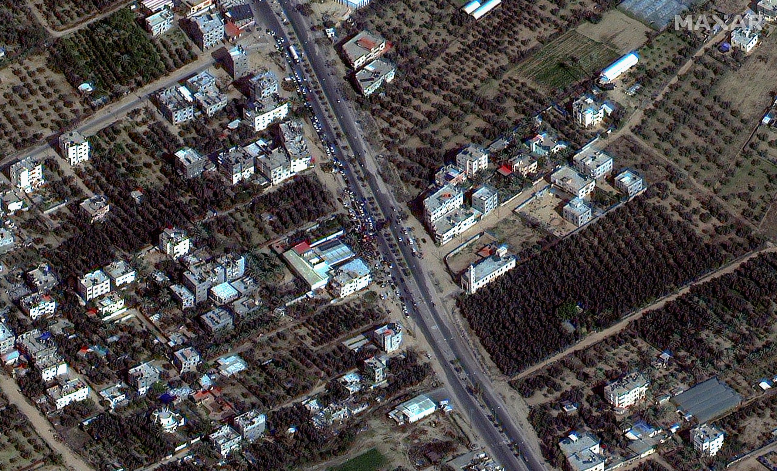
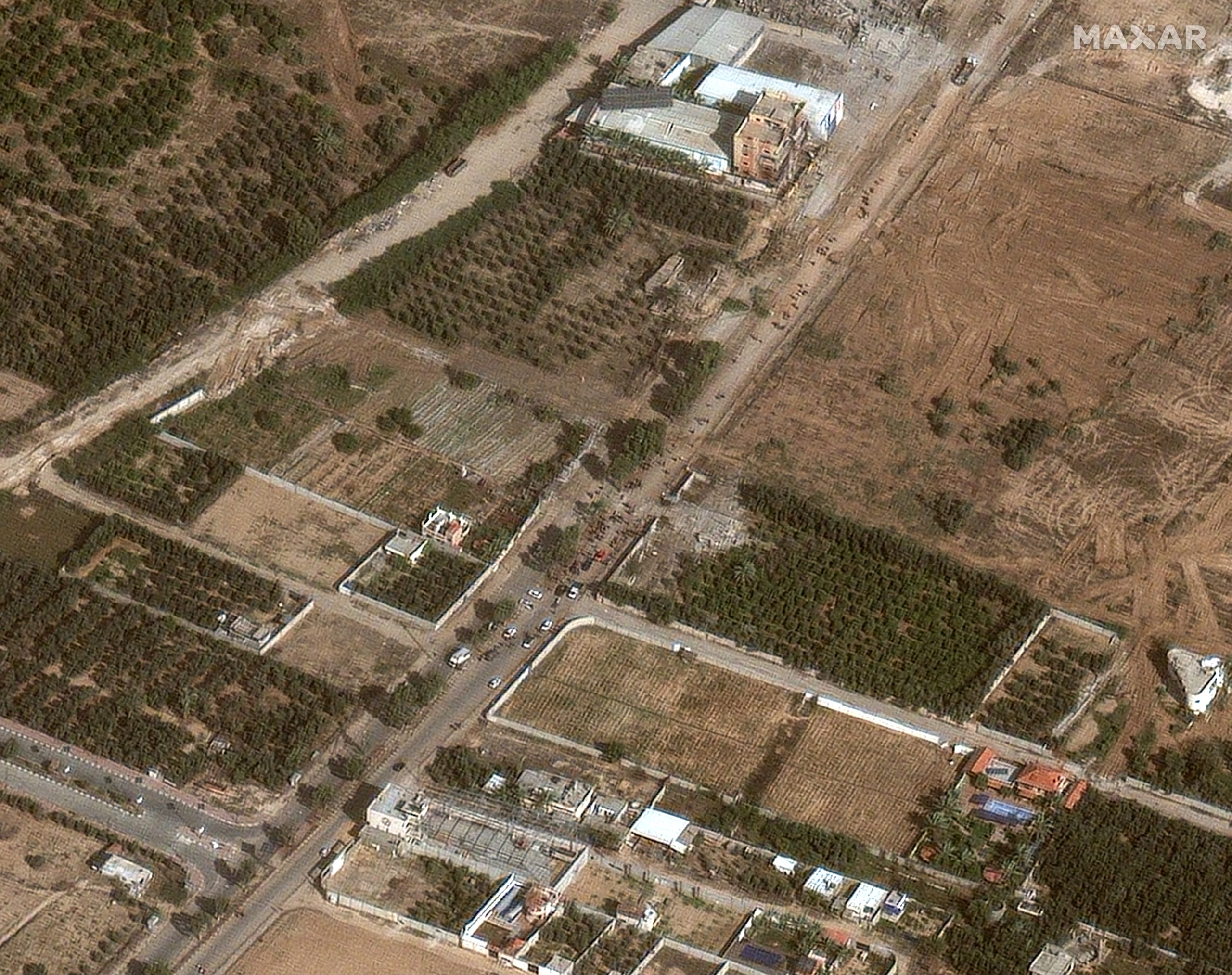
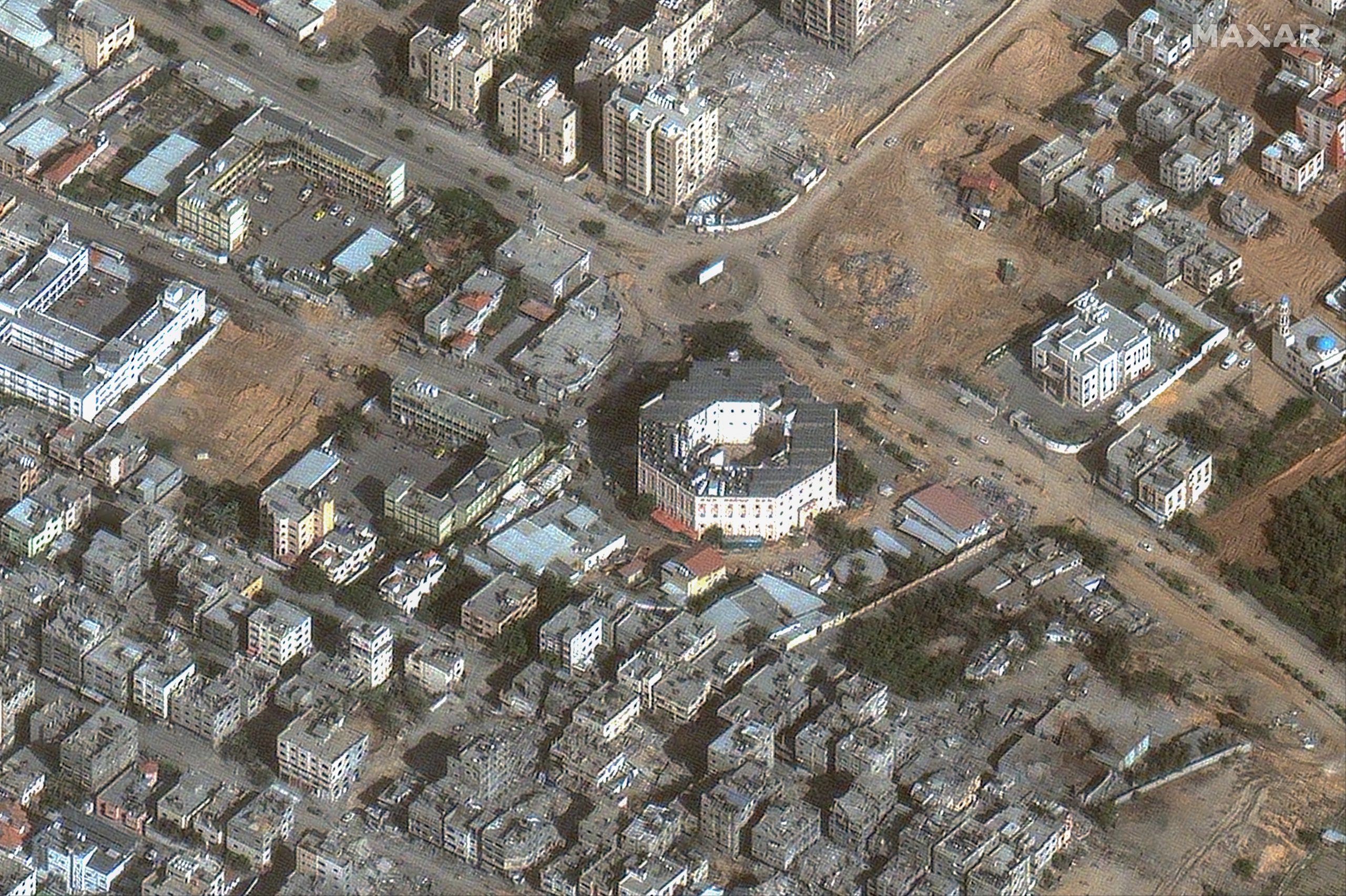
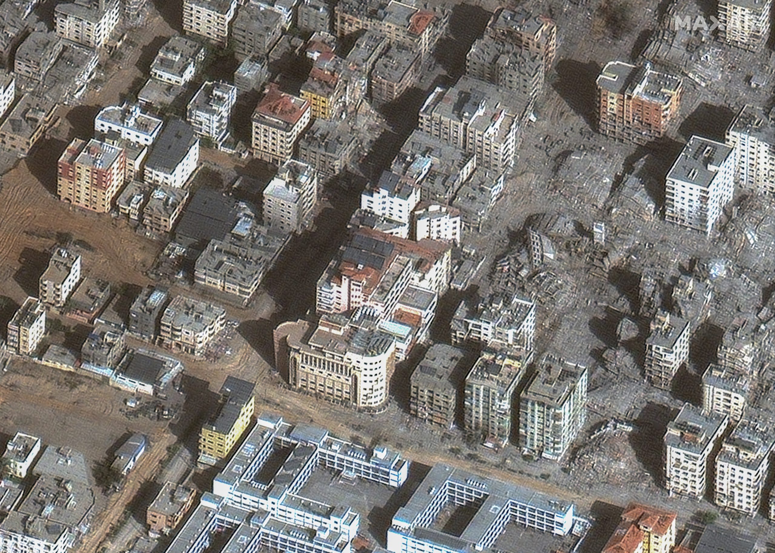
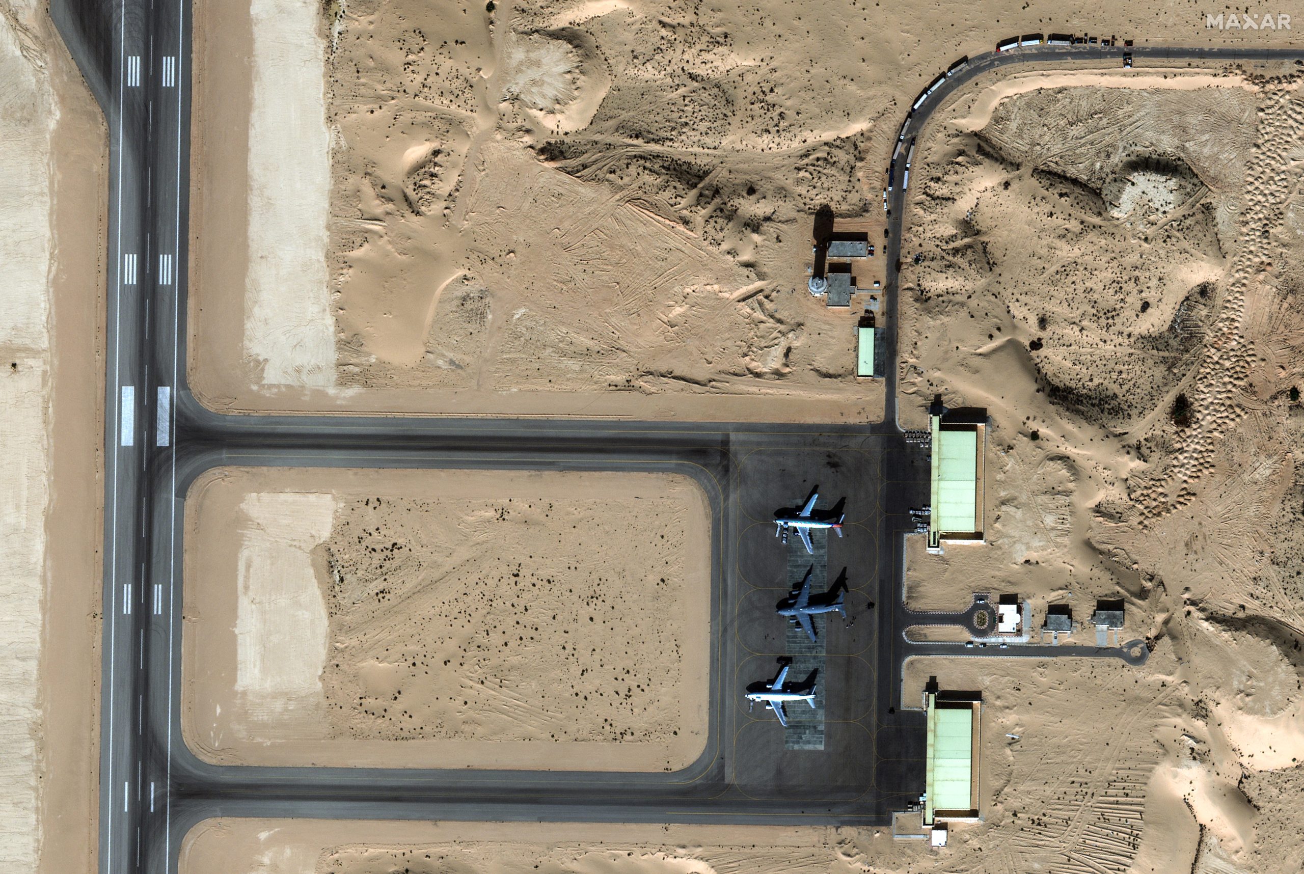
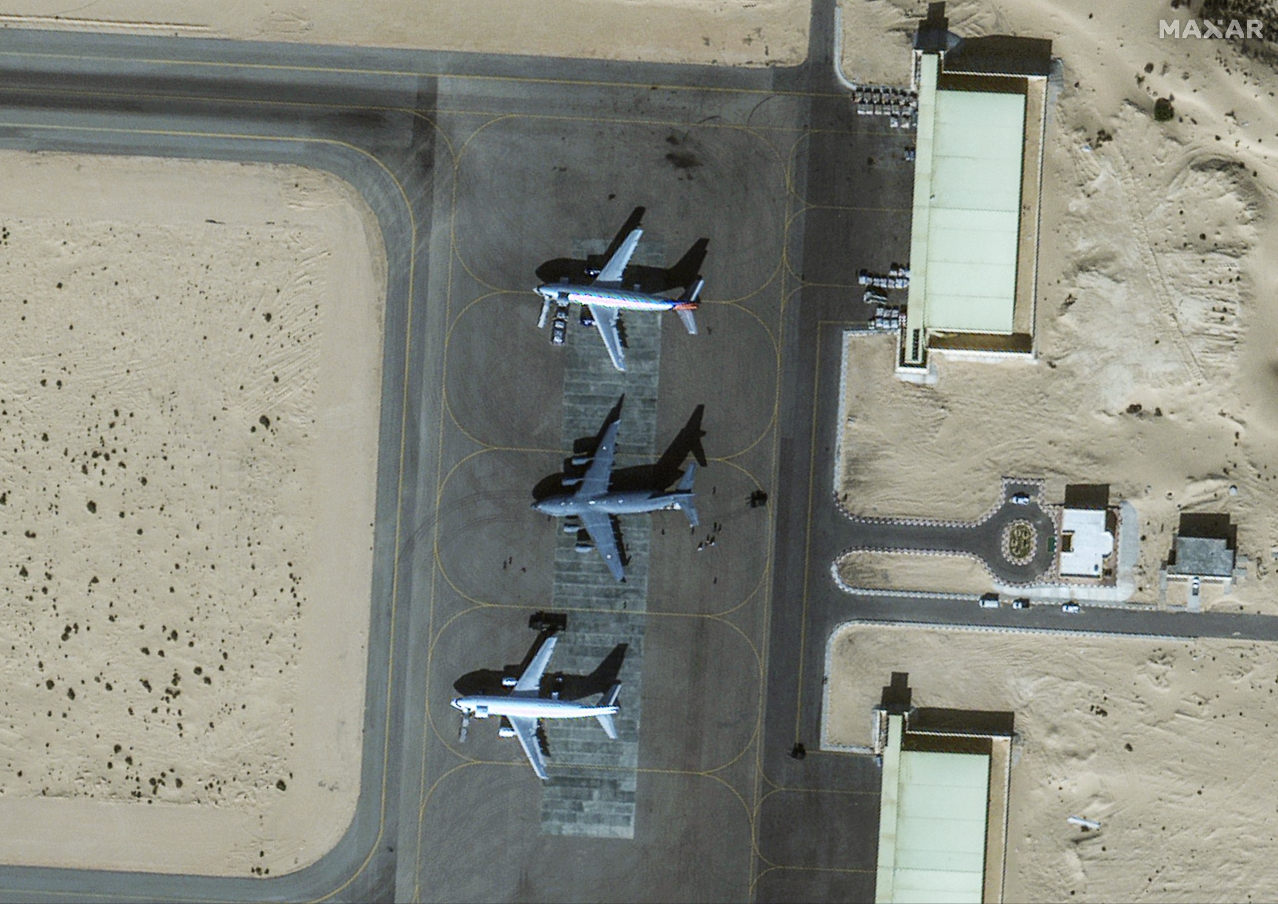
Maxar Technologies, a provider of high-resolution satellite imagery, has released a series of images captured on November 26th that provide valuable insights into ongoing efforts to deliver food and supplies to Gaza during the current ceasefire between Israel and Hamas. The images, which were shared with European Space Imaging (EUSI), highlight several key points of interest, including:

  • Humanitarian aid trucks approaching the Egyptian border with Gaza. These trucks are carrying essential supplies, such as food, medicine, and water, to the besieged Gaza Strip.
  • Crowds near gas and propane storage stations. Gazans are lining up to purchase these essential fuels, which are in high demand due to the ongoing blockade.
  • Individuals walking along Gaza’s Salah al-Din road. This major thoroughfare is bustling with activity as Gazans go about their daily lives.
  • Key hospitals in Gaza City. These facilities are providing critical care to Palestinians injured in the recent conflict.
  • Additional aid supplies arriving at El Arish airport in Egypt for Gaza. These supplies are being transported to Gaza via the Rafah border crossing.

These images provide a stark reminder of the ongoing humanitarian crisis in Gaza. Despite the ceasefire, the Gaza Strip remains under blockade, and its residents continue to face severe shortages of food, fuel, and medicine. The international community must continue to provide humanitarian assistance to Gaza and work towards a lasting peace agreement that will allow for the lifting of the blockade.

ISG ISRS National Symposium 2023: Day 2 Exhibit Deep-Dive Sessions

0
ISG ISRS National Symposium 2023: Day 2 Exhibit Deep-Dive Sessions

At the second day of the ISG ISRS Symposium 2023, plethora of speakers discussed and presented their ideas to augment capabilities of geospatial technology and help in advancing the nation. The symposium, held at Symbiosis International (Deemed University), Pune, gathered speakers and audience from industry, government, students, and users.

While discussing the growing role of geospatial in governance, NESAC director Dr. SP Agarwal explained his organization’s work and tools developed to protect electoral process and aid in better governance practices in the north-east region of India.

He further explained how geospatial governance models can be expanded to other parts of the country for making efficient decisions

Dr. Sameer Saran, DGM, Regional Remote Sensing Centre-North, explained the impact of geospatial technology in governance. He said, “Geospatial technology is game changer and plays a vital role in governance. It provides access to services and benefits at doorsteps with complete transparency.”

He further said that geospatial database is the backbone for any and every decision now as it provides value, timeliness, and informed decision making.

Emerging technologies such as IoT, AI, Cloud, and Big Data are turning into main components for geospatial technologies, he exclaimed.

Many other themes such as Emergency and Disaster Management, Geoinformatics for Renewable Energy and Rural Urban Infrastructure, Spatial Economics and Sustainability, HPC and Machine Learning were discussed simultaneously at the university.

Titiksha Bhatia, Software engineer at IIT Kanpur, a major user of geospatial technologies discussed about Comparative Analysis of Ground Filtering Methods for 3D LiDAR Point Clouds. When asked about the requirement from government and industry’s side, she said “with the 3D road detection and navigation method, we expect government to make data more open and accessible to make better cities and smart city.”

She also explained about her road detection method, “Road detection is a difficult task given the noise (objects other than road) are almost always present. It is necessary to filter this noise out. Right now the project is at the stage where we are filtering out the ground points from the rest of the above ground points and extracting the road and then further working on the navigation in 3D setup.”

Another perspective was discussed by professor Anjana Vyas, Ph.d, about the assessment of learning pedagogy in geospatial technology and spatial information science education. She explained the importance of geospatial knowledge at the colleges and universities.

She brought forth five parameters of planning, development, process, and product and developed a formula for distributing weightage to them accordingly for a geospatial course.

With various other technical presentations and programs, the second day at ISG ISRS Symposium 2023 brought forth deep-dive sessions and thought-provoking discussions.

UNESCO Recognized Weather Intelligence AI Solution to Shine in COP 28

0
UNESCO Recognized Weather Intelligence AI Solution to Shine in COP 28

SI Analytics Weather Intelligence AI Solution recognized by UNESCO, and taking the stage at ‘COP 28 UAE’

Taegyun Jeon, CEO and founder of SI Analytics, will present an AI-based climate prediction solution at COP 28 (the 28th Conference of Parties to the UN Framework Convention on Climate Change) in Dubai, United Arab Emirates, starting on the 30th.

The presentation, recommended by UNESCO, was selected as the winning case in the ‘AI For Good-AI/ML Solutions for Climate Change’ challenge, a digital platform under the UN ITU (United Nations International Telecommunication Union).

SI Analytics will showcase weather intelligence AI solutions led by Dr Yeji Choi and Doyi Kim, research scientists of the Earth Intelligence Division, addressing global issues caused by weather data inequity and climate change using AI. Dr. Yeji Choi mentioned that the SI Analytics weather intelligence solution will contribute to the UN’s ‘Early Warning for All’ initiative.

‘GeoCloud’ aims to improve the accuracy of weather and climate predictions by anticipating the movement of clouds, while ‘GeoRain’ aims to provide accurate prediction data, ensuring a high temporal resolution of 2km. This capability allows the monitoring of sudden heavy rainfalls, such as flash floods, and provides detailed climate information even to more remote regions such as small island nations in the Pacific.

These solutions accurately predict the weather in meteorologically underserved areas deprived of physical weather radars. It is anticipated that combining recently developed typhoon path prediction models with GeoRain and GeoCloud will enable rapid preparedness for disasters such as typhoons.

Furthermore, the ‘Building Damage Assessment’ service, contributing to disaster recovery from severe weather and climate changes, aims to offer precise insight into damage recovery by swiftly detecting damage over a wide area. SI Analytics ultimately contributes to decision-making data, with typhoon landing area prediction and damaged infrastructure assessment, aiming to minimize the scale of damage caused by climate change.

Doorda and Point Sigma Improve AI-driven Analytics by Incorporating UK Data

0
Doorda and Point Sigma Improve AI-driven Analytics by Incorporating UK Data

Doorda, a British analytics-ready data provider, has partnered with Point Sigma, the world’s first fully end-to-end, autonomous AI-driven data analytics solution. Doorda’s trusted, unique data – gathered only from official sources in the UK – is now a core part of Point Sigma’s platform which broadens the reach of analytics to all decision makers and creates significant competitive advantage for clients.

Identifying and swiftly responding to data-driven insights across a range of needs from marketing and credit risk through to customer service and collections is now a common, business critical requirement. The ability to access and analyze large amounts of data is a necessity, but with a large universe of data sources, understanding complex data set relationships, and applying analysis to provide those insights in a timely manner presents enormous technological and resourcing challenges.

Combining their internal data with easily integrated Doorda data, Point Sigma is helping companies to save time and discover key insights from these large data sets in minutes. They are now able to test hypotheses around end-customer demographics, geographical, property and affluence data through self-service visualizations that are set up automatically without needing input from experienced data practitioners.

Funding Circle was one of the first customers to benefit from combining the Point-Sigma and Doorda products. Part of the Funding Circle data landscape is a vast collection of public data from official organizations, such as local and national governments, regulatory agencies and other public bodies, all provided by Doorda.

According to Rohan Karunanayake, Head of Existing Borrower and Investor Analytics at Funding Circle: “We know the value of this data, and already use it in our machine learning models. The question is: do we use all the relevant insights, and are we not missing anything important that could help us make faster and better decisions?”After spending just a few minutes with Point-Sigma exploring and using automatically generated insights, a junior Funding Circle data scientist was able to form a detailed understanding of many aspects of the business and its customers through visual exploration of statistical hypotheses that would otherwise have taken many months to complete, ultimately leading to faster and better decision making.

Funding Circle uses sophisticated analytics to track its performance through a number of key indicators, such as campaign response rates, application success rates, credit scoring, payment performance and more.

Leo Pape, CEO, Point Sigma, said: “Data is one of the most valuable assets for any organization, yet few manage to unlock the full power it holds. Modern AI is still constrained by the demand for impeccably curated datasets, and particularly falls short in data analytics applications. Point Sigma applies the power of AI to understanding raw business data, empowering users to effortlessly explore data, enabling quick, informed decisions that drive value for its organization, stakeholders and customers.

Clifford McDowell, CEO, Doorda, said: “The universe of public data is expanding and evolving, and it is imperative for companies to associate that vast variety and volume of data with their other data to swiftly drive transformative insights and business outcomes. We are delighted that clients such as Funding Circle are deriving great value from our data and joint projects with Point Sigma”

World’s First Map Using Fully Autonomous Plant Stand Counting

0
World’s First Map Using Fully Autonomous Plant Stand Counting

The machine learning model within SWAT CAM analyzes each image and calculates individual plants per acre or per square foot, as well as the average measurements of plant spacing. The tool is available for corn, soybean, canola, and potatoes.

SWAT CAM technology developed by Croptimistic is a crop monitoring tool for farmers and service providers. It has recently been updated to include a new plant stand count feature which automates the manual process of driving fields and performing subjective plant counts at multiple locations or flying a drone with image capture.
SWAT CAM mounts on sprayer booms and autonomously captures images every 60 feet. With no interface in the cab, there’s no action required by the farmer. The images are automatically uploaded to Croptimistic’s SWAT RECORDS software where machine learning models assess and segment crop versus weed data, creating an auto-generated map that summarizes these populations by SWAT zone.

This allows farmers and agronomists to evaluate and adjust variable-rate seed/planting, fertilizer, or herbicide strategies to optimize crop establishment and develop SWAT-based prescriptions that target weed pressures across the field.

With the new plant stand count feature, the machine learning model within SWAT CAM analyzes each image and calculates individual plants per acre or per square foot, as well as the average measurements of plant spacing. The tool is available for corn, soybean, canola, and potatoes. More to come with the continuous future development.

“With SWAT CAM now having the ability to perform plant stand counts, it completely eliminates the need for human involvement in this labour-intensive process. It provides a 1000x higher resolution of counts and is completely objective and consistent,” says Derek Rude, VP of Research and Development at Croptimistic. “SWAT CAM uses constantly improving machine learning models to conduct these assessments. This is the pinnacle of observing what’s happening in the field.”

“This is a day we had marked on the calendar,” says Cory Willness, CEO of Croptimistic Technology. “We are very excited to be able to spend our time analyzing the profitability of seed applications rather than driving around for a month to capture a few observations. In an era of agriculture where greenhouse gas emissions are scrutinized and farmers need the best data possible to make decisions, this technology becomes a no-brainer. We can now collect 1000x the plant stand data with substantially lower GHG emissions and do it for the same cost as people with trucks.”

India and US to Launch Joint Satellite for Earth Observation

0
India and US to Launch Joint Satellite for Earth Observation

India and the US will launch the joint microwave remote sensing satellite for Earth observation, named NASA-ISRO Synthetic Aperture Radar (NISAR) in the first quarter of next year, said Union Minister Dr Jitendra Singh during a meeting with a high-level delegation of NASA led by its Administrator Mr Bill Nelson.

NISAR is targeted for launch onboard India’s GSLV. Data from NISAR will be highly suitable for studying the land ecosystems, deformation of solid earth, mountain & polar cryosphere, sea ice and coastal oceans in regional to global scale.

It was informed that ISRO’s S-band SAR was integrated with NASA’s L-band SAR at JPL/NASA and integrated L & S band SAR is currently undergoing testing with the satellite at URSC, Bangalore with participation of NASA/JPL officials.

Congratulating Dr Jitendra Singh for the historic Chandrayaan-3 landing on the virgin South Polar region of the Moon, Mr Nelson urged Dr Jitendra Singh for expediting the programme related to India’s first astronaut aboard a NASA rocket to the International Space Station (ISS). During the visit of Prime Minister Narendra Modi to the US earlier this year, the two sides agreed to launch a two-week joint India-US Space flight next year. NASA is identifying an opportunity in the Private Astronaut Mission for Indian Astronauts in 2024.

ISRO and NASA have formed a Joint Working Group (JWG) on Human spaceflight cooperation and are exploring cooperation in radiation impact studies, micro meteorite & orbital debris shield studies; space health and medicine aspects. The 8th meeting of India-USA Joint Working Group on Civil Space Cooperation (CSJWG) was held in Washington DC in January 2023.

ISRO/DoS is also in discussion with prominent US industries (like Boeing, Blue Origin & Voyager) on specific items of cooperation and also to explore joint collaborations with Indian commercial entities.

The Indian side informed that a concept paper on the Implementing Arrangement (IA) is under consideration between ISRO and NASA. After a few iterations, both sides arrived at a mutually agreed draft and the same is processed for intra-Governmental approvals.

ISRO is also exploring the feasibility of utilising NASA’s Hypervelocity Impact Test (HVIT) facility for testing Gaganyaan module Micrometeoroid and orbital debris (MMOD) protection shields.

Dr Jitendra Singh said, India has a booming Space sector Startups since PM Modi initiated reforms in the Space sector. Within a short span of just about four years, the number of Space Startups has gone up from a mere single digit to over 150, with some of the earlier ones having turned into lucrative entrepreneurs.

Mr Nelson, himself an astronaut who flew with the crew of the 24th Space Shuttle flight onboard ‘Columbia’ in 1986, lauded ISRO for having launched 231 satellites from the US, onboard Polar Satellite Launch Vehicle (PSLV).

Mr Nelson said he was looking forward to meeting India’s cosmonaut Rakesh Sharma in Bengaluru tomorrow.

The US Ambassador to India, Mr Eric Garcetti was also present in the meeting.

Disaster Response and Recovery through Geospatial Tech

0
Disaster Response and Recovery through Geospatial Tech

The second panel of the AGI GeoResilience Symposium, held today, brought together experts to discuss the role of geospatial technologies in advancing disaster response and recovery. Effective disaster management strategies have become increasingly crucial in the face of intensifying natural disasters and climate change.

Data Democratization

Ashish Kumar Jena, Joint Special Relief Commissioner, Govt of Odisha, emphasized the importance of data democratization in disaster management. Many agencies are creating their own data like land records department, forest management and disaster management departments. These data are possessively held within their own departments. There is a need for accessibility of these data by every department as well as the public domain that can seamlessly operate without any setbacks.

He highlighted the issue of duplication of efforts that results in a loss of efficiency within departments, stating, and “One of the major causes of concern that is duplication of efforts. There is a lot of data available but due to each department being very protective of their data and wanting to create their own niche, there is a lot of data being created without any integration.”

To address this challenge, Mr. Jena advocated for “oneness of technology,” citing the success of Kerala’s Disaster Tracking tool as an example of effective data integration. He also stressed the need for capacity building among stakeholders to ensure the effective utilization of geospatial technologies.

Dr. Milap Punia, Centre for the Study of Regional Development, School of Social Sciences, Jawaharlal Nehru University, discussed the Sendai Framework, a global framework for disaster risk reduction. He said, “The Sendai Framework focuses on the adoption of measures which address the three dimensions of disaster risk (exposure to hazards, vulnerability and capacity, and hazard’s characteristics) in order to prevent the creation of new risk, reduce existing risk and increase resilience.”

He emphasized the importance of the NGP (14 fundamental layers) in providing a standardized framework for geospatial data.

Dr. Punia also highlighted the role of UNGGIM in providing disaster services and a need to focus on loss and damage, recognizing the importance of recovery in disaster management. He also called for increased government funding and foresight into technological advancements.

New Data, Geospatial Readiness, and Data Transferability

Sreeramam GV, CEO, NeoGeoInfo Technologies, emphasized the need for new data, stating, “The world is changing very fast. We need new data, data on demand.” He also stressed the importance of geospatial readiness and the need for accurate, localized data that can be easily transferred between platforms.

Mitika Garg, Senior Solutions Architect, Oracle, advocated for a single enterprise system that integrates different datasets, enabling seamless data sharing and utilization. She said, “There is a need for scalability in applications using ML and IoT for effective disaster management.”

Data democratization, eliminating duplication, embracing the Sendai Framework and NGP, and incorporating UNGGIM’s services are essential steps forward critical role of geospatial technologies in enhancing disaster response and recovery. Moreover, the need for new data, geospatial readiness, accurate localized data, data transferability, a single enterprise system, and scalable ML/IoT applications must be addressed to optimize disaster management strategies.

NaviC Needs to Be More Interoperable for Widespread Adoption, says ISRO Chairman

0
NaviC Needs to Be More Interoperable for Widespread Adoption, says ISRO Chairman

At the three-day ISG ISRS Symposium 2023, S. Somnath explained the need and importance of India’s indigenous navigation system NaviC. The symposium held at Symbiosis International (Deemed University) featured ISRO chairman at the Vikram Sarabhai memorial session.

NaviC currently consists of 7 satellites that cover India and 1500km beyond the country’s boundary. However, only 5 of these satellites are in operation due to which a string of challenges are presented which were addressed by Somnath.

He said, “The commercial segment is not incorporating the NaviC system due to the presence of well-established systems like GPS.” Another challenge that Somnath presented was making NaviC compatible for multi-GNSS as well as providing regional services.

He put down some pointers to take note of these challenges:

  • Improve user adoption
  • Complete the 7-satellite
  • Make it interoperable with other systems to accelerate adoption
  • Add 4 more satellites to the constellation

Somnath also pointed out the various benefits of NaviC such as civilian safety, fishermen’s aid, real-time train information system, geofencing, strategic encrypted signals for PNT, and power grid synchronization.

Once NaviC gets to its full prowess, its ability to shadow GPS will remain to be seen. However, with India’s ambitious space plan, the realization of NaviC as a solid alternative to GPS is not off the cards.

ISRO to Develop Space Station, Next-Gen Lunar Vehicle by 2040

0
ISRO to Develop Space Station, Next-Gen Lunar Vehicle by 2040

For decades, space technologies and data have served humanity in good faith. Space agencies worldwide have embarked on remarkable journeys that have propelled their respective economies and technological advancements.

The Indian Space and Research Organisation (ISRO) also plans on standing shoulder-to-shoulder with some of the biggest space agencies in the world such as NASA, Roscosmos, CNSA, and ESA.

At the ISG ISRS Symposium 2023, the chairman of ISRO, S. Somnath laid out the future roadmap for the government body with key projects lined up. On the first day of the symposium, held at Symbiosis International (Deemed University),

Talking about Vision Amritkaal, a program set up by the Prime Minister of India, S Somnath said, “the honorable prime minister reviewed the progress of Gaganyaan Mission as well as outlined India’s future space exploration endeavours through some directives.”

Bharatiya Antariksha Station

He laid out the directives for Bharatiya Antariksha Station (Indian Space Station) that shall be launched by 2035. Later Indian man missioned lunar landing would be carried out by 2040. A new launch pad, next-gen lunar vehicle (NGLV), human-centric laboratories, and interplanetary missions are in the pipeline.

The human space exploration aspect of space research has come back into fashion again. As Somnath said, “There’s been a global renewed interest for human spaceflight. This will be addressed by building national capability for sustaining human presence in space, as well as, collaboration for astronaut pool creation.”

Somnath dived deep into the development of the Indian Space Station – the Bharathiya Antariksh Station – where he emphasized that the basic R&D enabled Robotic Space Station Capsule can be placed in orbit by 2028. The station can be further expanded to full capacity by 2035.

One of the most coveted partnerships for the Indian space body is the ISRO-JAXA joint venture of lunar polar exploration. This venture will consist of an ISRO lander & JAXA rover launched by Japan’s H-III launcher. The mission is to study drilled samples from the lunar pole by both countries.

Geospatial Technologies for Disaster Management: A Data-Driven Approach

0
Geospatial Technologies for Disaster Management: A Data-Driven Approach

In today’s world, where natural disasters are becoming increasingly frequent and severe, the need for effective disaster management strategies is more crucial than ever. Geospatial technologies, such as Geographic Information Systems (GIS) and remote sensing, have emerged as powerful tools for disaster preparedness, response, and recovery.

At the AGI GeoResilience Symposium, Dr. Mrutunjay Mohapatra, Director General of Meteorology at IMD, emphasized the critical role of high-resolution geospatial data in disaster management. He stated, “We have the framework but need better data.”

High-resolution data can provide a detailed and accurate understanding of the terrain, infrastructure, and population density in disaster-prone areas. This information is essential for developing effective disaster preparedness plans and for guiding emergency response efforts.

A Need for Digital Elevation Modelling

Digital Elevation Modelling (DEM) is a geospatial technique that creates a three-dimensional representation of the Earth’s surface. DEMs are particularly useful for disaster management because they can be used to identify areas that are at risk of flooding, landslides, and other natural hazards. DEMs can also be used to plan evacuation routes and to assess the damage caused by disasters.

Dr. Mohapatra highlighted the importance of using geospatial technologies to minimize real-time disasters and enhance resistance. He said, “Marine heat waves and cryosphere changes as examples of real-time disasters that can be effectively monitored and mitigated using geospatial data.”

Mitigation Strategies Using Sub-Surface Characteristics

In the first panel, Dr. Anand Kumar Pandey, Senior Principal Scientist, NGRI talked about the Joshimath tragedy, a land subsidence event that occurred in Uttarakhand, India, in 2021. The tragedy highlighted the need for better understanding and monitoring of land subsidence phenomena.

Land subsidence is a gradual lowering of the Earth’s surface due to natural or man-made causes. It can have devastating consequences, leading to the collapse of buildings, infrastructure, and even entire towns. Geospatial technologies can be used to identify areas that are at risk of land subsidence and to monitor the movement of the land over time.

Dr. Pandey emphasized the importance of subsurface characterizations in disaster management. He said, “Subsurface characterizations provide information about the composition and structure of the Earth’s surface beneath the ground. This information is essential for understanding the causes of land subsidence and for developing mitigation strategies.”

National Database for Emergency Management

Ms. Srilakshmi P, Head NRSC-ISRO discussed the National Database for Emergency Management (NDEM), a repository of geospatial data that can be used for disaster management purposes. The NDEM includes data on hazards, infrastructure, and population density. A comprehensive geospatial data repository is essential for effective disaster management.

The repository should include data on hazards, infrastructure, population density, and other relevant factors. This data can be used to develop hazard maps, assess vulnerabilities, and plan for emergency response.

She talked about Hazard atlases are maps that show the locations and potential impacts of different types of hazards, such as floods, earthquakes, and wildfires. She said, “Hazard atlases can be used to raise awareness of hazards and to inform disaster preparedness planning and Early Warning Systems which use geospatial technologies to detect and predict hazards can provide critical lead time for evacuation and other protective measures.”

Recovery Planning

Geospatial technologies can also be used to support recovery planning. For example, they can be used to:

  • Assess the damage caused by a disaster
  • Identify areas that need to be rebuilt or repaired
  • Develop plans for long-term recovery

Geospatial technologies are powerful tools that can be used to improve disaster management at all stages of the disaster lifecycle, from preparedness to response to recovery. By harnessing the power of geospatial data and tools, one can minimize the impact of natural disasters and enhance the ability to prepare for, respond to, and recover from these events. As we continue to face the increasing threat of natural disasters, the importance of geospatial technologies will only grow. By investing in these technologies and developing a data-driven approach to disaster management, we can create a more resilient and prepared society.

The Burkinabe Way: Creating West Africa’s First SDG Data Hub

The Burkinabe Way: Creating West Africa’s First SDG Data Hub

In a conversation with John Kedar, Strategic Advisor, Geospatial Infrastructure & Agencies, Geospatial World, Patrick Ouedraogo, IT Specialist, Geographical Institute of Burkina Faso, shares his views on his country being a pioneer in Africa in developing SDG Data Hub as the focal point for sharing info with all stakeholders, the challenges that he faced, and and the opportunities ahead. Mr. Ouedrago was also feted at the Geospatial World Forum 2023 as one of the 50 Rising Stars in the field of Geospatial.

Weekly News Update: 18 to 24 November

0
Weekly News Update: 18 to 24 November
GW Weekly News Update: 20 to 24 November

In this week’s bulletin, we cover: Azercosmos & Brazilian Space Agency Sign MOU; Survey of India, Genesys Partner to Create Digital Twin of Indian Cities; NASA and Japan to Launch World’s First Wooden Satellite in 2024; Indore-based startup Launches India’s First AI SuperCloud; and Dubai Electricity & Water Authority (DEWA) and the UAE Space Agency Signs MoU.

New Digital Map of Underground Pipes to Grow Economy by £5 billion

0
New Digital Map of Underground Pipes to Grow Economy by £5 billion
Underground tunnel connecting the pipes from the old plant to the new plant for transport gas and electrical line.

The emerging digital map of power and broadband cables, gas and water pipes and other underground infrastructure is now available across the whole of England and Wales in a boost to economic growth and public services for people across the country.

The National Underground Asset Register (NUAR) will revolutionise the way we install, maintain, operate and repair the pipes and cables buried beneath our feet, growing our economy and reducing disruption to the public.

From today, it has expanded coverage to include the South East, South West, North West, Yorkshire and The Humber and East of England.

NUAR includes data from all of the major energy and water providers, such as Welsh Water, Cadent Gas and UK Power Networks, several major telecommunications companies, including CityFibre and Virgin Media O2, as well as smaller providers of these services, transport organisations and local authorities.

It is estimated to deliver £490 million per year (circa £5 billion over a decade) of economic growth through increased efficiencies in construction and development, less accidental damage to pipes and cables, and reduced disruption to the public and businesses (from extended road closures and congestion), as well as improved workers’ safety.

Measures were also tabled in Parliament yesterday to update existing legislation, taking advantage of opportunities provided by data and technology advancements, to simplify and expedite the process by which this kind of asset data is shared.

These updates will ensure workers have access to up-to-date, comprehensive and standardized data when they need it. This will reduce the time taken for workers to get all the location data they need to carry out safe digging from six days to 60 seconds – 24 hours a day, 365 days a year. Legislative reforms being sought would also ensure a sustainable service through fair and reasonable charges to asset owners.

Viscount Camrose, Parliamentary Under Secretary of State, Department for Science, Innovation and Technology said, The National Underground Asset Register is on track to transform how the UK manages the pipes and cables beneath the ground. Thanks to the government working closely with industry, workers across the whole of England and Wales now have data, at their fingertips, about the infrastructure under our feet.

The register is a prime example of the geospatial commission and wider government driving innovation that will deliver improved public services, create new better-paid jobs and grow the economy, and i’m delighted that legislative updates are being progressed to support this.

The Geospatial Commission also published a project update, including sharing information on a discovery project, supported by the Government Office for Technology Transfer, to explore the potential for increased economic growth that could be realised through widening access to the vital national asset, including opportunities for the wider market. This could include, for example, supporting the rollout of electric vehicle chargepoints, flood risk planning, emergency response or conveyancing.

Alexandra Notay, Independent Commissioner, Geospatial Commission said, It is fantastic to see the progress being made on delivering the core ‘safe dig’ use case that nuar is intended to meet, and I am very proud of the team at the geospatial commission for delivering this collaborative project for and with a wide range of industry stakeholders. The supportive statements from users in the project update is a testament to the value that nuar is already bringing to those who manage our underground assets.”

“However, I am particularly excited to see work commence on exploring the potential benefits that nuar could bring to other users, especially in the property sector. I believe that nuar could enable huge amounts of innovation in construction, development and operations across the real estate spectrum – supporting better decisions being made more quickly.”

OneWeb to Receive Satellite Broadband Services Approval from In-SPACe

0
OneWeb to Receive Satellite Broadband Services Approval from In-SPACe

OneWeb India has received necessary authorizations from IN-SPACe to launch Eutelsat OneWeb’s commercial satellite broadband services in India.

OneWeb India is the first organization to be granted this authorization. Eutelsat OneWeb, the low earth orbit operator, is part of Eutelsat Group.

IN-SPACe is the agency of the Government of India, responsible for regulating space activities and granting authorization for conducting space activities in the country.

This authorization means Eutelsat OneWeb can launch commercial connectivity services as soon as spectrum allocation has been granted by the Government.

Bharti Group Chairman and Vice-President (Co-Chair) of the Board of Directors of Eutelsat Group, Sunil Bharti Mittal said, “We are pleased to note the Indian space regulator’s green light to launch Eutelsat OneWeb’s commerical satellite broadband services in India. This will be a critical step forward to meet India’s ambition of providing internet connectivity for all and will enable the Hon’ble Prime Minister’s vision of Digital India. Eutelsat OneWeb is ready to deploy as soon as it receives the final spectrum authorization to launch commercial services.”

Cyril Dujardin, Co-General Manager of Connectivity at Eutelsat Group said, “Bridging the connectivity gap around the world requires collaboration across business but also with governments and regulators. We are pleased to have received these approvals from the space regulator that bring the country a significant step closer to providing high speed connectivity to even the most remote locations. Having completed our LEO constellation last year, we are perfectly placed to deliver this vital connectivity service to businesses across India.”

This news adds to Eutelsat OneWeb’s existing strong position in the Indian market, where OneWeb India already holds the necessary licenses from the Department of Telecommunications to provide broadband services using satellite connectivity.

The business has also obtained in-principle approval to establish and operate two gateways in Gujarat and Tamil Nadu, which would secure the provision of vital high-speed, low-latency internet connectivity to customers across India, once services are rolled out.

Sino-Kenyan Forum Opens in Nairobi to Boost Use of Geospatial Technologies

0
Sino-Kenyan Forum Opens in Nairobi to Boost Use of Geospatial Technologies

A Sino-Kenyan forum started in the Kenyan capital, Nairobi to seek ways of promoting the use of geospatial technologies in agriculture, urban planning, and natural resource management.

The 2023 Supermap GIS software innovation conference that was jointly organized by Kenya’s Directorate of Resource Surveys and Remote Sensing and Chinese firm Supermap gathered government officials, representatives of academia and private sector as well as geographical information systems (GIS), and remote sensing experts from Kenya and China to review the use of GIS software applications to impact the lives of citizens positively.

Tom Nyamorata, the secretary of administration at the Office of the President, said in his opening remarks that the conference offers an exemplary opportunity to interact and deliberate on leveraging GIS and other geospatial innovations across various sectors for socioeconomic development and economic transformation.

Nyamorata said that geospatial innovations have the capacity to provide sustainable impact assessment tools for environmental, social, and economic effects of multi-functional land use.

“Geospatial innovations also have the potential to unlock and improve urban planning by providing information on transport, infrastructure, demographics, accessibility to services, land use and new developments by informing the government’s spatial plans both at national and county levels,” said Nyamorata.

He disclosed that Kenya rolled out an ambitious plan last year to plant 15 billion trees across Kenya’s 47 counties by the year 2032 so as to increase the country’s tree cover from the current 12 percent to 30 percent of its landmass. “To monitor this exercise in real time and space, Kenya is using GIS technology to disseminate data on the status of tree growing in the country,” he added.

Jeffrey Zhang, the technical manager at Supermap International, said that geospatial technology can be used for land management and planning to ensure optimal use of land resources. He added that GIS is also ideal to assist the government to monitor in real-time emergency responses and management of disasters such as floods.

Henry Odhiambo, the research fellow at the African Conservation Center, said that geospatial technical systems and remote sensing can enable wildlife conservationists to track wildlife migration patterns. He noted that GIS can be deployed to enable conservationists to map threatened animal and plant species to ensure they are protected from extinction.

Space Awareness Needs to Percolate to the Grassroots

Space Awareness Needs to Percolate to the Grassroots

In an exclusive interview with Geospatial World, Dr. Sudheer Kumar N, Director, Capacity Building and Public Outreach, ISRO Headquarters, speaks about how ISRO is developing necessary skills and creating awareness on adoption of space technology for various ministries, academia, and fostering innovation. He further highlights the challenges, opportunities and key trends in the Indian space ecosystem.

Indian Agtech Startup Aims to Strengthen Rural Communities

Indian Agtech Startup Aims to Strengthen Rural Communities

Recently, Indian Agtech startup, BharatRohan has entered into a partnership with the United Nations Economic and Social Commission for Asia and the Pacific (ESCAP).

This collaboration is primarily focused on transforming agricultural methods in Telangana and Haryana, two states poised to promote sustainable crops, and is part of the “Regional Inclusive Business Models in Agriculture and Food Systems” initiative funded by the Bill & Melinda Gates Foundation.

In conversation with Geospatial World, Amandeep Panwar, Co-founder & Director, BharatRohan speaks about the recent partnership, and how technology and actionable information can strengthen Indian rural communities.

“Our mission is to empower smallholder farmers and promote sustainable agriculture in Telangana and Haryana. We’re leveraging advanced hyperspectral technology to provide farmers with precise insights, reducing costs, and ensuring top-quality, residue-free yields. Our dedication to inclusivity extends to gender-inclusive practices, actively involving female farmers in value-chain activities to create additional income opportunities. This partnership is not just about innovation; it’s about making a tangible difference in the lives of farmers and fostering a sustainable future for agriculture,” he adds.

Why did you choose Telangana and Haryana?

Telangana and Haryana were strategically chosen for their inherent strength in agriculture, with a focus on growing turmeric, cotton, and chili. The unique agricultural characteristics of these states align perfectly with the partnership’s goals.

Furthermore, a significant commitment of this project is to involve women farmers in value chain activities actively. This ensures their active participation in the production process and promotes gender-inclusive agricultural practices.

BharatRohan has also demonstrated its commitment towards inclusive business by signing a Memorandum of Understanding (MoU) with Endeva and Ecociate to receive coaching services as part of the ESCAP-supported inclusive business program.

How UAVs equipped with hyperspectral cameras are changing the way farmers manage their crops?

UAVs with hyperspectral cameras are revolutionizing crop management by providing precise data on crop health. They detect subtle colour changes in plants, offering early pest and disease warnings. This replaces guesswork with scientific precision, enabling proactive measures and enhancing crop yields.

What is the role of big data analytics and drones in precision agriculture?

Big data analytics in agriculture processes vast amounts of data from various sources, including UAV imagery. It helps farmers and corporate partners make informed decisions, optimizing resource allocation, crop planning, and investment strategies, ultimately maximizing returns on agricultural investments.

Drones are instrumental in precision agriculture by capturing hyperspectral imagery. They fly over fields, collecting data on crop health and stress levels. This imagery, analyzed with advanced algorithms, provides insights into nutrient deficiencies, pest infestations, and more. It guides precise interventions, improving crop management and yields.

How BharatRohan’s initiative fosters collaboration and helps bridge urban-rural divide?

BharatRohan’s initiative fosters collaboration by connecting farmers, agronomists, corporates, large scale buyers and other stakeholders across the agriculture value chain through data-driven insights. It streamlines the agricultural value chain by offering services like CropAssure, SourceAssure, and SeedAssure, which provide actionable information to enhance crop productivity, reduce losses, and ensure profitability, benefiting all involved.

Precision Agriculture strengthens rural communities by increasing farm productivity and income. It offers rural farmers access to advanced technology and knowledge, improving their livelihoods. This helps bridge the urban-rural divide by reducing dependency on urban centers, promoting sustainable rural development, and ensuring food security.