

Home 2023 July 5

Daily Archives: 07/05/2023

German Startup Uses AI, IoT for Railway Infra Optimization

0
German Startup Uses AI, IoT for Railway Infra Optimization
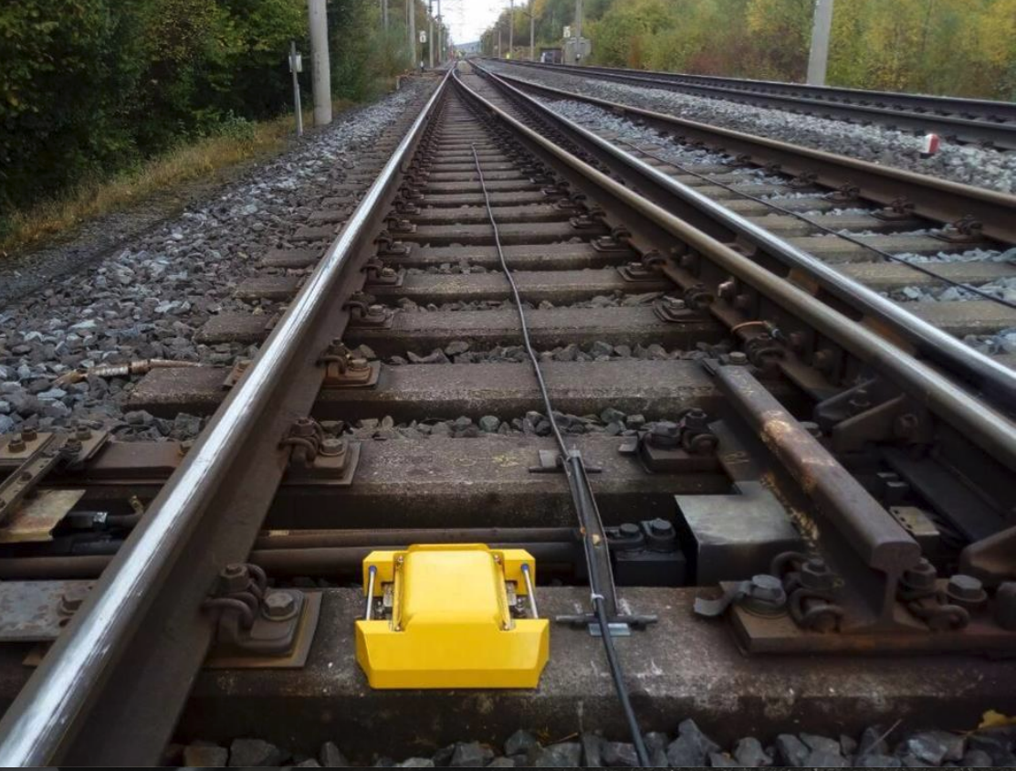
KONUX IIoT Device
Konux’s IoT device where it’s able to monitor the condition of a railway switch (Image credit: Konux)

Konux, a Munch-based deep tech AI scale-up, has been building out a SaaS business powered by proprietary sensing hardware and AI that drives a predictive maintenance software-as-a-service(SaaS) play which is upgrading railway infrastructure as reported by Techcrunch.

Its mission is to drive digitization and transformative change atop rail travel, using AI plus IoT to add intelligence to fixed rails by capturing real-time data on what’s happening on and to the railway network.

“The core problem is something that actually is a dirty problem,” says Konux CEO Adam Bonnifield as told to Techcrunch, discussing what makes this AI business different from the ones hogging most of the global limelight right now.

“It’s not one of these clean, AI model-building totally digital problems. It’s the dirty problem of getting sensors to survive the environment, extracting the data, making sense of it, fitting it within the business problems, with the customer, and then bringing along the organisation on a journey through a bunch of organisational changes.

The company is using deep tech methods and stress-tested connected hardware to gain visibility into the loads and forces railway lines are accommodating day in, and day out;  measuring vibration through the tracks to pick up anomalies that may signify failures incoming, then presenting its probabilistic analysis of what’s going to happen to the infrastructure over the next few months.

Its AI-driven predictions were developed to a 90% accuracy standard, per Bonnifield.

In addition to predictive maintenance, Konux’s AI + IoT approach supports rail operators with further business intelligence around network traffic and usage; plus support with scheduling.
It offers three products
  • Konux Switch (predictive maintenance)
  • Konux Network (usage monitoring and inspection planning)
  • Konux Traffic (smarter timetabling)

The idea is to leverage AI and IoT to power data-driven decisions that can drive optimization around other aspects of rail operation, expanding out from Konux’s first focus on tracking infrastructure stress at key points on the network.

Digital Map Library for NZ city underground pipes

0
Digital Map Library for NZ city underground pipes

Wellington City Council, New Zealand, has approved an initiative to build an updateable digital map, recording where all of the underground pipes and cables are beneath the city’s roads and footpaths. The goal is to build a system and support compliance policies that can be scaled up for the whole of New Zealand.

The Wellington Underground Asset Map (WUAM) programme will revolutionise the way buried infrastructure like Three Waters assets, telecommunications cables, gas pipes and other services are installed, maintained, operated and repaired.

The programme aims to reduce disruption to the capital’s streets by moving away from legacy records and outdated paper processes to a centralised online map-based library. It could form the start of a long journey towards a digital twin of the infrastructure under the city’s streets.

“Over the next few decades, billions of dollars will be spent on infrastructure projects around the city, including water, electricity, Let’s Get Wellington Moving, cycleways and Council capital projects like the Te Matapihi Central Library and housing developments,” said Siobhan Procter, chief infrastructure officer.

According to the council, the objective of the programme is to develop a federated data-sharing platform showing subsurface infrastructure owned by the council and other utility operators. These users will feed their data into this platform that everyone who works in the sector can access 24 hours a day, seven days a week.

“The Wellington Underground Asset Map will play a central role in making sure the variety of projects remain on track – reducing the impact on Wellingtonians and helping the city continue to function as we focus on making the city a great place to live, work and play,” added Proctor.

Teledyne e2v Space Imaging celebrates sensors success as Aeolus de-orbits

0
Teledyne e2v Space Imaging celebrates sensors success as Aeolus de-orbits

Aeolus is the fifth satellite in ESA’s Living Planet Program and has become one of the highest, impact-per-observation instruments in existence. The sensor is capable of observing Earth’s surface weather systems and into the stratosphere, 30 km high.

The data from the Aeolus satellite observations have been used to improve weather forecasts and climate models. They have also been used for tracking Saharan dust storms and enabling a better understanding of plumes from volcanoes. The Aeolus mission has paved the way for future operational meteorological satellites dedicated to studying Earth’s wind profiles.

The Teledyne team manufactured a bespoke sensor for Aeolus with a novel design specifically for this application. The sensor collects many signals from different altitudes, enabling Aeolus to measure wind speed at different heights throughout the atmosphere.

The Teledyne e2v Space Imaging team continue to specialize in bespoke detectors to meet the ever-increasing number of Earth Observation missions.

Paul Jerram, Chief Engineer, Teledyne e2v Aeolus team said, “The Teledyne Space Imaging team have enjoyed being part of this successful demonstrator mission which has far exceeded expectations. We look forward to building a detector with improved performance for the Aeolus-2 follow-up mission. We are proud to have assisted most of the world’s weather forecasting agencies in improved accuracy of long-range forecasts.”

Indian Aerospace Company Bags OMC Mapping Project

0
Indian Aerospace Company Bags OMC Mapping Project

Garuda Aerospace, India’s drone manufacturing company, has secured a substantial order of 400 Agri Kisan Drones from Indian Farmers Fertilizer Cooperative Limited (IFFCO). This achievement takes Garuda Aerospace’s order book tally to 10,000 drones for this year.

The collaboration between Garuda Aerospace and IFFCO aims to revolutionize the agricultural sector by introducing the Garuda Kisan Drone at the IFFCO Drone Yatra in the state of Karnataka. These state-of-the-art drones will enable farmers to utilize Nano Urea spraying through Precision Agriculture Drones, maximizing their efficiency and productivity.

IFFCO has launched a nationwide campaign to procure 2,500 ‘Kisan Drones’ as spray solutions for their revolutionary products, Nano Urea and Nano DAP. This ambitious initiative not only supports the development of around 5,000 rural entrepreneurs trained in drone spraying but also promotes sustainable agriculture and holistic cooperative development, contributing to the upliftment of the rural economy.

Agnishwar Jayaprakash, Founder and CEO of Garuda Aerospace,said, “Through our collaboration with IFFCO, we are revolutionizing the agricultural landscape by introducing the Garuda Kisan Drone. Our mission at Garuda Aerospace has always been to empower farmers with innovative technology, and the launch of these drones in Karnataka is a significant step towards achieving that goal. We aim to enhance crop yields, reduce costs, and promote sustainable farming practices by incorporating precision agriculture and Nano Urea spraying. We are proud to be at the forefront of this transformative journey, and we remain committed to empowering farmers with the latest advancements in drone technology.”

OpenSpace Introduces New Product for BIM Technology

0
OpenSpace Introduces New Product for BIM Technology
OpenSpace BIM+ product - BIM Element Overlay feature
OpenSpace Introduces New Product for BIM Technology
OpenSpace BIM+ product – BIM Element Overlay feature

OpenSpace, the global provider of 360° reality capture and AI-powered analytics, introduced OpenSpace BIM+, a suite of easy-to-use 3D tools that helps field teams and Virtual Design and Construction (VDC) teams get work done faster by unlocking BIM coordination on the jobsite. Announced at its Way

point customer conference, this is the third product from OpenSpace that uses technology to empower project teams to get things done faster, together. OpenSpace Capture, introduced in 2018, is used to fully document construction sites in over 93 countries, and OpenSpace Track, introduced in 2021, automatically quantifies progress on those sites. OpenSpace BIM+ adds to this portfolio with tools that accelerate BIM and field coordination workflows.

Working in both 2D drawings and 3D models is not new to OpenSpace customers. The popular BIM Compare feature in OpenSpace Capture allows field teams to navigate and compare site conditions to the project’s BIM, with the model fully aligned to the OpenSpace 360° capture. Last quarter, OpenSpace observed more than half its customers using this feature, and they represented the most active OpenSpace customers.

Neel Sheth, Vice President of Product at OpenSpace said, “Our customers’ BIM usage in OpenSpace was outpacing the industry’s overall rate of BIM adoption. That told us that OpenSpace might be able to help drive BIM utilization for those teams that are adopting and investing in BIM. With OpenSpace BIM+, we have partnered with VDC leaders and their project teams to help them work with BIM as easily as navigating a Google Street View.”

OpenSpace BIM+ is an add-on product to its popular OpenSpace Capture product, with the following capabilities:

  1. BIM analysis tools: Navigating and analyzing BIM in the field often requires the time and expertise of a VDC manager. OpenSpace BIM+ analysis tools speed up this communication by allowing field teams to easily work in the BIM and compare that to what they are building. Any project team member can click and navigate to saved views in the BIM, review model elements overlayed within the 360° photos, and access the model from any iPhone, iPad, or Android device when offline. Point cloud data can also now be stored, viewed, analyzed, and shared in OpenSpace from mobile and terrestrial laser scanners and OpenSpace’s 3D Scan feature, bringing reality capture data to one central location.
  2. BIM coordination tools: Construction projects require tremendous coordination and OpenSpace BIM+ includes features designed to help teams quickly solve problems by aligning design intent with on-site conditions to speed up responses, approvals, and project schedules. OpenSpace Capture’s popular field note feature is now part of BIM workflows with OpenSpace BIM+, allowing field teams to add detailed images and notes during site walks or back at their desks. BCF file export is also included, enabling streamlined workflows with leading BIM coordination tools like Revizto, Navisworks, and BIM Track.
  3. Seamless model management: Keeping the BIM model up-to-date can help to streamline the design and construction process, as it ensures that everyone has access to the most current information. OpenSpace BIM+ makes it easy to manage updates to the BIM with Autodesk model import, support for multiple models, and model usage reporting.

While BIM has gained widespread adoption among design and engineering professionals, its use in the field has been limited, partly due to the complexity and skills required to navigate and understand the building information model.

“With the implementation of OpenSpace BIM+, our project teams will gain the ability to swiftly address inquiries directly from the field, significantly minimizing the time-consuming exchanges they encounter while resolving challenges,” explained Breawn Felix, Regional Support Services Manager at Swinerton.

Airbus invests in new Wing Development Centre for next-gen Aircraft

0
Airbus invests in new Wing Development Centre for next-gen Aircraft

Airbus invests in new Wing Development Centre for next-gen Aircraft

Airbus is investing in its UK innovation capabilities, with the opening of a new Wing Technology Development Centre (WTDC) at its Filton site. The facility, which will be used to build and test demonstrators for a range of programmes and research projects, was opened by Nusrat Ghani, UK Minister of State at the Department for Business and Trade.

The new facility will help Airbus accelerate the design, build and testing of wings for next-generation aircraft, by using the latest technology and world-leading demonstrators to further improve the performance of its wings.

Alongside engine optimisation, making wings longer, leaner and lighter is one of the biggest opportunities to improve fuel efficiency, reduce CO2 and ultimately work towards the aviation industry’s ambition to achieve net zero carbon emissions by 2050.

Airbus Head of Filton site and Wing of Tomorrow Programme Sue Partridge explains, “The new Wing Technology Development Centre will help us to ground our research in practicality. A key element of how we deliver technology for next-generation aircraft wings is through Wing of Tomorrow (WoT), our largest research and technology programme led by the team in the UK.

“Last week, we achieved a critical milestone in the programme when our second wing demonstrator was completed by the team in Broughton, Wales and delivered to the WTDC. Here it will be prepared for structural testing in our Aerospace Integrated Research and Technology Centre (AIRTeC).”

The WoT programme allows Airbus to explore new manufacturing and assembly technologies so future generations can continue to benefit from flying.

“It is about preparing our people, technology, industrial system, supply chain and digital and physical capabilities for next-generation aircraft. We are leveraging industry partners and the very best digital tools and automation to identify potential technology bottlenecks that may slow us down in the future. The foundations we lay now will help us build better and faster when the time comes.”

The WTDC adds to Airbus’ existing research and technology footprint in the UK, including the Advanced Manufacturing Research Centre (AMRC) in Broughton and both the ZEROe Development Centre and Aerospace Integrated Research & Test Centre (AIRTeC) at its Filton site.

SpaceX Launches Euclid Space Telescope for ESA

0
SpaceX Launches Euclid Space Telescope for ESA

SpaceX Launches Euclid Space Telescope for ESA

European Space Agency (ESA) successfully launched the Euclid Space Telescope on 1st July. The telescope was lifting off from Space Launch Complex 40 at Cape Canaveral Space Force Station.

It was launched with the help of the SpaceX Falcon 9 rocket. The Falcon 9 first-stage engines burned for just over two-and-a-half minutes before stage separation and eventual ignition of the single Merlin 1D MVac second-stage engine, which performed a burn for just over five minutes.

Euclid will take a month to travel through space to its operational orbit, Lagrange Point 2. The ESA expects to share the first images later this fall. The space telescope will help in creating a 3D map of the universe. It will also be capable of seeing as far back as 10 billion light years.

What are the Different Types of Geospatial Datasets?

What are the Different Types of Geospatial Datasets?

Spatial data or Geospatial data describes any data related to or containing information about a physical object that has shape, size, and particular location on the Earth’s surface and can be represented in a geographic coordinate system. In simple words, data which is collected through physical real-life locations such as towns, cities, countries, islands, etc. is known as spatial data.

The data consists points, lines, polygons, and other geographic and geometric data primitives, which can be mapped by location, and used by a communication system to identify a particular location. By leveraging the power of geospatial data, people can make better and more informed decisions.

Types of Spatial Data

Not only location-specific information, but it also consists of other types of data like 3D Point Cloud data, LiDAR data, etc. Spatial data can be classified as:

Vector Data

Vector data is a geographical representation of the world via geometric objects such as points, lines, and polygons. A line is created by connecting points and then by connecting lines, it creates an enclosed area that is called a polygon. Vectors represent the general structure of objects on the Earth.

Raster Data

Raster data talks about multidimensional images from satellites, drones, and other kinds of camera sensors. Raster data is a data type where data is stored in matrix of pixels organized into rows and columns. It refers to imagery such as aerial photographs, imagery from satellites, digital pictures, and scanned maps.

2D Spatial Data

To identify the exact location on the Earth, a geographic coordinate system is used a two-dimensional data surface. In geometry, it is the x-axis and y-axis but in geography, it is latitude (horizontal lines that run north-south) and longitude (vertical lines that run east-west). This 2D spatial data is mainly used in floor plans. The simplest example of it is Google Maps which uses geometric spatial data to provide accurate directions.

3D Point Cloud Data and LiDAR

There is also another type of data that is called 3D point cloud and LiDAR data. To collect LiDAR data, laser light is transmitted from a transmitter to an object. The light gets reflected from the objects. In this process, the time of flight is used to develop a distance map from the object. 3D data is the data that gathered information from the real world with x, y, and z coordinates. 3D data is very helpful in providing information. It can be used to solve many problems happening on Earth’s surface. 3D and LiDAR data is used in shoreline mapping, hydrographic surveying, emergency response, and coastal vulnerability analysis.

Spatial data has a significant role to play in different domains. It helps in IoT (Internet of Things) to use remote sensing for data collection. During natural disasters, geospatial data helps to analyze which area is more affected. In transportation and logistics, it is used to analyze specific routes, make accurate time estimations, and for delivery tracking in real-time.