Home 2023 June 21

Daily Archives: 06/21/2023

Nomoko Joins the Overture Maps Foundation

0
Nomoko Joins the Overture Maps Foundation

Nomoko, a provider of real-world 3D data technology, announced today that they have joined the Overture Maps Foundation, a non-profit organization dedicated to advancing open and accessible map data, as a Contributor member.

According to a Markets and Markets report, the global 3D mapping and modelling market is expected to grow to over €6.5/$7B by 2025 as numerous industries increasingly embrace the adoption of 3D visualization technology.

Leveraging its real-world 3D modelling capabilities, Nomoko will collaborate alongside steering members, including Amazon Web Services (AWS), Meta, Microsoft, and TomTom, to create interoperable, accessible 3D datasets.

“We’re excited to welcome Nomoko to our growing community of contributors and users and look forward to working with them to create new and exciting immersive 3D mapping experiences,” adds Marc Prioleau, Executive Director of the Overture Maps Foundation. “With the addition of even more high-fidelity 3D mapping data, we are one step closer to unlocking the full potential of open, immersive and interactive mapping applications.”

Nomoko’s state-of-the-art 3D data technology captures high-resolution imagery and precise data, enabling the creation of detailed digital environments optimized for online streaming and web visualization. By integrating this expertise into the Overture Maps Foundation’s initiatives and community, Nomoko aims to support the development of open-source tools and datasets that will enable developers, researchers, and enthusiasts to build immersive and interactive applications that rely on accurate 3D maps.

“The Overture Maps Foundation’s mission comes at an important time for the mapping and visualization technology community,” said Nilson Kufus, CEO and co-founder of Nomoko. “Together, we will work towards building an open and accessible 3D data framework that will fuel innovation in various domains, including AR/VR, urban planning, infrastructure, robotics and more. By democratizing access to high-quality 3D map data, we can unlock new possibilities and empower developers, creators, and users worldwide.”

As a member, Nomoko will contribute its expertise, resources, and data to support the ongoing efforts of the Overture Maps Foundation. Together, they will collaborate on research and development projects, share technical insights, and promote adopting open standards for 3D map data.

Israeli Startup Utilises Location to Map and Discover Social Hot Spots

0
Israeli Startup Utilises Location to Map and Discover Social Hot Spots
Uriel Maslansky

Founded in 2019, Atly is a user-generated social mapping Israeli startup. It was founded by three members, Uriel Maslansky (CEO), Aviad Coppenhagen (CTO), and Joshua Kaufman (Product) after they got frustrated with the fact that mapping and finding destinations is one of the only aspects of life left untouched by user-generated content.

In an interview with Geospatial World, Uriel states, “People were trying to “feature-hack” their way through finding and saving places to go on social media platforms like Instagram and Facebook that were never meant for the discovery of location-based information, as well as suffering from out-of-date and untrustworthy results on Google Maps and other mapping and review platforms. This massive gap in how people discover new destinations and activities is what drove us to create Atly.”

Atly combines the power of social media-like knowledge sharing with mapping and location discovery tools to fuel a seamless, high-fidelity search experience that allows people to find their next favourite place. “We have over 120k users and more than 6,500 organically created map-based communities around the world,” adds Maslansky.

Excerpt

What role does location technology play in your service?

The mapping industry has gone virtually uninterrupted since 2007 when Google Maps overtook MapQuest as the dominant mapping platform. It was only in 2012 when Apple Maps was released that Google Maps had some competition, but even the largest company in the world was only able to capture about 10% market share.

Atly is all about bringing mapping up to speed with the modern world. We are rethinking mapping and focusing on being the next paradigm shift; we are bringing innovative concepts and new technology into the ecosystem by combining the wisdom of the crowd with the ease and utility of the existing finding-your-next-favorite-place platforms. Specific location technologies include a robust location recommendation system for giving people personalized exploration, and tools for creating and managing community maps. Because we are innovating what information is shown on the map, we have to deal with a lot of technological (or algorithmic) problems that nobody has had to solve before. For example, each Atly user will see a different map based on the specific maps they join, filter tags, or searches, requiring advanced technology for live rendering of maps.

Atly has a much larger vision of becoming the de facto platform among the younger generation for discovering their next favourite place.

With so many issues of data theft and data misused, how do you ensure the authenticity of the user data and how do you ensure the user data be protected?

The beauty of the user-generated content that makes up our communities is that the recommendations are validated by the wisdom of the crowd, reflecting trustworthy information. On top of that, all of our map-based communities are controlled by community managers that take care of the quality of the data.

Regarding data privacy, keeping our users’ data secure is a cornerstone of our development process. We stay up to date and meet the latest standards widely accepted for development in order to protect our users and their data.

Recently, Atly announced its official launch with $18 million in funding from Target Global, Tal Ventures, and FKA Brands. How do you plan to utilize the funding? What are your plans for the next 5-10 years?

Our recent funding will enable us to continue improving Atly’s state-of-the-art algorithms and overall performance, to release much anticipated product features and updates, and to collaborate with additional creators. We are also currently growing our US user base, on an individual city by city basis.

There are numerous product features that will be rolling out throughout the end of this quarter. These features will include new discovery capabilities, updates to the maps that better highlight the number of recommendations a place has received, connect users to their friends’ recommendations, and monetization tools to promote map monetization for creators.

Over the next five to ten years, we plan to grow Atly into the one-stop-shop for all location-based needs, while continuing to provide the most trusted and authentic, user-generated and live content from those who know these spaces best.

The Future of Asset Management

0
The Future of Asset Management

In the world of telecoms and utilities, geospatial asset management and enterprise asset management systems are indispensable. While geospatial solutions keep track of asset locations and interconnections (relationships), EAM systems help to manage asset conditions and maintenance processes.

Those systems need to work together but they are separate and extremely complex. To marry them means a very expensive wedding. In fact, the cost of integrating geospatial and EAM systems can be larger than the sum cost of both systems. Once integrated, the databases that each system pulls from must match completely.

For instance, an EAM will create a work order, and the geospatial system links all the designs and asset data needed for that work order. If the integration breaks down and the work order is lost, so is the accompanying design and planning work. Such a failure costs time and money to re-engineer.

Just keeping the databases of the two systems aligned is a difficult job, when contractor plans don’t necessarily match the as-built infrastructure and maintenance reports from the field aren’t always timely or complete. On average, the data matches only 80 percent of the time.

Utilities and telecoms have long devoted in-house resources to knitting these two indispensable systems into one and keeping them both running and compatible, with continual software patches and database synchronization. However, the job of these companies is to maintain their physical networks, not their IT interfaces. The additional work of maintaining separate, but integrated systems is a distraction from their core business.

Moving forward, the industry needs to focus on comprehensive asset lifecycle management through a “smartEAM” approach – one system to govern asset locations, attributes, conditions and work processes. With a smartEAM system, operators could pull from a single database for planning, design, construction, maintenance and more.

Say an electric utility wanted to determine where to build the next substation on its grid to maximize the efficiency of powering homes in a growing area. A smart EAM could aid in planning and designing the network and calculating the cost of the materials, labor and other necessities of construction. The same goes for a telecom making plans to expand its fiber optic network.

In addition to adding efficiency, a smart EAM system would significantly reduce the total cost of ownership, since the owner would be dealing with just one system instead of two. It would save the cost of employing experts to maintain two separate, complex systems with separate interfaces. And it could help lower maintenance and support costs.

In the age of digital transformation, companies need to consider not only which data and systems to move from physical to digital, but also how to improve their legacy IT. By breaking down the silos between geospatial asset management and enterprise asset management, a smart EAM can deliver the much-needed “single source of truth” for lifecycle asset management that can transform planning and operations.

Improving Urban Liveability using Geospatial Technologies

Improving Urban Liveability using Geospatial Technologies

The Smart Cities Mission aimed at driving financial development and improving citizen satisfaction through exhaustive work on the friendly, monetary, physical, and institutional strengths of the city. The attention was on manageable and comprehensive advancement by the formation of replicable models.

The vision was to encourage urban communities that give better infrastructure, clean surroundings, and economical livelihood and provide satisfaction to their residents through ‘smart solutions’.

Stakeholders involved

Smart Cities Mission authorities, municipal corporations, urban local bodies, urban planners, department officials, project management consultants, master system integrators, and citizens.

Solution and Implementation Plan

Road Network Analysis Module
Disaster Response Module
Capital Project Monitoring Module

GIS-based planning helped the department to plan utilities strategically so that the maximum number of citizens can be served at optimal cost. The property tagging feature helped departments identify unassessed properties, resulting in a property tax collection increase. GIS also helped the department to improve traffic movement for less congestion in peak hours.

Citizen services have become a lot easier with GIS information as it helped the department to exactly know about the citizens’ location and their requirements and it led to quick resolution of required services.

GIS-based multi-criteria decision-making support has led many departments in spatially selecting sites for city utility planning and asset management.

TELUS, ÉTS & iBwave to transform telecom industries with 5G

0
TELUS, ÉTS & iBwave to transform telecom industries with 5G

TELUS announces that it has signed an agreement with the École de Technologie Supérieure (ÉTS) and iBwave, a Montreal-based software developer and a company that deals with the deployment of indoor wireless networks. The collaboration includes the development of a 5G laboratory at ÉTS, which will serve as a meeting place for researchers, students and companies to drive innovation in telecommunications, construction, engineering and architecture through fifth-generation networks.

This agreement is part of TELUS’ nearly $30 million in investments in Montreal in 2023 to deploy and update its 5G and optical fibre networks in the city.

More specifically, TELUS, ÉTS and iBwave will combine their expertise to re-imagine how wireless networks inside buildings are designed and deployed as part of large architecture and construction projects, drawing on the concept of Building Information Modelling (BIM).

This approach centralizes all of a project’s data and all of a building’s characteristics in a single 3D digital representation to help improve collaboration between the various stakeholders, reduce errors and facilitate decision-making.

Because many construction materials and components used in the design of large office, academic and hospital buildings have a significant impact on mobile signals, the BIM concept will make it possible to more accurately predict wireless service performance in connection with large construction projects and to plan for 5G network deployment in collaboration with all stakeholders, in much the same way as for plumbing, electrical and HVAC systems.

“This agreement with ÉTS and iBwave allows us to use technology to connect Montreal’s businesses, universities and creative minds to stimulate innovation and the digital transformation of the construction industry,” explains Nazim Benhadid, senior vice-president at TELUS. “The research done in the 5G lab at ÉTS will support innovation to optimize network performance at important sites like universities and healthcare centres. Ultimately, improved connectivity means that schools will be able to use the latest immersive technologies to help students learn, business operations will be more energy-efficient, and healthcare professionals will be able to communicate more effectively.”

“ÉTS is pleased to take this first step in a collaborative project that will draw on the rich expertise of our professors and our recognized capabilities in areas at the cutting edge of research and technology, including sensors, networks and connectivity, intelligent and autonomous systems, and built environments,” said Ghyslain Gagnon, Dean of Research at the École de Technologie Supérieure. “This new living laboratory adds to our collaborative ecosystem for research and learning in real environments, developing concrete solutions in areas of strategic interest for the industry.”

“The partnership with TELUS and ÉTS is an exciting opportunity to promote innovation and digital transformation in the construction industry,” says Louis Jacob, senior vice president and CTO at iBwave. “By drawing on our expertise and integrating Building Information Modelling (BIM), we hope to revolutionize the way wireless networks are designed and deployed in large-scale projects. This collaboration will make it possible to improve connectivity at critical sites and facilitate advances in education, energy efficiency and transparent communication between healthcare professionals. We’re excited to be a part of this adventure, and to contribute to the positive impact it will have on the industry.”

City Labs unveils Tritium-Based Technology to Power NASA Missions

0
City Labs unveils Tritium-Based Technology to Power NASA Missions
City Labs
City Labs unveils Tritium-Based Technology
City Labs

City Labs, a Florida-based manufacturer of tritium power sources, has announced the successful completion of a two-year effort that has culminated in the delivery of a next-generation tritium-based space power source to researchers at the National Aeronautics and Space Administration (NASA). This achievement embodies City Labs’ commitment to pioneering advancements in nuclear micropower solutions.

The delivery of this prototype not only highlights NASA’s keen interest in micropower sources but also acknowledges their confidence in CityLabs as a pioneering force in delivering micropower capabilities for space-based missions to the lunar surface and beyond. City Labs is honored for the opportunity to demonstrate their technology and contribute to the ongoing national and global endeavor to establish a continuous presence in space.

The newly developed tritium-based power source is a collaborative effort between the talented team at City Labs and its many partners across the United States, leveraging diverse expertise to achieve groundbreaking innovation at the forefront of micro power sources.

Rocket Factory Augsburg to launch from Kourou Space Center

0
Rocket Factory Augsburg to launch from Kourou Space Center


Launch service provider Rocket Factory Augsburg AG (RFA) has signed a binding term sheet with the French space agency CNES to offer its launch services from the Kourou Space Center (CSG) in French Guiana. RFA will launch from the ELM-Diamant launch complex in 2025.

With access to arguably the European spaceport, launch service provider RFA will be able to offer customers all inclinations from equatorial to polar. This expands RFA’s portfolio of orbits available to customers to include low inclination orbits such as GTO, MEO, GEO, lunar and even interplanetary mission profiles.

As a result, even more flexible and precise servicing of all types of missions for Earth observation, connectivity, or even entire constellations are possible. As part of CNES’ open tender process to open the Kourou Space Center (CSG) to commercial launch service providers, RFA ONE will launch from CSG starting in 2025.

In addition to the successful completion of the first European upper stage test of its kind in May 2023, RFA also confirms its commercial leadership position by securing the ELM-Diamant launch complex.

With this second launch pad from RFA, the company will be able to deliver all mission profiles for ESA and its member states as institutional customers.

“By securing a launch site at the Diamant launch complex, this agreement allows RFA to offer GTO, MEO, GEO and even lunar and interplanetary flight profiles to its customers. By launching from Kourou, the European Spaceport, we can serve ESA and its member states as institutional customers for any mission profile they desire. Together with our successful upper stage hot fire test – a first in Europe – we have once again confirmed our technical and commercial leadership position in Europe,” said Jörn Spurmann, Chief Commercial Officer at RFA.

“Just before the final launch of Ariane 5, this collaboration is a clear commitment to the future of European spaceflight from Kourou. We are very proud to launch from the historic Diamant launch site, where European spaceflight began its long and successful history. We look forward to continuing it.”

“CNES is proud to sign this agreement with RFA, which confirms RFA’s decision to launch from the ELM Diamond site at CSG’s European Spaceport,” said Dr. Paolo Baiocco, senior project manager for micro-mini launchers at CNES. “We look forward to working with RFA to further develop launch activities in Kourou. This is an important step for European spaceflight.”

Until now, the launch pad in Kourou has only been used by CNES for its Diamant rocket in the 1970s. Now the launch complex is to be given a new purpose, in the tradition of opening access to space through innovative and groundbreaking ventures.

As such, RFA is one of the first NewSpace companies to be given the opportunity to use it. The new launch pad will be upgraded and equipped in the coming years with the aim of being used for launches from 2025.

OneSky, Ansys collaborate for Advanced Air Mobility Solutions

0
OneSky, Ansys collaborate for Advanced Air Mobility Solutions
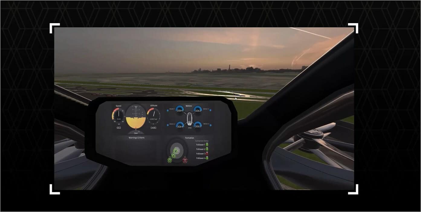
High-fidelity electric vertical take-off and landing (eVTOL) simulation for Cockpit Display System validation
OneSky, Ansys collaborate for AI-Based Advanced Air Mobility Solutions
High-fidelity electric vertical take-off and landing (eVTOL) simulation for Cockpit Display System validation

OneSky Systems and Ansys are collaborating to progress autonomy in advanced air mobility (AAM) solutions. OneSky is providing its technology integrated with Ansys’ solutions to develop artificial intelligence (AI)-based software equipped with perception and decision-making software.

The collaboration enables OneSky and Ansys AAM customers to train and validate neural networks (NN) with mission-driven simulation to significantly reduce the risk, time, and costs associated with physical testing required for airworthiness certification. The software accelerates and enhances the development, validation, and certification processes of autonomous AAM transport systems.

OneSky combines its operations simulation and flight planning methodologies with Ansys’ autonomy solution to strengthen the fidelity of its systems-level simulations. This integrated solution provides aircraft developers and suppliers with end-to-end workflow solutions to help ensure unmanned aircraft systems (UAS) are safe, efficient, compliant, and scalable from one vehicle to a full fleet. From the concept of operations (ConOps) to mission validation, the integrated Ansys and OneSky solutions allow customers to safely train, test, and validate critical UAS and AAM applications, building confidence around AI-based software and autonomy in embedded systems.

“The integrated Ansys and OneSky solutions provide customers with a vast and thorough digital simulation range where we can position systems, supporting infrastructures, and simulations in a safety-critical space to analyze before building prototypes or physically flying in the airspace,” said Bob Hammett, CEO at OneSky.

Leveraging Ansys’ model-based environment and OneSky (authoritative) airspace modeling, customers can drive the analysis, development, and airworthiness certification of autonomous software for AAM applications. Combining high-fidelity simulation and digital mission engineering helps enable customers to develop and validate systems in action against mission and agency requirements. Digital mission engineering expands simulation from a static model to an interactive model of the operational environment, which is critical in accurately predicting and validating the behavior of autonomous systems.

Delivering Innovative Geospatial Solutions Across Sectors

Delivering Innovative Geospatial Solutions Across Sectors
iSpatial Techno Solutions at GWF 2023

We started with a vision of delivering innovative smart solutions for solving customer challenges by applying location intelligence, AI, and geo-analytics for smart cities and spatial data infrastructure programs, sustainability, and the environment. We also work with the oil & gas sector to solve operational challenges. We are a system integrator who are able to understand client pain points and identify the right source of information to provide end-to-end solutions. We are always focusing on innovation, finding the right opportunities, and delivering better values to our customers, says Vattem Narendra Babu, CEO, iSpatial Techno Solutions.

BIRD Aerosystems and ČLS announce Cooperation for AMPS

0
BIRD Aerosystems and ČLS announce Cooperation for AMPS

BIRD Aerosystems and ČLS announce Cooperation for AMPS

BIRD Aerosystems, a provider of defense technology and solutions, and land fleets of governments and related agencies, and Česká letecká servisní (ČLS), a division of CSG Aerospace that specializes in the integration and modernization of avionics systems, announced cooperation aimed at expanding their joint marketing efforts and meeting the increasing demand for advanced airborne missile protection systems (AMPS) in Central Europe.

The strategic cooperation arrives after the two companies have already joined forces on several successful projects, where BIRD’s AMPS airborne missile protection systems, including the SPREOS DIRCM, were provided and installed on aircraft of European customers. By joining forces, both companies aim to strengthen their presence in the European market, expand their customer base, and effectively address the high demand for airborne missile protection systems in Central Europe.

BIRD’s AMPS Airborne Missile Protection System provides the most enhanced protection for military and civilian aircraft against the growing threat of ground-to-air missiles (MANPADS). The system is designed to automatically detect, verify, and foil SAM attacks through the effective use of countermeasure decoys (Flares and Chaff) and Directional Infrared Countermeasures (DIRCM) that jam the missile’s IR seeker and protect the aircraft.