Earth observation (EO) is a valuable tool for city planning and in transitioning them to become smart, well connected and climate neutral cities. EO provides essential data from mapping green spaces to monitoring local climate, air quality and the overall wellbeing of citizens, which is then utilised by government bodies to make informed decisions.
Recently, Veritas Imagery Services and NOKTOsat are collaborating to provide a new commercial application of EO satellite imagery to local government departments of Spain, which will allow them to better monitor and manage their street lighting networks, as they combat rising energy prices.
Paul Majmader, CEO of Veritas Imagery Services says, “This is an excellent example of how Earth Observation imagery from space is drastically improving current methods of providing information on our environment. Using unique data sources and processing techniques, we are providing a service that would otherwise not be possible at such a modest cost point. We are excited by the many applications that this approach will unlock.”
How EO data helps
Images from space provide unique insights over vast swaths of the earth’s surface and even for the largest of urban sprawls, only one or two might be needed to scrutinise a council’s entire lighting network.
However, most satellites collect their images by using the reflected light of the sun, something that is in short supply during the night and many satellites cannot ‘see’ objects as small as lampposts.
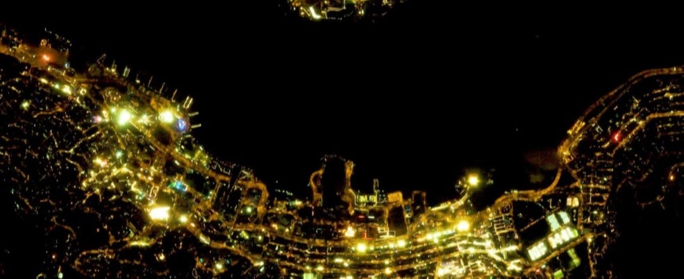
Now, advanced imaging and processing techniques are being used with data collected from space, to provide a commercial solution to this problem. Imagery from the Jilin-1 constellation provides pixel sizes of 50cm, which can be used pinpoint the location and spill of lighting sources.
Over the last two years, these images have been used successfully to monitor the night-time public lighting in Madrid and have provided a completely new way of monitoring and managing this essential resource in Spain’s capital city.
To highlight the power of the results, the team uploaded images of central Madrid before the 2021 Christmas holidays and during them, when many extra lights were hung on buildings and across streets.
Image of Madrid at night | Veritas Imagery Service
EO images show just how easy it now is for the lighting managers to monitor the network, better balance the amount of available lighting and quickly see the areas where problems have developed.
Madrid at night from space | Veritas Imagery Services
Measuring and mapping current lighting systems from space can help plan the smarter use of communal lighting, reduce energy consumption and minimise the impact of light pollution in a time of ever-increasing costs.
Addressing Challenges
Energy distribution has become a big challenge considering the soaring cost of energy and limitation of natural resources. The organisations that provide the public with a wide range of vital services, face ever-increasing bills to keep their streets lit at night.
To address this challenge, local municipalities around Europe and beyond have either started or are planning to reduce the number of hours they keep their streetlights burning during the hours of darkness.
To overcome the challenges, managers are looking for innovations and technology to adopt flexible and smart lighting practices that reduce consumption of power whilst still providing the reassurance of lit areas. Many councils are converting older lights to use LEDs.
Local governments and managers are trying to find it impossible to target those areas that they must keep illuminated and those where they can safely, reduce the number or strength of the lights that they keep on.
Veritas Imagery Services for various projects
Veritas Imagery Services operates mainly with Electro Optical satellites delivering very high-resolution imagery. Each sensor has unique capabilities, which one (or combination) to use will depend on the application and project requirements.
Using frame imager capability, these satellites are able to effectively increase the exposure time therefore allowing enough light to the sensor to record highly detailed nighttime imagery. This allows identification of individual street lights and is opening up an entirely new range of applications.