
Globally, the effects of climate change are already being observed through increases in drought, forest fires, sea level rise, flooding, and hunger. Given the vulnerability of Pacific Island countries and territories (PICTs) in this respect, the Pacific region faces unique challenges in managing natural resources and biodiversity, securing economies and livelihoods and ensuring sustainable food systems. More disaggregated, real-time, and scalable data and technology is needed to ensure effective decision-making, policy enablement, and action, especially against the existential threat that climate change poses for the Blue Pacific Continent.
We are living in an era where access to data and technology is becoming cheaper, more accessible and with greater processing power than ever before. Coined as the Fourth Industrial Revolution (4IR), or in the context of the Sustainable Development Goals (SDGs), the data revolution for sustainable development, the advancement of cloud computing, machine learning and AI, sensors and standards is allowing geospatial and Earth observation data to scale at an unprecedented rate. New satellites enter Earth’s orbit monthly providing information on everything from communications, defense, and security to carbon emissions, weather, water quality, and land use patterns. However, even with these breakthroughs, there is still a gap in providing access to these data in the right form and quality such that it can be useful based on the needs and priorities for the countries it is meant to serve.
The Pacific Community (SPC) initiated Phase I of Digital Earth Pacific to engage stakeholders, conduct a needs assessment, develop use cases and a prototype infrastructure, and use this experience and outcomes to develop a business case for making free, open and operational satellite data available for the region. The approach to develop the Digital Earth Pacific program is based on prior experience with the Digital Earth Australia and Africa (see below) programs. Digital Earth Pacific will be a regional public good making analysis ready Earth observation data freely and openly accessible to users across Pacific Island Countries and Territories. Open algorithms and analytical capabilities will further enable SPC, governments, academic and research institutions, civil society and the private sector to create data products and services to support growth for entire economies, decision-making for research, national development priorities, and sustainable development.
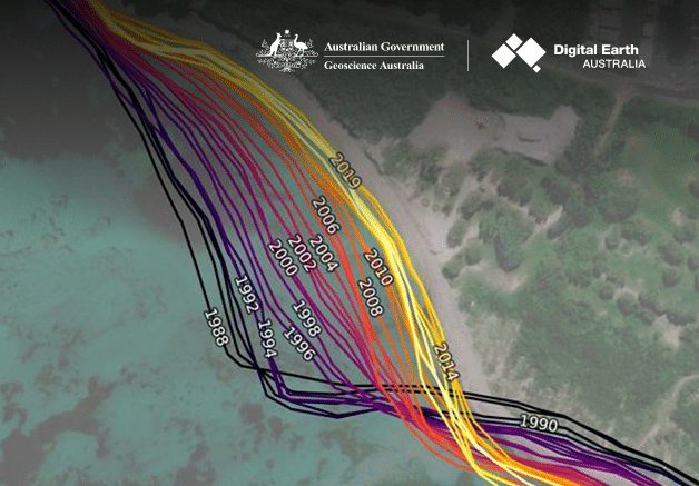
Digital Earth Pacific will provide a fundamental digital infrastructure that will ensure every nation in the Pacific has access to tools and technologies to routinely monitor and track challenges such as coastal inundation, coral bleaching events, illegal fishing, and other ocean related issues through robust decision-ready products. The system condenses years of freely available datasets to provide real-time understanding on issues such as how disasters have changed coastlines, the impact climate-change is having on lagoon health, where hot spots for wave energy are located, and to combine weather outlooks and agricultural production for farmers across countries.
Digital Earth Pacific will become an operational public good that will routinely generate products from this data with every satellite overpass. Pacific island countries and territories will be able to access the information the same way weather reports are accessed on mobile phones, any time on any day of the week.
While previous work had been conducted by SPC through consultations with member countries on the concept of a Digital Earth Pacific program, the first phase of this focused effort kicked off in March 2021. The key objectives were the following:
An Interim Steering Group (ISG) was established in April 2021 inclusive of member countries, international organizations, universities, and research institutions. The mandate for the ISG was to provide overall strategic guidance and expertise in support for the successful implementation of Phase I of Digital Earth Pacific. The ISG provided both political and technical guidance, and most importantly, allowed for engagement with member countries in the lead up to the national workshops to better understand needs and priorities. The ISG also offered an opportunity to align where needed with existing programs and initiatives, and seek international support based on project needs and requirements. Members of the ISG included:
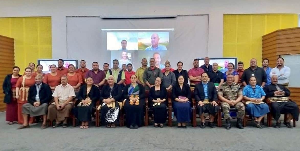
A key driver for Phase I was to develop a national consultation process with the pilot countries to raise awareness around the intent of the Digital Earth Pacific program and use these events as a key opportunity to engage and identify needs and priorities. A whole-of-government and multi-stakeholder approach was developed where SPC worked with each host country (Republic of Marshall Islands, Vanuatu, Tonga, and Fiji) to develop the agenda and identify the participants. The national workshops were designed to be interactive with ministries and other stakeholders having the opportunity to speak to work they are doing and what they think is most important moving forward. In this way, it also gave participants an opportunity to hear from their peers and align and collaborate where possible.
The national workshops led to the development of a needs assessment report (see link for full report). Needs and priorities identified by each country were translated into a set of use cases that indicate the purpose for how data served by Digital Earth Pacific could be used. These serve as the basis for understanding and prioritizing products and services to be developed for the region.

The national workshops led to the development of a needs assessment report (see link for full report). Needs and priorities identified by each country were translated into a set of use cases that indicate the purpose for how data served by Digital Earth Pacific could be used. These serve as the basis for understanding and prioritizing products and services to be developed for the region.

Doubling agriculture productivity for small-scale producers increases national resilience and often meager farmer incomes. In some countries, automation will reduce costs, but the greatest benefits will be accrued with better knowledge for smallholders. The knowledge that enables a holistic approach to improve the whole crop production system on and within a specific holding.
Small-scale producers do not want to be flooded with data and technology, which 90 percent cannot finance in any case. Complexity is being removed, and tools provide small-holding level understanding to support decision making, from soil preparation to selling harvests based on predicted yields. Businesses can play a significant role in creating easily accessible services for smartphones. The heavy lifting of integrating and analyzing data is hidden from the user.
Governments can support this with open high-resolution soils and hydrometeorology data consumed directly by smallholders or the companies providing services to them. Earth Observation supports crop monitoring and yield prediction, with ground truth from farmers resulting in improved modeling. Current revisit challenges will evaporate as more sensors are available in space.
Good land registration and land boundaries data, coupled with the ability to monitor production remotely, will reduce the risk of loans to farmers. And, excitingly, better enable the fledgling carbon sequestration industry.
A Minimum Viable Product (MVP) was developed to demonstrate the capabilities of a cloud-based, digital infrastructure serving Earth observation data, products and services for the Pacific. At a minimum, the MVP was to:
For the prototype, Microsoft’s Planetary Computer was chosen to “power” Digital Earth Pacific. The Planetary Computer combines a multi-petabyte catalogue of global environmental data with intuitive Application Programming Interface (APIs), a flexible scientific environment that allows users to answer global questions about that data, and applications that put those answers in the hands of conservation stakeholders. Most importantly, the Planetary Computer is completely open-source and can be set up so that the host institution can maintain control over user authentication and make its own data, products, and services available. Additional specifications also made the Planetary Computer attractive including its indexing and search capabilities using the STAC API, focus on usability and front-end, and the types of data available or planned.

The map viewer provides the general public with an easy-to-use interface to explore the geospatial and Earth observation data provided by Digital Earth Pacific. This includes those data that are made available by the Planetary Computer, as well as derived datasets developed by SPC and its partners.
Jupyter notebooks provide the product development environment to access, manipulate, and run algorithms. Notebooks allow for general analysis needs (e.g. NDVI, cloud masking, vegetation change) and more specific, use-case oriented applications (e.g. water observations from space (WOfS), coastline change, crop extent or urban extent). The notebook environment is based on Pangeo, which is an open-source community effort to develop software for big data geoscience research and applications. A staging and production environment allows for testing new algorithms and publishing tested notebooks for broader consumption.
Digital Earth Pacific will be implemented using a demand-driven approach that focuses on country-level needs and priorities, and deploys a user-centric, co-design approach in the development of products and services to ensure they are fit-for-purpose. This ensures that the manner in which Digital Earth Pacific develops is not supply-drive, or “build it and they will come”, but rather based on the priorities of PICTs. This requires an engagement and development process that builds technology incrementally based on direct feedback from users and adjusts as necessary – a process of engagement that happens with users internal to SPC and those external.
Most importantly, strong engagement, communications and outreach is needed to build trust and relationships with Member Countries and other stakeholders across sectors. When possible, local expertise should be leveraged, assumptions tested and then iterated to build solutions that are agile and fit for purpose.
SPC as the principal scientific and technical organization in the Pacific region since 1947 will serve as the institutional home for Digital Earth Pacific. SPC will work with stakeholders across the region to establish Digital Earth Pacific through demand-driven, user-centric design approaches that focus on user engagement to understand the needs, priorities, and capacity of the region. This will require an emphasis on communications, outreach and engagement, and creating strong, multi-stakeholder partnerships where finance, data, technology, and expertise can be leveraged and scaled to deliver the outcomes of the program.
There will be a strong focus on capacity development for the region. While SPC will support the development of data services and products, it will do so through co-creation of these products by working with staff from government agencies seconded to SPC. This will provide a holistic, on-the-job training mechanism over a 6 month to one year period where each trainee can then return to their country with increased capacity and also provide further training in-country. SPC will also work with member countries on the uptake and usage of data products and services to inform policy and decision-making.
To ensure buy-in from both a top-down and bottom-up approach, the existing governance structure will be strengthened into both strategic advisory and technical advisory mechanisms. Again, this will be a multi-stakeholder approach, but most importantly, inclusive of member countries and institutions based in the Pacific. This will ensure alignment and the development of a responsive work program.
A phased approach for establishing and growing the Digital Earth Pacific program through the 2030 timeframe is proposed. The roadmap is presented according to three phases:

To find out more about the Digital Earth Pacific Program, visit:
https://www.spc.int/DigitalEarthPacific
https://news.microsoft.com/apac/features/digital-earth-pacific/
© Geospatial Media and Communications. All Rights Reserved.