In this exclusive interview, we engage with Dr. Pakorn Apaphant, the Executive Director of GISTDA. As the leader of the agency responsible for advancing space technology and geoinformatics applications, Dr. Apaphant sheds light on how satellite data serves as a pivotal tool for socio-economic growth in Thailand.
What are the key opportunities in leveraging satellite data for driving socio-economic development in Thailand?
As the top exporter of agricultural products and processed agricultural products in the world, the Thai government has prioritized addressing climate change, which has led to natural disasters such as flooding and droughts, directly impacting agricultural products.
Multiple satellite data sources are combined for crop area assessment, crop classification, crop health evaluation, and yield prediction. The application of space technology in agricultural management aims to reduce costs, increase crop yields, and enhance the economic productivity of the country’s agricultural sector, which contributes to economic stability and an improved quality of life for farming families.
GISTDA has developed an agricultural application called ‘Dragonfly’ to offer farmers the opportunity to save money, earn more, and reduce their environmental impact by using this knowledge.
This will boost farmers’ incomes and food security, leading to better environmental protection and more sustainable agricultural practices, ultimately ensuring sustainability for our country.
Furthermore, GISTDA has initiated a project called ‘AIP Climate-Resilient Agriculture’ to assess the impact of climate change on rice production.
This project involves strategic partnerships with organizations such as the Office of Agricultural Economics, the Department of Agriculture, the Rice Department, the Department of Climate Change and Environment, the Office of Natural Resources and Environmental Policy and Planning, and Ramkhamhaeng University.
What have been the challenges in utilizing satellite data, and how would you approach addressing them in your role?
Leveraging satellite data for driving country development in Thailand presents several key challenges. First, ‘data accessibility’ is a fundamental issue. Many government agencies, businesses, and research institutions face difficulties due to limited resources and technical expertise in accessing and utilizing satellite data effectively.
Second, ‘technical capacity’ includes expertise in data analysis, interpretation, and the development of relevant applications.
Third, ‘data integration’ is often complex due to varying formats and standards among different datasets. Ensuring seamless integration is crucial for deriving meaningful insights.
The last challenge is ‘infrastructure.’ Building and maintaining the necessary infrastructure for data reception, processing, and storage can be resource-intensive.
GISTDA, as a core government agency in space and geo-informatics, initiates a project called ‘sphere,’ which will serve as a gateway to a world of geospatial intelligence and satellite data.
Sphere is GISTDA’s cutting-edge open geospatial intelligence platform, designed to empower individuals, organizations, and government agencies with a powerful suite of tools and data resources. It brings the world’s geospatial data to your fingertips.
This cloud-based platform provides shared and trusted geospatial data, services, and applications, such as base maps, crop datasets, map APIs, and map makers, among others, based on the FAIR principle, derived from ‘Fair, Accessible, Interoperable, and Reusable.’ We hope that Sphere might be a game-changer in the field of geospatial intelligence in Thailand.
How do you envision the integration of emerging technologies such as AI and Machine Learning shaping the future of satellite data?
The integration of AI, Machine Learning, and satellite constellations is exciting. AI algorithms can process data from constellations in real-time, rapidly detecting environmental changes. For example, they can monitor crop health and track illegal fishing activities.
This synergy allows for quick response and intervention, making our sustainability efforts more effective. These technologies enhance data accuracy, cost-effectiveness, and timeliness.
By leveraging AI, GISTDA can analyze satellite data more effectively, identify environmental changes rapidly, and develop early warning systems for disasters. Customized solutions tailored to Thailand’s unique challenges, capacity building, and open data initiatives further contribute to advancing sustainability practices and promoting informed decision-making.
One of the projects undertaken by GISTDA involves the utilization of Machine Learning techniques to assess carbon credits. This is achieved through the identification of aboveground biomass.
Machine Learning leverages training datasets that incorporate multiple variables to generate models to estimate CO2 emissions and removals. This technique is very useful for monitoring climate change effects, vegetation responses, and agricultural applications.
Thailand is exposed to various natural disasters. How can satellite data and related solutions be utilized to address these challenges?
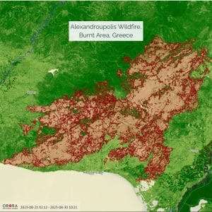
GISTDA has employed satellite technology to monitor and respond to disasters. In cases of floods, forest fires, and droughts, satellite imagery provides real-time information, aiding in disaster preparedness, evacuations, and relief efforts. This has reduced the extent of the damage and enabled rescue preparation, which has saved lives.
Currently, GISTDA develops and provides disaster applications on website for monitoring floods, forest fires, and droughts. These applications leverage satellite data, which is collected and analyzed daily and semi-automatically to determine the extent of the affected areas.
Subsequently, we develop a predictive model for forecasting such scenarios and make it accessible to the public through an application. The government sector is the primary client because they are the ones who apply this information to their daily duties.
GISTDA also provides satellite data for the public in emergency situations.
What key lessons have you drawn from these use cases that may be applicable to broader sustainability efforts?
- Customized Solutions: Customizing satellite solutions to meet Thailand’s unique environmental issues has been essential. GISTDA enhances its efficacy by adapting technology to local requirements.
- Capacity Building and Training: Training and education initiatives provided by GISTDA have improved the ability of local organizations and individuals to make use of satellite data. This approach has led to improved sustainability efforts.
- Timely Data Sharing and Collaboration: We collaborate with all parties to ensure that individuals have equal access to data. Furthermore, open data policies, as feasible, promote satellite images and insights to enhance transparency, increase public awareness and cooperation, and boost sustainability.
- Collaboration with partners is also crucial for our future mission. Partnering with other satellite data providers will be beneficial in conjunction with THEOS-2 to deliver and provide additional data to the public. By working closely with partners, we can access advanced satellite data, share valuable insights, and combine our strengths to tackle complex challenges such as environmental monitoring, resource management, and conservation efforts more efficiently and comprehensively. This collaborative approach not only enhances our capabilities but also underscores our commitment to addressing critical global issues through innovation and cooperation.