Not When, but Where

Location Intelligence not only helps emergency personnel in responding better to a situation, but can also empower them to assess future events and be prepared for them.

Picture of By Meenal Dhande
By Meenal Dhande

Senior Assistant Editor | Defence & Intelligence

Emergencies mostly occur when they are least expected. Perhaps that is why, more often than not, the response is reactive, focused around damage control, not prevention. While certain occurrences cannot be predicted, they can certainly be handled well with the knowledge of ‘where’. For instance, in case of a pandemic like the one we are currently battling, knowing where the virus came from and where all it is spreading can be a game changer for emergency responders in terms of channelizing resources and making fact-based decisions. This is where Location Intelligence (LI) comes in.

“When harnessed for preparedness and mitigation efforts, knowing where a community faces the greatest risk, where residents are most vulnerable, and where critical infrastructure is located allows planners to design risk-informed projects that can reduce risk and help mitigate the impacts of these hazards. Putting it all together, Location Intelligence means better understanding of systemic risk, and the ability to anticipate and respond effectively at the moment,” explains Ryan Lanclos, Director of Public Safety Solutions, Esri.

There are those who argue that emergency service professionals do not necessarily need to know all about ‘where’, but Kalyn Sims, Chief Technology Officer, Safety & Infrastructure at Hexagon, disagrees. She says, “LI touches most, if not all public safety planning and operations. For example, analysts examine crimes by location so police can deploy resources effectively. Fire departments build new stations based on geographic coverage areas. Dispatch centers geofence areas to segment calls for service during special events. The list goes on.” Sharing similar thoughts, Dr. Shirish Kumar Ravan, Senior Program Officer, UNOOSA, and Head of UN-SPIDER Beijing Office, says, “LI coupled with geospatial intelligence offers a great tool for emergency response as it enables near-real-time assessment of the emergency. For example, during the Covid pandemic, LI provided tools for tracking the infection and studying dynamics related to mass migration induced due to lockdowns in big cities.”

Emergency management

Location has forever been at the heart of emergency management. However, technological developments and the location awareness among people in recent years have changed how governments and other organizations respond to emergencies. Let’s take a look at how the power of location is transforming modern-day emergency response.

Healthcare
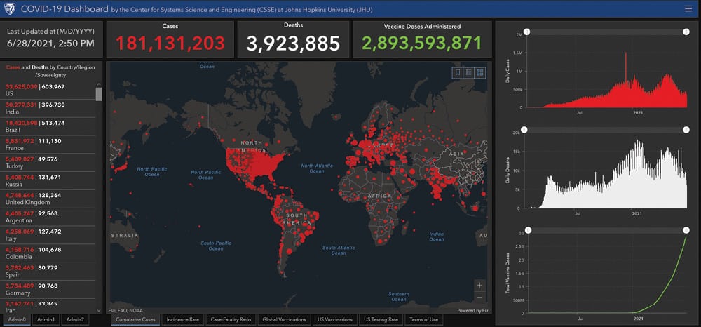
Since the outbreak of COVID-19, governments and healthcare providers have relied on geospatial and location technologies for real-time visualization, data sharing, analysis, planning, etc. “The pandemic dominated the efforts of so many in the emergency management field. It’s difficult to consider anything during such a situation as success, but it was LI that led to Johns Hopkins University and other authorities track cases worldwide in an easy to navigate dashboard to show where the virus was taking hold each step of the way, helping those regions and governments decide how to react,” says Lanclos. LI was at the center of numerous local vaccination deployments. In Arizona’s Maricopa County, the municipality surveyed residents on their likelihood of getting a vaccine to dedicate resources where they were needed most. When officials noticed a particular zip code had fallen behind in inoculations, they opened a vaccination clinic in its geographic center, bringing the vaccination rate up.

“Our technology platform connects customers with ambulance owners. The Integrated Emergency Management system helps reduce response,” says Pranav Bajaj, Co-founder, Medulance, a Delhi-based startup that provides on-demand ambulance services through a mobile app. “LI helps us to be better prepared and to plan and respond faster. We have assisted 70,000+ Covid cases so far,” adds Bajaj.

Accidents
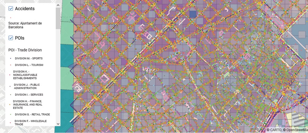
According to the World Health Organization, nearly 1.3 million people die each year due to road traffic crashes, which is a leading cause of death for children and young adults aged 5-29 years. Therefore, knowing the conditions under which accidents happen and the spots where they occur is vital information that can save lives. In Barcelona, there is a rich Open Data catalogue on accidents. Here, CARTO identified different data sources that can influence accidents. All premium datasets were obtained through CARTO’s Data Observatory. “CARTO is a flexible LI platform that is able to run advanced geospatial analytics at scale, derive data-driven insights and provide a set of Web-based tools to build intuitive and easy to use applications for both emergency response teams and the communities,” says Javier Pérez Trufero, Head of Data, CARTO. Data suggested that accidents were heavily influenced by space, time, and other factors such as age, type of vehicle, traffic, type of roads, and human mobility. “Our tools provide interfaces for any user, bringing the power of Location Intelligence to the hands of non-GIS experts in a collaborative manner,” adds Trufero.

The Center for Systems Science and Engineering at Johns Hopkins University developed a dashboard to visualize and track COVID-19 cases in real time | Picture Credit: www.gisanddata.maps.arcgis.com

Natural disasters
Location Intelligence empowers emergency responders to be better prepared and undertake rescue and recovery operations guided by a clear understanding of the situation. The knowledge of location also ensures minimum damage to assets in the event of a calamity. With location-rich insights, tools such as digital maps, GPS trackers and geosensor networks can help public officials and disaster management professionals to reduce functional gaps and enable real-time tracking and movement of dispatched first responders to assist distressed citizens,” says Abhijit Sengupta, Director & Head of Business, India, SAARC Region & Southeast Asia, HERE Technologies.

TROPCYC, a GIS-based solution, assesses cyclonic data to create predictive reports regarding the risk and impact for business assets in a cyclone-prone area. The application uses data collected over the past 129 years to help identify high, medium, low and no-hazard zones based on wind speed and flash floods. “It predicts the cyclones that may hit a location in the next ten years and also their intensities. This information can be used to estimate Maximum Probable Loss (MPL). The best option is to arrive at realistic MPL estimates based on the past claims experience in cyclone damages,” says Dr. Shrikant Gabale, Director, Unity Geospatial LLP.

Hurricanes often lead to severe flooding that leaves homes vacant until they can be fixed. Lanclos tells that the Houston Police, while analyzing an online map, noticed a series of burglaries at such homes after Hurricane Harvey in 2017. The department responded by focusing on the most recent areas to be burglarized, sending several undercover officers to watch for the next attempt. In less than a week, the burglars were caught and the stolen items were recovered from them.

According to Dr. Ravan, the United Nations Platform for Space-based Information for Disaster Management and Emergency Response (UN-SPIDER), a program administered by the United Nations Office for Outer Space Affairs, helps developing countries in building disaster resilience, enhance early warning and prepare for an effective response using Space-based technologies. “The UN-SPIDER has focussed on assisting developing countries to use Space-based information in the full disaster management cycle. While doing so, it has contributed to achieving targets of the Sendai Framework for Disaster Risk Reduction 2015-2030 by the Member States,” he says.

Working with open and premium data, CARTO identified different data sources that can influence accidents in Barcelona | Picture Credit: www.carto.com

Crime
Policing agencies worldwide are imbibing LI in their processes to achieve higher public safety and quicker response. A good example of this can be that of El Paso County 911 District in Texas that supports 38 local public safety agencies through a common dispatch system. In 2019, El Paso suffered a mass shooting incident that resulted in 22 deaths and 26 injuries. With the help of Hexagon’s dispatch system, the 911 district was able to double the number of call takers in 45 minutes and increase the number of teams dedicated to police.

“More than ten years ago, Zurich City Police overhauled their control room and implemented our dispatching system. Next, they wanted to build on that success and further equip responders in the field with real-time information. So, they added our mobile solution via tablets. Another challenge was to improve the ability to locate callers without violating their privacy, and so they added our SMS location capabilities. To support regional coordination during incidents, they implemented our major event management solution as part of an association of 40 diverse emergency services organizations,” shares Sims.

Location has been at the heart of emergency management for years. However, technological developments and the location awareness have changed how governments and other organizations respond to emergencies.

Making data actionable

Data analytics platforms are evolving at a breakneck pace, democratizing access to vast amounts of data and advanced analytics to a large audience of users. This will translate into increased adoption of data-driven processes and actions by emergency responders in different areas. “The ability to collect data and to model more complex threats will allow us to build more resilience against such events and provide us with the capabilities to anticipate and work on preventive measures that couldn’t be taken before,” tells Trufero.

Voicing a similar opinion, Dr. Gabale says, “Data analysis has become much easier. Timely data about cyclonic events can be processed and analyzed using Artificial Intelligence and Machine Learning. Various models can be created using different algorithms for forecasting and predicting future cyclonic events.”

Even though modern technologies make location data more actionable, data itself can make any emergency response system slow. “The growth of data sources is a major issue for so many organizations. It’s an opportunity but also a challenge. Our focus is to ensure that data from traditional calls for services, next-generation communication sources, IoT devices, and other sources can be collected, integrated, managed, visualized, analyzed and made actionable as quickly as possible,” explains Sims.

Agrees Trufero, who adds, “We need to avoid saturating emergency response teams and citizens with too much data, complex data science models or technology that cannot be digested. It is of capital importance not to pass all that complexity to the end-users, but to give them visual, easy-to-use, and collaborative emergency management tools for visualizing and analyzing data-driven insights in a way that reduces their time-to-action.”

The road ahead

If the pandemic has taught us anything, it’s that we can’t simply rely on a good defense anymore. The days of merely reacting to the latest malady or only trusting our experience from a previous response to guide the next one are over. “Emergency response teams should lean into preparedness and resilience efforts, using Location Intelligence as a foundation to understand ‘where’ the next crisis may arise and how to best prevent or mitigate dire consequences for residents and customers. We can’t continue on the path of respond, recover, repeat,” says Lanclos.

“The shift we are seeing and will continue to see is that LI is becoming more of a capability or feature of a solution than a solution on its own. We are focused on bridging the gap between the geospatial and operational worlds. You can’t have the map without the operational system and vice versa. But true collaboration requires all of it — the data, the people, the visualization, the analysis, and the interactivity between all of those. Making data actionable is the whole point. Knowing where to be, with the right resources is all that matters,” concludes Sims.

More Prime Read

… And Gorakhpur follows the suit

Vaishali Nandan President, Society for Planning & Research in Sustainable Management (PRISM) Gorakhpur 273006 Email: [email protected] Gorakhpur strives for E-Governance through GIS that will increase transparency and accountability and reduce

… Mission Impossible?

The laws of environment are to be maintained by the laws for environment! As a part of it, Environmental Impact Assessment (EIA) of any project is of utmost importance. Environmental

…A decade that was

Khadija Sultana Khan GIS Development In its resolution 44/236 of 1989, the United Nations General Assembly announced 1990-2000 as the International Decade for Natural Disaster Reduction (IDNDR). The objective was