Sinergise, a Slovenian geospatial software company founded more than 15 years ago, ventured into space when Sentinel-2 was launched. Its first client was in Ghana. Today, it works with the private sector as well as governments from Slovenia and other countries. The company has a range of partners and clients across application developers in precision farming, oil and gas, and mapping. It also works with data scientists who create various machine learning (ML) workflows and need fine-tuned data for analysis.
Sinergise’s vision is to make Earth Observation (EO) data a part of everyday decision-making and popularize it akin to Google Maps — for route optimization or similar activities, but mainly to figure out what’s going on the planet, and where, and what would be the impact of an individual’s specific action. The ambition extends not just to predictions and visualizations but linking various datasets for even the most quotidian human tasks.
As an example, Grega Milcinski, Co-Founder and CEO, Sinergise, says that before purchasing a fashionable apparel, EO data should help to provide the customer details of the garment factory, supply chains, carbon footprint, pros and cons in terms of environmental impact, and many other things. Information and data for conscious awareness that can play a role in climate change mitigation is the Sinergise motto.
“There is so much value and utility in EO data that everyone wants to use it. There are scarcely few other systematic sources of information available at such a large scale, and there’s no alternative to satellite data in providing systematic, objective truth about our planet,” says Milcinski in an exclusive interview with Geospatial World.
There are two important aspects to the management of land — to have both the ability to precisely register the ownership of land, and the tools in place to ensure the data is up to date. The former part is obviously a prerequisite. To protect people’s and company’s rights, land cadaster tools must support complex spatial topology management, audit trail, and workflows. This part is not rocket science, but it is just a lot of engineering work that needs to be done right to put all puzzles in place. Our ‘Giselle Land Administration’ suite covers the entire process, from registering the contract, spatial data and up to property valuation and taxation.
How can a government know what is happening on each of the millions parcels in the country? This is where satellite imagery comes handy. For example, we established a system for the government of Azerbaijan that collects satellite data over the entire country: a combination of Sentinel and AzerSky data that’s checking for change of land-cover and construction of new buildings. The data is then cross-checked with official records and analyzed by government functionaries to see whether some of the activity is illegal.
We started with tools to support European Common Agriculture Policy (CAP) enforcement. CAP is also a kind of land management, so tools for precise registration are essential. The more important part, also the more complex one, is ensuring sustainable agriculture practices. In EU, there is a large focus on keeping agriculture in harmony with the rest of the ecosystem — crops and grasslands are an important element in biodiversity.
Until recently, policy enforcement was mainly driven by field checks or focused control with remote sensing actions. The Copernicus mission, however, revolutionized this, allowing for the first time to monitor the activity in an ongoing manner — ‘wall-to-wall’.
The fact that one can automatically identify mowing and ploughing events, non-homogeneity, and recognize the change of land cover, is nothing short of miraculous. A combination of data processing, ML, and efficient workflow management is what it takes to govern the policy.
Sinergise developed a set of Area Monitoring tools and services, which make this task manageable — from automatic parcel delineation, to signal processing, to services for creation of markers, business rule engine, as well as so-called “Expert Judgement application.” These tools and services can be integrated with existing systems or applications developed by our partners.
Our partnership began when we were working on the Area Monitoring solution in our own country. It is based on Copernicus Sentinel satellites, which are powerful machines providing high quality data systematically. We have, however, bumped into two challenges.
First one is resolution — in Slovenia, almost a quarter of the agriculture parcels are so small or narrow that there is not even a single Sentinel-2 pixel available fully within, preventing high-quality signal.
The second issue is the cadence in areas with common cloud cover. Sentinel-2 with its 5-daily revisit time is precious, but sometimes not enough. And Sentinel-1 SAR data lacks spectral information, which is very important for vegetation monitoring, and come at even coarser resolution.
We first tried to work around this with the use of other very high-resolution (VHR) data providers, but the existing state of the art and business models are simply not feasible for an ongoing (at least weekly!) monitoring of scattered areas. Planet Labs, however, is at a sweet spot. Its 3–4-meter resolution data, available on a daily basis, is just perfect for the task.
Planet Fusion, which harmonizes the signal to Sentinels, made the process simple as we could use the same ML models for both. While working with Planet on this project, we realized that our Sentinel Hub tools make it super easy to process this large data collection, providing seamless tools to get time-series data for clipped areas. So, we decided to offer this to all other Planet partners and customers as well.
AI4Food is a research project we just started with VITO and University of Valencia, sponsored kindly by ESA. Its focus is on fusing signals from various sensors to improve ML methods related to agriculture and land cover monitoring. We find it extremely important as it will systematically address the technical challenges that are around for the last couple of years. And crucially, the results will be open-source and reusable.
Sustainability is all about obtaining more with less. There is no question at all that most of the people in the developed world have too much of stuff. With more of the population getting to this stage, it is obviously no longer sustainable. And having all these objects in possession does also not really make us happy. It is just a distraction. Therefore, we will all have to get used to being more modest with our needs. It might actually help us become more humane. We should be enjoying life, not things.
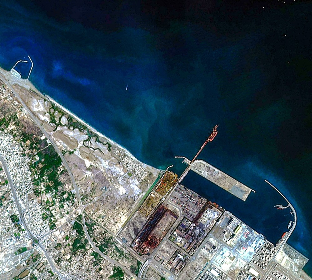
Omani company Etco Space launched its first satellite, the Aman-1 in November 2023. The satellite has captured its first images of Sohar Port and a mountainous range of the Western
This technology will help to check the movement of the public in Italy
© Geospatial Media and Communications. All Rights Reserved.