Lisbon’s City Scale Digital Twins for Flood Resilience
Lisbon's City Government uses Digital Twins to develop a drainage master plan to mitigate the risks from rising sea levels and frequent extreme rainfall events.
Climate Change is accelerating extreme weather events across the globe, especially in coastal and low-lying areas. For the city of Lisbon, rapid urbanization has combined with climate-related issues like rising sea levels and frequent and extreme rainfalls, leading to increased flood risks and soil imperviousness in the region.
The problem
As extreme weather events continued to strain the existing and often inadequate drainage infrastructure in the city, often lives and livelihoods of the citizens were at risk since there were significant damage to property and infrastructure. To improve the city’s flood resilience with data-driven planning, development, and operation, the city government decided to create a Digital Twin for urban flood simulation. Flood Resilience Models using Digital Twins help optimize the performance of the existing drainage infrastructure assets and to take preemptive steps for superior flood resilience planning.
The solution
Digital Twins are defined as a virtual representation of a physical asset, process, or system, created from sets of continuously updated data (real-time spatial data) from a multitude of sensors (including IoT, RFIDs, smartphones, geospatial tools, etc.). The use of real-time data in Digital Twin models provides the authorities with real-time status of the city infrastructure and its assets; while simultaneously providing data to city agencies for flood risk assessment, emergency situations, etc, to make informed decisions at the right time.
The development of a flood resilience model entails the integration of city-scale reality modelling, 3D mapping, and flood modelling, which when combined on a GIS platform can be used for visualization, simulation and analytics.
The Digital Twin solutions helped the city to comprehensively model alternative scenarios to develop a fool-proof and comprehensive drainage master plan for several return periods. The flood resilience models enabled them to better respond to the extreme weather conditions.
The process
For this project, spatial data was collected from drones and ground-level imagery (complemented with laser scans, when required) for use in reality models and 3D mapping software to generate a high-resolution, precise and accurate, city-scale 3D reality mesh. The reality mesh was further tied to underlying GIS data – especially of buildings, parcels and other critical elements of infrastructure assets and also included digital terrain data, which is fundamental for any hydrological simulation. The creation of the reality model thus enabled the engineers to perform development and operations work directly off the model due to the high-resolution of the model.
Flood modeling scenario using different datasets from drones, satellite imagery and laser scans on a GIS platform
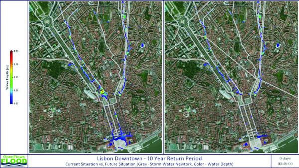
Using the reality model/mesh, a flood resilience model was established by setting up a computational mesh for the area of interest and as a base to source the digital terrain data to provide a visually realistic context for viewing flood simulations in the computational mesh. Additionally, the computational mesh included real-time spatial (collected for reality modelling) and non-spatial data (real-time feeds of meteorological data, current hydrological conditions, rainfall index, etc.,) to develop the flood resilience model. High-resolution computational meshes were applied with more than 500,000 nodes, corresponding to a spatial resolution of four meters. These computational meshes were based on interpolations from up-to-date topography and planimetry data layers. The model was then integrated with the sewer and stormwater networks to dynamically simulate urban stormwater flow and drainage to understand the potential flooding in the region due to storm surges. To create the flood resilience model, Bentley’s OpenFlows WaterOPS service was used.
The flood resilience model, thus created, provided the city authorities with a virtual representation of the various simulations – of the impact of stormwater flows on the infrastructure and assets of cities based on different ranges of velocity, flow and direction of the stormwater.
Flood Simulation in downtown Lisbon, Portugal – Two Different Scenarios
Mitigate flood risk in the Lisbon through intervention in the existing infrastructure
Enhance drainage capacity of existing stormwater systems
Construction of two new tunnels to deviate the excess stormwater from critical areas
Achieve Urban Flood Simulation to comprehensively model alternative scenarios and help Lisbon avoid floods over the next few years
The value proposition
In Lisbon, what-if scenario’s generated by the flood resilience models based on the Digital Twin models is estimated to avoid 20 floods in the next 100 years and save more than EUR 100,000,000 in damaged infrastructure and loss of livelihoods.
The authorities also used the flood resilience model to identify the best trajectory and size of the two tunnels that were to be constructed using the different simulations. The varied simulations enabled the authorities to determine flood risks for existing drainage infrastructure conditions and also evaluate and propose mitigation and resilience strategies for new infrastructure. Further, the city is now able to efficiently perform predictive analysis of the city’s water supply, wastewater, stormwater, and other water systems to forecast flood risks and take necessary proactive actions and preventive measures before any flood wave arrives.