
US: The Southern Nevada Water Authority is conducting a survey of the entire region to figure out how much water those plants might need. Therefore, high-tech surveillance is being done using aerial photography and high-resolution laser mapping to track what is growing in the valley and figure out how much water those plants might need.
The region’s wholesale water supplier is using a combination of aerial photography and high-resolution laser mapping to track what is growing in the valley and figure out how much water those plants might need.
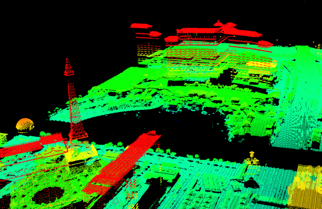
The imagery data is mostly used in the design, construction and maintenance of the valley’s water delivery system. The laser mapping, also known as LiDAR (an acronym derived from “light detection and ranging”), is particularly useful in creating detailed, 3-D elevation maps that help determine where and how pipelines, pumps and reservoirs should be built in a service area that rises from about 1,200 feet above sea level in the east valley to almost 4,000 feet in Summerlin.
But the ever-improving technology is also helping inform the water authority’s conservation outreach by providing a new level of detail about the size, height and type of individual trees and the slope of turf-covered areas.
If a grassy hill is too steep to hold water or support recreation, for example, it might make a good candidate for the authority’s Water Smart Landscapes Program, which pays people to rip out their thirsty grass and replace it with desert plants.
Craig Hale is the authority’s project manager for spatial technologies. He said when the Las Vegas Valley was mapped using LiDAR in the 1990s, the resolution was “coarse,” with each data point representing 30 square meters. The data collected during flights this April and May shows detail down to about 1 square meter.
But the technology isn’t perfect. He said the LiDAR instruments seem to have some trouble getting accurate readings from newly surfaced streets and, ironically, bodies of water. For the conservation program, the LiDAR data is being “married” with aerial photos and infrared images shot each spring to produce a detailed landscape map of North America’s driest major city.

