
US, September 11, 2014: UC San Francisco (UCSF) is working to create an online platform that health workers around the world can use to predict where malaria is likely to be transmitted using data on Google Earth Engine.
 With the malaria prediction platform, local health workers will be able to upload their own data on where and when malaria cases have been occurring and combine it with real-time satellite data on weather and other environmental conditions within Earth Engine to pinpoint where new cases are most likely to occur. That way, they can spray insecticide, distribute bed nets or give anti-malarial drugs just to the people who still need them, instead of blanketing the entire country.
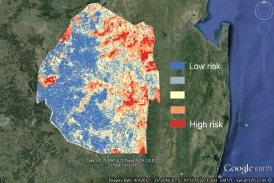
The new tool will be piloted in Swaziland, a country in southern Africa that has limited malaria to a few small pockets across the country through the malaria elimination program it launched in 2008 with help from the Global Health Group. Plans are to make the tool available to health workers in other countries working with the Global Health Group’s Malaria Elimination Initiative. The tool could also be adapted to predict other infectious diseases.
The initiative is concentrated on helping 34 countries in Africa, Asia, Latin America and the Middle East. With effective interventions, adequate financing and political commitment, UCSF experts believe these countries could interrupt malaria transmission and eliminate the disease within 15 to 20 years.
Google Earth Outreach, which helps nonprofits use Google’s mapping technology, is giving UCSF $100,000 to develop the new platform.
Source: UCSF

