
India: RMSI has developed India‘s first countrywide flood risk model, IndiaFloodRisk that provides comprehensive flood risk assessment for the entire country covering 19,000+ pincodes. India FloodRisk combines hydrological and hydraulic modeling techniques with statistical probabilistic flood risk modeling to estimate flood risk for the entire country.
This is the only model that captures both riverine as well as flash floods. It is based on 50 years of flow data and 109 years of rainfall data that reduces the uncertainty due to derived flows and ensures fairly accurate representation of man-made floods.
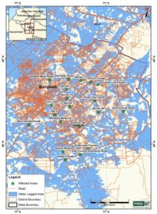
For instance, flooding from the last month’s rain at the Millennium City, Gurgaon was reeling under massive water logging and long winding traffic jams, giving nightmares to road travellers and its occupants. Unable to provide adequate support, various authorities just went on to blame one another. The same situation occurred in Bangalore during Chennai floods in 2015.
Events like these are not new to India and are the true examples of how demographic changes and mindless urbanization lead to urban flooding. And the callous attitude of authorities in such crisis shows the lack of seriousness in authorities.
While words like ‘Global’ and ‘Smart’ cities sound good to the ear, but it would be nice for the municipal corporations and state authorities to first look at the ground realities of a city before planning infrastructures for smart cities. The authorities need to conduct a detailed analysis of the water carrying capacity of storm water drains, natural drains and existing water bodies.
Blindfolded urbanization has led to drying up of the various lakes and reservoirs in the city with the situation further worsening due to unprecedented construction on these dried up water bodies. In a similar scenario, Bangalore received over 135 mm of from 25th to 28th July, and a total of 195 mm in July 2016 – the highest recorded rainfall in the month of July during the last seven years (the last highest recorded rainfall was 283 mm in 2008).
It is important to understand the change in water flow due to the changing topography. All this can be achieved through hydrological and hydraulic modeling of the region and the storm water network. Gurgaon, the most upcoming global hub of India has witnessed large scale construction activities in the last few decades.
Despite that, every year during heavy downpour, the city roads clogged up due to water obstructing all natural drain channels in the city. Hence the question arises what can we do to fix it? The authorities need to conduct a detailed analysis of the water carrying capacity of storm water drains, natural drains and existing water bodies. It is equally important to understand the change in water flow due to the changing topography.
All this can be achieved through hydrological and hydraulic modeling of the region and the storm water network. RMSI’s IndiaFloodRisk is the first countrywide flood risk model for India, providing comprehensive flood risk assessment for the entire country covering 19,000+ pincodes.
RMSI has been providing complimentary initial flood advisory and flood maps of live flood events to the Indian insurance industry to help them better understand the flood events in India and their impact. India FloodRisk model has been used to come out with a Top 10 list of the most flood prone cities in the country. Both Bangalore and Gurgaon fall in the Top 5 most flood prone cities as per the current conditions on the ground.
It is high time that the authorities take note of these alarms and ensure proper planning of these cities, starting with the steps outlined above, lest, we should be ready to brace huge losses to human life and property and the economy at large.

