

GKI Training Program Partners





What is Geospatial Knowledge Infrastructure (GKI)?
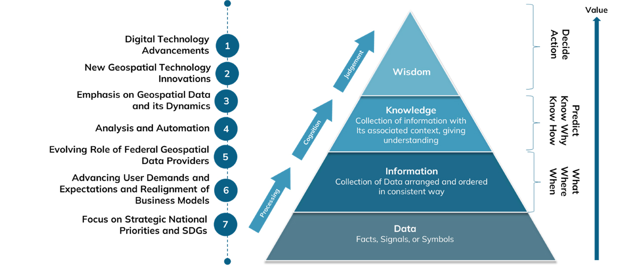
The global geospatial landscape is undergoing a foundational shift — from legacy Spatial Data Infrastructures (SDIs) to a more advanced, integrated paradigm known as Geospatial Knowledge Infrastructure (GKI). This transformation is not merely technical; it marks a strategic evolution in how nations and institutions mobilize geospatial assets to derive actionable intelligence in an increasingly data-driven world.
GKI represents a next-generation framework that transcends the conventional mandates of data collection, storage, and dissemination. Anchored in the principles of the Fourth Industrial Revolution (4IR), it integrates geospatial technologies with AI, cloud computing, and IoT to enable real-time, predictive, and context-aware insights. In doing so, it moves the value chain decisively from data to decision — placing geospatial intelligence at the core of national digital infrastructure.
This evolution is propelled by the imperative to embed geospatial capabilities across public governance, industrial ecosystems, and the global digital economy. Whether enabling smart cities, climate resilience, or digital twin technologies, GKI offers a cohesive architecture for aligning policy, infrastructure, and innovation. It equips governments and enterprises alike to respond with agility to complex challenges — making decision-making not only smarter and faster but also more sustainable and systemically informed.
In an era where digital competitiveness is increasingly geospatial in nature, GKI is not just a technological upgrade; it is a strategic enabler of national resilience, economic opportunity, and global leadership.
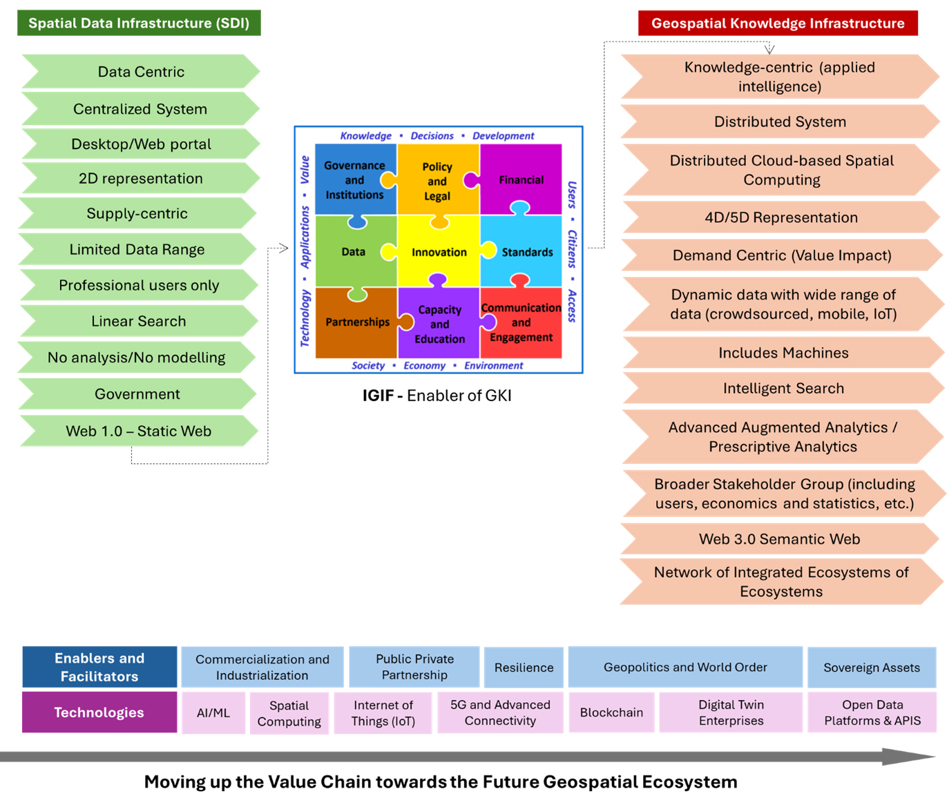 Source: Geospatial World Consulting
From SDI to GKI — the third generation: The transition to Geospatial Knowledge Infrastructure (GKI) signals the emergence of a third generation in the evolution of geospatial systems. The first generation was data-centric, focused on building the foundational capacity to collect, manage, and store spatial data. This was followed by the second generation, characterized by process-driven frameworks that integrated geospatial data into specific workflows, enhancing decision-making within siloed applications.
Today, the shift toward a knowledge-powered paradigm reflects a broader imperative: to generate actionable insights that inform real-time, system-level decisions. GKI embodies this transformation by leveraging advanced analytics, AI, and interoperability to convert data into strategic knowledge. It positions geospatial systems not merely as repositories or tools, but as critical infrastructure for national resilience, digital governance, and economic competitiveness.
Senior Executive Training Program on GKI
The rapid evolution of geospatial technologies is transforming how governments and institutions collect, manage, integrate, and use geospatial information for planning, service delivery, and decision-making. However, realizing the full value of these capabilities requires moving beyond fragmented data and systems towards an integrated ecosystem that connects data, technology, institutions, policies, people, and decision-making. Geospatial Knowledge Infrastructure (GKI) provides a strategic framework for enabling this transition and strengthening the way geospatial knowledge is developed, governed, shared, and applied.
The Senior Executive Training Programme on Geospatial Knowledge Infrastructure (GKI) is designed to equip senior government officials, National Mapping Agencies, geospatial authorities, policymakers, and key user sectors with the strategic understanding required to develop and operationalize GKI. Through expert-led sessions, practical experiences, emerging technologies, real-world case studies, and strategic discussions, the programme will explore GKI principles, governance, institutional readiness, interoperability, technology, innovation, capacity building, and sectoral applications, enabling participants to develop a clear perspective on building integrated, intelligent, and future-ready geospatial ecosystems.
Training Outline
The first three days will comprise an executive capability-building programme focused on the concepts, architecture, and operationalization of Geospatial Knowledge Infrastructure (GKI). Designed for senior officials from National Mapping Agencies, government institutions, and geospatial organizations, the programme will cover the evolution from Spatial Data Infrastructure (SDI) to GKI, communicating the strategic value of geospatial knowledge, IGIF as an enabling implementation framework, and the governance, policy, and institutional foundations required for future-ready geospatial ecosystems. Participants will further explore intelligent platform architectures, AI, cloud computing, IoT, Positioning, Navigation and Timing (PNT), interoperability and standards, Earth Observation, and the integration of GKI across infrastructure, natural resource management, environmental monitoring, and disaster management through expert-led sessions, global case studies, and peer learning.
The next three days will immerse participants in the GeoSmart India Conference and GKI Summit, providing a platform for engagement with global geospatial leaders, policymakers, technology providers, academia, and industry. Participants will attend thought-leadership plenary sessions, interact with experts shaping the future of geospatial ecosystems, and experience dedicated technology demonstrations on geospatial analytics, platform infrastructure, GNSS/PNT, and high-resolution aerial and 3D imaging. The programme will conclude with an assessment workshop to consolidate key learnings, and a certification ceremony, fostering long-term collaboration and a regional community of practice for advancing Geospatial Knowledge Infrastructure.
Learning Objectives
OBJECTIVE
Understand how GKI enables smarter governance, digital transformation, and national development.
OBJECTIVE
Gain insights into building future-ready geospatial ecosystems through effective strategy, governance, and collaboration.
OBJECTIVE
Learn how to transform geospatial data into actionable intelligence for policy and decision-making.
OBJECTIVE
Explore the role of AI, cloud, digital twins, and emerging technologies in shaping next-generation spatial systems.
OBJECTIVE
Discover global best practices and practical approaches to implement GKI at national scale.
OBJECTIVE
Develop strategies to strengthen geospatial readiness, innovation, and sustainable growth through GKI.
Training Registration
| Training Program | Fee |
| Registration Fee for Training | INR 40,000 |
| Registration Fee for Training (with accommodation for 7 nights) | INR 100,000 |
*Inclusive taxes
Registration & Cancellation Policy
- Cancellation for a paid registration received on or before 15 October 2026 shall be refundable with a processing fee of INR 1,500.
- Registration cancellation requests received from 15 October-15 November 2026 will only be provided 50% refund
- There will be no registration fee refund after 15 November 2026
- Transfer your pass to a colleague once in case of unforeseen circumstances or medical emergencies
For more details, contact

VP-Consulting
Geospatial World
[email protected]

Senior Research Analyst
Geospatial World
[email protected]