Senior Executive Training Program on Geospatial Knowledge Infrastructure (GKI)

Theme: Advancing India’s Geospatial Future: Integrating National Priorities with State Capabilities

29 November - 4 December 2025 Delhi, India
Organized by

Background

The global geospatial landscape is undergoing a foundational shift—from legacy Spatial Data Infrastructures (SDIs) to a more advanced, integrated paradigm known as Geospatial Knowledge Infrastructure (GKI). This transformation is not merely technical; it marks a strategic evolution in how nations and institutions mobilize geospatial assets to derive actionable intelligence in an increasingly data-driven world.

GKI represents a next-generation framework that transcends the conventional mandates of data collection, storage, and dissemination. Anchored in the principles of the Fourth Industrial Revolution (4IR), it integrates geospatial technologies with AI, cloud computing, and IoT to enable real-time, predictive, and context-aware insights. In doing so, it moves the value chain decisively from data to decision—placing geospatial intelligence at the core of national digital infrastructure.

This evolution is propelled by the imperative to embed geospatial capabilities across public governance, industrial ecosystems, and the global digital economy. Whether enabling smart cities, climate resilience, or digital twin technologies, GKI offers a cohesive architecture for aligning policy, infrastructure, and innovation. It equips governments and enterprises alike to respond with agility to complex challenges—making decision-making not only smarter and faster but also more sustainable and systemically informed.

In an era where digital competitiveness is increasingly geospatial in nature, GKI is not just a technological upgrade; it is a strategic enabler of national resilience, economic opportunity, and global leadership.

Figure 1: GKI: The Blueprint for the Future Geospatial Ecosystem

The transition to Geospatial Knowledge Infrastructure (GKI) signals the emergence of a third generation in the evolution of geospatial systems. The first generation was data-centric, focused on building the foundational capacity to collect, manage, and store spatial data. This was followed by the second generation, characterized by process-driven frameworks that integrated geospatial data into specific workflows, enhancing decision-making within siloed applications.

Today, the shift toward a knowledge-powered paradigm reflects a broader imperative: to generate actionable insights that inform real-time, system-level decisions. GKI embodies this transformation by leveraging advanced analytics, AI, and interoperability to convert data into strategic knowledge. It positions geospatial systems not merely as repositories or tools, but as critical infrastructure for national resilience, digital governance, and economic competitiveness.

Figure 2: GKI: Establishing the Geospatial Knowledge Infrastructure—Towards the Future Generation

A knowledge-powered geospatial paradigm enables the transition from merely observing patterns to actively shaping outcomes—through prescriptive analytics, adaptive systems, and autonomous decision-making. Yet, this shift requires more than technological innovation; it calls for the holistic integration of people, processes, policies, and platforms. Only by building such an ecosystem can geospatial knowledge be transformed into operational wisdom capable of addressing complex, interlinked global challenges.

As the geospatial ecosystem advances and GKI reshapes the dynamics between data, algorithms, and human insight, national sovereignty and resilience are becoming critical pillars of this evolution. By linking geospatial intelligence with sovereign capabilities across the full technology stack—from satellites and GNSS to cloud and real-time analytics—GKI now serves not just as a value-creation roadmap but as a tactical readiness framework that empowers nations to operationalize geospatial and space infrastructure for autonomy, security, and future-ready growth.

+ Read more

Geospatial Knowledge Infrastructure for India

India is at a defining moment in its geospatial journey. With the National Geospatial Policy 2022, Indian Space Policy 2023, and guidelines for geospatial data, the country has laid down a progressive framework for liberalized data access and private sector participation. Foundational infrastructure is expanding rapidly through the Survey of India, ISRO, NRSC, and platforms such as Bhuvan and PM Gati Shakti, while flagship programs like SVAMITVA, NAKSHA, and Operation Dronagiri are driving innovation and ground-level adoption. Together, these initiatives highlight India’s strategic intent to build a globally competitive geospatial economy with private sector engagement across drones, mapping, and earth observation.

At the same time, challenges remain. Data availability and quality are uneven across states and sectors, slowing down the creation of a seamless national ecosystem. The integration of real-time data systems and advanced analytics into mainstream public services is still limited. Moreover, geospatial literacy and institutional capacity vary widely across ministries, states, and municipalities, creating gaps between national ambitions and local implementation.

This is where Geospatial Knowledge Infrastructure (GKI) provides a unifying pathway. GKI enables India to transition from siloed assets to an integrated, sovereign, and intelligence-driven ecosystem that supports real-time decision-making, sectoral innovation, and resilient governance. By aligning modernization efforts with broader national priorities—digital transformation, Atmanirbhar Bharat, sustainable development, and inclusive growth—GKI can ensure that investments translate into long-term societal and economic impact. Crucially, it helps bridge Central vision with State-level execution, creating a harmonized national geospatial fabric.

The upcoming Training Program on Geospatial Knowledge Infrastructure in Delhi comes at a pivotal moment for India. It will serve as a platform to equip ministries, state departments, and national agencies like the Survey of India with the frameworks to operationalize GKI in line with national priorities. By fostering collaboration across government, industry, and academia, the program will strengthen data-driven governance, institutional capacity, and interoperability at both central and state levels. In doing so, the training will accelerate India’s position as a global leader in applying geospatial knowledge for sustainable growth and digital transformation.

Figure 3: India’s Ranking in the GKI Readiness Index 2025 Source: Geospatial World Consulting

Training Outline

The Senior Executive Training Program on Geospatial Knowledge Infrastructure, organized by Geospatial World along with its partners, Survey of India [SoI], Esri, Overture Maps Foundation, Foundation of Ecological Security [FES], Woolpert, SDG Data Alliance of PVBLIC Foundation, and United Nations Statistics Foundation, is scheduled to be held from the 29th November – 4th December 2025 in Delhi, India. The program will be conducted in two phases –

Capability Building & Enablement Program for GKI

The first three days (29 November – 1 December 2025) will begin with focused training programs on concept, framework, and processes of Geospatial Knowledge Infrastructure organized with an intent to enhance the participants’ understanding of the Geospatial Knowledge Infrastructure (GKI) framework and its applications in India in alignment with the country’s national and state’ priorities. Designed for senior officials from national mapping agencies, government bodies, industry, and academia, the training will equip participants with practical tools to design, implement, and scale resilient, interoperable GKI ecosystems. Sessions will explore the GKI’s ecosystem approach, socio-economic impact, India’s geospatial knowledge infrastructure architecture need and requirements, interoperability and standards, foundational datasets and platforms, partnership models, and technology enablers such as AI, digital twins, drones, and IoT. Special focus will be given to GKI applications for architecture, engineering and construction, and ecological and resource management, and sustainable development, with interactive discussions, hands-on exercises, and collaborative forums enhancing learning outcomes.

Industry Engagement and Collaborative Ecosystem Building

The next three days (2–4 December 2025) will focus on industry engagement at GeoSmart India. This platform will convene government leaders, industry innovators, startups, academia, and multilateral organisations to showcase advanced solutions and foster partnerships for future-ready geospatial ecosystems. GeoSmart India provides participants with the opportunity to collaborate with peers and experts, engage in hands-on exercises, and contribute to sector-specific discussions that directly feed into India’s Space and Geospatial ecosystem. With over 5,000–10,000 attendees expected at GeoSmart India, participants will gain exposure to global best practices, collaborative opportunities, and emerging innovations. The training program will conclude on 4th December 2025, where certificates will be awarded to participants, recognising their active involvement, reinforcing key learning outcomes, and celebrating their role in advancing national geospatial knowledge capacity.

Learning Outcomes

By the end of the training, participants will be equipped with the knowledge, skills, and strategies to advance geospatial innovation and integration through the following outcomes:

  • Strategic Foundational Awareness – Understand GKI and its alignment with National Geospatial Policy 2022, Digital India initiatives, and Atmanirbhar Bharat objectives.
  • Standards & Best Practices Implementation – Apply global and Indian standards (OGC, national guidelines) to India’s governance framework and development.
  • Institutional and Multi-stakeholder Collaboration Enhancement – Strengthen collaboration across central, state, and public–private–academic partners.
  • Governance and Interoperability Advancement – Improve data governance and interoperability for inclusive, user-centric geospatial systems.
  • Technology Enablement – Leverage AI, cloud, drones, digital twins, and big data analytics to scale GKI adoption in India.
  • Sectoral Opportunities – Drive geospatial innovation in agriculture, land, disaster, water, transport, and infrastructure programs like PM Gati Shakti and Smart Cities.

Training Methodology

The training programme will consist of a variety of presentations, case study discussions, hands-on exercises, panel discussions and technology demonstrations. Participants will be able to interact with experts in the field, share experiences, and collaborate on practical solutions for increasing geospatial capacity in their respective organizations.

Training Registration

Training Program Fee
Registration Fee for Training INR 40,000
Registration for Training (with accommodation for 6 nights) INR 100,000

*Inclusive taxes

Registration Policy

  • Cancellation for paid registration received on or before 15 October 2025 shall be refundable with a processing fee of INR 1500
  • Registration cancellation requests received from 15 October-15 November 2025 will only be provided 50% refund
  • There will be no registration fee refund after 15 November 2025
  • Transfer your pass to a colleague once in case of unforeseen circumstances or medical emergencies

Agenda

0900 - 1000 Registration & Tea/Coffee
1000 - 1015 Welcome & Introduction
Sanjay Kumar

Sanjay Kumar

Chief Executive Officer
Geospatial World

1015 - 1130 
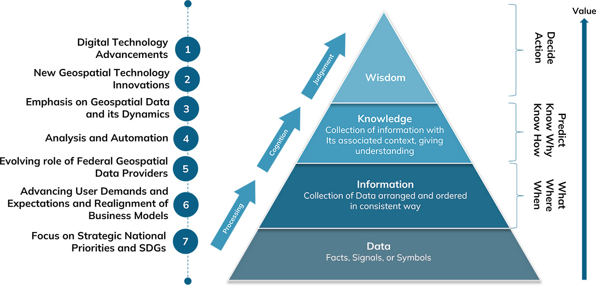
Lesson 1: Geospatial Knowledge Infrastructure - The Future Geospatial Ecosystem

Session Highlight

  • Introduction to Geospatial Knowledge Infrastructure: Core principles and concepts
  • Significance of GKI for national development, digital transformation, and socio-economic growth
  • Understanding the role of national geospatial agencies and institutional ecosystems in the Digital Age
  • Navigating challenges and unlocking opportunities for implementing GKI
  • Strategic pathways and frameworks for strengthening GKI to support national and regional development
Ananyaa Narain

Ananyaa Narain

Vice President - Consulting
Geospatial World

1130 - 1200 Coffee Break
1200 - 1300 Lesson 2: Communicating the Value Proposition of Geospatial Knowledge Infrastructure

Session Highlight

  • Articulating the strategic importance of GKI for evidence-based decision-making with relevant Indian examples and global best practices
  • Highlighting the socio-economic impact of GKI in driving growth and prosperity
  • Methodology to communicate the Return on Investment of Geospatial Knowledge Infrastructure
Ananyaa Narain

Ananyaa Narain

Vice President - Consulting
Geospatial World

1300 - 1400 Lunch Break
1400 - 1500 
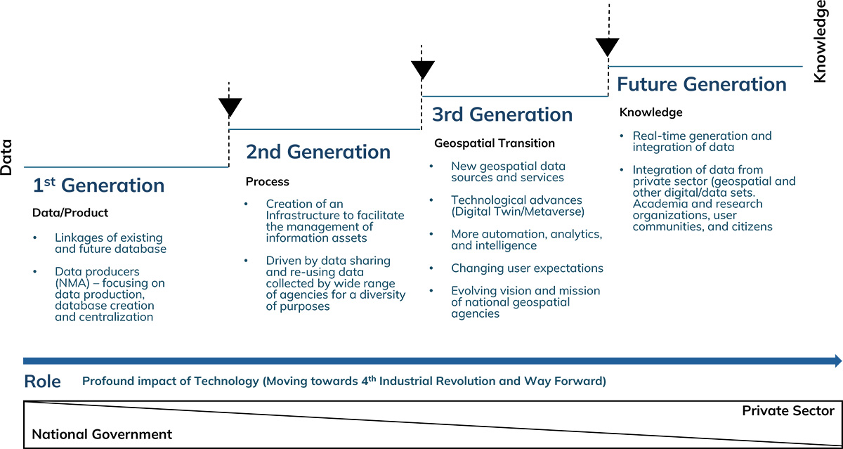
Lesson 3: Building GKI and Prioritizing State-Level Development

Session Highlight

  • Introduction to Geospatial Knowledge Infrastructure and state-centric GKI
  • National Mapping and Geospatial agencies as strategic enablers
  • Strengthening state capabilities in geospatial infrastructure
  • Collaborative Models and Partnerships at the State Level
  • Discussion on pillars of state-level geospatial transformation
  • Alignment with National Geospatial Policy and Need for State-level policy
Oaishik Bhattacharya

Oaishik Bhattacharya

Associate Director - GKI
Geospatial World

1500 - 1530 Coffee Break
1530 - 1730 Lesson 4: Building the Future of GKI in India: Infrastructure, Innovation, and Integration

Session Highlight

  • Designing strategic spatial infrastructure for national and state-level geospatial ecosystems
  • Advanced spatial data management for cross-sector integration
  • Capacity building and skill development for sustainable GKI growth across Indian states
Zaffar Sadiq Mohamed-Ghouse

Prof (Dr) Zaffar Sadiq Mohamed-Ghouse

Vice President and Director-Advisory & Innovation
Woolpert

1000 - 1100 Lesson 5: Information Technology as Critical Enabler of GKI Ecosystem: Role of AI, Big Data, Cloud Computing and IoT

Session Highlight

  • Establishing state-controlled and nationally aligned digital infrastructure as the foundation for geospatial systems
  • Moving from siloed GIS systems to state-governed, cloud-native spatial platforms to enable GKI
  • AI/ML Applications needed for building Established State Data Infrastructure
  • Big Data & IoT-Enabled Real-Time Geospatial Services
Jitender Mehta

Jitender Mehta

Director of Cloud Engineering
Oracle

1100 - 1130 Coffee Break
1130 - 1300 Lesson 6: Integrated Platform Architecture for Governance and Service Delivery

Session Highlight

  • From Data-Centric to Knowledge-Centric: What Changes in a GKI Platform?
  • Designing a Distributed, Cloud-Based Geospatial Platform
  • Integrating Dynamic Data Streams and Multi-Source Inputs for decision-making - a core of the GKI
  • Embedding Intelligent Search, Analytics, and Decision Support
  • Enable Sectoral Service/Applications Delivery through Building an Ecosystem-Centric Platform Governance Model for sustained GKI
Vijay Kumar

Vijay Kumar

Senior Vice President and Chief Technical Officer
Esri India

1300 - 1400 Lunch Break
1400 - 1530 Lesson 7: Fundamentals of Positioning, Navigation and Timing and Relevance in the GKI Ecosystem

Session Highlight

  • Understanding the fundamentals of PNT systems
  • Indian PNT ecosystem and strategic infrastructure
  • Sectoral applications and economic relevance of PNT
  • Challenges of dependence and data sovereignty
  • Future trends and emerging technology integration
B.Nagarajan

Maj Gen (Dr) B.Nagarajan

Professor
Department of Civil Engineering, IIT Kanpur

1530 - 1600 Coffee Break
1600 - 1700 Lesson 8: Interoperability and Integration: Advancing Geospatial Data Infrastructure through Standards and Collaboration

Session Highlight

  • The role of open standards in ensuring interoperability across National platforms
  • Importance of standards and strategies for aligning Centre, state and local GKI ecosystems
  • Need to eliminate data duplication, fragmentation and strengthening metadata protocols
  • Developing federated NGDI architectures to enable seamless central-state data exchange
Harsha Madiraju

Harsha Madiraju

Associate Director
Open Geospatial Consortium (OGC)

0930 - 1100 Lesson 9: Harnessing Earth Observation Data for National Mapping

Session Highlight

  • Typology and data ecosystems of Earth Observation
  • Moving from thematic information towards sectoral intelligence integration
  • Operational application and creating strategic impact
  • Emerging technology integration and the future of Earth Observation
Hrishikesh Samant

Dr Hrishikesh Samant

Professor of Geology
St. Xavier's College, Mumbai

1100 - 1130 Coffee Break
1130 - 1300 Lesson 10: GKI Workflow Integration Across AEC/ Infrastructure Sector

Session Highlight

  • Leveraging GKI for Smarter Infrastructure Design and Development in the Indian context
  • Digital Twins in AEC: GKI's Role in Real-Time Data and Simulation
  • Integration of GKI with BIM for Streamlined Project Management
  • Enhancing Sustainability in AEC Projects through Geospatial Analysis
  • Case Studies: GKI Implementation in Large-Scale Construction and Urban Projects
John P. Wilson

Prof John P. Wilson

USC Professor and Founding Director of the Spatial Sciences Institute
University of Southern California, USA

1300 - 1400 Lunch Break
1400 - 1530 Lesson 11: GKI Workflow Integration for Natural Resource Management and Ecological Restoration

Session Highlight

  • Leveraging GKI for sustainable natural resource management at the national level
  • Integrating geospatial intelligence into environmental monitoring systems across India
  • Using GKI to support community-driven decision-making processes
  • Building early warning systems through geospatial-enabled insights
  • India Observatory Case Study - Applicability to India
Chiranjit Guha

Chiranjit Guha

General Manager
Foundation for Ecological Security (FES)

1530 - 1600 Coffee Break
1600 - 1730 Lesson 12: GKI Workflow Integration for Disaster Management

Session Highlight

  • Building an integrated geospatial data platform integrating satellite imagery, ground observations, and real-time sensor feeds for disaster intelligence
  • Enabling continuous hazard monitoring and early-warning through PNT-enabled IoT sensor networks and real-time spatial data streams
  • Structuring end-to-end disaster management workflows within a unified GKI framework for coordinated, data-driven response
  • Applying advanced geospatial technologies including SAR, LiDAR, UAVs, and AI-driven analytics to enhance hazard prediction, impact assessment, and infrastructure resilience
  • Embedding geospatial intelligence into decision workflows for faster response and resilient planning
Shirish Ravan

Shirish Ravan

Director
EarthSight Foundation

1800 - 1900 Networking Reception with the CXO Summit Delegates
1900 - 2030 Honouring the Living Legends & GeoSmart India Leadership Awards 2025
2030 - 2200 Dinner Reception
0930 - 1730 GeoSmart India Conference Program

Session Highlight

  • Participation in thought-leadership plenary sessions on:
    • State Geospatial Infrastructure and Industry Development Strategy
    • Sensors to Services: Advancing Turnkey Solutions through Collaborative Business Models
  • Explore strategies connecting technology with governance & gain insights on collaborative models
  • Networking with policymakers, innovators, and industry leaders driving India's geospatial agenda
1000 - 1300 Technology Demonstrations as part of Senior Executive Training

Session Highlight

  • 45-Minute-long immersive technology showcase:
    • Geospatial Analytics & Platform Infrastructure
    • Positioning, GNSS and Precision Infrastructure
    • High Resolution Aerial and 3D Imaging
1300 - 1400 Lunch Break
1430 - 1700 ESRI Technology Track

Session Highlight

  • ArcGIS Reality & Digital Twins: Showcasing advanced 3D reality capture and digital simulation capabilities
  • Geospatial AI for Optical & SAR Imagery: Demonstrating AI-driven analysis and feature extraction across diverse imagery
  • NISAR Data Processing in ArcGIS: Highlighting workflows to transform NISAR's global SAR data into meaningful insights
0930 - 1100 Technical Sessions/Seminars

Session Highlight

  • Deep-Dive Sessions that bridge technical insight with strategic application:
    • Expose participants to emerging technologies like GeoAI, HD Mapping and surveying, LIDAR, Scanning and spatial computing shaping India's geospatial transformation
1100 - 1230 Assessment Workshop

Session Highlight

  • Key Takeaways and Outcomes
1230 - 1300 Closing Ceremony

Session Highlight

  • Presentation of Certificates and Group Photograph