
 The Cold War ended decades ago in 1991 with the fall of Berlin Wall. But the spy satellites of those times are now serving some noble cause – helping scientists to measure and monitor the Himalayan glaciers and tracking environmental change in the region.
And the initial findings of the research project have bad news for us. Glaciers in the Himalayan region are estimated to have seen an annual average mass loss of at least 7 inches over the entire surface of each glacier. The findings were unveiled at 2016 fall meeting of the American Geophysical Union taking place in San Francisco from December 12 to 16.
The Hexagon spy sat program
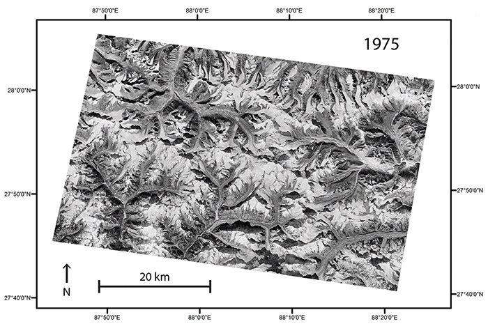
During the 1970s and 1986 US is known to have launched as many as 20 huge reconnaissance satellites into space under a program code-named Hexagon, which secretly clicked photos areas of their interest. This included the Himalayas, an area difficult to map and for which historical data is scarce.
https://skfb.ly/WzZP
Declassification of the data in 2011 allowed scientists to manually build 3D elevation models by matching landmarks between images and calculating the satellite angle. Now, by comparing this old data with more recent satellite images from NASA, a team of researchers have created 3D images of glaciers across the Himalayas, providing the first consistent look at 40 years of glacier change across the region.
What were the findings?
The height of the glacier ice can be seen in the 1974 photos. The researchers took these elevation models and calculated the difference between them and the current elevation models using the ASTER imaging instrument aboard NASA’s EOS flagship Terra satellite. It is estimated that each glacier in the region have suffered an annual average mass loss of at least 7 inches over.
For instance, the first results covering 21 glaciers in the Bhutan region showed that the glaciers have been losing more ice than they have been gaining.
The Himalayan glaciers’ seasonal meltwater is crucial to the 1.7 billion people living in the Indian sub-continent, which is about 20% of the world’s population. “Life depends on water, so changing the amount or timing of how that water reaches a community or an ecosystem is going to have an impact,” lead researcher Josh Maurer, a graduate student at Columbia University’s Lamont-Doherty Earth Observatory in New York City, said in a statement.
Global glacier changes
Images from Hexagon are now being used by various research groups to track how other parts of the Earth have changed over time.
Maurer and his team have developed an automated process that creates consistent 3D models of glaciers across the world as they appeared over time.
“It can take years for a glacier to fully respond to a change in climate, so looking back several decades gives us a better signal,” Maurer said. While we have volume changes over the last decade or so from more modern remote-sensing platforms, glacier response times can be longer than that. The declassified spy-satellite data allows for [finding] actual ice-volume changes over those longer time scales.
The new 3D-mapping tool will help scientists more consistently quantify glacier change and thus give them more realistic estimates on seal level rise, global warming and climate change.
Satellites data, particularly the Landsat 8, are providing detailed information on glacier changes but knowledge of historical change — particularly in the Himalayan region — has been limited.


