
Universidade Federal de Alagoas –UFAL/LAPIS
Maceió -Brazil
Tania Maria Sausen
Geospatial Media & Communication
Porto Alegre -Brazil
1. Introduction:
Disasters caused by extreme weather and climate have brought escalating losses and damage to the environment and life on the planet, such that the economic and financial losses surpass the government budgets, and call into question all sustainable development strategies. So that, the Adaptation has become the new discipline in the arduous pursuit of achieving possibilities to support some degree of sustainability to global communities and societies. Adaptation has the convergence between science and technology for the generation of resilience. The planning and development in general rely on the availability of space systems and, land and ocean integrated technology platforms shared between scientific research and the full support prevention, response and disaster reduction.
The most needed solutions to the generation of environmental data information resources, especially on the harzads and effects of extreme weather, are claimed by the international community, both scientifically and economically and environmentally, for the management and planning of coping to natural disasters, seeking thus a more clear and efficient translation of the disasters and their impacts, and the degree of risk and vulnerability in situ to these events.
Meteorological services, the management of environment and disaster warning systems are traditionally supported by the monitoring of weather and climate and remote sensing of land resources based on space platforms via satellite.
Its main concern monitoring and reducing the impacts of natural disasters, it is possible to make use of second and third generation platforms EUMESAT/EUMECast,, for the development of studies and research on services, applications and products to the environment as well as for climate monitoring, operational and control observations. Thus, with these resources can be planned a strategy of management and disaster reduction as well as to the related impacts.
The regional meteorological services and universities require real-time data and tools to make immediate forecast, and assess the impact on the population caused by severe rain events or continuous. The immediate weather forecast or nowcasting consists in anticipating the occurrence of phenomena of time in minutes to a few hours (Barbosa, 2013). The data that are intended to nowcasting are basically satellites, radar and local weather measurements. These data are in general, very large, which prevents the receipt by internet line, especially in remote areas. In addition, the acquisition of satellite stations dedicated data reception is very costly. For example, the GOES-R will be the primary satellite for Brazil costs hundreds of thousands of dollars and require teams to the operation. The EUMETCast system is a low cost system, easy operation and allows you to receive the main data for this service. Today there are systems of local measures in the regional services with potential for nowcasting techniques based development.
On the other hand, the only reception of weather data without their integration and cross with Land use and land cover data, which may be provided by Earth observation satellites, Meteosat Second Generation or at (MSG), is incomplete and can not answer the needs for management and disaster reduction. This large amount of data to be viewed, analyzed and interpreted jointly and made available to the end user, which often requires a huge effort, not always present in a specific activity dedicated. The TerraMA2, a computer platform development applications Monitoring, Analysis and Alert to geo-environmental extremes is the tool that allows the interface between the user and the data. It is applied to events that cause natural disasters, to water quality / air / atmosphere, to waste ponds and epidemics, among others (Figure 1).
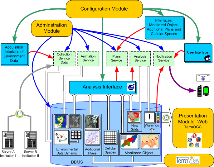 Figure 1- TerraMA2 platform architecture.
Considering the above it was designed a strategic plan based on strengthening of innovative scientific and technological capabilities to support disaster management in the Northeast of Brazil, extending to other regions of the country, supported by the system features (EUMETCast ) monitoring through satellite Meteosat second and third generation. This paper proposes a small and brief contribution to this plan, which must be covered by international strategic partnerships and extensive experience in science and technology applications for Adaptation to Climate Change, to meet the demands of collaborative network between the courses of Post- Graduate Meteorology UFAL, UFCG, UFPB and UFCG.
The purpose of this article is to generate technical elements to support the approved project “Analysis and Forecast of Hydrometeorological Phenomena Intense eastern Brazilian Northeast” by the Joint Call CAPES / CEMADEN / MTCI – Pro-Alerts Notice in 24/2014. The main objective of this project is to support the training of human resources for the development of products derived from environmental satellite data and weather radar, and international cooperation with emphasis on collaboratory between: the PPGMet/UFAL, the PPGMet/UFCG, the PPGI/UFPB and the EUMETSAT / EUMETCast.
2. The system EUMETCast
The EUMETCast system is designed to provide near real-time, dedicated service for the dissemination, exploitation and application of a wide range of data and products from meteorological and environmental satellites to Globe countries and operates through dedicated broadcasting systems using satellites of Geostationary Communication operating within the standard relay DVB-S signals (Digital Video Broadcasting-Satellite). Satellite data, local measures, derivative products and services without format restrictions, are transmitted to users anywhere in the world through commercial telecommunications satellites using the following architecture (Figure 2).
 Figure 2: EUMETCast station.
To improve support and the integration of the EUMETCast system data, we adopted the TerraMA2 platform INPE (National Institute for Space Research) based on Geographic Information System (GIS) applied to the Environment. It is a user-friendly platform available for integration with EUMETCast-Américas products. Already counting on the support of LAPIS (Laboratory for Analysis and Satellite Image Processing), the platform is used through the very EUMETCast system for viewing and processing of incoming products. The data format, such as the coverage map of the daily vegetation of Brazil, generated from Meteosat-10 data (Figure 3), and distribution to the northeast of the daily NDVI estimated by the Meteosat Second Generation (MSG), generated by LAPISmet is adapted to geotiff to create a user friendly interface (Figure 4). This information about land use and land covers, combined with meteorological data is important for assessing the impacts of extreme events and the consequent generation of disasters.
 Figure 3. Map coverage of daily vegetation of Brazil based on Meteosat-10 data. (Source: https://www.lapismet.com).
 Figure 4. Distribution to Northeast daily NDVI estimated by the Meteosat Second Generation (MSG). Areas classification with different classes of land use, using TerraMA2 / INPE.
Geostationary Meteorological Satellites (center on the equator, and rotating speed with Earth at a distance of ~ 36.000 km) of new generation are designed to monitor atmospheric layers of the lower stratosphere and upper troposphere, clouds and their properties every 15 minutes . As a result, you can measure the behavior of the types of clouds that turn into the genre thunderstorms, storms and atmospheric phenomena associated with lightning, Siingh et al. (2010). Satellites measure the temperature gradient over time and therefore we can estimate the growth of clouds. Satellites can also estimate the clouds other properties such as its width, the microphysical composition (ice water) and thickness. Monitoring all these aspects of cloud growth or “Cumulus”, one can easily predict weather conditions and the clouds of storm event type sequence within the next 30-90 min. It is this early warning capacity that is desirable to integrate in a general alert system to extreme events for the prevention of high disaster risk associated with tropical storms, typhoons, hurricanes with lightning. So, geostationary satellite data can provide significant advantages in early warning of dangerous weather conditions (hazards), anticipating alerts before traditional radar systems (Figure 5).
 Figure 5. Example of HRV band image (color composite) Meteosat-10 sectored throughout Brazil.
The METEOSAT / third generation EUMETSAT MTG series was planned to take spectral sensing data of atmospheric layers at short intervals of 15 minutes, and to forward the broadcast digital video mode (DVB-S2) in real time to all fixed and mobile stations of land based on the Ku band with broadband transmission rates (in the range of 100’s Mbps) providing meteorological services with accuracy and availability of assets of 99% required by WMO system, and by the ITU for emergency telecommunications services, WMO ( 2011).
3.Development of Nowcasting techniques: Improve the precipitation estimation techniques of active systems using radar data
There are physical-empirical techniques that can be used to extend the area of operation of weather radar. One would be the use of meteorological satellites together with the information obtained by the radar. The satellite rainfall estimates have been a very important tool for countries that do not have a dense network of rain gauges and weather radar. The Hydroestimator (MPE EUMETSAT), operating since 2008 in LAPIS, is an algorithm that produces instant estimates of precipitation automatically every 15 minutes, making the use of infrared images of the Meteosat-10 satellite, Barbosa (2013). This algorithm calculates the initial precipitation rate using a set of instantaneous power estimates derived from the satellite brightness temperature precipitation. This technique starts from the assumption that clouds have the coldest temperature top offer the highest precipitation rates than those with the hottest top temperature. Is proposal aims to develop a new version satellite rainfall estimation using geostationary satellite data and active microwave and low-orbit satellite passive with better performance than the hidroestimador. The main points in this challenge are: Characterization of microphysics to set the properties by type of precipitation, types of hydrometeors and mixed precipitation layer (Figure 6). Another point is the emissivity surface resolution and vertical profiles and the validation of the products and accuracy metrics.
 Figure 6. Comparison of the radar image and the image of the thermal infrared Meteosat-10 sectored to southern Brazil.
The parameters defining the severity of a storm are calculated in order to define the developmental stage and severity of the events, including the present VII (vertically integrated liquid water), the DVIL (VIL density), the echo tops 20, 35 dBZ and 45, the vertical maximum reflectivity, the reflectivity maximum height and the difference in height between level 45 and level dBZ freezing (0 ° C), hereinafter referred to as high Waldvogel (1979) to characterize hail cells. The development of early weather prediction algorithms that can generate alerts is based on those parameters described above or by using information of lightning when available. The larger electrical activities storms and rain volume in the world occur in South America.
4. Final Thoughts
The research to be conducted in the approved project “Analysis and Forecast of Hydrometeorological Phenomena Intense eastern Brazilian Northeast” by the Joint Call CAPES / CEMADEN / MTCI – Pro-Alerts Notice 24/2014 are focused on:
• The development of products derived from information of environmental satellites, weather radar or other indirect monitoring systems of the atmosphere;
• Improving the use of remote sensing technologies and their applications in natural disaster risk areas;
• The participation of groups and collaboratories networks of universities, meteorological centers and S & T institutes who are research projects active in Brazil, and international cooperation with emphasis on collaboratory among them UFAL / LAPIS, the UFCG / CTRN- PPGM and EUMETSAT / EUMETCast.
The analysis of historical rainfall data is of fundamental importance to an annual planning of the various levels of supply and demand of water to major river basins of a region, which will have application in issuing the water for various purposes. Among other applications will be used products distributed by EUMETCast service to develop a remote sensing-based approach for estimating rain (via hidroestimador product derived from information from Meteosat satellites) and dry (via product index daily vegetation derived from information of Meteosat satellites) in Brazil.
It is essential to develop risk areas identification techniques for floods, floods and flash floods in urban and rural areas through satellite images and radar. For this, a study of the impact of urbanization and urban and rural area of occupancy is required. It is also necessary to develop algorithms that integrate rainfall estimates satellites, radar sensors and the surface of techniques including identification and correction of systematic errors and observational so as to obtain quantitative precipitation fields closest to reality.
The TerraMA2 platform will allow you to manage the data received by the EUMETCast service and view and analyze layered with local information vulnerabilities and geographical.
All this effort includes a great partnership between universities (UFA, UFPB, UFCG and UFPEL), INPE, the CEMADEN, training, set of application development and staff training.
The project is organized as a network and the specific lines are: development of products derived from environmental satellite data and weather radar; improving the use of remote sensing technologies and their applications in natural disaster risk areas; and improvement of methods of monitoring and forecasting of extreme hydro-meteorological events.
References:
Barbosa, Humberto Alves. Sistema EUMETCast: uma abordagem aplicada dos satélites Meteosat de segunda geração. LAPIS/UFAL – EDUFAL, 2013.
EUMETSAT. EUMETSAT´s new satellite programs: Services continuity, improvements and innovations. EUM/CS/VWG/14/744207 AMS Annual Meeting Atlanta 2014, 10th Annual Symposium on New Generation of Operational Environmental Satellite Systems. 2014.
Kaku, K. e Held A. Sentinel Asia: A space-based disaster management support system in the Asia-Pacific region. International Journal of Disaster Risk Reduction. 2013 The Authors. Published by Elsevier Ltd. All rights reserved.
Siingh, D. et all. The atmospheric global electric circuit: An overview. Indian Institute of Tropical Meteorology, Pune-411 008, India. Institute of Environmental Physics, University of Tartu, 18, Ulikooli Street,Tartu- 50090, Estonia. 2010.
WMO. Global Assessment Report on Disaster Reduction. Thematic Progress Review.Sub-Component on Early Warning Systems. World Meteorological Organization. 2009.
WMO. Space and Climate Change – Use of space – based technologies in the United Nations System. World Meteorological Organization WMO.No. 1081. 2011.


