
<< The OGC Open GeoSMS Standard provides a platform-independent connection between phones and geospatial services >>
 Cell phones are everywhere, and getting smarter
In 1993, Iqbal Z. Quadir, founder of Gonofone and Grameenphone, was in New York trying to raise money for his first cell phone venture. Writing about his experience, as reported in the book, Abundance: The future is better than you think1, Quadir says, ‘I was told I was crazy. I was thrown out of offices… But I knew what was happening in the western world. I knew cell phones were analog, and they were about to become digital, and that meant their core components would be subject to Moore’s Law2 – so they would continue to get exponentially small and cheaper. I also knew that connectivity equals productivity, so if we could put cell phones into the hands of bottom-of the-pyramid customers, it would translate into their ability to pay for the phones.’ … By 2006, sixty million people in Bangladesh had cell phones. In India, by 2010, fifteen million new cell phone users were being added each month.
”Moore’s Law applies to almost all digital technologies, including spatial technologies and Internet access, so in this decade, GPS-enabled smartphones have begun to replace the “simple” cell phones that became so popular in the previous decade. According to a November 21, 2012 press release from Ericsson Mobility, approximately 40 per cent of all phones sold in Q3 2012 were smartphones and the growth of smartphone data traffic is expected to exceed the overall average. Total mobile subscriptions are expected to reach 6.6 billion by the end of 2012 and 9.3 billion by the end of 2018.
But what does the rapid spread of cell phones and smartphones mean for geospatial intelligence? What are the opportunities and what are the threats? If cell phones ‘know’ their location, how can they communicate that location information? How can the location of a cell phone, or the locations of millions of cell phones, be integrated into a larger picture of the world? How can users get the other spatial information they need to make decisions based on their location?
Even phones that do not have GPS or Internet access can report their approximate location. Cell phone companies (carriers or operators) can determine the approximate position of a phone – within a kilometer or so – by ‘multilateration’ of radio signals between different cell phone towers.3 The carrier can thus report a cell phone’s approximate location to a crisis center, for example. Also, using text messages or recorded voice messages, a carrier can send location-related messages to one or more cell phones in a particular geographic area.
GPS-enabled smartphones report location much more precisely, and they can report location directly to the smartphone user as well as the carrier.
The carriers and cell phone manufacturers determine what users can do with their GPS. Often carriers limit user access to free mapping and navigation services so the carrier can charge for mapping and route finding. The general trend, however, is towards open access to the internet. Smart phones such as the iPhone and phones that use Google’s Android operating system make it easy for app developers to access the latitude/ longitude coordinates provided by the GPS; and thus, through hundreds of available apps, users can access location-based services of many kinds.
Communicating location information between different companies’ smartphones, however, has not been easy because until recently there was no standard way to do this. Communicating simple latitude-longitude coordinates isn’t complicated, but computers expect consistency. To ensure interoperability, a standard is required to establish rules such as coordinate order (latitude then longitude), whether these numbers are to be expressed as floating point numbers or degrees, minutes and seconds, whether coordinates are separated by a comma or a space, and so forth.
As explained below, it turns out that the venerable SMS standard for text messaging provides a fast, nearly universal, low-bandwidth, vendor-neutral medium for conveying location information. The OGC Open GeoSMS Standard provides a standard encoding designed to use this channel. This same lightweight encoding can be used to convey location information attached to photos taken by smartphone cameras. It can also be used to convey location information in machine-to-machine messages, as in vehicle tracking applications or sensor alerts that operate through wireless networks.
OGC Open GeoSMS Standard: Using text messages to communicate location
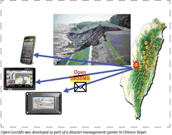
Aware of the industry trends described at the beginning of this article, in Chinese Taipei the government-sponsored Industrial Technology Research Institute’s (ITRI) Information and Communications Research Laboratories developed a way for SMS-enabled handheld devices to exchange coordinates without manual entry. This specification soon came into wide use by a number of network operators and system integrators in the region, and ITRI brought the specification into the OGC to be made into the OGC Open GeoSMS international standard.
ITRI’s specification was developed with an important disaster management application in mind. In Chinese Taipei, dangerous debris flows of rock and soil are common because of steep slopes, unstable soils, earthquakes and monsoons.
ITRI’s spatially enabled SMS plays a role in a sophisticated system that was developed for monitoring debris flow conditions and warning towns when a debris flow is imminent or in progress. The monitoring is accomplished using a wide array of sensors that are programmed to send messages to officials and citizens via multiple channels, including Open GeoSMS.
Not-for-profit disaster relief organisations such as Ushahidi, InRelief, Sahana and Haiti SDI VGI are implementing Open GeoSMS. The Sahana platform for disaster management was created in response to the 2004 Sri Lanka tsunami. The Ushahidi crowdsourcing crisis information collection and map visualisation application was developed in 2007-2008 to help with the Kenyan crisis. Sinsai.info (https://www.sinsai.info) (Sinsai means earthquake disaster in Japanese) is a crisis-mapping site that used the Ushahidi platform for response to the Great East Japan Earthquake. It was launched four hours after the earthquake occurred.
The Open GeoSMS candidate standard was adopted as an official standard by the OGC’s international membership last year. The lightweight and easy to implement OGC Open GeoSMS Standard facilitates interoperability between mobile applications and the rapidly expanding world of geospatial applications and services that implement OGC standard service interfaces, encodings and best practices.
OGC Open GeoSMS is a very simple standard, but it can become a very important standard in the larger framework of standards that support information flow during a crisis – such as standards for registering geospatial information sources, protecting location privacy, allowing access to location data, accessing sensor feeds, and supporting logistics.
Members of the Open GeoSMS development team, working as GeoThings4, provide Android and iOS apps that, for example, enable Ushahidi users to send OGC Open GeoSMS formated messages as incident reports5. The Android app supports photo sync to enable a user to submit a report first, and then sync their photo with the report when sufficient wireless bandwidth is available6. Another of their apps, ‘Find Me Maybe,’ enables users to submit Open GeoSMS posts to Facebook or Twitter, which is helpful when there is limited access to mobile Internet during a disaster7. A similar free app supports the US Federal Emergency Management Agency (FEMA) message service8.Another disaster management app from GeoThings attaches a satellite image based on a location provided by an Open GeoSMS query.
As Iqbal Quadir noted, “connectivity equals productivity.” As the GeoThings apps demonstrate, because Open GeoSMS is an OGC standard, it is part of an open standards infrastructure that provides connectivity between many geospatial resources. This openness greatly multiplies the standard’s utility.
A message delivered via Open GeoSMS indicates to a server or client that it is encoded using the well-known Open GeoSMS interface, and thus the location and related information can be easily translated into the OGC Geography Markup Language (GML). GML is a robust and rich specification that enables encoding and communication of any geospatial content. Both an OGC standard and an ISO standard, GML has been harmonised with a variety of other international standards. It has been broadly implemented in both proprietary and open source applications. All the major GIS vendors support the ability to generate and ingest GML documents.
In addition to the 39 standards that the OGC has provided so far to the world community, the OGC works with OASIS, IETF and many other standards development organisations to make geospatial information and services an integral and fluid part of the world’s information infrastructure. Such liaison work is critically important in providing a comprehensive interoperability platform for location communication, and for a range of important community uses including emergency response and disaster management.
Emergency and disaster management – OGC plays an active role in the OASIS Emergency Management Technical Committee, which works to advance the fields of incident and emergency preparedness and response. This committee developed the Common Alerting Protocol (CAP) and Emergency Data Exchange Language (EDXL) OASIS Standards. OGC members helped define a GML application for use in CAP and EDXL, as well as in other specifications under development, including the Hospital Availability Exchange (HAVE). CAP has rapidly become the alerting protocol that almost all crisis and disaster managers are using or migrating towards. Open GeoSMS works with CAP.
Aviation information management – GML is part of AIXM (www.aixm.aero), the international standard for the representation and exchange of Aeronautical Information Services (AIS) data. GML is also part of WXXM, the Weather Information Exchange Model, which has been proposed as a standard for the exchange of aeronautical weather information in the context of a global interoperable Air Transport System.
Information security – The recently approved OGC GeoXACML standard represents a spatial extension of the XACML (eXtensible Access Control Markup Language) OASIS Standard. GeoXACML provides for interoperable exchange of geospatial information access rights. It also provides a standard policy language to declare and enforce such access rights in a flexible way.
Harnessing sensor assets – The OGC’s Sensor Web Enablement (SWE) standards reference CAP and other relevant OASIS alerting standards including the OASIS Web Services Notification (WS-N) and Asynchronous Service Access Protocol (ASAP) specifications. The OGC works with OASIS to harmonise these standards with SWE specifications. SWE standards provide a way to harness the vast array of sensors, fixed and mobile, that can significantly improve situational awareness for a range of needs such as EM/ DM.
Mobile/ Internet – GML can also be used to encode geospatial data for lightweight applications that work at the level of the Internet that underlies the web. This is the case with the GML application schema in the Internet Engineering Task Force (IETF) Presence Information Data Format (PIDF-LO) standard for location payloads. PIDF-LO, designed for communicating privacy-sensitive presence information, is being incorporated into numerous other Internet standards, such as those for managing the electric power grid.
The connection to defence and intelligence
Almost every information technology application – planning, emergency response, intelligence, logistics, etc. – involves geospatial information. Almost every asset and every threat, natural or man-made, has a location or an area. Defence, intelligence and public safety systems are diverse and networked, so if personnel are to effectively develop and share awareness of assets and threats, geospatial information and geospatial processing instructions need to be easily and seamlessly accessed and moved freely between different information systems, including personal communication systems.
The OGC Open GeoSMS Standard can provide the geospatial connection between cell phones and a nation’s emergency and disaster management and defence and intelligence information infrastructure, helping to connect individuals to organisations. Preventing and dealing with conflicts in populated areas requires real-time geospatial intelligence focused on the activities of individuals, not platoons. Cell phones are essential resources for communicating with civilian population and with operatives and soldiers.
Defence and intelligence organisations and contractors have played an important role in the international process of developing OGC standards, and OGC standards play an important role in their information system architectures. Geointelligence, however, is a function that is critical not only to national defence and intelligence, but also domestic security, which includes anti-terrorist activities as well as disaster management and emergency management. There are no clearly defined seams between these activities and activities such as public health, transportation, and infrastructure planning. Open standards that enable cross-jurisdiction, cross-community and cross-domain communication are essential requirements in addressing the full range of complex issues facing government, businesses and society today. The OGC Open GeoSMS Standard extends the global geospatial information sharing platform, building the network at its ‘edge,’ increasing the granularity and precision of geointelligence.
- Peter H. Diamandis and Steven Kotler, Abundance – The Future is Better than you Think, 2012, Free Press.
- “Moore’s law is the observation that over the history of computing hardware, the number of transistors on integrated circuits doubles approximately every two years.” https://en.wikipedia.org/wiki/Moore’s_law
- https://en.wikipedia.org/wiki/Mobile_phone_tracking
- https://geothings.tw
- https://blog.ushahidi.com/index.php/2012/12/21/happy-holidays-from-ushahidi/
- https://geothings.tw/post/35189456432/find-me-maybe


