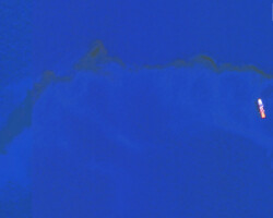
Oil spillage in the oceans is not only creating irreversible damage to the ocean ecosystem, but also adding extra weight on the limited natural resources and its extraction process. The satellite imagery from different sources majorly help in taking timely decisions to clean up the ocean beds and rescue operations are launched.
On 28 August, the aging freighter Sea Bird ran aground and sank after hitting Greek islets in the Aegean Sea. The cargo ship was on its way from Ukraine to Tunisia and at around 0300 hours local time, Sea Bird hit the rock about 0.2 nm to the northeast of Karavia, according to the Hellenic Coast Guard. There after the vessel sank immediately, and the 16 crewmembers abandoned the ship successfully.
On 29 August, the European Maritime Safety Agency has activated the pollution-control vessel Aktea to respond to the casualty and three additional anti-pollution boats, three privately-contracted tugs have also been participating in the clean-up effort.
European Space Imaging collected images over the area with the Maxar WorldView2 and WorldView-3 satellites. The imagery shows an extensive oil spill, measuring more than 20 sq km, within the vicinity of the ship’s last Automated Identification System (AIS) transmission and the current clean-up efforts underway.


