
China is steadily improving its strategic importance globally by strengthening its economic, technological, and military base. Several Chinese strategies are least bothered about justice or any international law. It has raised disputes with neighboring countries like India, Japan, Vietnam, the Philippines, etc.
On the other hand, China is constantly challenging the US and its allies by rapidly increasing military capacity in Air, Land, and Water. However, in past years Space has been its favorite weapon from the armory. In 2020, China was second to the US with 35 successful orbital missions; the latter had 40 successes. This year China has already launched 55 satellites; the majority of these are EO satellites.
China’s Space program is more military than one might think. From the launch sites to satellites, nearly everything is run by the People’s Liberation Army (PLA), so much so that all taikonauts are active members of the PLASSF.
While China is on its imperialistic Space journey, here are few satellite imagery showcasing its mischievous activities that are leading to significant geopolitical turmoil:
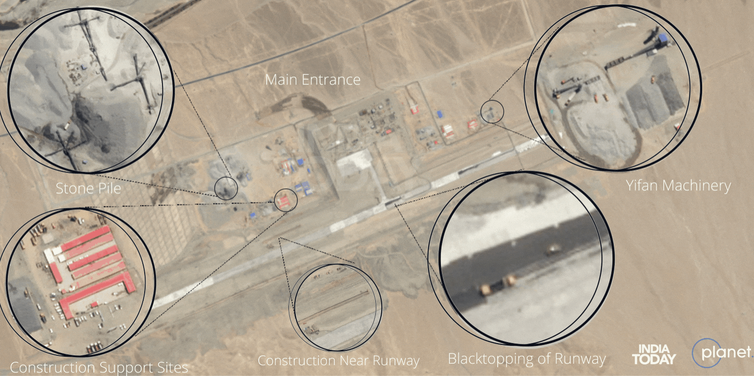
1. Protected underground facilities at the airport in Tashkurgan
Recent high-resolution satellite images by Planet suggest that China is developing underground facilities at the airport in Tashkurgan. Analysis by India Today confirms the likely dual-use nature of the upcoming airport. Along with the underground facilities, there is construction on other parts of the airbase. Blacktopping of the runways and structure of the terminal area, along with deployment of stone crushing machines, land moving equipment, and construction trucks, is visible in the imagery.
The strategic importance of Tashkurgan
Tashkurgan is near the borders of Tajikistan, Afghanistan, and Pakistan-Occupied Kashmir (PoK). China, which has an apparent vested interest in the region as it has heavily invested in the China Pakistan Economic Corridor (CPEC), part of the Belt and Road Initiative (BRI), will have an edge due to the strategic location of the airbase in Tashkurgan. Portrayed as ‘civil purpose or tourist,’ the airport holds more strategic value than the tourist spot given the few Chinese tourists visiting these areas.


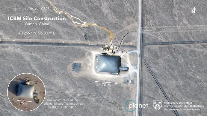
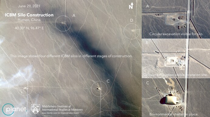
2. Nuclear missile silos in a desert
China is constructing more than 100 new silos for intercontinental ballistic missiles in a desert near the northwestern city of Yumen. Researchers from the Middlebury Institute of International Studies (MIIS) used Planet’s satellite imagery to discover the construction of 119 intercontinental ballistic missiles (ICBM) silos in China. The imagery clearly shows work underway on a grid covering hundreds of square miles of arid terrain.
Also Read: Before and after: Satellite imagery of Gaza conflict
As per The Washington Post article, “each site is separated from its neighbors by about two miles, and many of the sites are concealed by a large, dome-like covering, following a practice observed at known construction sites for missile silos in other parts of China. At sites where the dome is not in place, construction crews can be seen excavating a characteristic circular-shaped pit on the desert floor. Another construction site appears to be a partially built control center.”

3. New combat aircraft carrier at Jiangnan Shipyard, Shanghai
Satellite imagery by Maxar Technologies reveals that China has made considerable progress in building its third aircraft carrier, known as Type 003. The Center for Strategic and International Studies (CSIS) analysis shows that the construction of the aircraft carrier cabin is almost complete. In addition, the new vessel that is taking shape at Jiangnan Shipyard, Shanghai, will have three channels for the operation of its catapult launch system, each with 105 meters. The length of the new ship is approximately 318 meters, making it larger than both of its predecessors, Liaoning and Shandong. Earlier in June, the CSIS experts wrote that the vessel is expected to “be a formidable addition to China’s navy and allow it to more effectively project power” when it finally enters service.

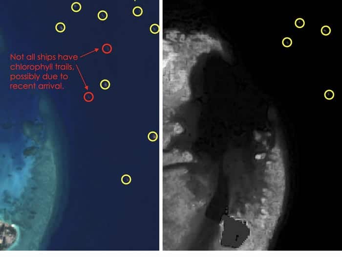
4. Dumping poop around the Spratly Islands
The satellite images taken over five years (May 14, 2016-June 17, 2021) confirms that more than 200 Chinese fishing ships are discharging raw sewage around the Spratly Islands in the South China Sea, which is causing extensive damage to coral reefs and marine life. Simularity, a US satellite imagery analysis company has come up with a report that shows a stark contrast in alga growth in five years. The researchers found that 236 Chinese vessels were recorded motionless in the waters during that period. The report says, “The hundreds of ships anchored there are dumping raw sewage, every day onto the reefs they are occupying. Excess sewage encourages the growth of phytoplankton in the water, which can cause oxygen shortages. Without adequate oxygen supply in the water, coral reefs and marine habitats can die, creating a dead zone”.
Also Read: Libyan Civil War: A reality check through VHR satellite imagery
There is a geopolitical significance to this catastrophe as five countries (Philippines, Malaysia, Vietnam, and Indonesia), including China, lay claim to islands in the South China Sea. In 2016, the International Court of Justice, or The Hague, rejected China’s claims in the South China Sea. The Philippines said it is in the process of verifying Simularity’s report.


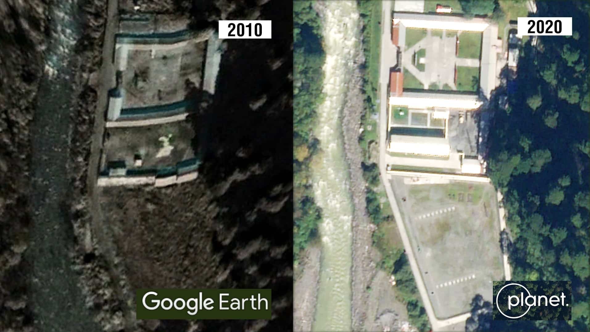
5. Building village in India
Planet’s satellite imagery shows that China has constructed a new village in Arunachal Pradesh, India, consisting of about 101 houses. The village, located on the banks of the River Tsari Chu, lies in the Upper Subansiri district, an area long disputed by India and China and has been marked by armed conflict. The construction is approximately 4.5 km within the Indian territory of the de facto border. Though part of India, the area has been under Chinese control since 1959.
As per the NDTV analysis, the imagery of November 1, 2020 shows the Chinese construction whereas the image dated from August 26, 2019 does not offer any construction activity. So, the village was set up in late 2020. Google Earth images also indicate that the village lies south of the McMahon Line, the boundary between Tibet and India’s Northeast region; however, Beijing disputes this line.


Also Read: Exclusive: Satellite imagery and RF mapping confirm Chinese build-up at Galwan Valley


