
Introduction
Electricity distribution and GIS
The use of GIS in power system has greatly enhanced the efficiency in energy sector. Proximity to the furthest customer and high cost to invest capital, are the reasons that make the distribution system as an important part of electrical utility, which endeavor to improve the reliability of general power system. Analyses such as selection of suitable areas, optimum path finding, the profile analyses, the engineering design of wires and towers, and the cost estimation can all be done using GIS.
Electric utilities are realising the benefits of GIS technology in the management of facilities for engineering, construction operations, and maintenance and services purposes. Problems of planning in distribution system can be solved by using new methods and specific techniques. Complexity of electrical distribution system and necessity of accurate up-to-date information of the network assets is a reasonable intention for introducing new method of information technology.
This study is meant to improve the understanding and networking of electricity power distribution towards effective power distribution. Most importantly, the power industry is expected to keep track of the electrical facilities (poles, circuits, power lines and transformers) involved in the distribution of energy to the end-users. With the aid of GIS, variety of information can be better organised on a computer system linking the database to an output map. Emengini (2004) noted that knowledge about physical assets of the enterprise is necessary to make strategic and operation decisions. Thus, to take wise decisions vital to the operations, growth and management of electricity distribution facilities, information must be collected and analysed to its full extent, such information contributes not only to efficient services, but also to the operation and maintenance of assets, and to the sensible planning of extensions and new works. This information helps in spatial decision making and it makes the information easily updateable and can cater for the needs of maintaining large power infrastructure. GIS can effectively be used to manage and monitor information on the distribution of electricity to end-users including information describing their spatial and non-spatial attributes such as geographical location and electricity use.
Aims and Objectives
The aim of the project is to generate a geospatial model for electricity consumers and facilities to provide a better understanding towards effective distribution and conservation of electricity. The objectives of the study are to:
- Carry out an appraisal of the existing electrical distribution network in the study area
- Map the existing electricity distribution facilities in the study area
- Estimate the trend in electricity consumption pattern in the study area
- Conduct gap analysis of electricity requirement in the study area
Methodology
Data acquisition
The data acquisition began with the physical phenomenon to be measured. The first step in the methodology of this work was the collection of the required data from the study area. In this case, there were two types of GIS data involved which included: spatial and non-spatial data.
Spatial data
The spatial data used for the research study include the following;
- Base Map: The base map consists of roads, buildings and facilities digitised from a High-Resolution Image data
- GPS Data: GPS Collection points on the available PHCN (Power Holding Company Nigeria) facilities (Poles, Transformers, etc) are acquired from the field of study using a Hand Held GPS.
Non-spatial data
The non-spatial data includes the following information which was acquired from the PHCN (Power Holding Company Nigeria), Ife District Office and consumers;
- Consumer Details: Meter Account Number, Address of the consumer, the Line Transmission Pole/Pillar to which a consumer is connected
- Electrical Network Details: 11kV line diagrams with cable sizes, lengths, distribution substation (DSS) transformers, parameters of the equipments, pillars, poles and low voltage networks
- Transformer Details: The details about transformers and other related facilities
For this study, PHCN (Power Holding Company Nigeria) bills were acquired so as to acquire information on the average amount of energy consumption.
Database design, creation, processing and analysis
Database design is the process of producing a detailed data model of a database. This data model contains all the needed logical and physical design choices and physical storage parameters needed to generate a design in a Data Definition Language, which can then be used to create a database. A fully attributed data model contains detailed attributes for each entity (www. en.wikipedia.org/wiki/Database design).
The database in the cause of this study supports an object-oriented vector data model. In this model, real world entities were represented as objects with their various properties, behavior and relationships. In GIS, a database is often referred to as a spatial database or geodatabase and it is the heart of GIS. This process involved the analysis and modeling of real world entities and their interrelationships in such a way that benefits were derived while utilising minimum amount of data.
Data were formally entered into their respective tables, created in Arc Catalog, in the Arc Map environment. After the data entry process, the personal geo database was saved in Arc Map in a folder for easy recovery, geo spatial analysis and queries carried out on them. The data stored in the database forms the information base. Once the layers were digitised, the non-spatial data were then added as attributes to the digitised features. This attribute table was linked to the spatial themes containing geographic information. The database created included location and descriptive information for all the different components of the system.
To estimate the areas in the study area that were of short comings in terms of the distribution and develop an estimation trend in the consumption of electricity, the following were operations carried out during the course of this study; overlay operations, spatial queries, proximity analysis and measurement of electricity consumption trend pattern.
Literature review on electricity distribution and GIS
Relevance of GIS in electricity distribution
GIS is one of the most important new technologies in power utilities which consider growth opportunities for fault analysis, optimisation of networks, load forecasting, cost estimation and selection of suitable areas and etc.
On viewing the requirements already stated, the question may arise that any normal database management system will do the job. But the electrical distribution system has a spatial dimension to it, which calls for the need of GIS. The Geographical Information System can handle both spatial as well as non-spatial data, which makes it more beneficial over the traditional database. Moreover GIS has the functionality of having information as layers, which helps in a systematic and refined manner of managing voluminous data. The spatially referenced data provides useful reference for setting up of new facilities, necessary information on land use pattern for planning optimum expansion of network and other network operations and maintenance. The database can also handle non-spatial queries as done with any other normal DBMS.
High customer demands force different kinds of technologies and skills to be banked upon by utility companies in order to enhance the level of production. For this reason GIS has become in effect, one of the tools for generating, arranging and managing geospatial information. Sipes (2007) shows a transition in recent years from the ways in which utility companies which have previously been engaging GIS as departmental solution to an enterprise solution where data is accessible by thousands of people.
Korte (2001) demonstrates that GIS can be employed to some extend in network tracking to determine a particular path or route through a network. This however supports the fact that GIS could be employed in agencies that regulate networked services. This can therefore be used as an important tool in distribution power industries to determine the power distribution capacity of the system along the way or perhaps to determine the most favorable path alone a straight network.
Above all the greatest supremacy of GIS is visualisation. The entire electrical network can be visualised as it is laid on the ground. Just by looking at the map and clicking at a particular feature (say a transformer), all the information (both location and engineering information) is displayed. This provides a more flexible understanding of the network and hence a faster approach to the solution.
However, GIS are not only computer systems designed to produce maps, but also powerful tools of geographical analysis. GIS can be defined as integrated sets of hardware, software, databases and processes designed to gather, preprocess, analyse and visualise data susceptible to be spatially located and related.
Geospatial techniques in distribution network model
Geospatial modeling is one of the most recent technologies which consider growth opportunities for fault analysis, optimisation of networks, load forecasting, cost estimation and selection of suitable areas.
Database which is the most important asset of an organisation plays a central role in the operation of planning, can be divided into two main various data types: spatial data that describe the location and the shape of geographic features and spatial relationship of map features. Attribute data known as descriptive information of the map features. The two most frequently used GIS models of spatial data are raster and vector. Vector data are based on co-coordinating the system where geographic object is represented by points, lines and polygon. Vector data are more suitable for features that have discrete boundaries such as roads. Raster data consists of a regular grid of cells or pixels where each cell has an individual value that in the coordinate system the cell size indicates distance and geographical position of objects. Each set of cells constitute a layer which called coverage and several thematic layers can logically constitute a complete database .The raster data model is the most suitable format for arithmetic operations among cells. A mathematical procedure called topology is used for representing spatial relationships among the objects.
GIS software and hardware are used as tools for storing, analysing, interpreting, updating, displaying information, professional’s designs and maintaining the system. Utilities worldwide use GIS to manage and map the location of millions of miles of overhead and underground circuits. Within GIS, your utility’s assets can be linked directly to your customer information system, allowing you to proactively monitor work orders, vegetation management, and outages.
GIS enables distribution utilities to identify vulnerabilities that cause outages, to weigh asset investments, and to understand customer satisfaction. With a rich set of easy-to-use spatial analysis tools, GIS helps you determine the right location for new facilities and new technology such as smart grid sensors and smart meters.
Research findings
Nature of electricity distribution network in the study area
Figure 1 below shows the map of electricity distribution network in the area of study. The map displays the geographic location of all the facilities in the selected area of interest. The entities identified included the Low Tension Electric Poles, High Tension Electric Poles; high and low tension cables, Distribution substation transformer, power transformers, feeders and Injection Substation. Figure 2 shows a more detailed map of the electricity distribution facilities connected to the end consumers.

Fig 1: Electricity Distribution Network Map

Fig. 2: Map showing the facilities involved in the distribution of electricity to consumers
Information showing all the facilities involved in the service of electricity to the consumers in a selected part of the area of interest is shown in Figure 2 above provide a better understanding of the electricity distribution network pattern.
Spatial queries generation
In GIS, a spatial operation tool is essential for processing or manipulating of data to suit user”s need. Geographical Information Systems have a distinctive disparity from other Information Systems which is in the area of spatial analyses. In this project, the spatial search operation was carried out through query generation to retrieve the information stored in the database pertaining to certain systematically defined attributes within the database to answer spatially related questions. This operation involved the link between the database and the map of the selected area of interest. Spatial queries were generated to provide answers to the application use of GIS in developing a model (representation of reality) for the PHCN facilities.
Database query can be referred to as the selection of various combinations of various tables for examination; it involves the retrieval of information stored in the database using structured query language (SQL). However, the queries generated are basically through database extraction in ArcMap 9.3. Some other queries can also be generated based on the user”s need. In the course of the project, the results obtained have assisted in the several areas;
- Monitoring the status of the facilities in the Feeder so as to know the status of the facilities.
- Retrieval of Geographical Information of the facilities. The spatial information would include coordinates (X and Y), and symbol representation, capacity and location.
- Prioritisation of facility replacement based on the available information. In this study, of all the existing facilities on ground, none was due for immediate replacement.
- Update the information system in the case whereby new facilities are to be installed. In the near future, when new buildings are connected to the existing facilities, the information system can be updated.
Figure 3 suggests proposed location for the installments of new Distribution Substation Transformers within the study area. This was generated based on the average consumption rate by the existing households and the amount of Power generated by each distribution substation transformers connected to them.
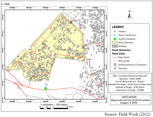
Figure 3: Map showing existing and proposed location of DSS
The above results are expected to equally provide good information for other professionals, which may include Urban Planners, Construction Managers, Engineers, etc. the knowledge of the locations (spatial locations) of the facilities will help to avoid or reduce damages done to these facilities during construction works especially in newly developed areas (such as, Parakin).
Proximity analysis and estimation of consumption trends
Other analyses were carried out during the course of this work. Proximity Analysis such as Buffering analysis was carried out to identify the areas for the requested availability and quality of energy supply. As shown in Figure 4 below, the buildings connected to a particular transformer (DT5 in this case) that fall outside a 300m radius experience a drop in voltage compared to those within the buffered area. The buffering analysis performed helped in identifying the pattern of the supply and distribution of power in terms of voltage within the study area.

Figure 4: Selected Buildings with estimated drop in voltage
In the case of Figure 5, the result displayed was based on the average consumption rate of the house-holds within the study area. Based on the level of consumption, it clearly shows that most of the households within the area of interest were classed as residential houses. The results displayed show the variation in the energy consumption rate within the area. This is because of the various types of electrical appliances used by different households within the area. As represented in the map displayed, the Buildings with darker colors consume higher consumption rate than those with brighter colors.

Figure 5: Rate of consumption of residential households
In order to estimate the consumption trend during the course of this work, other analyses were performed. The relevance and importance of mapping utilities in GIS environment is to provide spatial solutions in a real time manner. The common problems that have been identified in the Power Utility Sector include the following;
- Unequal distribution/transmission of load
- Bad conditions of the equipments due to improper monitoring and maintenance
- Frequent power surge due to natural incidences
It was been observed that in the study area electrical facilities are either obsolete or too old for efficient performance. Therefore, routine maintenance and replacement are necessary for efficient performance the electrical equipment in the study area. The threshold of each electrical facility should however be noted at installation and strictly adhered to during operational period. In advanced GIS, locating the facility and finding the exact fault wherein it has occurred could be substantiated by hand held palmtops. The notified location on the spatial network wherein the fault has occurred could be easily identified and trained engineers could be alerted to go to the exact area and rectify the problem immediately. This showed that the major advantage of GIS in Electricity distribution network is the location component.
The electricity distribution network map of the study area revealed the spatial distribution and locations of the electrical facilities within 11kV feeder in the area of interest. In the course of this work, it was observed that electricity consumers within a 300meter radius to a distribution substation transformer, experience higher voltage of power compared to the households outside the radius. It was however noted that about 55% – 60% of households connected to the distribution substation transformers experience average voltage of power supply while about 40% – 45% experience drop in voltage of power supply. The gap analysis showed that, voltage drop in power supply is experienced the farther the households are connected to a distribution transformer.
As shown in figure 5, the system shows descriptive information about the households and their average rate of consumption. This clearly reveals the consumption rate pattern within the households connected to all the facilities within the area. Within the network, 37% of households consume high amount of electricity, 36% consume average and 27% consume less amount of electricity.
The spatial analysis and the resulting maps provided a better knowledge and understanding on spatial relationships among electricity facilities and consumer demands. Such knowledge is expected to help them know the sections of the service area that lack inadequate services. It is also expected to serve as a guide to them in order to know where they could extend or improve their services and areas that need new installation based on the distribution of power.
Conclusion and recommendation
The study clearly indicates the capability of spatially enabled information system in the management of electricity distribution network. Spatial and attribute data of power distribution network of any part of the selected areas of interest of this study, which are presently acquired, processed, managed, stored and presented in analogue form, can be digitalised. Ayeni et al., (2003) noted that Geospatial Information (GI) is very essential to economic planning and national development. This is buttressed further by Alamu and Ejiobih (2002), when they concluded that a well maintained utility information infrastructure gives up-to-date information on what is where, the state of it, the reaction other actions on it would cause, how it can be harnessed for optimum use of the people and economy. It has been shown that GIS has been employed as one of the technologies for better and improved delivery of networked services. This further enlightens that regardless of cost, GIS has prominently improved the manner of service delivery with respect to time period.
Conclusively, it has been observed that GIS applications have not reached the optimum exploration and there is still room for further exploration and extension in the field as far as utility service delivery like in the case of electricity distribution is concerned.
The following recommendations are advanced for efficient electricity distribution networks;
- More efforts must be made to bring in refined and scientific approaches such as Geographic Information Systems into the management of electricity distribution network.
- Training programs should be organised for technical online staff of electricity distribution on the integration of GIS in the management/monitoring of electricity distribution.
- The user requirement and survey analysis conducted before implementation of electricity projects should include spatial information system from the onset so as to forestall drop in voltage within the distribution network.
- Establishment of more distribution substation transformers in low voltage area within the study area.
REFERENCES
- Alamu, E. O. and Ejiobih, H. C. (2002). Utility Information Infrastructure Needs in Utility Organisations in Nigeria: A Case Study of Niger State Water Board. Proceedings of the Technical Session of the 37th Annual General Conference and Meeting of Nigerian Institution of Surveyors, Owerri, Imo State, Nigeria, pp. 85-88.
- Ayeni, O. O., Kufoniyi, O. and Akinyede, J. O. (2003). Towards a National Geospatial Information Policy for Nigeria”, Proceeding of the Technical Session of the 38th Annual General Conference and Meeting of Nigeria Institution of Surveyors, Lokoja, Kogi State, Nigeria, pp. 21.
- Douglas, D. H., (1994), Least Cost Path in GIS Using an Accumulated Cost Surface and Slope Lines. Cartographica 31 (3): 37-51.
- Emengini, E. J. (2004). Application of Geographic Information System (GIS) to Utility Information Management: A Case Study of Onitsha-North L.G.A., Anambra State, Nigeria. Unpublished M.Sc. Thesis Submitted to the Department of Surveying and Geoinformatics, Nnamdi Azikiwe University, Awka, Anambra State, Nigeria.
- Ezeigbo, C. U. (1998). Application of Geographic Information Systems (GIS) to Utility Mapping, in C. U. Ezeigbo (ed.), Principles and Applications of Geographic Information Systems, Lagos, Panef Press, pp. 124-131.
- Korte, G (2001). The GIS book: how to implement, manage and assess the value of Geography
- Kufoniyi, Olajide (1998). Database Design and Creation in C. U. Ezeigbo (ed.). Principles and Applications of Geographic Information Systems, Lagos, Panef Press, pp. 1-15.
- Sipes, J. L. (2007). Spatial Tech- GIS for the utilities Industry. Cadalyst Publications
- www.usgs.com
- www.gis.rgs.org


