
Takaaki Namatame, Hirofumi Chikatsu
Department of Civil Engineering
Tokyo Denki University Hatoyama,
Saitama, 350-0394, JAPAN
Tel:+81-492-96-2911
Fax:+81-492-96-6501
E-Mail: [email protected] , [email protected]
Abstract
Reconstruction of lost historical city or spot has recently received more attention from a possibility that people can appreciate or experience the historical space through the computer. In general, great deal of time, labor and skill are needed to reconstruct 3D historical objects. In particular, 3D modeling of buildings are important issue since buildings are an important component of historical city model.
This paper describes an efficient city modeling method for visualization of historical city, and visualization of historical spot, around Hakone Barrier Station is demonstrated.
Introduction
Existing colorful historical maps were mostly produced at the Edo period in Japan, and these historical maps which show situation of land use and streets in those days often give important information for studying history of city planning, civil engineering, architecture and so on. In particular, visualization of historical city helps to make understanding for situation at the time when the maps were produced more efficiently. On the other hands, virtual archeology has recently received more attention from possibility that people can appreciate or experience the archeological objects or historical space and art through the computer at any time and without going to the museum.
The efficient method for visualization of historical city using the historical maps was proposed by the authors (Namatame & Chikatsu, 1999), and the remarkable points of this method were its ability to arrange each building on the historical map automatically. Hakone locates near Mt. Fuji, and Hakone barrier station was the most important station for the Edo period since the Japan was divided into two territories at the time. As Hakone barrier station was lost, only the sits remain, Hakone Barrier Station is reconstructed from the view point of digital archive and VR museum, and visual simulation around the Hakone Barrier Station is demonstrated in this paper.
Efficient City Modeling
- Extraction of Dwelling Area
- Reconstruction of City Model
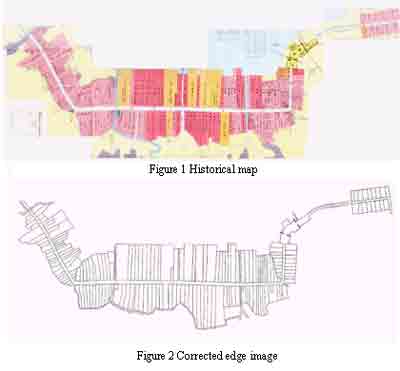
Figure 1 shows historical map used in this paper. The historical map is around the Hakone Barrier Station, and the circumference for each attribute data such as inns is drawn by black line in this map. The extraction method of the attribute data using mathematical morphology and remapping method were described by the authors (Yamada & Chikatsu 1999). However, extraction for small characters included dwelling area and insufficient clarity color were issues. Then, in order to acquire information for dwelling area such as position, area, height and width ratio, kind of dwelling area, firstly black lines in figure 1 are extracted using Gauss-Laplacian(GL) filter and extracted lines are corrected by manual. Figure 2 shows the corrected edge image. Secondly, position, area, height and width ratio for dwelling area are acquired by labeling procedure.
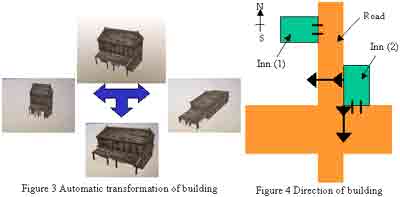
Dwelling area for two kinds of inn can be recognize using figure 1 since dwelling areas were classified by two colors. Then, two basic 3D models for the typical inn are reconstructed previously using 3D CG, and recognition for each inn is performed using the position for the dwelling area and color information. The size of inn is transformed automatically using height and width ratio for dwelling area (Figure 3), and direction of each inn is also decided automatically so that the front of inn faces toward the road. Furthermore, inn faces toward the wider road when inn faces toward two roads. For example, inn (1) faces toward the east, and inn (2) faces toward the south shown in figure 4. Figure 5 shows the reconstructed city model by this procedure.
- Reconstruction of Typical Model
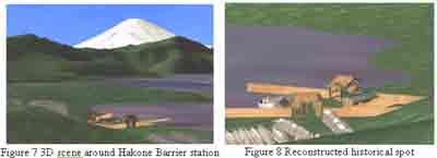
Generally, barrier station was build at pivot point of traffic and had important role such as a present passport control. Barrier station was a special objects at an area, then it is needed to reconstruct by one by under historical investigation. Figure 6 shows 3D model for the Hakone Barrier station reconstructed by manually, figure 7 shows a scene around Hakone including Mt. Fuji and Ashino lake using digital data published by Geographical survey Institute. Furthermore, utilization of Internet and VR techniques to facilitate promotion of cultural heritage is one of the terms reference of ISPRS WG V/4 (Image analysis and spatial information systems for applications in cultural heritage). For this goal, the visual simulation are opened at following web site: , and figure 8 is one of scene of the visual simulation.


Conclusion
3D Modeling method for recreating historical spot was described in this paper, and the remarkable points of this system are as follows:
- Automatic recognition of the dwelling area.
- Automatic reconstruction of the buildings.
- Automatic 3D modeling of historical city.
- Reducing time and labor can be achieved.
- Promotion of cultural heritage is expected through internet visual simulation.
As the results of these, it is concluded that city modeling method described in this paper is an efficient method for reconstruction of historical city. However, automatic edge detection for circumference of dwelling area still issue as a further work.
Reference
- Namatame T., Chikatsu H., 1999. Approach to Efficient City Modeling for Visualization of Historical City, International Archives of Photogrammetry and Remote Sensing, Vol. XXXII, Part 5-3W12, pp.21-23
- Yamada N., Chikatsu H., 1999. REMAPPING OF HISTORICAL MAPS USING MATHEMATICAL MORPHOLOGY AND APPLICATION, International workshop on Mobile Mapping Technology, p2-6-1 – 2-6-5


