On September 8, 2023, a powerful magnitude 6.8 earthquake struck Morocco, causing widespread damage that has killed more than 2,100 people and left remote villages near the epicentre in ruins. The epicentre of the quake was located in the High Atlas mountain range, about 72 kilometres southwest of Marrakech. The 6.8-magnitude quake is the strongest to hit the region around the ancient city of Marrakech in a century, according to the US Geological Survey.
Maxar Technologies’ satellites have captured high-resolution imagery of the affected areas, providing a unique perspective on the aftermath of the disaster.


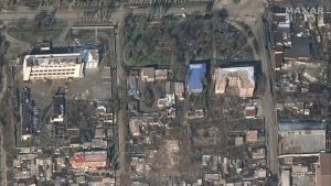
The areas that were most severely affected by the earthquake are visible as patches of brown and grey, indicating damage to buildings and infrastructure. The damage to buildings is extensive, with many roofs collapsed and walls cracked. Some buildings have been completely reduced to rubble. Debris can be seen scattered throughout the village, and roads have been blocked by fallen debris. The earthquake triggered a number of landslides in the mountainous areas around the epicentre.
Open Data Program
Maxar’s satellite imagery is playing a vital role in the earthquake response effort through its Open Data Program. In the program, Maxar releases open data for select sudden onset major crisis events. The imagery here is being used to assess the damage, map the affected areas, and track the progress of recovery efforts. The imagery is also being used to identify areas that are at risk of landslides or other hazards.
Emergency response teams are working around the clock to provide assistance to the affected areas. Medical teams are also providing care to the injured, and relief workers are distributing food, water, and shelter to those in need.
The recovery from the Morocco earthquake will be a long and challenging process. The government has pledged to provide financial assistance to those who have been affected, and international aid organizations are also providing support. However, it will take months, if not years, to rebuild the damaged homes, businesses, and infrastructure.