Home 2024 March 5

Daily Archives: 03/05/2024

Ubotica’s CogniSAT-6: Real-Time Earth Data via AI Satellite

0
Ubotica’s CogniSAT-6: Real-Time Earth Data via AI Satellite

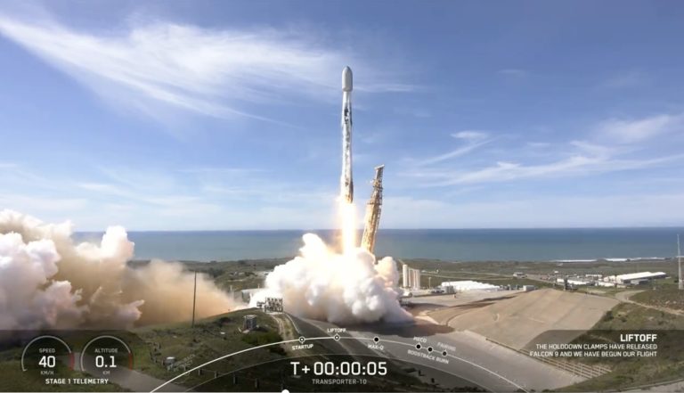
Ubotica, an autonomous SPACE, AI-enabled satellite technology company successfully launched its CogniSAT-6 mission onboard SpaceX’s Transporter 10. CogniSAT-6 will revolutionize Earth Observation, providing actionable Live Earth Intelligence for real-time decision-making.

Redefining Earth Observation

This mission leverages Ubotica’s partnership with Open Cosmos, who designed and built the satellite which is called Hammer (Hyperspectral AI for Marine Monitoring and Emergency Response). The CogniSAT-6 mission with the Hammer satellite marks a revolution in Earth Observation, combining onboard AI with live communications to stream Live Earth Intelligence directly to users. This unprecedented capability empowers immediate analysis and action across various industries. The mission combines several innovations:

Onboard AI unlocks Live Earth Intelligence: Traditional Earth Observation faces a critical limitation: images are captured and sent to Earth, where processing can take days. CogniSAT-6 revolutionizes this process by integrating onboard image processing and AI inference, bringing intelligence directly to the satellite to unlock real-time insights.

Hyperspectral vision: The high-resolution hyperspectral camera reveals the chemical makeup of objects. This information is crucial in applications like precision agriculture (crop health), environmental monitoring (pollution detection), and infrastructure assessment (material composition).

Continuous connectivity: Inter-satellite links maintain a real-time two-way data flow, enabling immediate transmission of actionable insights within minutes. Today, getting insights from space takes hours and days.

Autonomous intelligence: CogniSAT-6 analyzes data as it is collected, unlocking insights. For example, if an oil spill is suspected, the satellite can independently task other satellites for closer inspection.

Interactive insights: A dedicated mobile app allows users to interact directly with CogniSAT-6. Receive alerts, view tailored data, and send commands to refine observations in real-time.

Applications of Live Earth Intelligence

CogniSAT-6 has the potential to transform numerous sectors:

  • Precision agriculture: Farmers can monitor crop health, optimize irrigation/fertilization, and maximize yields with up-to-the-minute data.
  • Disaster response: Respond immediately to floods, fires, and other events, enhancing coordination and saving lives.
  • Maritime monitoring: Detect illegal fishing, track vessel movements, and improve maritime security with real-time intelligence.
  • Energy infrastructure: Monitor pipelines, power grids, and renewable energy installations, optimizing maintenance and preventing failures.

Fintan Buckley, CEO at Ubotica, commented:

“Just as AI transforms life on Earth, SPACE:AI will revolutionize how we understand Earth in real-time. CogniSAT-6 empowers users with Live Earth Intelligence, transforming how we interact with our planet. It combines onboard AI, real-time satellite communication, and adaptable observation strategies for immediate, actionable insights.”

Sean Mitchell, Chief Commercial Officer at Ubotica, added:

“CogniSAT-6 is the first satellite directly connected to users through a mobile app. This empowers users with real-time alerts and data tailored to their needs. The two-way communication allows them to send commands back to the satellite, requesting closer observations or directing it to new areas. This revolutionizes Earth observation, shifting from broad data collection to targeted, real-time problem-solving that addresses urgent user requirements.”

Open Cosmos Partnership

This mission leverages Ubotica’s partnership with Open Cosmos, who designed and built the satellite which is called Hammer (Hyperspectral AI for Marine Monitoring and Emergency Response). Sharing a vision for the disruptive potential of Space 4.0, this mission marks another successful collaboration between the two companies.

The HAMMER satellite will acquire, process, compress, store, and forward medium-resolution hyperspectral imagery specifically focused on the Atlantic coastal and maritime areas.

Oriol Aragon Casaled, Mission Manager at Open Cosmos said, “HAMMER truly is a game changer for Open Cosmos and a satellite that is sure to disrupt the market. The inclusion of a hyperspectral camera and AI board ensure the most advanced imaging in the market, while the inter-satellite linking makes data available in almost real time. This means our customers don’t have to wait days, or even hours, for insights from their areas of interest – they can get them in minutes. For us, HAMMER is setting a new standard for Earth Observation satellites.”

Digital Twin Fostering Collaboration between Government and Industry

Digital Twin Fostering Collaboration between Government and Industry

In an illuminative interview with Geospatial World, Dr Gaurav Singh, Head-Automation and Projects at Adani Group, sheds light on the significance of Digital Twins in India’s infrastructure development and the challenges and opportunities associated with their widespread adoption.

Transforming India’s Infrastructure Development

Digital Twins, at their core, create virtual replicas of physical assets and systems, intertwining various technologies to allow for seamless communication between systems.

This continuous flow of data provides real-time insights, fostering better decision-making across both public and private sectors.

The technology stands as a beacon for managing knowledge effectively, particularly in infrastructure projects where continuity among phases often lapses due to the change in personnel.

Dr. Singh emphasizes the revolutionary potential of Digital Twins in infrastructure projects,

He remarked saying, “Digital Twins can transform infrastructure projects by providing real-time, digitized data that is accessible to all stakeholders on-site. This innovation could prevent common issues such as accidental damage to utility lines during construction, showing the practical benefits of Digital Twin technology in day-to-day operations.”

The swift adoption of Digital Twins in India, spurred by Indian Govt. openness to technology, signifies a promising trajectory towards modernized infrastructure management.

Overcoming Challenges for Widespread Adoption

Despite the evident advantages, the widespread adoption of Digital Twins faces significant hurdles, primarily in change management. The technology’s implementation requires buy-in at all levels, not just from top officials and industry leaders.

Dr. Singh points out the necessity for seamless system communication, interoperability, and knowledge management as crucial elements in overcoming these challenges.

Addressing the discontinuity between project managers and operational staff in long-term projects, he states, “Digital Twins promise a seamlessly integrated system that ensures meticulous knowledge management and operational efficiency. Inclusive workshops showcasing the benefits would improve technology adoption across the board.”

The Role of Spatial Information

Central to the Digital Twin strategy is geospatial technology, described by Dr. Singh as the “backbone” of Digital Twins.

This technology layers information to visualize systems and guide decision-making. It’s indispensable in various sectors, including construction, energy, and urban planning, providing a foundation upon which modern development stands.

He adds on, saying,” Digital Twins rely on layers of information to visualize systems and guide decision-making. Whether it’s roads, airports, buildings, or entire townships, real-time geospatial data is crucial. You can survive without it, but you can’t thrive.”

The collaboration between government and industry is vital for driving progress in this domain. The release of the Digital Twin strategy marks a vital step forward, indicating a future where real-time data on resources, personnel, and infrastructure components are readily available.

Geospatial tech like Digital Twins, thus, becomes a cornerstone of this ambitious vision, highlighting its indispensable role in shaping the future of infrastructure development. By addressing the challenges and fostering collaboration, this technology can pave the way for a more efficient, data-driven future.

Avineon India Transforms Hong Kong into a Smarter City Through 3D Digital Mapping

0
Avineon India Transforms Hong Kong into a Smarter City Through 3D Digital Mapping

The Hong Kong government is working on making the city smarter through a pioneering 3D digital mapping project. Their goal is to improve urban planning, development, and disaster management.

The project has kicked off in Kowloon East, where they are creating detailed CityGML models for buildings and infrastructure to reshape the city. Hong Kong Lands Department, AECOM as consultant for data analysis and testing of the deliverables, and Avineon India Pvt. Ltd are the key stakeholders associated with the project.

Avineon India was entrusted with the job of processing and generating these 3D city models, playing a crucial role in shaping the city’s future. For this project, Avineon India was nominated and was one of the finalists in the Surveying and Monitoring category at 2023 Going Digital Awards In Infrastructure organized by Bentley Systems at Marina Bay Singapore.

Pramod Karnawat, Vice President, Business Development – Geospatial & IT, and Govardhan Goud Jutla, General Manager – 3D Geospatial Services at Avineon, in an exclusive interview with Geospatial World shared more insights on how they approached the project, talked about the challenges when integrating voluminous multi-sourced data into accurate representations of city infrastructure in a single digital environment, and how different solutions from Bentley Systems helped them solve the issues and complete the project in a successful manner.

What is the significance of this project?

In the pursuit of establishing a technologically advanced smart city in Hong Kong, the primary focus of the project was on crafting a top-tier 3D Digital Map. The project’s scope encompasses the creation of photorealistic textured 3D models for both buildings and infrastructure.

This project is extremely significant in the realms of urban planning, disaster management, infrastructure development, and the broader landscape of smart city applications. Its far-reaching impact spans across various facets of urban life, including urban planning strategies, initiatives to build smarter cities, disaster response preparedness, fostering public engagement, promoting tourism, and preserving the cultural heritage of the city.

In essence, this project emerges as a beacon of sustainability and an enhancer of urban liveability. The project has a substantial return on investment, leading to time and resource savings, reduced processing time, and cost reductions.

From a sustainability perspective, the 3D Digital Map is regarded as a fundamental element in the advancement of Smart City development and the evolution toward a Digital Hong Kong. It facilitates the sharing of geospatial data and contributes to the enhancement of the next generation of geospatial applications.

What significant hurdles did you encounter during this project, and in what ways did digital technologies play a role in overcoming them?

The project had three major challenges:

  • Integration and handling of data from multiple and diverse sources
  • Minimizing manual effort in data processing
  • Overcoming constraints posed by non-3D modelling software like GIS, CAD, etc.

The project involved amalgamating an extensive array of data from diverse sources, encompassing aerial imagery, LiDAR, mobile imagery, and as-built drawings. Each data type was collected in varying formats and at different points in time.

The adoption of digital technologies, notably Bentley’s MicroStation CONNECT Edition, facilitated the seamless integration of data from multiple sources and formats. These tools played a crucial role in preserving the geometric, topological, semantic, and appearance properties of the data during integration.

Leveraging digital tools streamlined the processing of LiDAR data, encompassing tasks such as eliminating erroneous points, classification, and the creation of highly accurate 3D representations of building roofs adhering to CityGML standards. This not only improved accuracy but also significantly reduced the time and resource investment.

Avineon India chose a semi-automated or automated approach, facilitated by modelling tools and templates within Bentley’s environment, which dramatically decreased the manual effort required for the project. To cater to the issues related to limitations of non-3D modelling software, the project leveraged dedicated 3D modeling software, such as Bentley’s MicroStation CONNECT Edition.

This choice provided advanced visualization, analysis, and 3D modelling capabilities, ensuring the creation of precise 3D city models while adhering to standards like OGC compliant CityGML. The incorporation of this specialized software mitigated issues associated with data quality and compatibility that might arise from using non-3D modelling tools.

How did the utilization of iTwin Capture Modeler and MicroStation contribute to guaranteeing the accuracy, consistency, and quality assurance of data in the creation of twins and 3D city models for Kowloon East? Furthermore, does iTwin Capture Modeler have the capability to integrate seamlessly with Bentley or third-party software tools?

In the development of 3D city models, the pivotal role played by iTwin Capture Modeler and MicroStation are indispensable in ensuring the accuracy, consistency, and quality assurance of data. These tools not only provide essential functionalities for aligning, validating, and managing data effectively but also contribute to the seamless collaboration and integration of data within the project.

Moreover, both iTwin Capture Modeler and MicroStation boast compatibility and integration capabilities with a diverse range of Bentley and third-party software tools. This ensures the smooth exchange of data and models across various applications and disciplines, fostering enhanced collaboration and interoperability within intricate projects.

What new elements can be introduced to enhance the services provided by the city administration? Additionally, what suggestions do you have for additional applications that can be implemented using this model?

Implementing a 3D digital mapping model, like the one deployed in Kowloon East, opens up numerous possibilities for city administration to elevate their services and introduce innovative solutions. Following are some recommendations for additional applications and services that can capitalize on this model:

  • Utilize the 3D model for more precise and efficient urban planning, enabling the simulation of urban growth and the assessment of proposed developments’ impact on the city’s landscape.
  • Integrate the 3D model with traffic data for real-time traffic monitoring and optimization of traffic flow.
  • Conduct model analysis for designing energy-efficient buildings and planning renewable energy installations.
  • Track air quality, noise pollution, and other environmental factors using the 3D model.
  • Employ the 3D model for disaster management and emergency response planning.
  • Provide virtual tours of the city using the 3D model.
  • Enhance infrastructure maintenance by identifying vulnerable areas through 3D model inspections.
  • Plan for the installation of safety features and measures.
  • Develop crisis management strategies by simulating various crisis scenarios, including natural disasters or pandemics.
  • Utilize the 3D model to attract investment and business development by showcasing available space and opportunities for development.
  • Implement sustainable waste management by optimizing waste collection and disposal, utilizing the model to identify optimal routes and locations for waste facilities.
  • Apply data analytics and machine learning algorithms to extract insights and patterns from the 3D model for data-driven decision-making.
  • Monitor public health by analyzing the 3D model for trends in disease outbreaks, healthcare access, and resource allocation.

How extensive is Avineon’s background in providing 3D geospatial services?

Avineon offers an extensive range of 3D services encompassing the processing of 3D source data and the modelling of 3D objects or assets at different levels of detail. Avineon’s capability includes development of 3D models in the form of CityGML 2.0 models, photo realistic models in various 3D formats including OGC Compliant CityGML. Our typical source data includes LiDAR point clouds, stereo-imagery, and oblique imagery—both aerial and terrestrial.

Avineon’s capabilities extend to aero-triangulation, orthophoto production, LiDAR point classification, and Digital Terrain Model (DTM) creation. Additionally, we specialize in constructing highly detailed, photo-realistic 3D city models at various levels of detail from LOD0-LOD4  for structures such as buildings,  and other infrastructure such as bridges, flyovers, tunnels etc. The LOD can be extended up to a Building Information Modelling (BIM) representation.

How do you see Bentley Systems’ platform and products aligning with your future plans and the capabilities you aim to achieve in addressing the changing requirements of your customers and projects? Are there any comparable products under consideration?

Bentley Systems’ platform and products hold a central position in our future plans, proving indispensable in meeting the dynamic requirements of our customers and projects. These solutions encompasses a diverse array of geospatial and infrastructure solutions crucial to our projects. Our reliance on these tools for data integration, 3D modeling, and geospatial analysis is expected to persist.

The visualization capabilities within Bentley’s MicroStation have significantly enhanced our proficiency in creating and analyzing 3D models. We intend to capitalize on these tools to elevate data representation and analysis in upcoming projects. Additionally, our projects heavily rely on Bentley’s solutions for robust quality assurance features. The continual use of Bentley products is anticipated to validate and uphold data accuracy and quality.

Moreover, to address the evolving customer requirements, we turn to Bentley’s platform for the scalability needed to adapt to new technologies, expand capabilities, and handle larger and more complex datasets. Bentley Systems’ track record of innovation in the geospatial and infrastructure sector positions us to leverage their future innovations and enhancements, particularly in response to the demands of smart cities and advancing technologies.

However, though Bentley’s products play a pivotal role in our work, we maintain an openness to evaluating similar products and solutions in the market, ensuring that we employ the most effective tools for our projects.


Hitachi, BluVein Partner to Electrify Mining Trucks

0
Hitachi, BluVein Partner to Electrify Mining Trucks

Hitachi Energy and BluVein, an innovator in dynamic charging technology, have signed a Memorandum of Understanding (MoU) to accelerate the electrification of heavy haul mining fleets and solve one of the biggest challenges in decarbonizing mine operations.

Hitachi Energy’s advanced power electronics and digital charging technologies allow BluVein’s e-rail charging technology to deliver electricity safely and reliably to haul trucks of up to 400 metric tons while transporting materials.

The collaboration will fast-track the development of a high-powered, fast and flexible dynamic charging solution for surface and underground mines and quarries in Australia and across the globe.

BluVein will focus on its leading-edge e-rail and connection of the truck, which Hitachi Energy will further complement with advanced power electronics and digital solutions to power and monitor the whole system.

“This strategic collaboration with BluVein will enable our mining customers to trial next-generation dynamic charging solutions vital for achieving net-zero emission targets without compromising on operating practices or productivity,” said Marco Berardi, Head of Grid & Power Quality Solutions and Service business at Hitachi Energy. “We believe this new collaborative approach will deliver on our common goal to accelerate the transition to all-electric mining and a carbon-neutral future.”

“This MoU supports BluVein’s mission of partnering with a technology leader to deliver a universal dynamic connector that facilitates the removal of fossil fuel from mines and helps propel the industry globally to meet its decarbonization goals,” said James Oliver, CEO at BluVein. “Together, we are helping the industry move to a more sustainable and responsible future.”

Hitachi Energy and BluVein are also exploring the off-vehicle hardware requirements for BluVein1 for underground and smaller fleets, while actively cooperating on BluVein Proving Grounds currently under construction in Queensland, Australia.

Drone spraying Boosts Paddy Farming Efficiency in Indian State

0
Drone spraying Boosts Paddy Farming Efficiency in Indian State
Image courtesy: Telangana Today

The farmers of the Kondapochamma Farmers Producers Organisation (FPO) located in Siddipet were spraying Nano Urea by employing drones quitting the traditional way of spraying urea fertiliser as reported by Telangana Today.

Agriculture Officer Markook Nagendar Reddy has said, “The efficiency of urea reaching out to plants will increase by 30 per cent if farmers spray the Nano Urea. Plants will use just 50 per cent of fertiliser in the traditional way of spraying.”

However, he has said that the efficiency will cross 80 percent if farmers spray Nano Urea employing drones which eventually enhances the paddy production.

Indian Farmers Fertiliser Cooperative Limited (IFFCO) has gifted the drone to FPO to encourage the Nano Urea spraying.

IFFCO Siddipet in-charge Chandrababu has said that the spraying will also restrict the environmental pollution. It will also address the labour shortage in the agriculture sector.

Rwanda, Poland Sign MoU on Space Technology

0
Rwanda, Poland Sign MoU on Space Technology

Rwanda Space Agency and the Polish Space Agency have signed a Memorandum of Understanding to advance partnership opportunities in space technology.

The MoU aims to leverage the robust Polish space ecosystem to develop collaboration on activities of mutual interest and solidifies the commitment of both nations to harness space capabilities in support of their development agendas.

It fosters interagency cooperation between industries and academia to advance capabilities in space technologies, facilitating knowledge transfer and promoting tailored research and development initiatives.

Col. Francis Ngabo expressed, “Rwanda is dedicated to leveraging space technology capabilities to support the sustainable development of priority sectors within Rwanda. This collaboration with the Polish Space Ecosystem through POLSA opens up unique avenues for joint initiatives and knowledge exchange to boost the growth of our emerging space sector.”

Prof. Grzegorz Wrochna, President of POLSA, agreed, stating, “This partnership between Rwanda and Poland underscores the urgency of addressing pressing challenges through collaborative and innovative approaches. By synergizing our efforts, we aim to make significant strides in the application of space technologies and contribute to the wellbeing of our populations.”

ICEYE Launches Three SAR Satellites to Strengthen EO Capabilities

0
ICEYE Launches Three SAR Satellites to Strengthen EO Capabilities

ICEYE, the global leader in persistent monitoring and natural catastrophe solutions, successfully launched three additional synthetic aperture radar (SAR) satellites on March 4, 2024, including a 1200 MHz radar bandwidth in-orbit technology demonstrator that will enable 25 cm imaging.

The satellites were integrated via launch integrator Exolaunch and successfully lifted off aboard SpaceX’s Transporter-10 rideshare from Vandenberg Space Force Base in California, USA. Each spacecraft has established communication, and early routine operations are underway.

Two of the three SAR satellites launched on the mission are manufactured by ICEYE US, while one is an in-orbit technology demonstrator manufactured by ICEYE in Finland.

The in-orbit demonstrator model features an upgrade to ICEYE’s unique X-band antenna, increasing radar bandwidth to 1200 MHz. This enables higher-resolution imagery, up to 25 cm, and will be initially assigned to engineering tests before being made available to ICEYE customers.

“Our growing constellation provides an objective and reliable source of intelligence, enabling a faster, more accurate response to changes taking place anywhere on the planet,” Rafal Modrzewski, CEO and Co-founder of ICEYE. “The launch of the 1200 MHz bandwidth technology demonstrator delivers 25 cm resolution SAR imaging, unlocking a new level of clarity and detail for high-priority decision-making.”

The satellites launched include an advanced radar that enables major improvements in image quality, faster downlink speeds for more agile imagery collections, and better integration with ICEYE’s global network of ground stations.

Eric Jensen, CEO of ICEYE US, said: “Our partners require dependable and persistent change detection to address emergent, time-critical needs.  We are proud to add two additional U.S-built satellites to our constellation, strengthening our commitment to deliver strategic insights for our defense, intelligence, civil, and commercial customers.”

ICEYE has now successfully deployed 34 spacecraft since 2018 and operates the world’s largest constellation of SAR satellites, which can image any location on the Earth’s surface in any environmental condition, day or night. SAR data provides precise insights for ICEYE’s government and commercial customers in near real-time.

ICEYE plans to launch up to 15 satellites in 2024.