Home 2023 October 11

Daily Archives: 10/11/2023

Startups to Cement Indo-French Collaboration: ISpA DG

Startups to Cement Indo-French Collaboration: ISpA DG

During the Indian Space Conclave 2023, held at the Manekshaw Centre, New Delhi, Lt.Gen( Retd) AK Bhatt, Director General, ISpA( Indian Space Association), shares his views on the organizational road-map, deepening collaboration between New Delhi and Paris, and potential of the lunar economy.

Excerpts:

Space cooperation between India and France dates back to the sounding rocket payload in 1963. How do you see the partnership going forward?

There’s a mutual trust between the space agencies of both countries, ISRO and CNES respectively. Now the legacy will be carried forward by the industry. The groundwork for it is already being laid.

For instance, the Indian firm Centum owns a company in France, making components for the space sector. We are looking at many such mutually beneficial commercial ventures between the two countries.

Indian firms will own companies in France and vice-versa. This is leading to synergies between Indian and French start-ups and private players.

What role would IsPA play in the future?

The space conclave is just the starting point. We have given a platform to industry members to be in touch with more than 20 French space companies across the value chain.

We will be conducting more meetings and interactions to build a collaborative environment for the industry.

Post the signing of the Artemis Accords, India is embarking on a lot of new collaborative initiatives. How would it contribute to the long-term growth of Indian space sector?

India is the 28th signatory to the Artemis Accords, which envisions human spaceflight missions to the moon, maybe building a moon base, and eventually the development of a sustainable lunar economy, which would be greatly beneficial to humanity and trigger innovations across sectors. India would undoubtedly gain from it.

Also Read: Indian Ambition, French Expertise Align Seamlessly in Space: French Envoy

SpaceTech Driving India’s SDGs

SpaceTech Driving India’s SDGs

The second session of the day highlighted the pivotal role of SpaceTech Solutions, including navigation systems, Satcom, and geospatial analytics, in propelling Sustainable Development Goals (SDGs) in India. These cutting-edge tools facilitate precise mapping, efficient infrastructure planning, enhanced connectivity, disaster management, agricultural improvements, environmental conservation, and equitable resource allocation, thus fostering sustainable and inclusive growth.

Dr. A.S. Kiran Kumar, a Member of the Space Commission and the former Secretary of the Department of Space (DoS) & Chairman of ISRO, inaugurated the second session.

Dr. Kumar said, “Achieving Space Sustainable Goals necessitates input from Space Infrastructure. The government has established the mechanisms for this.” He stressed the importance of increased collaboration between private players and greater integration.

Gautam Sharma, Managing Director of Inmarsat, addressed the challenge of the Digital Divide, which affects both developed and developing countries. He said, “In India, it is especially in Rural Areas where terrestrial networks have very little reach. He particularly noted the disparity in rural areas of India, where terrestrial networks have limited reach. He discussed the idea of Government Auctions for New Age Space Start-ups as an alternative to spectrum allocation.

Harshan V, Program Director of Social Alpha, stressed the need for real-time actionable insights and talked about “Krishi Mangal,” an initiative aimed at enhancing the efficiency, sustainability, and climate resilience of farm and allied livelihoods for small and marginal farmers. He emphasized the importance of start-ups with scalable solutions, a proven product-market fit, and the ability to make a tangible impact on small and marginal farmers.

Real-Time Space Solutions for Sustainable Development

Synthetic Aperture Radar (SAR), is a radar technology capable of producing high-resolution ground images, even in adverse weather conditions. In India, SAR is instrumental in assessing damage caused by natural disasters, monitoring disaster-prone areas, and assisting in search and rescue operations. Some examples of SAR applications in India included its use during the 2018 Kerala floods.

The Indian Space Research Organisation (ISRO) operates several SAR satellites, such as RISAT-1, RISAT-2, and CARTOSAT-3, which provide valuable SAR imagery for disaster management and various organizations in India.

Shri Suyash Singh, Co-Founder & CEO of Galaxeye, emphasized the importance of real-time information and satellite imagery in mitigating damage from natural calamities and disasters. He suggested that satellite imagery could directly address 14 out of the 17 Sustainable Development Goals and discussed the Drishti Mission, which aims to build the world’s first multi-sensor imaging satellite. These satellites will enable governments, defence agencies, and industries to perform advanced geospatial analysis, providing real-time, all-weather imagery from space.

He says, “Real-time information along with Satellite Imagery is the present needed solution in mitigating the damage due to Natural Calamities or Natural Disasters.

The session concluded with Dr Dipankar Banerjee, Director of the Aryabhatta Research Institute of Observational Sciences (ARIES), delving into the study of the Sun and its interactions with space. ARIES leads in Heliophysics, the study of the Sun’s effects on Earth and other planets.

Aditya-L1 mission is India’s first dedicated mission to study the Sun, which aims to understand the solar corona’s unusually high temperature compared to the Sun’s surface. Dr. Banerjee chairs the Science Working Group of Aditya-L1, which is involved in planning the mission’s science objectives.

NavIC to Drive Logistics and Mobility Innovations

NavIC to Drive Logistics and Mobility Innovations

The intersection of space technology and logistics is catalyzing a transformative revolution across various sectors. From railways to transportation and shipping, the integration of satellite-based monitoring, real-time tracking, and advanced communication systems is reshaping the landscape of efficiency, safety, and sustainability.

This fusion of technologies is enabling seamless operations, optimizing routes, and improving overall supply chain management.

Kaushik RV, Deputy Director, IN-SPAce opened the session talking about how Fleet management in India is becoming increasingly sophisticated, with the use of space-based communication and terrestrial communication playing an increasingly important role.

He said,” Space-based communication offers a number of advantages for fleet management in India, including wide coverage across remote and rural areas. This is important for fleet management, as it allows businesses to track and manage their vehicles even when they are in areas with limited or no terrestrial communication coverage.”

Terrestrial communication also plays an important role in fleet management in India. Terrestrial communication systems can be used to provide real-time data on vehicle location, speed, and fuel consumption. This data can be used to optimize vehicle routing, reduce fuel costs, and improve fleet efficiency.

NavIC over GPS?

NavIC (Navigation with Indian Constellation), also known as the Indian Regional Navigation Satellite System (IRNSS), is an autonomous regional satellite navigation system developed and operated by the Indian Space Research Organization (ISRO). It provides accurate real-time positioning and timing services to users in India and the surrounding region, extending up to 1,500 km from its borders.

It currently consists of a constellation of eight satellites, three of which are in geostationary orbit and four of which are in inclined geosynchronous orbit. It provides two levels of service: a standard positioning service (SPS) for civilian use and a restricted service (RS) for authorized users (including the military).

NavIC offers a number of advantages over other global navigation satellite systems (GNSS) such as GPS and GLONASS. It is more accurate in the Indian region, and it is also more reliable, as it is not dependent on other countries for its operation.

Rohan Verma, CEO, MapmyIndia said, “MapmyIndia was instrumental in helping the Delhi State Police plan the entire route for delegates travelling back and forth and by providing maps, tracking element, IoT and Geospatial Imagery.”

NavIC is still under development, but it is already being used in a number of applications, including Public vehicle tracking, Emergency warning alerts for fishermen, Tracking and monitoring of natural disasters, Precision agriculture, Surveying and mapping and Vehicle navigation.

The Indian government is also considering making NavIC mandatory for smartphones sold in the country. This would make NavIC more accessible to the general public and would help to promote its adoption.

NavIC offers a number of advantages over other global navigation satellite systems (GNSS) such as GPS and GLONASS. It is more accurate in the Indian region, and it is also more reliable, as it is not dependent on other countries for its operation.

Lt. Col. VS Velan, Founder & CTO, Elena Geo Systems highlighted this with an example. He said,” NavIC is using the latest & current technology unlike the GPS in the L1 band which is the oldest GPS signal. The L1 band is one of the civilian frequencies that GPS broadcasts on.

NavIC is an important milestone in India’s space program and it has the potential to revolutionize the way that people navigate and position themselves in the Indian region.

There is a need for Space Bound System Manufacturers. Sunil Indurti, Director, Azista-BST Aerospace talks about how their company has a unique production facility for small satellites that is making a huge difference in India. He said, “This is the first private-scale satellite production house in India and one of the first production lines for satellites anywhere in the world.

As space technology continues to develop, we can expect to see even more innovative and transformative applications of Space Enabled Logistics and mobility in the years to come.

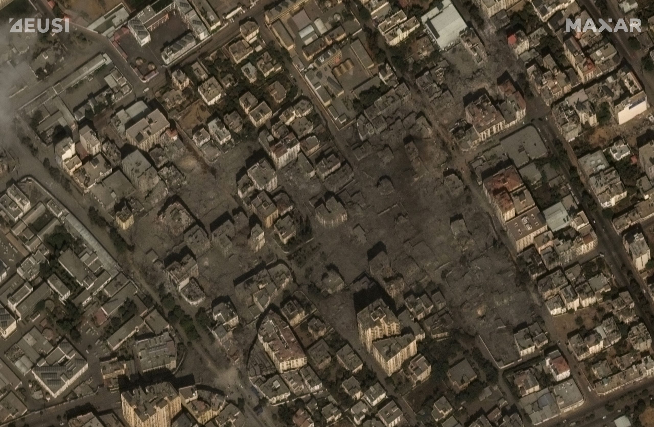
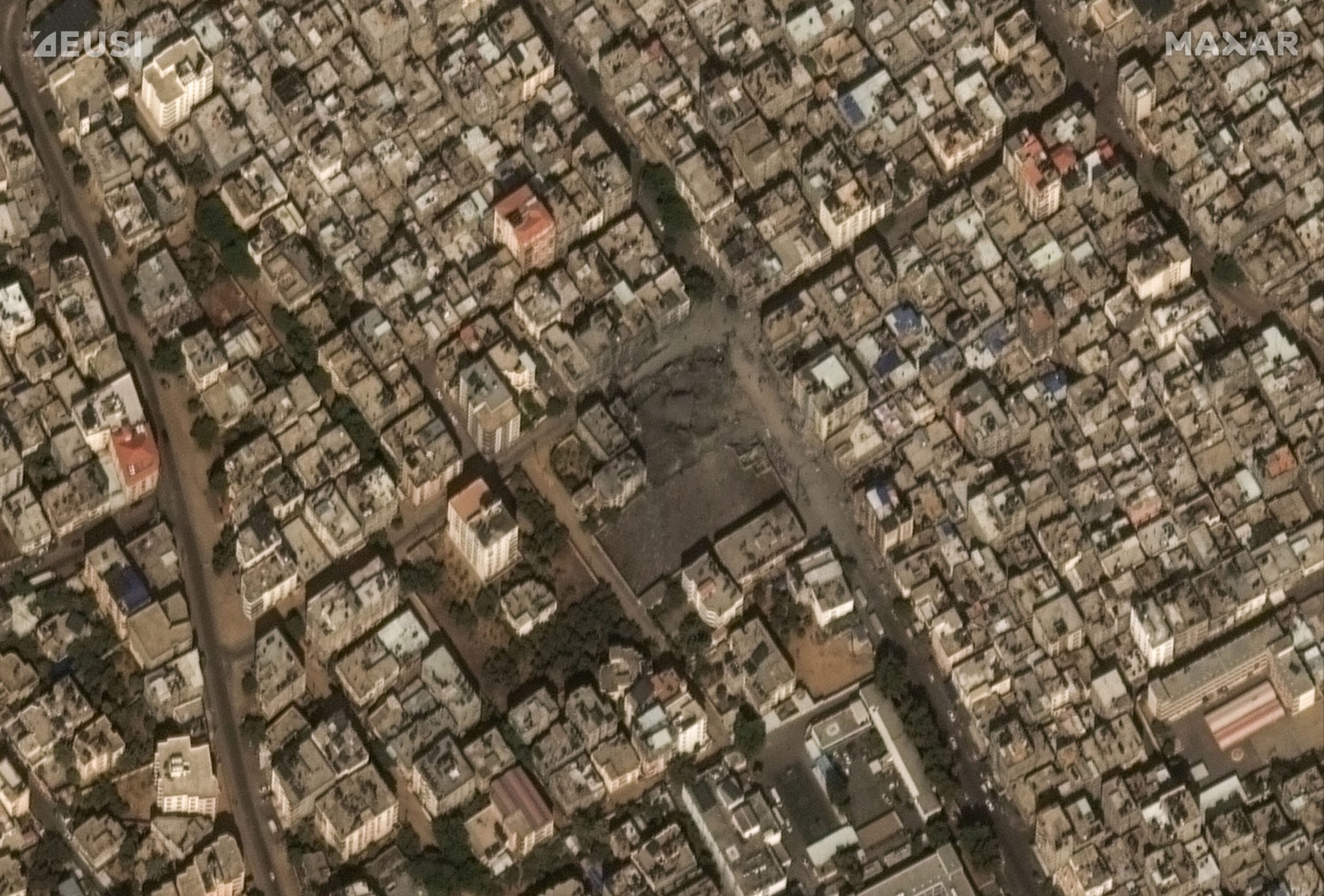
Satellite Imagery Shows Destruction in Gaza

Satellite Imagery Shows Destruction in Gaza
Courtesy: Twitter

Last Saturday, when Israelis were planning to celebrate the holiday of Simchat Torah, they faced surprise attacks from the globally designated militant group, Hamas that controls Gaza Strip.

This happened on the 50th anniversary of the 1973 Yom Kippur War that changed the politics of Middle East.

Followed by thousands of gruesome images and videos flooding the social media feeds and news channels covering the militants infiltrating Israel fenced border by paragliders, and attacking soldiers, communities living in the border area and forcefully taking Israel residents hostage

Hamas launched 5,000 rockets in over 20 minutes. Both sides have suffered thousands of causalities. International community calls for restraint.

European Space Imaging (EUSI) partner, Maxar collected new satellite imagery on October 10th of Gaza that reveals some of the ongoing military response to the recent Hamas attacks. The images focus on the aftermath of recent airstrikes in and around Gaza City. Maxar is continuously monitoring the situation and will provide additional updates.

Find the gallery here:


Bentley Systems’s Subsurface Company Acquires Flow State Solutions

0
Bentley Systems’s Subsurface Company Acquires Flow State Solutions

Bentley Systems announced that Seequent, The Bentley Subsurface Company, has signed an agreement to acquire Flow State Solutions, an industry leader in geothermal simulation software. The move further solidifies Seequent’s position as the most comprehensive subsurface software provider for the geothermal industry.

Flow State Solutions’ geothermal reservoir, wellbore, and surface network simulation software help project developers and operators better understand geothermal resources for asset development and optimization and improve well performance.

Combining Flow State Solutions’ Volsung portfolio with Seequent’s capabilities creates the most robust end-to-end solution for reservoir analysis available. Detailed models of the subsurface built-in Leapfrog Energy can be utilized in Flow State Solutions’ simulation environment to build a full picture of a geothermal asset.

Geothermal industry leaders are already utilizing both solutions to better understand their resources. Simon Webbison, Vice President, Exploration and Resource Management, Ormat Technologies Inc., said, “Ormat Technologies is one of the largest and most active geothermal companies globally, and we are delighted to see the combination of Seequent and Flow State Solutions software capabilities through this acquisition. We already use both companies’ software to better understand our geothermal assets and predict performance, and we are looking forward to working with the joint team to continue driving our success.”

Graham Grant, CEO, Seequent, said, “We are delighted to welcome the Flow State Solutions team to Seequent. Geothermal has the potential to help solve the world’s biggest energy challenges. With this acquisition, Seequent’s best-in-class subsurface analysis software enables a full understanding of geothermal asset performance.”

Flow State Solutions co-founder Jonathon Clearwater, who joins Seequent as Technical Domain Expert, Reservoir Engineering, said, “We are excited to join Seequent’s energy team. By combining Seequent’s expertise and our technical capability in geothermal modeling, we are looking forward to making a significant contribution to the renewable energy transition through improved management of natural resources.”

Image 1:

An example of a geological model built in Leapfrog Energy being utilized for reservoir simulation in Flow State Solutions software Volsung. Image courtesy of Flow State Solutions.

Image 2:

Simulated density changes in a geothermal reservoir, modeled and visualized in Flow State Solutions software Volsung. Image courtesy of Flow State Solutions.

Bentley Systems Announces Executive Appointments

0
Bentley Systems Announces Executive Appointments

Bentley Systems, the infrastructure engineering software company, announced executive appointments.

Kristin Fallon joins Bentley as Chief Marketing Officer, based in Annapolis, Maryland. Most recently, Fallon was Global Head of Brand and Digital Marketing at GE HealthCare, an $18 billion medical technology and software company. Among many accomplishments, she led the company’s rebranding as part of its separation from GE, for which she was named  Communicator of the Year by the Association of National Advertisers.

Prior to GE, she spent 10 years in international aid, leading marketing and communications for social, environmental, and economic development projects in Asia and Africa. Fallon earned a BA in economics at Wake Forest University and an MBA at the University of Maryland. She is a board member of the university’s Center for Social Value Creation and a board member of the International Advertising Association.

Fallon succeeds Chris Bradshaw who takes on the newly created role of Chief Sustainability Officer, based in Easton, Maryland, bringing together Bentley’s sustainability and education initiatives, with the objective of empowering Bentley’s users to achieve sustainable development goals, while ensuring the next generation of engineers has the tools and knowledge to succeed.

Colin Ellam joins as Chief Executive Officer of Cohesive, Bentley’s digital integrator business, based in Manchester, United Kingdom. Most recently, Ellam served as Global Head of Nuclear at Capgemini. He previously led the Capital Projects business for Accenture in the U.K., providing consulting and technology services for the infrastructure sector, including Transport, Utilities, and Power.

Ellam has worked across many geographies including Asia Pacific, Middle East, Europe, and Africa and lived and has worked in the United States for three years. He succeeds Mark Bew, who takes on an advisory role, having grown Cohesive into a global organization of more than 700 colleagues in 15 countries.

Oliver Conze joins as Senior Vice President, Bentley Infrastructure Cloud, based in Heidelberg, Germany. Most recently, Conze was Chief Product Officer at Customs4trade, a B2B SaaS startup automating international trade management, where he was responsible for product, technology, and operations.

Previously, Conze spent 15 years at SAP, where he held a variety of executive roles in product management, portfolio strategy, and customer success. Conze earned a master’s degree in industrial engineering at Karlsruhe Institute of Technology, an MS in Management Science at Stanford University, and a Ph.D. at University of St. Gallen.

Bentley Chief Operating Officer Nicholas Cumins, said, “This is a pivotal moment for the infrastructure sector and an exciting time to be in infrastructure engineering software. It is gratifying that Bentley Systems has attracted world-class talent to position the organization strongly for our next phase of growth and to help our users in the world’s leading infrastructure organizations design, build, and operate more sustainable and resilient infrastructure.”

Image 1:

Kristin Fallon, Chief Marketing Officer, Bentley Systems. Image courtesy of Bentley Systems.

Image 2:

Chris Bradshaw, Chief Sustainability Officer, Bentley Systems. Image courtesy of Bentley Systems.

Image 3:

Colin Ellam, Chief Executive Officer of Cohesive. Image courtesy of Bentley Systems.

Image 4:

Oliver Conze, Senior Vice President, Bentley Infrastructure Cloud. Image courtesy of Bentley Systems.

Carbonix, Woolpert Employ Drone to Collect Geospatial Data for Coal Mine Rehabilitation

0
Carbonix, Woolpert Employ Drone to Collect Geospatial Data for Coal Mine Rehabilitation

drone

Leading Australian drone manufacturer and solutions provider Carbonix is collaborating with global aerial survey specialist Woolpert to assist with the rehabilitation of one of New South Wales’ oldest open cut coal mines, using cutting-edge drone and geospatial data capture technology to help in this transition.

Situated in the Upper Hunter Region, rehabilitation areas will be surveyed and modelled to identify hotspots, which could inhibit the land’s ability to regenerate and rehabilitate. The aerial data collected will be instrumental in establishing a balanced mix of grasslands capable of supporting sustainable grazing and native vegetation corridors to enhance habitat connectivity. This balance will ensure the land’s potential for productive and eco-friendly use.

Woolpert selected Carbonix’s Volanti drone as an agile flight platform to enable data capture for hotspot monitoring. The Volanti presents a safer and significantly more cost-effective tool for areas too tight for conventional crewed aircraft, like helicopters, and too vast for multi-rotor drones. Volanti’s two-plus-hour flight time and ability to fly “low and slow” with sophisticated payloads enable the aircraft to obtain a detailed view of the area.

Carbonix CEO Philip van der Burg said the project with Woolpert is a great example of two companies collaborating to provide an innovative, cost-effective, and positive environmental survey solution through the use of long-range drones.

“This is a really exciting project because we get to witness the environmental benefits of long-range drone use, twofold: Firstly, eliminating the carbon emissions and noise of traditional aircraft and secondly providing key insights to accelerate the rehabilitation of a mine.

“Beyond hotspots, there is scope to expand the project to include multispectral imagery of vegetation and scanning to determine the health of the soil – something we have already done with a number of agriculture clients in Australia and the US,” said van der Burg.

Following the aerial capture, Woolpert will process and analyse the data. Its team of spatial analysts and modellers will extract detailed features from the image data to provide actionable hotspot insights.

Woolpert Key Account Manager – Resources, Anthony Boyd said it was great to work with the team at Carbonix and to leverage the technology ideally suited for the project.

“At Woolpert, we aim to deliver the best solution available for our clients, and recently we were asked to identify hotspots with a thermal camera in mine rehabilitation areas,” said Boyd.

“Woolpert partnered with Carbonix to provide detailed geospatial insights for our client, focused on their specific needs and requirements from an environmental and community perspective.”

WGIC Unveils New Brand Identity – Geospatial in Everything, Geospatial for Everyone

0
WGIC Unveils New Brand Identity – Geospatial in Everything, Geospatial for Everyone

The World Geospatial Industry Council (WGIC) has announced the unveiling of a new, mature, and all-encompassing brand identity – on its journey as a global advocate for the geospatial industry.

WGIC’s new logo and all-inclusive tagline – Geospatial in Everything, Geospatial for Everyone – stand as a testament to the omnipresence of geospatial technologies across diverse economic sectors. WGIC’s new corporate identity, unveiled after five years of dedicated operations, is emblematic of its unwavering and expansive commitment to enhancing the geospatial industry’s influence worldwide.

Bryn Fosburgh, President-WGIC and Senior Vice President-Trimble, conveyed his excitement over the rebranding, stating, “Geospatial information, processes, and technologies touch every aspect of our life, and it is much more complex than just a simple location or route. Today and in the future, geospatial information will fuel the metaverse and describe and operate the digital twins and several processes in industries such as land information, construction, utilities, agriculture, and climate change. WGIC’s new logo, color palette, and tagline reflect all the elements that geospatial technology stands for and the organization’s expansive vision for the industry’s future.”

Barbara Ryan, WGIC Executive Director, remarked, “The best branding tells a story, and I am excited about “the story” that the new WGIC branding portrays. Our tagline – Geospatial in Everything, Geospatial for Everyone – is reinforced by our new logo. Pay attention to each color and cube in the logo, and you will see that the atmosphere, land, oceans, forests, and built environment are all reflected and interconnected, just like the interconnected Earth upon which we live.”

WGIC

The rebranding introduces a thoughtfully chosen logo and color palette. Each color carries significant symbolism: blue for the atmosphere, green for the biosphere, aquamarine blue for the hydrosphere, brown for the geosphere, and grays for the human sphere and built environment. This meticulous selection underscores WGIC’s holistic approach to the geospatial field, enriches the brand, and underscores the interconnectedness of geospatial information with every facet of human life.

The unveiling of WGIC’s rebranding, close on the heels of the appointments of its president (Bryn Fosburgh) and executive director designate (Aaron Addison), signifies an exciting new phase in the organization’s history, solidifying its position as a force to reckon with in the global geospatial ecosystem.

WGIC acknowledges VRS Studio for their support in evolving its new brand identity.

Breaking Barriers: Making Satellite Data Accessible

0
Breaking Barriers: Making Satellite Data Accessible

As we seek innovative ways to monitor and protect our environment, companies like Planet are at the forefront of technological advancements in Earth Observation.

In this exclusive interview, Kevin Weil, President of Product & Business at Planet, shares insights into the mission, and the profound impact of integrating satellite imagery with cutting-edge AI.

Sustainability has been a major talking point for about a decade now, and Planet, as a strong advocate of sustainable practices, has been involved in numerous projects to further this cause. What are the current sustainability missions that Planet is focusing on?

We have more than 900 customers and partners, and a substantial portion of them are actively engaged in various sustainability initiatives.

One noteworthy program we have undertaken, and frequently discussed, is the NICFI program. Through this initiative, we collaborated with the government of Norway to create a comprehensive dataset encompassing all of the world’s tropical forests.

Our daily global satellite imaging capability enables us to generate this dataset, which covers the area between specified latitudes that define the world’s tropical forests.

Providing this data as a public good has enabled researchers to study and comprehend deforestation and various climate-related changes, ultimately contributing to their understanding of the sustainable economics of forest communities.

We now observe, from NICFI and other sources, the publication of peer-reviewed scientific papers every day that cite Planet data. This amounts to thousands of papers over the course of our business history, primarily because we have worked diligently to make our data accessible to researchers.

We believe that good things happen when we do so, as we witness the emergence of new use cases and innovative solutions.

We also have an ongoing mapping initiative aimed at creating a living atlas of the world’s renewable energy sources. This project is a collaborative effort with Microsoft and the Nature Conservancy. Essentially, we are generating a living map that encompasses all sustainable, large-scale wind or solar developments worldwide.

This initiative aims to make such data accessible and provide a ground truth for the locations of sustainable energy production. It enables users to delve into comparisons, such as how countries are progressing relative to one another, or the growth of individual states or provinces within countries. This initiative also allows for an analysis of wind versus solar development.

Recently, Planet’s satellite imagery was combined with Microsoft’s AI to assess damages in the Maui wildfires. Tell us more about the project?

This work initially began as a collaboration centered on Ukraine. Our joint objective was to conduct automated building damage assessments in the conflict zone.

Specifically, we focused on cities that had experienced occupation and, upon liberation, required substantial rebuilding efforts. We aimed to evaluate how effectively we could utilize our data and Microsoft’s AI to swiftly determine the extent of damage to buildings, road conditions, and access paths within specific areas.

By providing such information in an accessible format, we could gain insight into the resources needed for reconstruction and identify priority areas. This initial project spanned approximately one to two months.

As we neared completion of this work, the earthquake occurred in Turkey (Turkiye), prompting us to swiftly adapt our techniques. Within a matter of days, we managed to provide automated damage assessments for buildings across the earthquake-affected zone. This rapid response was crucial for assisting first responders in understanding the extent of damage, identifying navigable roads, and planning their actions effectively.

Subsequently, when wildfires struck Maui, we applied the same approach once again. With each iteration, we have improved our efficiency and response time. These experiences underscore the incredible potential of AI when combined with Planet’s imagery for real-time assessments and disaster response.

What are some other use cases to which this kind of integration can contribute?

Our partner, LiveEO, integrates Planet data with AI in a really exciting work around disaster management. Specifically, they focus on the inspection of linear features such as rail corridors and power lines to identify vegetative encroachment.

Often, some of the most significant wildfires are ignited when a tree falls onto a power line in the midst of a forest. Hence, it is crucial to automate the process of identifying trees that are tall enough and in close proximity to potentially hazardous positions along thousands of miles of power lines.

A similar need exists for rail lines, although it may not lead to forest fires; overgrown vegetation on rail lines can still result in significant delays.

Historically, this type of work has required periodic flights with airplanes or other costly and non-scalable methods. However, by utilizing daily satellite imagery in conjunction with AI, we can now efficiently pinpoint areas where attention is needed. This approach enhances safety, saves substantial government and taxpayer resources, and streamlines the overall process.

Planet has been preparing to launch the Tanager hyperspectral satellites. Tell us more about these satellites and the roles of Carbon Mapper and NASA in the mission?

This is a significant milestone for us because historically, we have exclusively launched optical satellites. However, with Tanager, we are launching hyperspectral satellites.

These satellites possess the capability to detect a wide range of substances that are imperceptible to the human eye. Specifically, it can identify chemical fingerprints of diverse materials and compounds, which serves as the primary objective.

The involvement of Carbon Mapper is pivotal because it enables the detection of carbon and methane emissions, both of which contribute to global warming and remain relatively unknown in terms of their precise sources.

These satellites will offer more than a broad assessment of carbon or methane emissions within a general area. They will have the capability to pinpoint specific sources of emissions, such as a leak in a particular pipe. This level of precision can enable us to identify and address emissions with great accuracy.

With governments increasingly making commitments to advance their sustainability efforts, this capability provides them with a means to acquire accurate and reliable information on their progress and areas where improvements are needed. It also serves as a tool for holding emitters accountable.

We are fortunate to have forged a partnership with NASA JPL, where they are essentially conducting a technology transfer of the hyperspectral sensor itself.

This sensor is the result of decades of their dedicated work, and it stands as an exquisite piece of technology. They have honed and perfected it over many years, but on airplanes. Our collaboration will deploy this sensor in space.

What does the roadmap ahead look like for Planet?

I’d like to highlight three key points. Firstly, we are actively developing new datasets and are committed to pushing the boundaries by creating innovative datasets that the world has never encountered before, akin to our achievements with PlanetScope and our Dove constellation.

We are in the process of upgrading our SkySat constellation, specifically the high-resolution tasking constellation, to Pelican. This upgrade will deliver substantial improvements across the board, offering higher resolution and reduced latency. We also introduced the hyperspectral constellation, Tanager.

The first satellites for both these constellations are scheduled for launch in the very near future. Therefore, we remain dedicated to advancing the frontier by creating novel datasets.

The second focus revolves around what we just discussed—making our data more user-friendly. This entails the creation of Planetary Variables and other derivatives that serve as simplified building blocks, facilitating ease of use.

Our objective is to expand the range of applications and systems that leverage AI in conjunction with our imagery. This enables us to provide answers to users without requiring them to possess advanced geospatial expertise. Ultimately, we aim to showcase the extensive possibilities that can be unlocked through the effective utilization of satellite imagery.

Thirdly, a significant aspect pertains to the platform and workflows. Our aim is to seamlessly integrate our space capabilities into GIS platforms that users commonly employ. We want to eliminate the need for organizations to construct custom infrastructure pipelines, which can be a hindrance to obtaining the answers they seek.

Our vision is to empower users by providing them with advanced capabilities through what essentially constitutes a geospatial cloud platform, a vision that stems from our acquisition of Sinergise and Sentinel Hub.

The more capabilities we offer, the faster users can arrive at solutions, and the more we contribute to the growth of this industry.